| Pages:
1
2 |
805gregg
Super Nomad
   
Posts: 1344
Registered: 5-21-2006
Location: Ojai, Ca
Member Is Offline
|
|
| Quote: | Originally posted by dianaji
| Quote: | Originally posted by David K
| Quote: | Originally posted by DENNIS
Thanks David....Your directions are way more clear than mine would have been. |
My pleasure Dennis,
Here is the 2007 AAA map showing the Blvd. 2000 (18.4 + 7.1 miles long... 5.9 miles from the Puerto Nuevo exit):
|
LOVE that map...it will help so much in my adventures, being a newbie! |
You don't have a map of Baja? And you live there. Looks like a AAA map free to members.
|
|
|
805gregg
Super Nomad
   
Posts: 1344
Registered: 5-21-2006
Location: Ojai, Ca
Member Is Offline
|
|
| Quote: | Originally posted by DENNIS
It's terrible and I've had it. This is my normal way of passage when going to the states and it used to be well kept and comfy.
No more. The road is being widened, which is good but, it's five miles of dirt and bad road coming from Ensenada before you meet the hard surface
which has been upkeep denied for the remaining trip to Tecate. It's a stressful trip for a driver for having to concentrate on the surface of the
road. Some of the pot-holes will ruin your day.
My choice will be to go north on the toll road and go up Blvd. 2000 to the Tecate toll road and go over on that. I havn't clocked it as yet but, I'm
told it adds eight miles to the trip. Not a bad price to pay for keeping the front end in your car in one piece. |
Bad roads = good people.
|
|
|
bajaguy
Elite Nomad
     
Posts: 9247
Registered: 9-16-2003
Location: Carson City, NV/Ensenada - Baja Country Club
Member Is Offline
Mood: must be 5 O'clock somewhere in Baja
|
|
And you can pick up great Ensenada and TJ city street maps at the AM-PM PEMEX stations
|
|
|
David K
Honored Nomad
        
Posts: 65436
Registered: 8-30-2002
Location: San Diego County
Member Is Offline
Mood: Have Baja Fever
|
|
| Quote: | Originally posted by Phil S
David. You have a blow up map of coming into Tecate and going east (how far east) before "getting in line"!!!!??????? Wendy & I tried it last
December, but missed it somewhere, and ended up on the "wrong side" of the barriers, and after driving circles going further east, finally got on it.
How the h___l I did that, I'll never know!!!!!!!!!!!!!! Yeah I know. follow the signs. (I thought I had) |
Hi Phil,
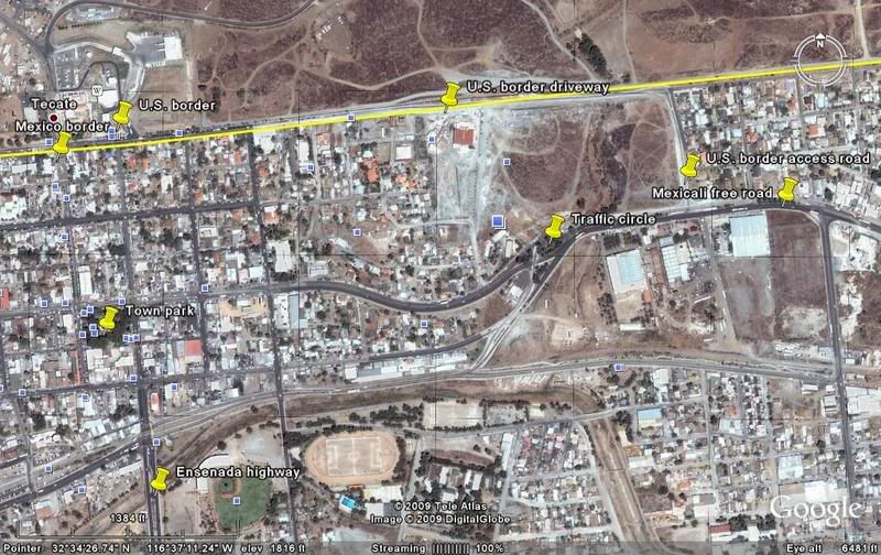
The entrance to the U.S. border 'driveway' is just east of the traffic circle, east of downtown on the Mexicali Free road.
I will try and post some photos for you!
|
|
|
David K
Honored Nomad
        
Posts: 65436
Registered: 8-30-2002
Location: San Diego County
Member Is Offline
Mood: Have Baja Fever
|
|
Finding border road in Tecate
See if this helps!

|
|
|
David K
Honored Nomad
        
Posts: 65436
Registered: 8-30-2002
Location: San Diego County
Member Is Offline
Mood: Have Baja Fever
|
|
Coming from Ensenada on Hwy. 3 or just down the hill from the toll road at the Hwy. 3 interchange... you will fork off to the right (well signing
Garita USA. Hwy. 94, San Diego, etc.) along the railroad tracks on a 4 lane street.... goes to the 'traffic circle' (Free Mexicali hwy.) then soon
make a left turn to access the U.S. border (well signed).
You must go to the east side of town to the access road, no short cuts from downtown streets!
[Edited on 3-3-2009 by David K]
|
|
|
Pescador
Ultra Nomad
    
Posts: 3587
Registered: 10-17-2002
Location: Baja California Sur
Member Is Offline
|
|
We were in a hurry to get home and we got to Ensenada around 5:30 or so on Tuesday of last week, and decided that most of the workers would be done
for the day which should allow an easy trip from Ensenada to Tecate. Actually all went well and while there was some gravel and a few rough sections
closer to Tecate, it was still a good drive and we hit the border at 8:00PM with no wait at all. I was expecting it to be much worse following the
discussio here but the Dodge truck, with Lance Camper and a cargo van did very well and while I would have preferred to drive the last few kilometers
in the daytime, it was ok.
|
|
|
McNulty
Junior Nomad

Posts: 38
Registered: 1-4-2009
Location: CA
Member Is Offline
|
|
I drove that road for the first time coming back from a trip to Guerrero Negro over presidents weekend in very heavy rain, which definitely added to
the experience. There were some huge puddles from the rain, and the road was less than perfect but what do you expect when you're in mexico?
All I know is that flying through those puddles sure cleaned off all the salt from the bottom of my car after driving on the salt flats in GN.
Their are 3 kinds of people in the world, those who can count and those who can\'t.
|
|
|
Bajahowodd
Elite Nomad
     
Posts: 9274
Registered: 12-15-2008
Location: Disneyland Adjacent and anywhere in Baja
Member Is Offline
|
|
I remember before Homeland Security decided to start really checking things out and delaying passage, you could drive straight up to the border on the
road that passes the town park. At least now, they are not clogging the main part of town with border backup.
|
|
|
| Pages:
1
2 |

