| Pages:
1
2
3 |
capt. mike
Elite Nomad

Posts: 8085
Registered: 11-26-2002
Location: Bat Cave
Member Is Offline
Mood: Sling time!
|
|
dos gringos - are you going to refine this more? nice work.
how about blowing it up a bit and spotting where the airport is in relation to town and the high way?
thx.
formerly Ordained in Rev. Ewing\'s Church by Mail - busted on tax fraud.......
Now joined L. Ron Hoover\'s church of Appliantology
\"Remember there is a big difference between kneeling down and bending over....\"
www.facebook.com/michael.l.goering |
|
|
David K
Honored Nomad
Posts: 65545
Registered: 8-30-2002
Location: San Diego County
Member Is Offline
Mood: Have Baja Fever
|
|
Asuncion from space!
The first two are the view at 2,500' with north at the top:


This one is at 8,500' with the airport marked with a yellow pin (about 2 miles from town):
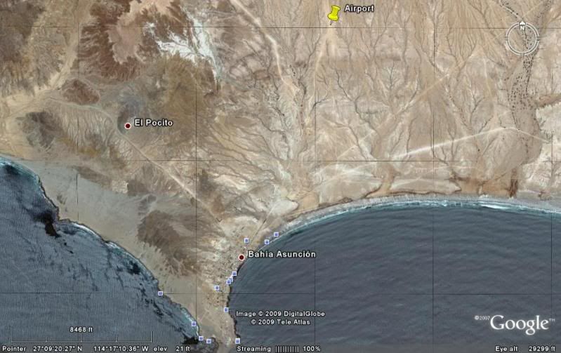
This is at an angle, still looking north (at the top)... Shari and Juan's place near the lower left corner.

|
|
|
capt. mike
Elite Nomad
Posts: 8085
Registered: 11-26-2002
Location: Bat Cave
Member Is Offline
Mood: Sling time!
|
|
is the number relative to horizontal scale or elevation above ground/sea level?
formerly Ordained in Rev. Ewing\'s Church by Mail - busted on tax fraud.......
Now joined L. Ron Hoover\'s church of Appliantology
\"Remember there is a big difference between kneeling down and bending over....\"
www.facebook.com/michael.l.goering |
|
|
twogringos
Nomad
Posts: 184
Registered: 1-7-2007
Location: Bahia Asuncion/Color-Country
Member Is Offline
Mood: I feel more like I do now than I ever have before
|
|
Shari, I was hoping you would help. I have put my working map on a file share site (too large to post here). Maybe you could print it out and mark
it up.
http://www.keepandshare.com/doc/view.php?id=1211200&da=y... (PDF 55K)
or
http://www.keepandshare.com/doc/view.php?id=1211201&da=y... (JPG 205K)
capt. mike, I don't think I can enlarge the map without starting over, but I'm green at this. I'll experiment. I know I can add the runway if I had
coordinates at each end, I 'm just not sure I can enarge my google earth photo (see links above) to trace over it.
|
|
|
David K
Honored Nomad
Posts: 65545
Registered: 8-30-2002
Location: San Diego County
Member Is Offline
Mood: Have Baja Fever
|
|
| Quote: | Originally posted by capt. mike
is the number relative to horizontal scale or elevation above ground/sea level? |
The bottom numbers (GPS & elevation is for the pointer, and means nothing as far as the image posted).
The scale bar and number of feet above it represent just that, the scale of the map shown... and more like the approx. elevation of the view. The
first two are about 2,500' up and the third about 8,500' up... high enough so I could show the town and your airport... if you ever fly out there!
In Shari's slide show, she shows two planes parked out there.
|
|
|
Bajaboy
Ultra Nomad
Posts: 4375
Registered: 10-9-2003
Location: Bahia Asuncion, BCS, Mexico
Member Is Offline
|
|
Any idea how to post or share a Google Earth file? I created a map of town with many of the businesses, etc., a while ago. The map is too populated
for a useful screen shot.
|
|
|
David K
Honored Nomad
Posts: 65545
Registered: 8-30-2002
Location: San Diego County
Member Is Offline
Mood: Have Baja Fever
|
|
| Quote: | Originally posted by twogringos
Shari, I was hoping you would help. I have put my working map on a file share site (too large to post here). Maybe you could print it out and mark
it up.
http://www.keepandshare.com/doc/view.php?id=1211200&da=y... (PDF 55K)
or
http://www.keepandshare.com/doc/view.php?id=1211201&da=y... (JPG 205K)
capt. mike, I don't think I can enlarge the map without starting over, but I'm green at this. I'll experiment. I know I can add the runway if I had
coordinates at each end, I 'm just not sure I can enarge my google earth photo (see links above) to trace over it. |

|
|
|
capt. mike
Elite Nomad
Posts: 8085
Registered: 11-26-2002
Location: Bat Cave
Member Is Offline
Mood: Sling time!
|
|
thx DK - i was thinking elevation then imagined the view from my bird's eye at 2500' or 8500' and thot the image seemed higher up than that.
i am pretty weak at using googley earth. fun stuff tho.
yes - i need to get there one of these days. right now i am simply not equipped to go from a time standpoint. but it will be there a while longer i am
figuring!
formerly Ordained in Rev. Ewing\'s Church by Mail - busted on tax fraud.......
Now joined L. Ron Hoover\'s church of Appliantology
\"Remember there is a big difference between kneeling down and bending over....\"
www.facebook.com/michael.l.goering |
|
|
David K
Honored Nomad
Posts: 65545
Registered: 8-30-2002
Location: San Diego County
Member Is Offline
Mood: Have Baja Fever
|
|
| Quote: | Originally posted by Bajaboy
Any idea how to post or share a Google Earth file? I created a map of town with many of the businesses, etc., a while ago. The map is too populated
for a useful screen shot. |
Not sure if you are talking about something other than a single image Zac? If you mean your personal file of places on Google Earth... I think you can
only post a link to that, as a single image would need to be so high to show all of Baja, the marker pins wouldn't be well defined. Perhaps bajalou or
another Google map user can help?
When I want to show a Google Earth image, as I have above, I first save it to a file on my PC (let me know if anyone needs the steps to do that).
Second, I open up my photobucket.com album then copy that file to Photobucket (set on 15" screen size reduction so it dowsn't distort the Nomad page
wider than standard monitors can show).
Third, I paste the url [IMG] link onto the Nomad page.
|
|
|
Neal Johns
Super Nomad
Posts: 1687
Registered: 10-31-2002
Location: Lytle Creek, CA
Member Is Offline
Mood: In love!
|
|
BajaBoy,
To send someone an email containing a jpg picture of what is on your Google Earth screen, in Google Earth, click File, Email, and then Email Image.
To send someone an email containing the info that will open the image on your screen in their copy of Google Earth, in Google Earth, click File,
Email, and then Email View.
To send someone an email containing all or part of your Google Earth "My Places", check the box(s) of the places you want to send and then in Google
Earth, click File, Email and then Email Placemark.
For capturing any image on your monitor, I use the free version of PrintScreen from http://www.gadwin.com/download/
[Edited on 5-29-2009 by Neal Johns]
My motto:
Never let a Dragon pass by without pulling its tail!
|
|
|
Bajaboy
Ultra Nomad
Posts: 4375
Registered: 10-9-2003
Location: Bahia Asuncion, BCS, Mexico
Member Is Offline
|
|
Thanks Neal!
|
|
|
Cyanide41
Nomad
Posts: 303
Registered: 1-7-2009
Location: Tijuana
Member Is Offline
|
|
twogringos.... just nit picking... but shouldn't it be "Juarez"?
|
|
|
David K
Honored Nomad
Posts: 65545
Registered: 8-30-2002
Location: San Diego County
Member Is Offline
Mood: Have Baja Fever
|
|
| Quote: | Originally posted by Cyanide41
twogringos.... just nit picking... but shouldn't it be "Juarez"? |
I may have not been 'loud' enough when I posted this a few days ago  : :
posted on 5-26-2009 at 02:02 PM
Check the spelling of main street... Thanks for sharing your map!
|
|
|
805gregg
Super Nomad
Posts: 1344
Registered: 5-21-2006
Location: Ojai, Ca
Member Is Offline
|
|
I'm not trying to start anything here, but why would you need a map? It's so small, if you ask directions, I'm sure everyone knows all the residences.
|
|
|
David K
Honored Nomad
Posts: 65545
Registered: 8-30-2002
Location: San Diego County
Member Is Offline
Mood: Have Baja Fever
|
|
Basically a one business street town... I was surprised to see such a detailed 'street' map that Shari had... Shows some planning!
|
|
|
Cyanide41
Nomad
Posts: 303
Registered: 1-7-2009
Location: Tijuana
Member Is Offline
|
|
| Quote: | Originally posted by David K
| Quote: | Originally posted by Cyanide41
twogringos.... just nit picking... but shouldn't it be "Juarez"? |
I may have not been 'loud' enough when I posted this a few days ago :
posted on 5-26-2009 at 02:02 PM
Check the spelling of main street... Thanks for sharing your map! |
What's that DK? Could you speak up? 
Your right you did say that a few days ago. It was Monday. That's my excuse
|
|
|
twogringos
Nomad
Posts: 184
Registered: 1-7-2007
Location: Bahia Asuncion/Color-Country
Member Is Offline
Mood: I feel more like I do now than I ever have before
|
|
I acknowledged the typo 5-27. Sorry I can't go back and edit the photo.
|
|
|
DianaT
Select Nomad
Posts: 10020
Registered: 12-17-2004
Member Is Offline
|
|
TwoGringos
Hi,
We are looking forward to seeing both of you again in August in Bahia Asuncion.
However, I am curious about this map project. I am a person who gets lost in parking lots, and I can't imagine getting lost in Bahia Asuncion. And
the majority of streets do not have names, if they really are streets.
Also, we know that there are plans of putting a street behind our house and another one in front of your home, soon, we are told. 
There are roads all over Bahia Asuncion that do not exist. You can drive on one today, then the land owner looks at the map in the land office and
sees that it is not a road and blocks it off. Then it takes about 3 days for a new road to appear---just as soon as the ground is a little more
packed from cars driving around where the road is blocked.
Usually we find people with directions like, drive up the hill behind the Tel Cel, look for a white house with lots of plants, and my red truck. So,
a map would not really help.
And, thanks to our new delegado, we now have signs that point to the airport and to the dump. Boy, talk about lots of "roads", that area is covered
with them. But even there, It is difficult to get really lost. We just look for the power lines and head that direction.
But, I am sure there is a good reason and it could be fun to see how many changes need to be made every month or so.
See you at fiesta time!
Diane
[Edited on 6-2-2009 by jdtrotter]
|
|
|
msteve1014
Senior Nomad
Posts: 947
Registered: 12-2-2006
Member Is Offline
|
|
I have a picture of a "map" of a small part of La Bocana, where my house is. It shows the streets and the lots with the names of the people that own
the lot. Except that most of the streets don't exist. There are streets where none are shown, and people have built homes where there should be a
street I love it. I love it.
|
|
|
shari
Select Nomad
Posts: 13052
Registered: 3-10-2006
Location: bahia asuncion, baja sur
Member Is Offline
Mood: there is no reality except the one contained within us "Herman Hesse"
|
|
Actually David, there are LOTS of businesses worthy of finding that are NOT on the main drag. There are clothing stores, a nice jewellery store, an
excellent taco restaurant type place, killer hot dog stand, the telegraph office, depositos, the cultural center, clothing stores, hardware stores,
restaurants etc. that are off the main street and sometimes hard to find...even for me. A map would be usefull IMHO particularly for those hard to
find businesses.
|
|
|
| Pages:
1
2
3 |


