| Pages:
1
2
3 |
David K
Honored Nomad
        
Posts: 65437
Registered: 8-30-2002
Location: San Diego County
Member Is Offline
Mood: Have Baja Fever
|
|
Berrendo Canyon is really nice... blue palms galore!
After my first visit there with Jide and Baja Lou in 2004, I returned with Baja Angel in 2006...


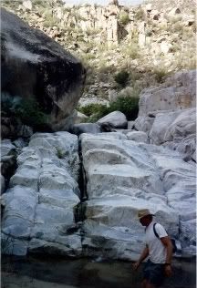
The giant grotto at the end of the canyon is something to see... boulders this size in one piece are pretty amazing!
It was perhaps a half mile hike to the grotto from the parking spot... maybe a bit more.
|
|
|
Mexitron
Ultra Nomad
    
Posts: 3397
Registered: 9-21-2003
Location: Fort Worth, Texas
Member Is Offline
Mood: Happy!
|
|
At the grotto the canyon splits...to the south is a canyon full of believe it or not Oaks (Q. chrysophylis if my memory serves me)...to the west is
the canyon that leads into the ampitheater--its got a couple of white knuckle spots (or you can hike behind and around the canyon to avoid)...its the
ampitheater that is the epic destination and one of the main population centers of the blue palms--they are growing on the exposed Sierra type granite
everywhere!
|
|
|
David K
Honored Nomad
        
Posts: 65437
Registered: 8-30-2002
Location: San Diego County
Member Is Offline
Mood: Have Baja Fever
|
|
| Quote: | Originally posted by Mexitron
At the grotto the canyon splits...to the south is a canyon full of believe it or not Oaks (Q. chrysophylis if my memory serves me)...to the west is
the canyon that leads into the ampitheater--its got a couple of white knuckle spots (or you can hike behind and around the canyon to avoid)...its the
ampitheater that is the epic destination and one of the main population centers of the blue palms--they are growing on the exposed Sierra type granite
everywhere! |
Cool! Never hiked further up than the grotto... It looked like the end of the canyon was there, as it is steep to the ridge line right behind the
grotto... I guess you have to hike up to that ridge?
Here is a photo of the grotto from a distance before reaching the giant boulder, and the area past it:

|
|
|
Barry A.
Select Nomad
      
Posts: 10007
Registered: 11-30-2003
Location: Redding, Northern CA
Member Is Offline
Mood: optimistic
|
|
On "Berrendo Canyon" ------Great pics and information. Fun, fun!!! Thanks Mexitron and David.
Barry
|
|
|
Mexitron
Ultra Nomad
    
Posts: 3397
Registered: 9-21-2003
Location: Fort Worth, Texas
Member Is Offline
Mood: Happy!
|
|
Berrendo:

|
|
|
mtgoat666
Platinum Nomad
       
Posts: 20564
Registered: 9-16-2006
Location: San Diego
Member Is Offline
Mood: Hot n spicy
|
|
| Quote: | Originally posted by David K
Cool! Never hiked further up than the grotto... It looked like the end of the canyon was there, as it is steep to the ridge line right behind the
grotto... I guess you have to hike up to that ridge?
|
dk: it is true that all of the best places are roadless and inaccessible. put on your hiking boots!
|
|
|
David K
Honored Nomad
        
Posts: 65437
Registered: 8-30-2002
Location: San Diego County
Member Is Offline
Mood: Have Baja Fever
|
|
Hmmm... I will need to have a new look! We are leaving to Plaster City now (off road race pit support), so in a couple days ... Thanks Steve!
|
|
|
Barry A.
Select Nomad
      
Posts: 10007
Registered: 11-30-2003
Location: Redding, Northern CA
Member Is Offline
Mood: optimistic
|
|
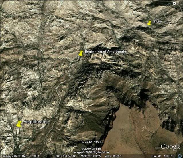
David-------Is your aerial shot (google earth) oriented north towards the top??-----I am having a little difficulty with it. Whats the light colored
area in the lower right? Parral??
Barry
|
|
|
bajalou
Ultra Nomad
    
Posts: 4459
Registered: 3-11-2004
Location: South of the broder
Member Is Offline
|
|
Barry
Look at the compass int the upper right corner of the Google earth shots. In in the last two of Davids, the arrow points right indicating the right
margin is North so west is up.
No Bad Days
\"Never argue with an idiot. People watching may not be able to tell the difference\"
\"The trouble with doing nothing is - how do I know when I\'m done?\"
Nomad Baja Interactive map
And in the San Felipe area - check out Valle Chico area |
|
|
David K
Honored Nomad
        
Posts: 65437
Registered: 8-30-2002
Location: San Diego County
Member Is Offline
Mood: Have Baja Fever
|
|
| Quote: | Originally posted by bajalou
Barry
Look at the compass int the upper right corner of the Google earth shots. In in the last two of Davids, the arrow points right indicating the right
margin is North so west is up. |
Exactly... the first one in north at top showing the overall area... the next ones are looking into the canyon and flying over the canyon to the hot
spring.. so all are facing west... as it is west from the entrance to the hot spring.
Mexitron, I am having a hard time figuring out your image... and may do a 3-D version of it (to help me, anyway)! 
Goat... You cannot drive to the grotto in Berrendo, so we did hike to it... I did not hike any more, because I didn't see any more canyon... it looked
like a dead and past the grotto. Mexitron gives new reasons to have a third look. However, we are a bit more mature (older) than you, so pretending to
be a mountain goat isn't as much fun as driving a Tacoma to places in Baja.
|
|
|
BajaRob
Senior Nomad
  
Posts: 722
Registered: 9-15-2003
Location: Bahia Santa Maria y Newport Or
Member Is Offline
Mood: Life is good
|
|
Update
Five of our neighbors driving three Polaris side x sides ( two RZRs and an XP ) made a day trip to Matomi Ranch yesterday. They said that the trip was
about the same as going into Mike's Sky Ranch from the South.
|
|
|
Mexitron
Ultra Nomad
    
Posts: 3397
Registered: 9-21-2003
Location: Fort Worth, Texas
Member Is Offline
Mood: Happy!
|
|
David--the actual location of the Grotto may be further up--see if you can verify, that may be throwing you off--- its where one of the side canyons
splits off, but its been around eleven years since I was up there....
|
|
|
Barry A.
Select Nomad
      
Posts: 10007
Registered: 11-30-2003
Location: Redding, Northern CA
Member Is Offline
Mood: optimistic
|
|
David, Lou, Mexitron, etc.---------Been gone to Chico for two days, so catching up here. I mis-spoke before------it was the aerial that Mexitron
posted of Barrendo Canyon that was (and still is) confusing me. I am having a hard time orienting myself on that photo, and ID'ing just what is a
"canyon" and what is a "ridgetop". And, what is the light colored area at the lower right? I now understand the compass rose in the upper
right------thanks Lou.
Help. (if that's possible)  
Barry
|
|
|
bajalou
Ultra Nomad
    
Posts: 4459
Registered: 3-11-2004
Location: South of the broder
Member Is Offline
|
|
Barry
The areal was taken by me during a fly over several years ago. It is taken from deeper in the canyon looking east or out to Valle Chico . The white
areas are gravel and sandy portions of the canyon.
From "Road End" you hike up the canyon past the "farm area" and around a bend to the hot spring. If you go farther up you come to a lone palm in the
middle of the canyon where it splits, the main portion heading west and the smaller heading south. About where the word"Palm" is, there is a fence
and remains of a corral on the right side heading up stream.
Hope this makes sense to you Barry,
No Bad Days
\"Never argue with an idiot. People watching may not be able to tell the difference\"
\"The trouble with doing nothing is - how do I know when I\'m done?\"
Nomad Baja Interactive map
And in the San Felipe area - check out Valle Chico area |
|
|
David K
Honored Nomad
        
Posts: 65437
Registered: 8-30-2002
Location: San Diego County
Member Is Offline
Mood: Have Baja Fever
|
|
| Quote: | Originally posted by Mexitron
David--the actual location of the Grotto may be further up--see if you can verify, that may be throwing you off--- its where one of the side canyons
splits off, but its been around eleven years since I was up there.... |
Is what I call the grotto the same as your 'grotto', I wonder?
The photos I posted of the giant boulders with me standing at the base is what I call the grotto... It is 1/2 to 1 mile hike up Berrendo from tyhe
furthest place you can drive in the white sand arroyo (blocked by rocks).
Thanks and this is fun! I will do my version of a fly-over with Google soon, as I did with Agua Caliente.
|
|
|
Mexitron
Ultra Nomad
    
Posts: 3397
Registered: 9-21-2003
Location: Fort Worth, Texas
Member Is Offline
Mood: Happy!
|
|
Okay, I think I've found your grotto David--its further down the canyon than where I'm thinking of---check out the large rock in the background---it
looks like the same one in your photo:

|
|
|
Mexitron
Ultra Nomad
    
Posts: 3397
Registered: 9-21-2003
Location: Fort Worth, Texas
Member Is Offline
Mood: Happy!
|
|
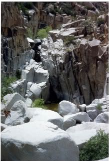
Here's the grotto I'm thinking of--further up canyon--its a pool you can almost swim in:

|
|
|
Mexitron
Ultra Nomad
    
Posts: 3397
Registered: 9-21-2003
Location: Fort Worth, Texas
Member Is Offline
Mood: Happy!
|
|
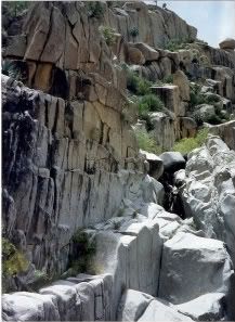
And then a little higher up view of the same place--gets pretty steep through this gap but once you get around this its probably another hour or two
to the ampitheater...its all doable up and back in a long day if the canyon has been scoured out by heavy rains but veeerrryyy slow going when all the
thorny flora has grown in along the watercourse. In fact, on this hike in 1995ish, Huddo and I stopped here because it had taken us until 2pm to get
to this point because of the thorn scrub. Later, in 1998, after Hurricane Nora cleaned out the canyon we scampered all the way up to the ampitheater
in about half a day.:

|
|
|
bajalou
Ultra Nomad
    
Posts: 4459
Registered: 3-11-2004
Location: South of the broder
Member Is Offline
|
|
| Quote: | Originally posted by bajalou
Barry
The areal was taken by me during a fly over several years ago. It is taken from deeper in the canyon looking east or out to Valle Chico . The white
areas are gravel and sandy portions of the canyon.
From "Road End" you hike up the canyon past the "farm area" and around a bend to the hot spring. If you go farther up you come to a lone palm in the
middle of the canyon where it splits, the main portion heading west and the smaller heading south. About where the word"Palm" is, there is a fence
and remains of a corral on the right side heading up stream.
Hope this makes sense to you Barry, |
Later - 2-3 years ago, the road was built right to the east edge of the farm. Parked under the edge for the mesquite trees. They had also improved
the path to the springs.
No Bad Days
\"Never argue with an idiot. People watching may not be able to tell the difference\"
\"The trouble with doing nothing is - how do I know when I\'m done?\"
Nomad Baja Interactive map
And in the San Felipe area - check out Valle Chico area |
|
|
Barry A.
Select Nomad
      
Posts: 10007
Registered: 11-30-2003
Location: Redding, Northern CA
Member Is Offline
Mood: optimistic
|
|
Yeah, that's great Lou. My son and I camped (Oct. '96) right by the "fence and remains of a corral" about 10 or 15 feet above the stream bed on that
bench, just below (downstream of) the "lone palm tree". We hiked up the "canyon to the south" a little ways-----interesting, but don't remember
seeing anything of note in that canyon.
We always wanted to hike up Agua Caliente further, and in fact Bud Berhnard did hike up the main canyon in the '60's on what he reported was a
"historical trail" all the way to Mission San Pedro Martir. Bud always felt that the main access to the Mission was Cajon canyon, however, and he
also reported a "historical trail" up that canyon, as I recall.
Barry
|
|
|
| Pages:
1
2
3 |

