| Pages:
1
2
3
4
5 |
TMW
Select Nomad

Posts: 10659
Registered: 9-1-2003
Location: Bakersfield, CA
Member Is Offline
|
|
Jose the mine I was thinking of going to is La Olividada past the El Marmol Onxy mine. The road is washed out about a mile or so before it according
to ELINVESTIG8R who was there in Oct 2008.
|
|
|
mtgoat666
Platinum Nomad
Posts: 21091
Registered: 9-16-2006
Location: San Diego
Member Is Offline
Mood: Hot n spicy
|
|
| Quote: | Originally posted by Ken Cooke
| Quote: | Originally posted by mtgoat666
| Quote: | Originally posted by Ken Cooke
We will eat lunch at the loncheria in Cataviña across the street from the La Pinta Hotel. |
not very good food, and i got the runs after eating there.
suggest you pack a lunch or eat at la pinta. |
I don't eat Beef, Pork, Cheese products, and I avoid Chicken unless absolutely necessary. What did you order? |
a breakfast - don't remember what in particular.
does it matter? i never give a restaurant a second chance to poison me.
i follow to the GWB approach to food poisoning in restaurants, "fool me once, shame on [pauses] shame on you. Fool me [pauses] You can't get
fooled again."
|
|
|
David K
Honored Nomad
Posts: 65563
Registered: 8-30-2002
Location: San Diego County
Member Is Offline
Mood: Have Baja Fever
|
|
| Quote: | Originally posted by TW
I've never been to the site.
Here is Davids directions:
DIRECTIONS
Highway 1, southward from El Rosario 14.6 miles (between Km. 80-81), turn right at the left curve. GPS: 30°01.59', 115°32.05' (Map datum set to 'NAD27
Mexico')
Go 17.4 miles on the good graded dirt road to a single track road going left. If passed, just ahead is a ranch house on the right and there is a
second left road that joins the first. Set odometer to '0.0'. GPS: 29°49.64', 115°28.42'.
Pass ranch houses ('Malvar') and make an 'S' turn right, into Arroyo San Fernando. You soon will be reach a (possibly) closed gate at Mile 3.5. Always
re-close any gate after you pass through.
Mile 5.2, (GPS: 29°52.53', 115°25.22') turn LEFT off of Arroyo San Fernando road, and follow a small side arroyo. Brush may scratch your vehicle in
here.
Mile 5.4, (GPS: 29°52.69', 115°25.26') turn RIGHT, out of small arroyo and cross low divide to small valley.
Mile 7.2 LAS PINTAS parking area. GPS: 29°53.90', 115°24.48', elev. 755'. You are 24.6 miles from Highway 1 and 39.2 miles from El Rosario's Baja
Cactus Motel and Pemex gas station, per my odometer.
Trail to the right of the boulders is the best way to the top, then cross over to other side and try the more difficult trail to get back down.
Straight into the boulders from the parking area are tunnels, passages, and boulder shelters. ENJOY! |
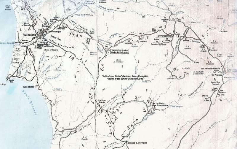
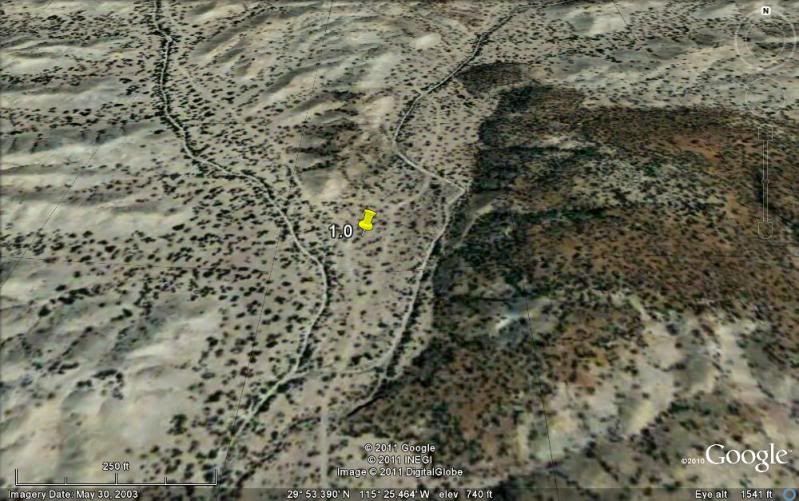
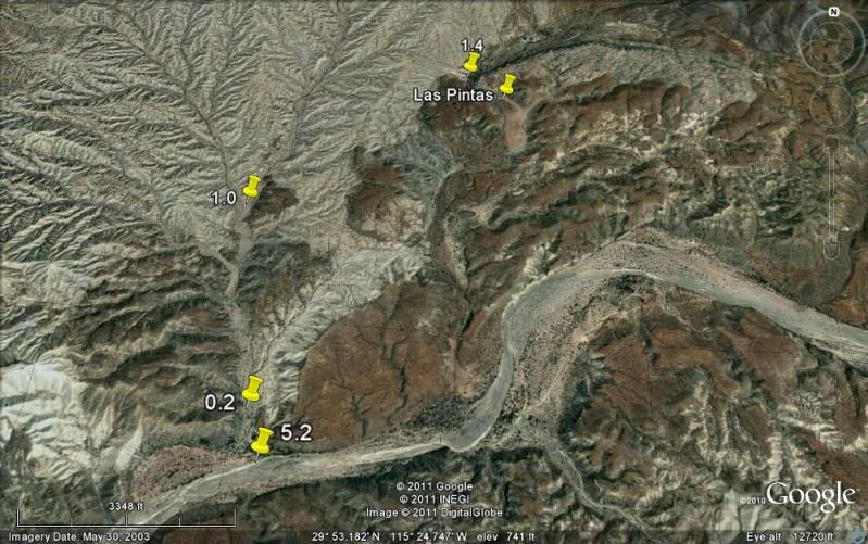
Here is the larger part of the map with mileages from last Sept.:
Here is what I suggest... allow as much time as possible to explore both the lower and upper Las Pintas site. It is like Tom Sawyers Island at
Disneyland with caves, narrow passages, lots of hidden stuff. It was an Indian playground for sure!
Go in the normal or easy way... that is the south road that goes up the wide Arroyo San Fernando valley past 'Malvar' (a couple of abandoned ranch
houses and junk cars). The left turn at Mile 5.2 is faint and is the only place you will get some brush contact. 0.2 mile is the right fork to Las
Pintas... You will return to this point to drive up to the top of Las Pintas.
When you arrive you will need to figure how to get into the boulder cave, which is right in front of you, but the flash flood of Jan. 2010 changed
things and I found a new way in over the boulder on the left. You guys will figure it out. Once inside the big room cave, note all the petros on the
walls and cielings... next crawl to one of the narrow passges and find your way up to the waterfall... Lots of fossils in the boulders...
After a hour or two of playing in the lower end (and you can hike up to the top, a trail is on the right side of the boulder field)... you can drive
up to the top end where lots more petros await you. We were running out of daylight, so you will see more! The north road back out, from the top is
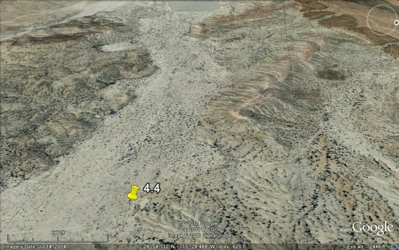
more of a Jeep trail and the only fork (Mile 4.4) is a left... We went right and that goes over to the San Vicente river valley and the wrong way. It
is muy dusty in here... as Baja is famous for! Once you are back on the graded Punta San Carlos road it is a fast trip back to El Rosario with many
Taco stands, restaurants, and Baja Cactus or Motel Turista for comfortable beds!
|
|
|
David K
Honored Nomad
Posts: 65563
Registered: 8-30-2002
Location: San Diego County
Member Is Offline
Mood: Have Baja Fever
|
|
Ken, I just made 12 satellite image maps of the road to Las Pintas from Hwy. 1 so you can SEE IT before you DRIVE IT! 
Do you want them in this thread or in a seperate thread?
|
|
|
Ken Cooke
Elite Nomad
Posts: 8971
Registered: 2-9-2004
Location: Riverside, CA
Member Is Offline
Mood: Pole Line Road postponed due to injury
|
|
Include them here!
| Quote: | Originally posted by David K
Ken, I just made 12 satellite image maps of the road to Las Pintas from Hwy. 1 so you can SEE IT before you DRIVE IT!
Do you want them in this thread or in a seperate thread? |
I'd like to see them. This sounds interesting.  Fire away.. Fire away..
|
|
|
David K
Honored Nomad
Posts: 65563
Registered: 8-30-2002
Location: San Diego County
Member Is Offline
Mood: Have Baja Fever
|
|
Map and images of road points to Las Pintas

Images facing direction of travel:
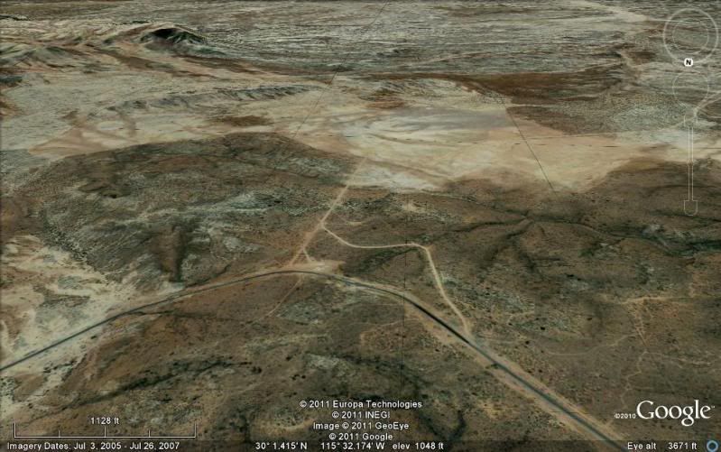
Leave Hwy. 1... north fork is near Km. 80 at wide clearing and south fork in near Km. 81, on the curve.
Older road coming 14 miles from El Rosario joins here (this offers an alternate route back and is not maintained or totally graded).
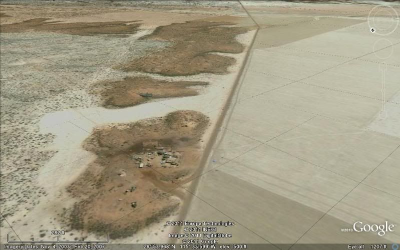
Rancho on hill next to road 'Emiliano Zapata' on map.
Just under 2 miles from Emiliano Zapata see road(s) go to the left... these are the alternate route to/ from Las Pintas you may be returning on.
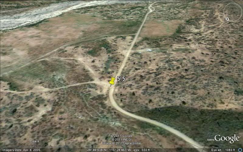
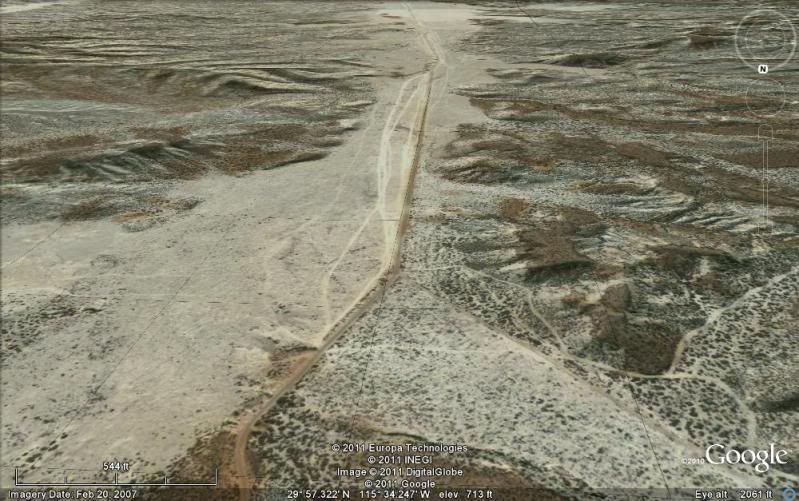
After enterining a cardon cactus area, the Las Pintas road turns left off the main (Punta San Carlos) road. If passed, you will drive by ranch house
on right and a second Las Pintas road can be taken... any further you will cross Arroyo San Fernando (turn back).

5.2 miles up Arroyo San Fernando, the Las Pintas road turns left into a side arroyo. Some brush may contact your Jeeps here.
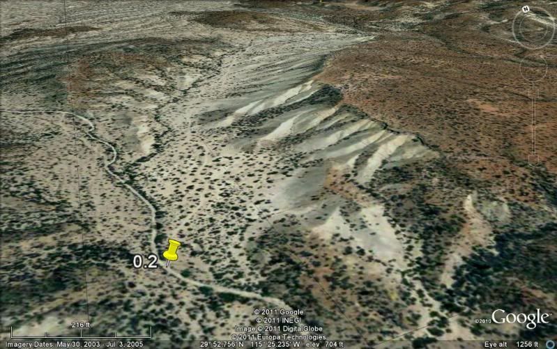
Just 2/10 a mile more and take right fork out of small arroyo.
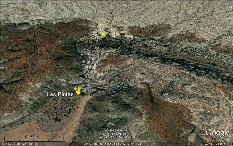
In 1.8 miles arrive bottom of Las Pintas. Explore! When ready, return to small arroyo and turn right (north) to drive to top of Las Pintas (fun Jeep
trail). See pin 1.4 which is top parking area.
1.0 mile up the small arroyo is the fork (right) to Las Pintas top (1.4 miles). Return to this point to leave area... and if desired, take the less
used, north road back.
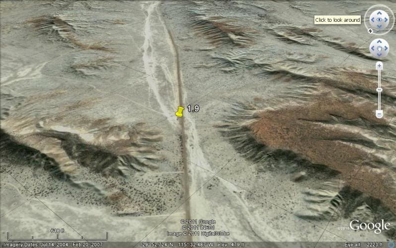
Here is a high view (north at top) to orient yourself to the Las Pintas area. Compare to map.
On the north road heading west, stay straight/left at this fork. We took the right fork for a mile and ended up in Arroyo San Vicente valley heading
northeast.
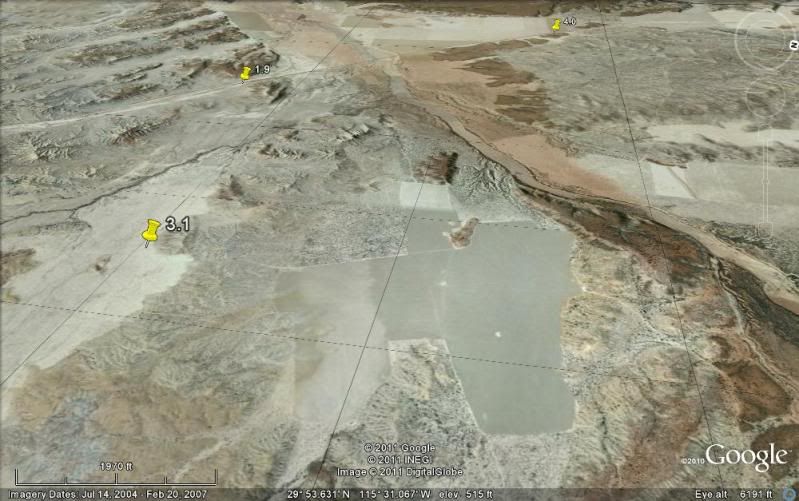
Approx. 3.1 miles from the last fork we turned right for the last 1.8 miles to the San Carlos road (at pin 1.9 or nearby). I don't see the exact road
we used last September in these 4-7 year old images.
Enjoy one of Baja's great places!
|
|
|
wessongroup
Platinum Nomad
Posts: 21152
Registered: 8-9-2009
Location: Mission Viejo
Member Is Offline
Mood: Suicide Hot line ... please hold
|
|
You're getting pretty good with the Google maps... DK.. about the only thing which would improve... a better feed from Google... thanks for all the
work...
It gets to be fun using that Google earth.. an amazing feat of technology... that is for free... plus some of the add on stuff one can down load too..
|
|
|
David K
Honored Nomad
Posts: 65563
Registered: 8-30-2002
Location: San Diego County
Member Is Offline
Mood: Have Baja Fever
|
|
Thanks... flying over is fun, but what really rocks is to get the GPS from your mouse pointer, then going in person to see what it looks (and feels)
like!
|
|
|
wessongroup
Platinum Nomad
Posts: 21152
Registered: 8-9-2009
Location: Mission Viejo
Member Is Offline
Mood: Suicide Hot line ... please hold
|
|
Ditto's...
|
|
|
Ken Cooke
Elite Nomad
Posts: 8971
Registered: 2-9-2004
Location: Riverside, CA
Member Is Offline
Mood: Pole Line Road postponed due to injury
|
|
| Quote: | Originally posted by wessongroup
You're getting pretty good with the Google maps... DK.. |
I love it. Thanks again, David!
|
|
|
David K
Honored Nomad
Posts: 65563
Registered: 8-30-2002
Location: San Diego County
Member Is Offline
Mood: Have Baja Fever
|
|
Have fun Ken!
|
|
|
bajalou
Ultra Nomad
Posts: 4459
Registered: 3-11-2004
Location: South of the broder
Member Is Offline
|
|
What's you're latest schedule Ken?
Wouldn't mind meeting up with you're group again.
No Bad Days
\"Never argue with an idiot. People watching may not be able to tell the difference\"
\"The trouble with doing nothing is - how do I know when I\'m done?\"
Nomad Baja Interactive map
And in the San Felipe area - check out Valle Chico area |
|
|
Ken Cooke
Elite Nomad
Posts: 8971
Registered: 2-9-2004
Location: Riverside, CA
Member Is Offline
Mood: Pole Line Road postponed due to injury
|
|
| Quote: | Originally posted by bajalou
What's you're latest schedule Ken?
Wouldn't mind meeting up with you're group again. |
Thanks, Lou! I believe that we will drive into S.F. at approximately 6 p.m. on the 23rd. We would be happy to grab a bite to eat before heading
south to Percebu.
|
|
|
bajalou
Ultra Nomad
Posts: 4459
Registered: 3-11-2004
Location: South of the broder
Member Is Offline
|
|
Let me know where and I'll see you then----
No Bad Days
\"Never argue with an idiot. People watching may not be able to tell the difference\"
\"The trouble with doing nothing is - how do I know when I\'m done?\"
Nomad Baja Interactive map
And in the San Felipe area - check out Valle Chico area |
|
|
BajaBlanca
Select Nomad
Posts: 13247
Registered: 10-28-2008
Location: La Bocana, BCS
Member Is Offline
|
|
If I can convince Les, can we come too ????? Meet up at Catavina or across the street for lunch on the 28th April, right ??
|
|
|
Ken Cooke
Elite Nomad
Posts: 8971
Registered: 2-9-2004
Location: Riverside, CA
Member Is Offline
Mood: Pole Line Road postponed due to injury
|
|
| Quote: | Originally posted by BajaBlanca
If I can convince Les, can we come too ????? Meet up at Catavina or across the street for lunch on the 28th April, right ?? |
I'm having 2nd thoughts about the "Loncheria" in Cataviña.. Something Mtn. Goat said, and I remember there was no running water anywhere to be found.
Yech!
|
|
|
David K
Honored Nomad
Posts: 65563
Registered: 8-30-2002
Location: San Diego County
Member Is Offline
Mood: Have Baja Fever
|
|
| Quote: | Originally posted by Ken Cooke
| Quote: | Originally posted by BajaBlanca
If I can convince Les, can we come too ????? Meet up at Catavina or across the street for lunch on the 28th April, right ?? |
I'm having 2nd thoughts about the "Loncheria" in Cataviña.. Something Mtn. Goat said, and I remember there was no running water anywhere to be found.
Yech! |
Get tacos at Rancho Santa Ynez!
|
|
|
BajaBlanca
Select Nomad
Posts: 13247
Registered: 10-28-2008
Location: La Bocana, BCS
Member Is Offline
|
|
Let's eat at Catavina ...... meaning at the la pinta hotel. where is the rancho you guys mention as an alternative place to eat ??
[Edited on 4-18-2011 by BajaBlanca]
|
|
|
Ken Cooke
Elite Nomad
Posts: 8971
Registered: 2-9-2004
Location: Riverside, CA
Member Is Offline
Mood: Pole Line Road postponed due to injury
|
|
| Quote: | Originally posted by David K
Get tacos at Rancho Santa Ynez! |
They make good food? 
|
|
|
David K
Honored Nomad
Posts: 65563
Registered: 8-30-2002
Location: San Diego County
Member Is Offline
Mood: Have Baja Fever
|
|
| Quote: | Originally posted by Ken Cooke
| Quote: | Originally posted by David K
Get tacos at Rancho Santa Ynez! |
They make good food? |
They have been feeding Baja travelers long before Highway One was even dreamed about!
I guess my numerous photos and posts of us eating there have escaped your eyes...?
Here's a few... also a nice camping area, running water for toilets and showers, nice bunk rooms for over nighting... Hosts are Oscar and Matilda...
Don't you check in with them before you do a run into Santa Maria? Burritos are yummy before that drive!
1982:

1999:


2001:

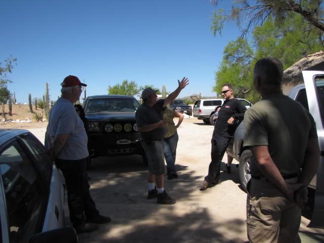
The Viva Baja Van and P.O.T. (Poor Old Truck) gang at Rancho Santa Ynez, for lunch. Seated: Sarah, Miguelito, Chris, Mary Ann, Travelpearl, Desert
Rat. Standing: David Eidell, El Camote, Mike Humfreville. July 2, 2001
2003:
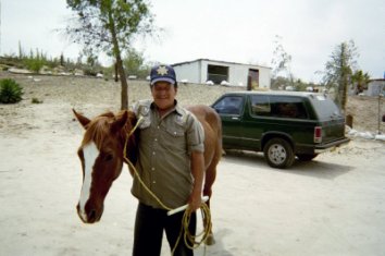

Oscar is showing us a trick he taught 'Rayo' ('Lightning').
2007:

Blanche and Elizabeth chat with ranch managers Matilda ad Oscar. Good tacos and cold drinks can be ordered here before the mission voyage begins.
Santa Ynez (Santa Ines) is a mile south of Cataviña and a mile off the highway. Here find meals, rooms, and camping.
2010:
(last photo from BajaTripper seems to be showing me telling the group about how steep the Widowmaker grade is! LOL )
[Edited on 4-18-2011 by David K]
|
|
|
| Pages:
1
2
3
4
5 |


