| Pages:
1
2
3
..
5 |
Ken Cooke
Elite Nomad

Posts: 8971
Registered: 2-9-2004
Location: Riverside, CA
Member Is Offline
Mood: Pole Line Road postponed due to injury
|
|
Baja Grande planning
In 2007, the Baja Grande group tried to reach the La Turquesa to Hwy 1 route, but we could not locate this elusive path. So, after following
the extensive research performed by David K and TW, we're going to give it another try - 3 1/2 yrs. later!

2011 Baja Grande Schedule-
23/24 de Abril - Rancho Punta Estrella
25/26 de Abril - Gonzaga Bay
27 de Abril - Bay of LA
28 de Abril - Mission Sta. Maria
29 de Abril - El Rosario
30 de Abril - Return to USA
April 24th will be a day to visit Shell Island and maybe a late afternoon trip into San Felipe for dinner and shopping.
April 26th will allow for a full day of 4 wheeling along the La Turquesa Mine Trail: http://vivabaja.com/207/
All in all, I am happy with this revamped schedule which will allow for us to concentrate on the good stuff! 
|
|
|
racheldarlin
Junior Nomad
Posts: 69
Registered: 9-30-2010
Member Is Offline
|
|
Ken,
It looks like a great trip. I will look forward to your trip report. Any new for your rig?
I am currently exploring for a new and shorter route into S. Maria but have found nothing yet for 4 wheels.
PS: I hope the weather is good for you. It has not been typical Baja this year.
|
|
|
David K
Honored Nomad
Posts: 65563
Registered: 8-30-2002
Location: San Diego County
Member Is Offline
Mood: Have Baja Fever
|
|
| Quote: | Originally posted by racheldarlin
Ken,
It looks like a great trip. I will look forward to your trip report. Any new for your rig?
I am currently exploring for a new and shorter route into S. Maria but have found nothing yet for 4 wheels.
PS: I hope the weather is good for you. It has not been typical Baja this year. |
Only one way in or out with four wheels... 8 months ago:
http://community-2.webtv.net/vivabaja/msm2010/
By foot there is a trail over the mountain from Hwy. 1 near San Ignacito (Puerto La Mision trail) and then there is the EL CAMINO REAL that comes up
the mountain from near Gonzaga: http://vivabaja.com/1103 (photos of the other end near Santa Maria on the 2010 trip page.
|
|
|
David K
Honored Nomad
Posts: 65563
Registered: 8-30-2002
Location: San Diego County
Member Is Offline
Mood: Have Baja Fever
|
|
| Quote: | Originally posted by Ken Cooke
In 2007, the Baja Grande group tried to reach the La Turquesa to Hwy 1 route, but we could not locate this elusive path. So, after following
the extensive research performed by David K and TW, we're going to give it another try - 3 1/2 yrs. later!
2011 Baja Grande Schedule-
23/24 de Abril - Rancho Punta Estrella
25/26 de Abril - Gonzaga Bay
27 de Abril - Bay of LA
28 de Abril - Mission Sta. Maria
29 de Abril - El Rosario
30 de Abril - Return to USA
April 24th will be a day to visit Shell Island and maybe a late afternoon trip into San Felipe for dinner and shopping.
April 26th will allow for a full day of 4 wheeling along the La Turquesa Mine Trail: http://vivabaja.com/207/
All in all, I am happy with this revamped schedule which will allow for us to concentrate on the good stuff! |
Why Rancho Punta Estrella instead of Rancho Percebu? (I presume you are not camping on the island because you want toilets and shower facilities?)
|
|
|
Ken Cooke
Elite Nomad
Posts: 8971
Registered: 2-9-2004
Location: Riverside, CA
Member Is Offline
Mood: Pole Line Road postponed due to injury
|
|
| Quote: | | Originally posted by David KWhy Rancho Punta Estrella instead of Rancho Percebu? (I presume you are not camping on the island because you
want toilets and shower facilities?) |
25 mile Off-Road Racing Course
Minutes to Shell Island and across the street from Valley of the Giants
Percebu has an "unkept" look as well...
|
|
|
TMW
Select Nomad
Posts: 10659
Registered: 9-1-2003
Location: Bakersfield, CA
Member Is Offline
|
|
David K you should come down for this event on the 26th. Either as a witness, scout, field hand, road builder, rock mover, Jeep fixer, supervisor or
cheerleader. Or you and I can set back and watch with a cold one. Bring a tow strap in case one of the Jeeps needs pulled out, just kidding Ken. Ken's
Jeep pulls Toyotas just fine.
|
|
|
BAJACAT
Ultra Nomad
Posts: 2902
Registered: 11-21-2005
Location: NATIONAL CITY, CA
Member Is Offline
|
|
kEN im still working on meeting the group on the 28th to follow you guys to SMM, site. I will let you know ahead of time.. TW are you comming?
BAJA IS WHAT YOU WANTED TO BE, FUN,DANGEROUS,INCREDIBLE, REMOTE, EXOTIC..JUST GO AND HAVE FUN.....
|
|
|
Ken Cooke
Elite Nomad
Posts: 8971
Registered: 2-9-2004
Location: Riverside, CA
Member Is Offline
Mood: Pole Line Road postponed due to injury
|
|
| Quote: | Originally posted by BAJACAT
kEN im still working on meeting the group on the 28th to follow you guys to SMM, site. I will let you know ahead of time.. TW are you comming?
|
That will be great, Jose! That morning, we will be driving north from L.A. Bay. We will eat lunch at the loncheria in Cataviña across the street
from the La Pinta Hotel. From there, we will air down our tires and disconnect our front swaybars at Rancho Santa Ynez. We plan leaving for the
Mission at 1 p.m. on the 28th.
|
|
|
TMW
Select Nomad
Posts: 10659
Registered: 9-1-2003
Location: Bakersfield, CA
Member Is Offline
|
|
I'll be down on the 26th for the mine run. Jose if you are coming I'll do the SMM run too. Don't know if I'll go to LA Bay or run up to El Marmol and
run back into La Olividada and explore the mine area.
|
|
|
BAJACAT
Ultra Nomad
Posts: 2902
Registered: 11-21-2005
Location: NATIONAL CITY, CA
Member Is Offline
|
|
Ok sounds good..and I only have plans to go to SMM and then back to San Diego..
@ this point I think I need new tires but don't know.the Run it's going to be on a thursday so I will have to take 2 days off, maybe I will stay a
extra day in El Rosario.. maybe we can do a run to las PINTAS...
Ken if I go I will leave the SD area around 5:00 am..on thursday and have lunch with you guys in Catavinä..
ps TW what mine run???
[Edited on 3-7-2011 by BAJACAT]
BAJA IS WHAT YOU WANTED TO BE, FUN,DANGEROUS,INCREDIBLE, REMOTE, EXOTIC..JUST GO AND HAVE FUN.....
|
|
|
Ken Cooke
Elite Nomad
Posts: 8971
Registered: 2-9-2004
Location: Riverside, CA
Member Is Offline
Mood: Pole Line Road postponed due to injury
|
|
| Quote: | Originally posted by BAJACAT
Ken if I go I will leave the SD area around 5:00 am..on thursday and have lunch with you guys in Catavinä..
[Edited on 3-7-2011 by BAJACAT] |
What is Las Pintas??? Is it a 4WD Trail we could run??
|
|
|
David K
Honored Nomad
Posts: 65563
Registered: 8-30-2002
Location: San Diego County
Member Is Offline
Mood: Have Baja Fever
|
|
| Quote: | Originally posted by Ken Cooke
| Quote: | Originally posted by BAJACAT
Ken if I go I will leave the SD area around 5:00 am..on thursday and have lunch with you guys in Catavinä..
[Edited on 3-7-2011 by BAJACAT] |
What is Las Pintas??? Is it a 4WD Trail we could run??
|
Just where are you when I do my trip reports Ken???
Here is a web page from a trip a few years ago: http://vivabaja.com/pintas
Here is our last trip to Baja (Sept. 2010) to LAS PINTAS: http://forums.bajanomad.com/viewthread.php?tid=47965
Make sure to see Part 2 as well!
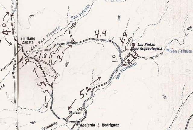
This map of the area shows the main road (southern road via Malvar' in and the lesser road to the north. The lesser road, including the run to the top
side of Las Pintas is a 4WD track... I used a little low range in there, too.
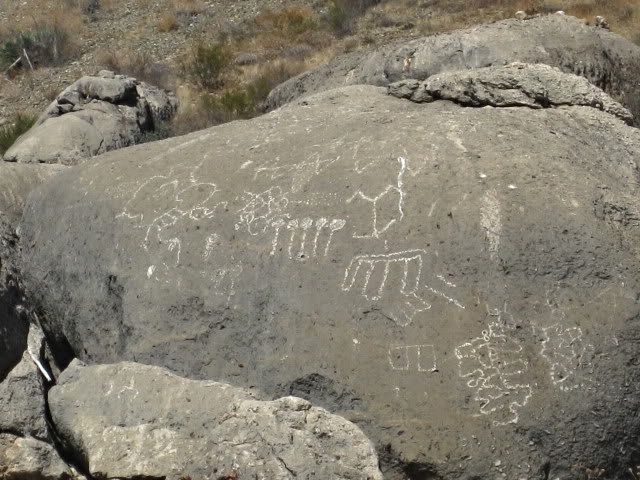
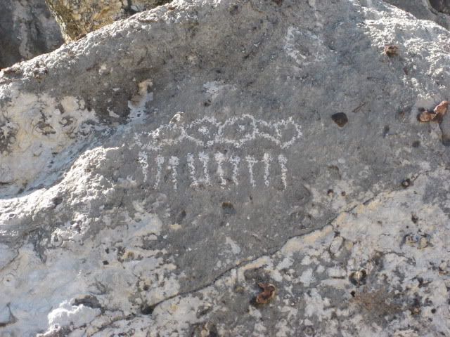
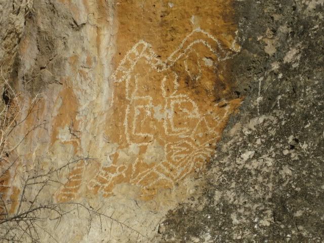
You can also read about Las Pintas in the BAJABOUND.COM newsletter!
[Edited on 3-8-2011 by David K]
|
|
|
Ken Cooke
Elite Nomad
Posts: 8971
Registered: 2-9-2004
Location: Riverside, CA
Member Is Offline
Mood: Pole Line Road postponed due to injury
|
|
| Quote: | | Originally posted by BAJACAT maybe we can do a run to las PINTAS...[Edited on 3-7-2011 by BAJACAT] |
Jose - Would you be willing to lead our group to Las Pintas??? I have photos from David K, but it would be great to visit with someone who has
already been there.
-Ken
|
|
|
BAJACAT
Ultra Nomad
Posts: 2902
Registered: 11-21-2005
Location: NATIONAL CITY, CA
Member Is Offline
|
|
| Quote: | Originally posted by Ken Cooke
| Quote: | | Originally posted by BAJACAT maybe we can do a run to las PINTAS...[Edited on 3-7-2011 by BAJACAT] |
Jose - Would you be willing to lead our group to Las Pintas??? I have photos from David K, but it would be great to visit with someone who has
already been there.
-Ken |
Ken I have never been inLas Pintas, thats why I wanted to go there, maybe TW knows the way.
BAJA IS WHAT YOU WANTED TO BE, FUN,DANGEROUS,INCREDIBLE, REMOTE, EXOTIC..JUST GO AND HAVE FUN.....
|
|
|
Ken Cooke
Elite Nomad
Posts: 8971
Registered: 2-9-2004
Location: Riverside, CA
Member Is Offline
Mood: Pole Line Road postponed due to injury
|
|
| Quote: | Originally posted by BAJACAT
| Quote: | Originally posted by Ken Cooke
| Quote: | | Originally posted by BAJACAT maybe we can do a run to las PINTAS...[Edited on 3-7-2011 by BAJACAT] |
Jose - Would you be willing to lead our group to Las Pintas??? I have photos from David K, but it would be great to visit with someone who has
already been there.
-Ken |
Ken I have never been inLas Pintas, thats why I wanted to go there, maybe TW knows the way.
|
We can just study the maps and drive there from Hwy 1.
|
|
|
David K
Honored Nomad
Posts: 65563
Registered: 8-30-2002
Location: San Diego County
Member Is Offline
Mood: Have Baja Fever
|
|
You have me as a guide, on paper... just print out the directions and note your mileages or use a GPS. Remember, all roads in Baja go somewhere...
somewhere really cool!
|
|
|
mtgoat666
Platinum Nomad
Posts: 21091
Registered: 9-16-2006
Location: San Diego
Member Is Offline
Mood: Hot n spicy
|
|
| Quote: | Originally posted by Ken Cooke
We will eat lunch at the loncheria in Cataviña across the street from the La Pinta Hotel. |
not very good food, and i got the runs after eating there.
suggest you pack a lunch or eat at la pinta.
|
|
|
Ken Cooke
Elite Nomad
Posts: 8971
Registered: 2-9-2004
Location: Riverside, CA
Member Is Offline
Mood: Pole Line Road postponed due to injury
|
|
| Quote: | Originally posted by mtgoat666
| Quote: | Originally posted by Ken Cooke
We will eat lunch at the loncheria in Cataviña across the street from the La Pinta Hotel. |
not very good food, and i got the runs after eating there.
suggest you pack a lunch or eat at la pinta. |
I don't eat Beef, Pork, Cheese products, and I avoid Chicken unless absolutely necessary. What did you order?
|
|
|
TMW
Select Nomad
Posts: 10659
Registered: 9-1-2003
Location: Bakersfield, CA
Member Is Offline
|
|
He ate tin cans, probably rusty ones.
|
|
|
TMW
Select Nomad
Posts: 10659
Registered: 9-1-2003
Location: Bakersfield, CA
Member Is Offline
|
|
I've never been to the site.
Here is Davids directions:
DIRECTIONS
Highway 1, southward from El Rosario 14.6 miles (between Km. 80-81), turn right at the left curve. GPS: 30°01.59', 115°32.05' (Map datum set to 'NAD27
Mexico')
Go 17.4 miles on the good graded dirt road to a single track road going left. If passed, just ahead is a ranch house on the right and there is a
second left road that joins the first. Set odometer to '0.0'. GPS: 29°49.64', 115°28.42'.
Pass ranch houses ('Malvar') and make an 'S' turn right, into Arroyo San Fernando. You soon will be reach a (possibly) closed gate at Mile 3.5. Always
re-close any gate after you pass through.
Mile 5.2, (GPS: 29°52.53', 115°25.22') turn LEFT off of Arroyo San Fernando road, and follow a small side arroyo. Brush may scratch your vehicle in
here.
Mile 5.4, (GPS: 29°52.69', 115°25.26') turn RIGHT, out of small arroyo and cross low divide to small valley.
Mile 7.2 LAS PINTAS parking area. GPS: 29°53.90', 115°24.48', elev. 755'. You are 24.6 miles from Highway 1 and 39.2 miles from El Rosario's Baja
Cactus Motel and Pemex gas station, per my odometer.
Trail to the right of the boulders is the best way to the top, then cross over to other side and try the more difficult trail to get back down.
Straight into the boulders from the parking area are tunnels, passages, and boulder shelters. ENJOY!
|
|
|
| Pages:
1
2
3
..
5 |


