| Pages:
1
2
3
4 |
TMW
Select Nomad
      
Posts: 10659
Registered: 9-1-2003
Location: Bakersfield, CA
Member Is Offline
|
|
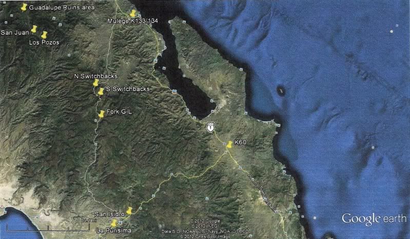
Here is the route from Google Earth. I traced it as a path. The marker for Fork G L is the junction where Mulegena backed up and went left. In the
Almanac it would be page 15 along the Guajademi arroyo between Las Lagunitas on the left and Tinaja de San Pedro on the right, F7. The switchbacks are
marked and on page 15 to the left of El Bateque. The closest cross marks in the Almanac are F6. The Almanac is not very accurate on the actual
locations.
|
|
|
KurtG
Super Nomad
   
Posts: 1211
Registered: 1-27-2004
Location: California Central Coast
Member Is Offline
Mood: Press On Regardless!!
|
|
| Quote: | Originally posted by Mulegena
| Quote: | Originally posted by David K
| Quote: | Originally posted by Mulegena
It was... about 65 miles total from La Purisima to Mulege. Absolutely jaw-dropping gorgeous country and a glimpse of Baja backcountry that folks just
don't usually see... |
EL LLANO is up and west of SAN JOSE DE MAGDALENA... But, that isn't on any road from La Purisima to Mulege... so a different El Llano...
How did you arrive into Mulege, from what direction, what road... ?? Did you turn back at Paso Hondo... or continue driving north towards Mulege...
The only road/ pass is through Guajademi. Other routes west from Mulege pass San Miguel and come out north of San Juanico (Scorpion Bay) or pass
Mision Guadalupe and on to the Pacific south of San Ignacio. |
Thanks for responding, David, and a big thanks
for the detailed maps which I've studied and re-studied.
It appears we were on the correct road.
To clarify, remember I'm describing the journey south-to-north, La Purisima to Mulege: Coming out of Paso Hondo we did take the left fork
signed "El Llano" after turning around from Guajademi (which is just east of the main road and isn't a town-proper but a collection of isolated
sheep ranches, btw).
We climbed up onto a high plateau and I thought we'd reached Tibet.
Then we came to a Z-track, very serious percentage, down-grade which opened up onto a high plateau which had about 5-6 dirt-depressions
(tajos/re-pressas) for collecting seasonal rain. Slowly down, cross through the flat valley, then another Z-track up to the plateau on the other side.
Then through a ranch gate and down a big mountain.
Went through another ranch gate and passed two signs to "Rancho El Llanito" and another hour or so to come into the south-west Mulege river-wash area.
The sign to Rancho El Trinidad and the cave paintings was on our left and we came into town on Ice House Road.
So, yes, the road from Mulege to La Purisima via Guajademi is passable and even machine-graded where it can be. Where its not graded the road
is steep and large rocks.
We got through easily in our 1988 Chevy s10 4x4 pickup. I took lots of photos, and I'd love to do a trip report on a separate thread.
|
I know where that fork is and if you had gone right it deadends. At least that was the case a few years ago. The "steep and large rocks" were what
turned us around in October but I think it will be easier going down than the north to south direction we were going. Thanks for the info and when we
go there again I will give a report. That first "Z-track" is where the road ended the first time I tried to go through.
|
|
|
elfbrewery
Nomad
 
Posts: 349
Registered: 12-25-2006
Member Is Offline
|
|
Going from Mulege south, I've been as far as David K's 12 (cave with springs up beyond rancho along arroyo). How do you get from 12 to 13, though??
|
|
|
KurtG
Super Nomad
   
Posts: 1211
Registered: 1-27-2004
Location: California Central Coast
Member Is Offline
Mood: Press On Regardless!!
|
|
| Quote: | Originally posted by elfbrewery
Going from Mulege south, I've been as far as David K's 12 (cave with springs up beyond rancho along arroyo). How do you get from 12 to 13, though??
|
From my experience I don't think that is the exact route. I think the route shown on that map is the old mule trail and the current road is slightly
to the West and as I mentioned earlier is not on the map. Also it is possible, likely IMO, that the current route is more recent than the Google
Earth image for that area. Again, I will do GPS on our trip there in a little more than two weeks and pass it along for those who want to explore
that beautiful area.
|
|
|
David K
Honored Nomad
        
Posts: 65453
Registered: 8-30-2002
Location: San Diego County
Member Is Offline
Mood: Have Baja Fever
|
|
OK... TW was a big help as well... I got confused when there was talk of going back to Paso Hondo to the left fork... It seems the fork is just south
of Guajademi and detours around it. Thanks TW and Mulegena and Kurt!
elfbrewery, that is the EL CAMINO REAL route highlighted on the map and in the satellite images... It seems that the auto road goes over that mountain
to the right (west) of the Camino Real route... and rejoins ECR just sout of Guajademi.. Great thing, Baja Nomad is!
|
|
|
KurtG
Super Nomad
   
Posts: 1211
Registered: 1-27-2004
Location: California Central Coast
Member Is Offline
Mood: Press On Regardless!!
|
|
| Quote: | Originally posted by David K
OK... TW was a big help as well... I got confused when there was talk of going back to Paso Hondo to the left fork... It seems the fork is just south
of Guajademi and detours around it. Thanks TW and Mulegena and Kurt!
elfbrewery, that is the EL CAMINO REAL route highlighted on the map and in the satellite images... It seems that the auto road goes over that mountain
to the right (west) of the Camino Real route... and rejoins ECR just sout of Guajademi.. Great thing, Baja Nomad is! |
Another factor is the hurricanes of a few years ago changed the routes of the roads in the Mulege valley in some places so the maps can be a little
inacurate. David, what map dictum should I use when taking GPS readings there so that they can be used with the almanac?
|
|
|
David K
Honored Nomad
        
Posts: 65453
Registered: 8-30-2002
Location: San Diego County
Member Is Offline
Mood: Have Baja Fever
|
|
The Mexican Topos (Almanac) is at 'NAD27 Mexico'... however, the scale of the Almanac is not so great, that if you leave the GPS at the factory
setting (WGS84) you won't notice a change in position. If, however, you have a large scale topo map made in Mexico... then there may be a few hundred
feet difference.
|
|
|
TMW
Select Nomad
      
Posts: 10659
Registered: 9-1-2003
Location: Bakersfield, CA
Member Is Offline
|
|
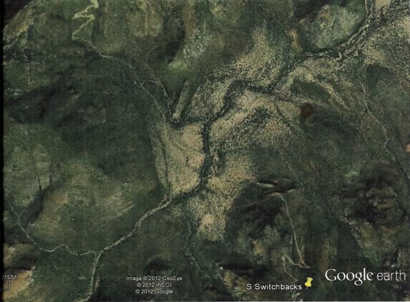
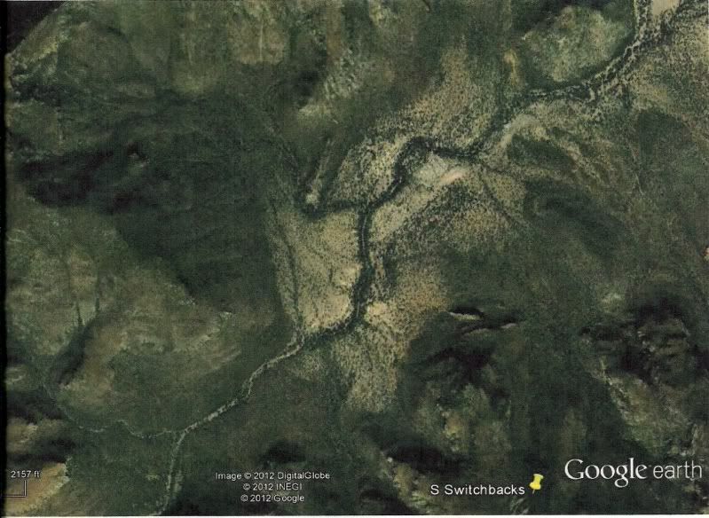
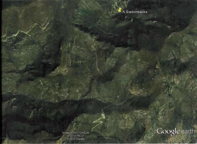
There is a lot of difference between 2006 and 2010. Appears someone has probably bladed the road and/or cut new road.
The Google Earth Image dated 2-13-2010 showing the south switchbacks.
Same image but from 2006.
Now the north switchbacks in 2010.
Same north switchback area from 2006.
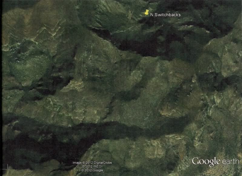
|
|
|
Mulegena
Super Nomad
   
Posts: 2412
Registered: 11-7-2006
Member Is Offline
|
|
Yes, I'm sure the route has changed a bit over the years.
I was really impressed with how the roads are kept up and repaired in spite of the extensive damage from the torrent of water brought by the
hurricanes over the last few years.
You'll find roadwork graders parked up on the mountainside in the foothills southwest of Mulege and will see new tracks cut around washed-out culverts
'way up in the mountains. Some of the areas which are prone to washout have been paved with cement. Other areas range from good-quality graded dirt
road to driving through large loose rock beds and boulder fields.
A note on boulders: The most-southerly of the 2 z-track switchbacks that cross the high plain is the most steep and boulder-strewn of all the passes.
We went down that grade from the Paso Hondo side in our pickup and don't think we'd try to go up from the Mulege side. For us, it'd take a beefier
truck than our Chevy s-10.
There's a sign for an available rural telephone in the pueblo of Paso Hondo, btw.
"Raise your words, not your voice. It's rain that grows flowers, not thunder." ~Rumi
"It's the mark of an educated mind to be able to entertain a thought without accepting it." ~ Aristotle
|
|
|
David K
Honored Nomad
        
Posts: 65453
Registered: 8-30-2002
Location: San Diego County
Member Is Offline
Mood: Have Baja Fever
|
|
Nice job with the Google Earth images Tom!!!   
|
|
|
KurtG
Super Nomad
   
Posts: 1211
Registered: 1-27-2004
Location: California Central Coast
Member Is Offline
Mood: Press On Regardless!!
|
|
| Quote: | Originally posted by Mulegena
A note on boulders: The most-southerly of the 2 z-track switchbacks that cross the high plain is the most steep and boulder-strewn of all the passes.
We went down that grade from the Paso Hondo side in our pickup and don't think we'd try to go up from the Mulege side. For us, it'd take a beefier
truck than our Chevy s-10.
There's a sign for an available rural telephone in the pueblo of Paso Hondo, btw. |
That is the cuesta where we went about halfway up and turned around. I suspected that it would be easier to come down it and am glad to hear that it
is the worst part, I was starting to feel like a wuss for turning back. In retrospect it was a rare display of common sense on my part. I am really
eager to revisit that area.
|
|
|
David K
Honored Nomad
        
Posts: 65453
Registered: 8-30-2002
Location: San Diego County
Member Is Offline
Mood: Have Baja Fever
|
|
| Quote: | Originally posted by KurtG
| Quote: | Originally posted by Mulegena
A note on boulders: The most-southerly of the 2 z-track switchbacks that cross the high plain is the most steep and boulder-strewn of all the passes.
We went down that grade from the Paso Hondo side in our pickup and don't think we'd try to go up from the Mulege side. For us, it'd take a beefier
truck than our Chevy s-10.
There's a sign for an available rural telephone in the pueblo of Paso Hondo, btw. |
That is the cuesta where we went about halfway up and turned around. I suspected that it would be easier to come down it and am glad to hear that it
is the worst part, I was starting to feel like a wuss for turning back. In retrospect it was a rare display of common sense on my part. I am really
eager to revisit that area. |
Not a wuss! 
Hey Kurt, there's nothing that a nice cold glass of orange juice won't cure... right? 
|
|
|
KurtG
Super Nomad
   
Posts: 1211
Registered: 1-27-2004
Location: California Central Coast
Member Is Offline
Mood: Press On Regardless!!
|
|
David,
I don't think OJ has ever tasted as good as when I was sick that day. Despite not feeling well I have no regrets about that Santa Maria trip, wanted
to go there for many years and hope to again.
Kurt
|
|
|
David K
Honored Nomad
        
Posts: 65453
Registered: 8-30-2002
Location: San Diego County
Member Is Offline
Mood: Have Baja Fever
|
|
It was great, wasn't it!!?? Poor Neal, but he likes being stuck in the desert! Great help from CG that weekend... Everyone was outstanding in his or
her own way.
|
|
|
Mulegena
Super Nomad
   
Posts: 2412
Registered: 11-7-2006
Member Is Offline
|
|
Not a wuss-- turning around in the midst of that ascent speaks volumes of some kick-a@@ driving skill.
We actually stopped half-way down and said...well, you can imagine what we said!... and I got out and walked down to the next elbow just to see if we
could make the descent which was kinda silly 'cause if we couldn't get down that grade we sure as heck weren't gonna be able to turn around and go
back up!!
I think quads or trucks hunkier than ours would be the best ticket.
Next would be dirt bikes or of course a burro or mule would be the bomb!
"Raise your words, not your voice. It's rain that grows flowers, not thunder." ~Rumi
"It's the mark of an educated mind to be able to entertain a thought without accepting it." ~ Aristotle
|
|
|
Blair
Junior Nomad

Posts: 63
Registered: 5-19-2010
Location: El Cajon Ca
Member Is Offline
Mood: Getting ready to go again
|
|
Thanks for everything folks, very impressive and invaluable info - read every word more than once. My take-away is yes it is doable, very worthwhile
and probably best done S to N. We will be on a group of 5 bikes on the peninsula from April 14 to the 23 going from San Ignacio to the cape and back.
I think this segment needs to be included.
Mulegena - you mentioned pics of your trip - id love to see them if you have time to post
TW - that comparison 06 to present very interesting - thanks
Kurt G - If you do do this segment (late march?) I would be very interested in LL's of your trip pics and commentary
David - Your website is very informative - Still going through it. Love your mission stuff and the old baja pics - esp the pics of the ruins in the
50's.
Blair in El Cajon
|
|
|
Blair
Junior Nomad

Posts: 63
Registered: 5-19-2010
Location: El Cajon Ca
Member Is Offline
Mood: Getting ready to go again
|
|
Oh and while were in the area....
Do any of you know what the name of this canyon is (red arrow)? We found it by accident 3 years ago and have been through there twice. Absolutely
beautiful area!
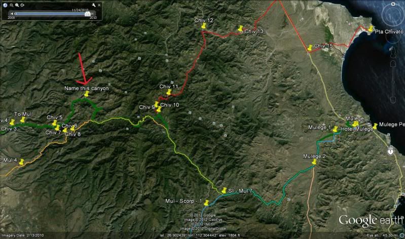
LOOKING NORTHWEST
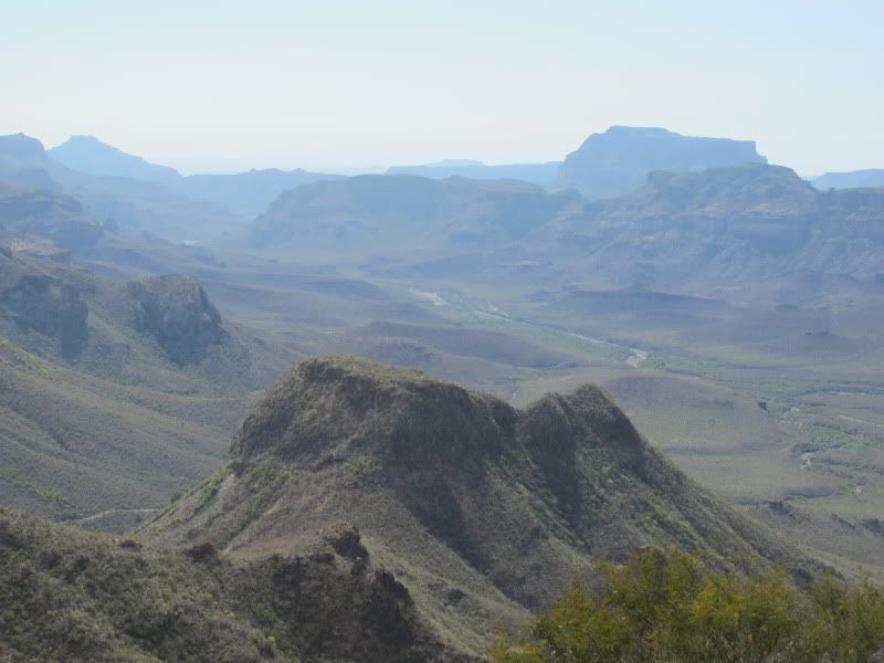
[Edited on 3-6-2012 by Blair]
Blair in El Cajon
|
|
|
KurtG
Super Nomad
   
Posts: 1211
Registered: 1-27-2004
Location: California Central Coast
Member Is Offline
Mood: Press On Regardless!!
|
|
| Quote: | Originally posted by Blair
Oh and while were in the area....
Do any of you know what the name of this canyon is (red arrow)? We found it by accident 3 years ago and have been through there twice. Absolutely
beautiful area!

LOOKING NORTHWEST

[Edited on 3-6-2012 by Blair] |
I have almost that exact same photo. If I am correct that is the road from San Juan de la Pila through Rancho San Pedro and coming out on the Mission
Guadalupe road to the east of where this photo was taken. The summit where the photo was shot is El Potrero. Spectacular views in both directions.
A number of years ago I went through that road twice to where it comes out on the Laguna San Ignacio road. To the east it looks like you went by
Mission Guadalupe and then out through San Jose de Magdalena, you can also turn right (south) at that intersection and go to Mulege. I love it back
there!
|
|
|
TMW
Select Nomad
      
Posts: 10659
Registered: 9-1-2003
Location: Bakersfield, CA
Member Is Offline
|
|
I would be very interested in a trip report on this Guajademi Canyon road as I may do it coming back from the NORRA race in May. It would add an extra
treat to the Agua Verde and Timbabichi trip.
|
|
|
KurtG
Super Nomad
   
Posts: 1211
Registered: 1-27-2004
Location: California Central Coast
Member Is Offline
Mood: Press On Regardless!!
|
|
| Quote: | Originally posted by TW
I would be very interested in a trip report on this Guajademi Canyon road as I may do it coming back from the NORRA race in May. It would add an extra
treat to the Agua Verde and Timbabichi trip. |
We plan to go through there around 3/20-21 and will post a report. Hope you will do the same for both the routes you have planned. I've been to Agua
Verde and would like to do the back way out to the south. We have to be a little careful with the Explorer, while it is the Bauer Ed. with 16" wheels
the underside is not well protected and limits some of the places we can go. And David, don't tell us to get a Toyota, the Explorer has a feature we
can't duplicate in any new vehicle. It is paid for!
|
|
|
| Pages:
1
2
3
4 |

