| Pages:
1
2
3
4
5 |
David K
Honored Nomad

Posts: 65581
Registered: 8-30-2002
Location: San Diego County
Member Is Offline
Mood: Have Baja Fever
|
|
2012
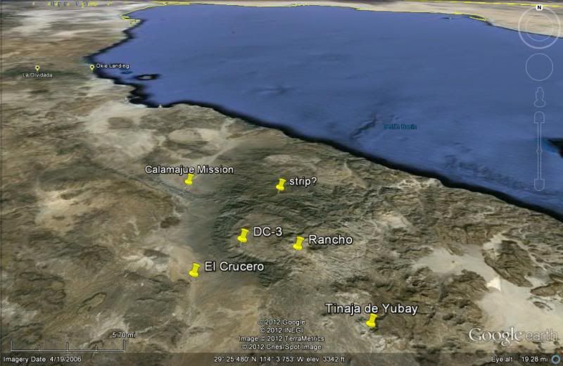
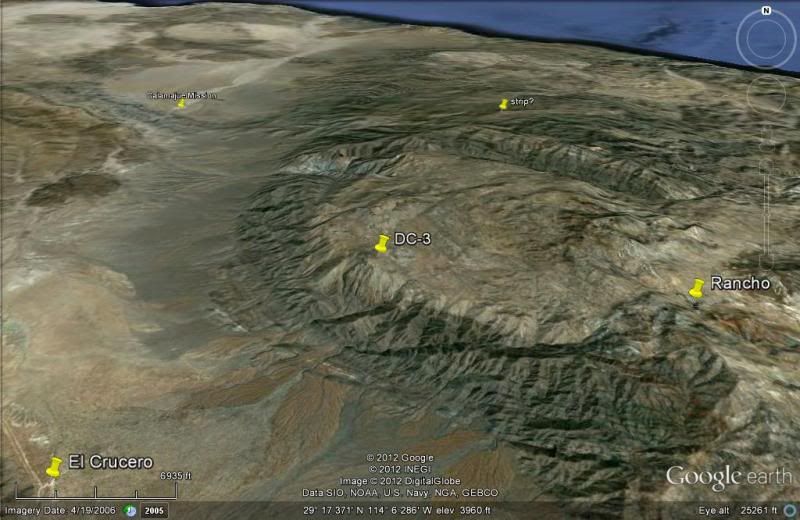
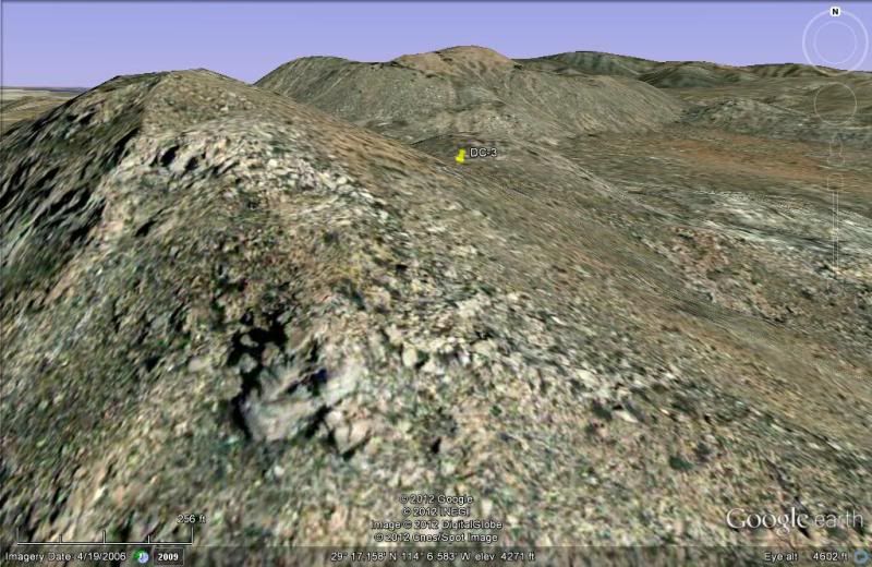
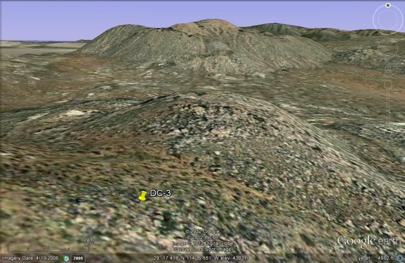
Here are 4 Google Earth images showing the DC-3 site, and the mystery airstrip is added for relationship in the first image... as well as Yubay, El
Crucero, Mision de Calamajue:
|
|
|
David K
Honored Nomad
Posts: 65581
Registered: 8-30-2002
Location: San Diego County
Member Is Offline
Mood: Have Baja Fever
|
|
The rancho is about 3 miles from the DC-3 site.
|
|
|
Barry A.
Select Nomad
Posts: 10007
Registered: 11-30-2003
Location: Redding, Northern CA
Member Is Offline
Mood: optimistic
|
|
David--------this "Rancho"----is it active, and accessible by 4-wheel vehicle??? I think this is a new one on me, this "rancho"---I don't remember
ever hearing about it before.
Who reported this rancho, and when? (do you know?)
Barry
|
|
|
David K
Honored Nomad
Posts: 65581
Registered: 8-30-2002
Location: San Diego County
Member Is Offline
Mood: Have Baja Fever
|
|
| Quote: | Originally posted by Barry A.
David--------this "Rancho"----is it active, and accessible by 4-wheel vehicle??? I think this is a new one on me, this "rancho"---I don't remember
ever hearing about it before.
Who reported this rancho, and when? (do you know?)
Barry |
The rancho has been therse at least since 2001... I drove on his road to a locked gate (which was many miles before the ranch)... BillB parked at the
gate and waited until the owner showed up, who invited him on in. The ranch is near the headwater to Salsipuedes... a short side road goes right to
the Salsipuedes arroyo. Another faint road goes along the El Camino Real route to Yubay, but turns south to go to Desengaño and meets the Yubay road.
The Auto Club even has his road on their map... Guess he finally stopped locking the gate?! I think it is called Rancho San Luis.
The rancho road meets Hwy. 1 where the old L.A. Bay road crosses it... both roads come in like a V meeting at Mex. 1.
[Edited on 3-18-2012 by David K]
|
|
|
TMW
Select Nomad
Posts: 10659
Registered: 9-1-2003
Location: Bakersfield, CA
Member Is Offline
|
|
The old guy that lived in LA Bay that was always looking for gold mentions in one of his last chapters in his book about the ranch and about the son
of the owner. I can't find my copy of the book or I would be more specific.
|
|
|
David K
Honored Nomad
Posts: 65581
Registered: 8-30-2002
Location: San Diego County
Member Is Offline
Mood: Have Baja Fever
|
|
Barry, here is my trip report from Nov. 2002 on that ranch road:
Baja Weekend Part 3:
Sal Si Puedes, NOT!
While at Beach Bob's, we discussed exploring Baja. He told me of a neighbor and friend who wanted to go into Sal Si Puedes canyon, north of L.A. Bay.
This was the palm-lined canyon made famous in Erle Stanley Gardner's 1961 'Hovering Over Baja'. Sal Si Puedes translates to 'Get Out If You Can'! To
Erle and others it meant Get 'IN', if you can! Earlier this year I emailed with a Baja explorer who did get to Sal Si Puedes from Highway One. I told
Beach Bob to tell his friend. I even had the GPS data for the ranch on the mountain above the canyon and the canyon's headwater. I decided to visit
the ranch and see the top of Sal Si Puedes.
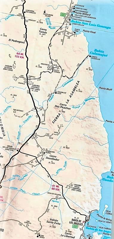
About 8 miles north of the L.A. Bay highway junction with Highway One, the old L.A. Bay road crosses the highway, going to the southeast. At this same
point, a newer road was graded and reached Highway One going off to the northeast (GPS NAD27 N29º09.59' W114º08.63').
It was a smooth, easy climb up the long slope. The Baja 1000 parallel road is crossed 1.3 mi. from Hwy.1. A corral and new well is passed 3.2 mi.
beyond that crossing. The road gets a little bumpy as it winds through some boulders at the foot of the mountain. Then, around another bend, my heart
sunk... a locked gate! I was 7.1 miles from Highway One and 2/3 the way to the ranch and Sal Si Puedes. BUMMER!!! I climbed the boulder-covered hill
to scan the area. I could see the mountain next to Tinaja de Yubay, about 6 miles to the south-east and the road (I wanted to drive) climb further up
the mountain. The gate is at 29º12.75'/ 114º03.19', elev. 2,600' (that's a 1,100' climb from Highway One). I drove back a couple miles and stopped to
hike around a bit and found lots of quartz.
I got back to Highway One and turned north. At El Crucero (29º14.30'/ 114º09.28'), the race pit vehicles were gone, but a rancher's truck was there...
driving through a new gate. If this is ever locked, the old road from San Felipe, Gonzaga, and Calamajue Canyon would be closed at its southern end! I
spoke with the man, and he said his new ranch house was nearby and his ranch was also called El Crucero. I showed him a photo of the original El
Crucero taken in the late 1960's. I expressed my concern for all the new fences along Highway One and gates over roads. He said his gate would not be
locked. But, if it was, one could get to Calamajue by going 6.5 miles north to the water truck access road built for Highway One's construction at
29º17.52'/ 114º14.30'. I mentioned my attempt at reaching Sal Si Puedes was cut short by such a gate. The ranch at the end of that road is called San
Luis, he said. Baja was once known as the land with 'hardly any fences'... That too, is changing.
|
|
|
Barry A.
Select Nomad
Posts: 10007
Registered: 11-30-2003
Location: Redding, Northern CA
Member Is Offline
Mood: optimistic
|
|
Interesting, David. This area is slowly being opened up, it would seem. There are now so many reported roads that I could probably spend a couple
of weeks in that area exploring and poking around. That area has always fascinated me since reading the Earle Stanley Gardner's book on the area.
Thanks, David--------excellent stuff!!!!
Barry
|
|
|
David K
Honored Nomad
Posts: 65581
Registered: 8-30-2002
Location: San Diego County
Member Is Offline
Mood: Have Baja Fever
|
|
| Quote: | Originally posted by TW
The old guy that lived in LA Bay that was always looking for gold mentions in one of his last chapters in his book about the ranch and about the son
of the owner. I can't find my copy of the book or I would be more specific. |

|
|
|
TMW
Select Nomad
Posts: 10659
Registered: 9-1-2003
Location: Bakersfield, CA
Member Is Offline
|
|
That's it. Chapter 30 is where Hill talks about the ranch and the son etc.
|
|
|
David K
Honored Nomad
Posts: 65581
Registered: 8-30-2002
Location: San Diego County
Member Is Offline
Mood: Have Baja Fever
|
|
| Quote: | Originally posted by TW
That's it. Chapter 30 is where Hill talks about the ranch and the son etc. |
Just re-read it... maybe San Luis? Herman is purposely vague on his details... for good reason! He did say he was north and west of Yubay... so that
fits.
|
|
|
larryC
Super Nomad
Posts: 1499
Registered: 8-11-2008
Location: BoLA
Member Is Offline
|
|
| Quote: | Originally posted by David K
Barry, here is my trip report from Nov. 2002 on that ranch road:
Baja Weekend Part 3:
Sal Si Puedes, NOT!
While at Beach Bob's, we discussed exploring Baja. He told me of a neighbor and friend who wanted to go into Sal Si Puedes canyon, north of L.A. Bay.
This was the palm-lined canyon made famous in Erle Stanley Gardner's 1961 'Hovering Over Baja'. Sal Si Puedes translates to 'Get Out If You Can'! To
Erle and others it meant Get 'IN', if you can! Earlier this year I emailed with a Baja explorer who did get to Sal Si Puedes from Highway One. I told
Beach Bob to tell his friend. I even had the GPS data for the ranch on the mountain above the canyon and the canyon's headwater. I decided to visit
the ranch and see the top of Sal Si Puedes.
About 8 miles north of the L.A. Bay highway junction with Highway One, the old L.A. Bay road crosses the highway, going to the southeast. At this same
point, a newer road was graded and reached Highway One going off to the northeast (GPS NAD27 N29º09.59' W114º08.63').
It was a smooth, easy climb up the long slope. The Baja 1000 parallel road is crossed 1.3 mi. from Hwy.1. A corral and new well is passed 3.2 mi.
beyond that crossing. The road gets a little bumpy as it winds through some boulders at the foot of the mountain. Then, around another bend, my heart
sunk... a locked gate! I was 7.1 miles from Highway One and 2/3 the way to the ranch and Sal Si Puedes. BUMMER!!! I climbed the boulder-covered hill
to scan the area. I could see the mountain next to Tinaja de Yubay, about 6 miles to the south-east and the road (I wanted to drive) climb further up
the mountain. The gate is at 29º12.75'/ 114º03.19', elev. 2,600' (that's a 1,100' climb from Highway One). I drove back a couple miles and stopped to
hike around a bit and found lots of quartz.
I got back to Highway One and turned north. At El Crucero (29º14.30'/ 114º09.28'), the race pit vehicles were gone, but a rancher's truck was there...
driving through a new gate. If this is ever locked, the old road from San Felipe, Gonzaga, and Calamajue Canyon would be closed at its southern end! I
spoke with the man, and he said his new ranch house was nearby and his ranch was also called El Crucero. I showed him a photo of the original El
Crucero taken in the late 1960's. I expressed my concern for all the new fences along Highway One and gates over roads. He said his gate would not be
locked. But, if it was, one could get to Calamajue by going 6.5 miles north to the water truck access road built for Highway One's construction at
29º17.52'/ 114º14.30'. I mentioned my attempt at reaching Sal Si Puedes was cut short by such a gate. The ranch at the end of that road is called San
Luis, he said. Baja was once known as the land with 'hardly any fences'... That too, is changing. |
That's funny, I am the neighbor/freind of beach Bobs that was interested in salsipuedes canyon. I did make the trip up there and spent 4 nights in the
canyon. saw lots of big horn sheep, running water, and no sign what so ever that anyone had ever been there. Of course people have been in there but
not too often. I'll try to find my fotos of the trip and post them.
Larry
|
|
|
Barry A.
Select Nomad
Posts: 10007
Registered: 11-30-2003
Location: Redding, Northern CA
Member Is Offline
Mood: optimistic
|
|
Larry----------Did you go to the canyon Sal Si Puedes the same way David K tried to go??? (via the Rancho road) And if so, were the gates not a
problem for you??
Thanks, Barry
Ah Ha-----I see LarryC has started his own thread answering my questions, so disregard my above questions.
Thanks Larry.
[Edited on 3-18-2012 by Barry A.]
|
|
|
larryC
Super Nomad
Posts: 1499
Registered: 8-11-2008
Location: BoLA
Member Is Offline
|
|
Barry
I have been up to those ranchos 3 or 4 times. The gate has never been locked but usually closed. I go through and then close the gate behind me. Realy
beautiful place up there, huge granite boulders similar to Catavina area and lots of Blue palms. Also a natural spring and lots of trees. I have heard
that there are indian petroglyphs but I have not found them. Maybe next trip
|
|
|
willardguy
Elite Nomad
Posts: 6451
Registered: 9-19-2009
Member Is Offline
|
|
are you the same larry that was in the discoverbaja article about hiking up to the san juan mine?
|
|
|
CortezBlue
Super Nomad
Posts: 2213
Registered: 11-14-2006
Location: Fenix/San Phelipe
Member Is Offline
|
|
Perhaps they had a fashion show and it was the runway they used to run the models up and down?
|
|
|
David K
Honored Nomad
Posts: 65581
Registered: 8-30-2002
Location: San Diego County
Member Is Offline
Mood: Have Baja Fever
|
|
| Quote: | Originally posted by willardguy
are you the same larry that was in the discoverbaja article about hiking up to the san juan mine? |
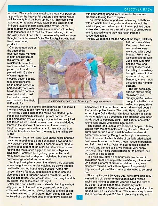
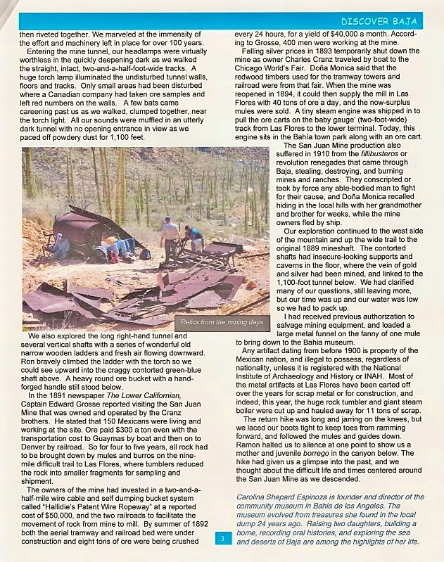
That was a great article, April, 2009 by Carolina Espinoza...
http://www.discoverbaja.com/pdf/apr09.pdf
I have been wanting to get up there for years... The tramline remains, terminal, Las Flores railroad line I have seen... but not the gold/silver mine
itself.
[Edited on 3-19-2012 by David K]
|
|
|
David K
Honored Nomad
Posts: 65581
Registered: 8-30-2002
Location: San Diego County
Member Is Offline
Mood: Have Baja Fever
|
|
| Quote: | Originally posted by willardguy
same larry? |
Larry will have to tell you, but here is that 3 page article... a big reason I join Discover Baja Travel Club is their great quarterly newsletters,...
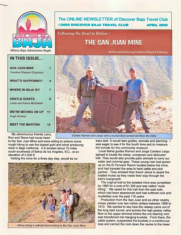
The ghost town of Las Flores, south of Bahia de los Angeles (only the jailhouse/ gold vault remains standing, built by Dick Daggett) is where the ore
was processed and poured into ingots. The railroad engine on display in town, was originally at Las Flores and brought the ore to town from the base
of the mountain that San Juan sits on top of. You can see the mine tunnel opening on Google Earth.
|
|
|
larryC
Super Nomad
Posts: 1499
Registered: 8-11-2008
Location: BoLA
Member Is Offline
|
|
Willard,
Yes that was me, what a great trip, I am anxious to go again. Maybe we could drum up some interest here to organize another trip? I found a guide that
says he can provide mules and guides for a trip.
Larry
|
|
|
willardguy
Elite Nomad
Posts: 6451
Registered: 9-19-2009
Member Is Offline
|
|
could you or david pin the san juan mine area on the google map? is it close to the tinaja yubay area? and what the heck is a tinaja?
|
|
|
larryC
Super Nomad
Posts: 1499
Registered: 8-11-2008
Location: BoLA
Member Is Offline
|
|
The san Juan mine is actually closer to San Borja, but quite a hike from there. You can also access the mine the way we went which was up through the
Las Flores area, even a worse hike. David will have to show you the GE pictures, the GE coordinates are N 28 42 38.55 by W 113 34 28.50
Hope this helps.
Larry
A Tinaja is a water hole.
|
|
|
| Pages:
1
2
3
4
5 |