| Pages:
1
2
3 |
willardguy
Elite Nomad
     
Posts: 6451
Registered: 9-19-2009
Member Is Offline
|
|
david, are all your maps available on a site?
|
|
|
David K
Honored Nomad
        
Posts: 65361
Registered: 8-30-2002
Location: San Diego County
Member Is Offline
Mood: Have Baja Fever
|
|
Yup, right here on Baja Nomad! See the Historic Intersts forum... You can
also go directly to my Photobucket Maps Album, I believe Baja is good for your mind and health... check your u2u! See the Historic Intersts forum... You can
also go directly to my Photobucket Maps Album, I believe Baja is good for your mind and health... check your u2u!
|
|
|
bufeo
Senior Nomad
  
Posts: 793
Registered: 11-16-2003
Location: Santa Fe New Mexico
Member Is Offline
|
|
I have all those maps...and more (including Spanish pilots from the 18th century and none places the name of Ensenada de San Francisquito on that
bay), but while they're nice to look at they don't answer my question, and, quite frankly, an answer really doesn't matter except you're such a pedant
for "historical" accuracy.
Here I quote from a letter to me from Pete Gerhard dated July 1971, "Quite right, Allen, we sometimes used (or misused [and he inserted a question
mark here]) other names for places in an effort to thwart copyright enfringement [sic]" This was in reference to a question I raised with PG regarding
names for a rancho, spring, and nearby arroyo on one of their maps. His explanation was reasonable and since the specific names I questioned would not
lead some unsuspecting expeditioner astray they were harmless. This was a common practice, as you know, of cartographers.
My point is, and I'm not trying to impugn your sources, that often these names we find in Baja California are, in a word, arbitrary. After all,
Consag, himself, spelled his name Konscak, Konsag and Konschak on separate documents, so it should not be a surprise that the little bight
between Punta Final and Punta Willard might possess another name, perhaps even a pseudonym. What's "correct" is open to discussion.
The more important issue is that folks are interested in the past, and, specifically for us here on Baja Nomad, the past of Baja California.
One of my most cherished possessions is a map that I acquired in a little antique shop in northern Florida about fifty years ago. I had just been
introduced to the land that lay south of California, and my wife and I were on a trip to the east. I found in this little shop an original Isaac
Tirion (1765) map of Arizona and Baja California. Unfortunately, it offers us no hint about the little bay we're discussing.
It's an engaging little map and on it are myriad spelling differences from the modern, and even other historical maps of the period. The different
spellings (e.g. "St. Quintins Baay") are wonderful view into the past. The mixture of Dutch, Spanish, German, and the gross misplacement of islands
and land fixtures are simply a look at one cartographer's attempt at an expeditioner's aid.
They're all good.
Oh, and by the way while we're at it ("Just for fun", of course.  ) )
| Quote: | | Originally posted by David K...The big bay most call Gonzaga is actually 'Ensenada de San Francisquilto' ... |
It's Ensenada de San Francisquito without the 'l'. Just thought you'd like to correct that.
Allen R.
[Edited on 4-4-2012 by bufeo]
|
|
|
David K
Honored Nomad
        
Posts: 65361
Registered: 8-30-2002
Location: San Diego County
Member Is Offline
Mood: Have Baja Fever
|
|
Oh yes, thank you... that was indeed a typo...
I love the research and no matter what the outcome, none of us were there when the names were applied... well, I do take an exception for at least two
in Baja (Shell Island and The Widowmaker) 
Cool you exchanged with Peter Gerhard... I did meet Howard Gulick back in 1966 or so and we (with my dad) discussed our route to La Paz and Cabo from
Tijuana. He autographed my Lower California Guidebook, then.
I am working on a new mission book with another author, and I have cited Gerhard and Gulick as one of my references...
Have you ever researched the meaning of Punta Bufeo?
|
|
|
bufeo
Senior Nomad
  
Posts: 793
Registered: 11-16-2003
Location: Santa Fe New Mexico
Member Is Offline
|
|
| Quote: | | Originally posted by David K...Have you ever researched the meaning of Punta Bufeo? |
Yes.
Allen R
|
|
|
David K
Honored Nomad
        
Posts: 65361
Registered: 8-30-2002
Location: San Diego County
Member Is Offline
Mood: Have Baja Fever
|
|
| Quote: | Originally posted by bufeo
| Quote: | | Originally posted by David K...Have you ever researched the meaning of Punta Bufeo? |
Yes.
Allen R |
Does it take a Pacifico to learn of your findings? 
|
|
|
bufeo
Senior Nomad
  
Posts: 793
Registered: 11-16-2003
Location: Santa Fe New Mexico
Member Is Offline
|
|
| Quote: | Originally posted by David K...Does it take a Pacifico to learn of your findings?  |
"A" Pacifico??? My time is worth much, much more than that.
Anyway, I didn't find what one might say is "unimpeachable" information.
One source (our landowner, Francisca Fernandez-Romero, daughter of Papa Fernandez) told me that the playa and point were named thusly owing to the
frequent sightings of orcas and finback whales in the channel.
That makes some sense. Bufar in Spanish means "snort" or "blow", and in some cases "fume".
However, with Isla Encantada being a volcanic cone (caldera still easy to see) that has had activity well within the times of Spanish explorers
volcanologists I spoke with said they thought the name might have come at a time when "fuming" from the island was evident.
Without some strong evidence, i.e. a journal or diary entry from an expeditioner, I'm reluctant to make a judgement about it.
The folks at Campo Punta Bufeo use an orca on their t-shirts, so I think they're convinced.
Geographic naming is a game of "first in time, first in line" I think. Of course, then there's the "Renaming" to commemorate some person or event.
This brings to mind an anecdote, so I digress.
June 1986 my wife, daughter, and I were on a river trip through Desolation Canyon, that part of the Green River in Utah. We were with the Grand Canyon
Dories, and it was Martin Litton's last trip on that river. He was selling his commercial permit to another group in order to focus on other rivers.
It was a small group of guests along, twelve or so I think, and most of us were there for the geology, the history, and the experience of accompanying
Litton on this last float through the canyon.
I was in a dory on one day with a chatty guest who could not stop asking names of places along the river. The guest did not appear to have any
interest in knowing just where we were on the river, or on the globe, for that matter, just wanted to know "What's that called"?
As were rounding one bluff on a particularly quiet stretch of the river the guest asked once more about the name of the bluff.
The patient guide looked at it for a few seconds then asked, "Well, what does it remind you of"?
The guest replied, "Sort of looks like a duck's head".
"You got it," the guide with an absolutely straight face answered. "The Spanish named it Cabezo de Patito"
"Ahhh, cool," the guest said.
I looked long and hard at that bluff, and for the life of me I couldn't see a duckling, so that evening in camp I eased over near the guide with my
gin and tonic and quietly asked, "You made that up about the name of that point this afternoon, didn't you"?
The guide looked at me with a most engaging twinkle in her eye. "Whatever works."
So there you have it. There's a point now along the Green River between Rock Horse Rapid and Stampede Flat that is called "Duckling's Head" or maybe
it's "Ducky's Head" or maybe...?
Allen R
[Edited on 4-4-2012 by bufeo]
|
|
|
David K
Honored Nomad
        
Posts: 65361
Registered: 8-30-2002
Location: San Diego County
Member Is Offline
Mood: Have Baja Fever
|
|
Wonderful story Allen!
I like your answer for Punta Bufeo... much like La Bufadora over at Punta Banda by Ensenada.
|
|
|
David K
Honored Nomad
        
Posts: 65361
Registered: 8-30-2002
Location: San Diego County
Member Is Offline
Mood: Have Baja Fever
|
|
Of interest, the maps in the Lower California Guidebook were drawn by Howard Gulick, an engineer with the City of Glendale, CA. Following WWII, he
traveled extensively on the peninsula making road logs and maps. Andy Anderson, a friend of Howard's (and my father), often traveled with Gulick. Andy
told us that Howard was so precise with his map making, that every bend in the road, he would note the mileage, take out his compass on a tripod, walk
20 feet from his Willys Jeep and note the new heading.
Since Peter Gulick was a published historian and had much knowledge about the southern half of the peninsula, it seemed like a good partnership for
the book!
I have only seen a couple of 'errors' on Howard's maps, and they are on roads that he or Gerhard never traveled (and they say so in the book). Mainly
in the Magdalena Plain to Magdalena Bay region.
The visita of San Pablo is also placed slighty too far north, and again it was not visited by the authors.
Unpublished were Howard Gulick's notes and maps of the El Camino Real from Loreto to El Rosario (1954)... I have 'published' the maps on my web site
for all to enjoy... Harry Crosby was greatly aided by Gulick's work for Harry's 'King's Highway in Baja California' adventure book.
The 1954 E.C.R. maps by Howard Gulick: http://www.vivabaja.com/ECR/page12.html
[Edited on 4-4-2012 by David K]
|
|
|
David K
Honored Nomad
        
Posts: 65361
Registered: 8-30-2002
Location: San Diego County
Member Is Offline
Mood: Have Baja Fever
|
|
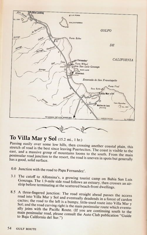
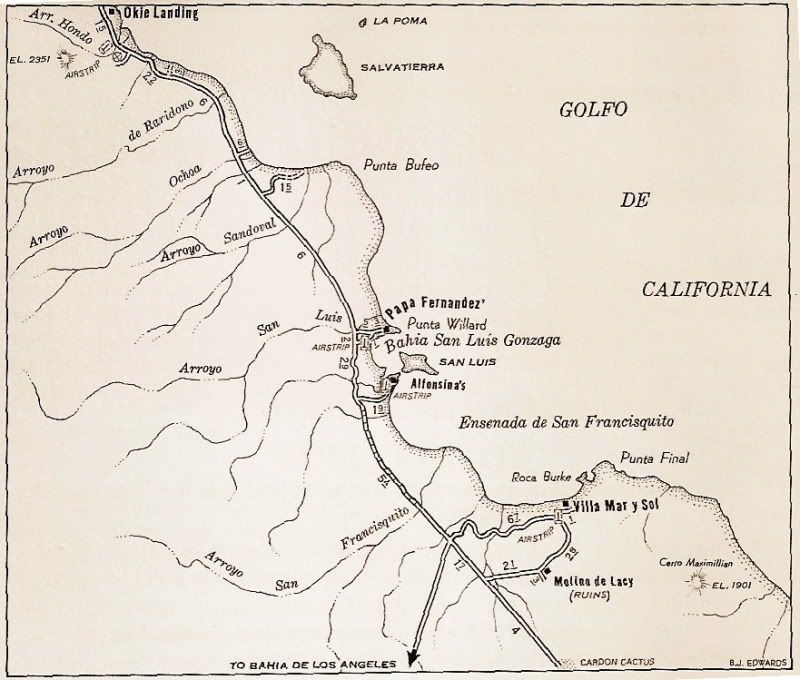
1970 Auto Club Guide to Baja CA del norte
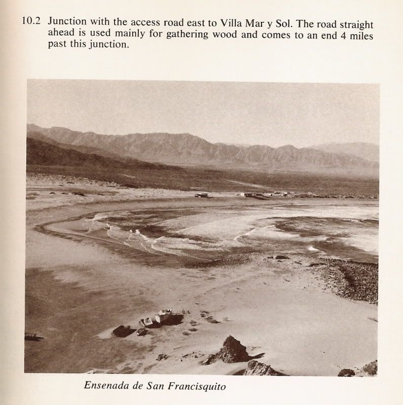
Some more maps and photo that show Ensenada de San Francisquito (the larger half of 'Gonzaga Bay') and the Villa Mar Y Sol illegal resort... (now
called Punta Final)


Arroyo San Francisquito is actually the branch that turns south (called Arroyo Las Arrastras in the topo maps)... most of what is labled above is
actually Arroyo Santa Maria.

Photo taken from Snoopy at Punta Final.
[Edited on 4-24-2012 by David K]
|
|
|
Oso
Ultra Nomad
    
Posts: 2637
Registered: 8-29-2003
Location: on da border
Member Is Offline
Mood: wait and see
|
|
Been there, done that. Had a couple pix of my old and new trucks across from birdsh*t island but lost the digitals when my last PC crashed. Couple
flats, front driveshaft popped loose, but the "worst" was losing a camper shell between Puertecitos and Gonzaga. Lucky it was a cheap one. Some
passing Chicano tourists helped me get it out of the road. Everyone was joking about how it would become a taco stand the next day. Met Mike a
couple times for the Baja Mil.
All my childhood I wanted to be older. Now I\'m older and this chitn sucks.
|
|
|
David K
Honored Nomad
        
Posts: 65361
Registered: 8-30-2002
Location: San Diego County
Member Is Offline
Mood: Have Baja Fever
|
|
Ah, the memories! On the old road (1979) I lost my exhaust on the rocks; On the newer graded road had a couple of flats (too much air and driving too
fast).
|
|
|
Ken Cooke
Elite Nomad
     
Posts: 8970
Registered: 2-9-2004
Location: Riverside, CA
Member Is Offline
Mood: Pole Line Road postponed due to injury
|
|
| Quote: | Originally posted by David K
Ah, the memories! On the old road (1979) I lost my exhaust on the rocks; On the newer graded road had a couple of flats (too much air and driving too
fast). |
David K driving too fast??? I don't believe it.
|
|
|
David K
Honored Nomad
        
Posts: 65361
Registered: 8-30-2002
Location: San Diego County
Member Is Offline
Mood: Have Baja Fever
|
|
| Quote: | Originally posted by Ken Cooke
| Quote: | Originally posted by David K
Ah, the memories! On the old road (1979) I lost my exhaust on the rocks; On the newer graded road had a couple of flats (too much air and driving too
fast). |
David K driving too fast??? I don't believe it. |
Umm, no... the road was not what you would think is a road or even think is a bad road... it was more of a goat trail. Having a 4WD Subaru with 13"
tires didn't give me a ton of ground clearance either.... 
|
|
|
Ken Cooke
Elite Nomad
     
Posts: 8970
Registered: 2-9-2004
Location: Riverside, CA
Member Is Offline
Mood: Pole Line Road postponed due to injury
|
|
I remember watching you let the hammer down on the accelerator on Hwy 5 after a weekend at Shell Island with the kids crammed into your gold Tacoma.
You drove that thing like Ivan Stewart!
|
|
|
David K
Honored Nomad
        
Posts: 65361
Registered: 8-30-2002
Location: San Diego County
Member Is Offline
Mood: Have Baja Fever
|
|
Okay, sure... if you say so Ken!  
|
|
|
bigboy
Nomad
 
Posts: 239
Registered: 12-28-2003
Member Is Offline
|
|
I drove that road many times in the early 70's! I drove a 1971 Ford F250 4X4 with a granny low and a two speed transfer case. I would crawl up those
grades at walking speed with that setup.
I had a cab high Gem Top shell with a 13' Gregor straped to the top of the camper. One tuff rig that took me to Cabo three times before the highway
was punched through the mid section of Baja!
|
|
|
thebajarunner
Ultra Nomad
    
Posts: 3754
Registered: 9-8-2003
Location: Arizona....."Free at last from crumbling Cali
Member Is Offline
Mood: muy amable
|
|
No photos, but lots of memories
We raced that road, and it was brutal!
Did it north bound in the 1972 500 and south bound in the fall 1000.
My vivid memory is a buggy broke down on one of the steep grades and all the other drivers congregated and pushed it over the side and down the cliff-
hey, ya gotta do what ya gotta do.
Pre-running north bound (my first ever) we used a stick shift Ford pickup and peeled all the tread off the rear tires as we spun, sputtered and
chattered up those grades! It was auto/trans from that moment on.
|
|
|
David K
Honored Nomad
        
Posts: 65361
Registered: 8-30-2002
Location: San Diego County
Member Is Offline
Mood: Have Baja Fever
|
|
Good thread from Ken Cooke!
|
|
|
Ken Cooke
Elite Nomad
     
Posts: 8970
Registered: 2-9-2004
Location: Riverside, CA
Member Is Offline
Mood: Pole Line Road postponed due to injury
|
|
Good times along THAT ROAD
Taking a bath before leaving for San Felipe

The Jeeps on the ready (all RUBICONs)

JEEPS JEEPS EVERYWHERE!

The "old road"


PUERTECITOS (gringo english: POERTOCITOUS)


Here comes a JEEP!

...AND ANOTHER!

|
|
|
| Pages:
1
2
3 |

