| Pages:
1
2
3
4 |
David K
Honored Nomad

Posts: 65562
Registered: 8-30-2002
Location: San Diego County
Member Is Offline
Mood: Have Baja Fever
|
|
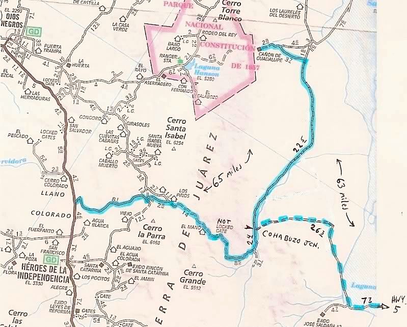
| Quote: | Originally posted by Mula
Map of the route, David K? |
I will need to work on that... The AAA map doesn't go past Cohabuzo Jcn much more than the 3.1 mile road shown....
The highligted road(s) include the Mano Canyon one (mentioned in the trip report) that I have been on... and the dashed one is the 'short cut' to Hwy.
5 (at the sand dunes).
Mexitron's route went south on that 3.1 mi. road... or a parallel one... but kept going south (not shown on AAA, but is shown on the Gulick maps that
Ken posted above).
|
|
|
Mexitron
Ultra Nomad
Posts: 3397
Registered: 9-21-2003
Location: Fort Worth, Texas
Member Is Offline
Mood: Happy!
|
|
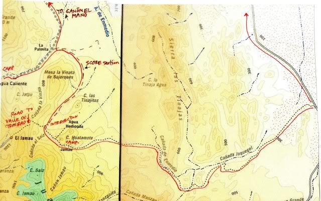
Here's a cut and paste from the Baja Almanac:
|
|
|
Barry A.
Select Nomad
Posts: 10007
Registered: 11-30-2003
Location: Redding, Northern CA
Member Is Offline
Mood: optimistic
|
|
Wow, great trip, Mexitron, and great trip-report & pics also. It is good to know that stock vehicles can still get thru on the Pole Line
road-------you guys did good!!!!
Barry
|
|
|
Mexitron
Ultra Nomad
Posts: 3397
Registered: 9-21-2003
Location: Fort Worth, Texas
Member Is Offline
Mood: Happy!
|
|
Barry---had no idea that was the road we were on---we were just exploring!
Sorry for the map not being oriented correctly, Photobucket won't rotate the image when copied to this site.
|
|
|
David K
Honored Nomad
Posts: 65562
Registered: 8-30-2002
Location: San Diego County
Member Is Offline
Mood: Have Baja Fever
|
|
Map looks fine Steve... Thanks...
The pole line came down the summit (Jamau) and right along your route and crossed Arroyo Grande and headed pretty straight for San Felipe.
|
|
|
Mexitron
Ultra Nomad
Posts: 3397
Registered: 9-21-2003
Location: Fort Worth, Texas
Member Is Offline
Mood: Happy!
|
|
| Quote: | Originally posted by David K
Map looks fine Steve... Thanks...
The pole line came down the summit (Jamau) and right along your route and crossed Arroyo Grande and headed pretty straight for San Felipe.
|
I gather the section going from Arroyo Grande to San Felipe is the more popular portion I often read about here? Jonathan Smith, one of our friends
on this trip, remembered riding the Pole Line Road on his bike but said it was a straighter route...
Meant to say we did see some CA fan palms in one of the Arroyo crossings---maybe the water is from the source of the "tinajas" that the Sierra is
named after. Be fun to explore again.
|
|
|
David K
Honored Nomad
Posts: 65562
Registered: 8-30-2002
Location: San Diego County
Member Is Offline
Mood: Have Baja Fever
|
|
Actually, the 'famous' Pole Line Road is the part you drove... with a few poles still up (I hope) and a cobble stone paved roadbed in places.
|
|
|
TMW
Select Nomad
Posts: 10659
Registered: 9-1-2003
Location: Bakersfield, CA
Member Is Offline
|
|
Mexitron how did you know when or where to turn up basketball hill? That turn is almost hidden unless you know the GPS coordinates. I've ridden that
route twice on a MC but never knew there was a right turn out of the wash until Ken Cooke had us on one of his trips. Was there tire tracks from other
vehicles you followed? I'm not questioning if you were on the PL Rd it's just the turn is something you just can't see unless there were other tire
tracks to follow or someone had a GPS and knew where to turn otherwise you go straight to a water falls and cow trail up the side of a hill, not
something a 4 wheel vehicle could make.
|
|
|
David K
Honored Nomad
Posts: 65562
Registered: 8-30-2002
Location: San Diego County
Member Is Offline
Mood: Have Baja Fever
|
|
Mexitron and Taco de Baja are old hands on the Baja trails... Have you seen the web page I made of the climbing of Matomi Mountain and hiking up
Matomi Canyon?
http://vivabaja.com/mexitron
[Edited on 4-9-2012 by David K]
|
|
|
Taco de Baja
Super Nomad
Posts: 1913
Registered: 4-14-2004
Location: Behind the Orange Curtain, CA
Member Is Offline
Mood: Dreamin' of Baja
|
|
| Quote: | Originally posted by David K
Actually, the 'famous' Pole Line Road is the part you drove... with a few poles still up (I hope) and a cobble stone paved roadbed in places.
|
We passed over several sections of the cobble stone paving. We were amazed someone went to the trouble of doing that on a dirt road in the midfle of
nowhere.
The pole line road explains it, thanks.
Truth generally lies in the coordination of antagonistic opinions
-Herbert Spencer
|
|
|
Mexitron
Ultra Nomad
Posts: 3397
Registered: 9-21-2003
Location: Fort Worth, Texas
Member Is Offline
Mood: Happy!
|
|
| Quote: | Originally posted by TW
Mexitron how did you know when or where to turn up basketball hill? That turn is almost hidden unless you know the GPS coordinates. I've ridden that
route twice on a MC but never knew there was a right turn out of the wash until Ken Cooke had us on one of his trips. Was there tire tracks from other
vehicles you followed? I'm not questioning if you were on the PL Rd it's just the turn is something you just can't see unless there were other tire
tracks to follow or someone had a GPS and knew where to turn otherwise you go straight to a water falls and cow trail up the side of a hill, not
something a 4 wheel vehicle could make. |
There were a few tracks (3?) we could follow so it wasn't too hard. There were some red spray paint marks along the whole route as well so I imagine
an off-road club went through there sometime this year.
|
|
|
Ken Cooke
Elite Nomad
Posts: 8971
Registered: 2-9-2004
Location: Riverside, CA
Member Is Offline
Mood: Pole Line Road postponed due to injury
|
|
| Quote: | Originally posted by Mexitron
There were a few tracks (3?) we could follow so it wasn't too hard. There were some red spray paint marks along the whole route as well so I imagine
an off-road club went through there sometime this year. |
We traveled through in November - 3 vehicles. If I see the spray paint, I will make sure it is erased. I am sure the spray painters don't know about
the hidden Suzuki Samurai.
Tinaja Mountains

Three Jeeps heading to Pole Line Road

From Summit, this landmark can be seen along with the split road where you turn right, heading up the steep hill.

Steep, paved dropoff

Rocky canyon leading to Basketball Hill

Blocked section of Basketball Hill

Traveling up Basketball Hill


Top of Basketball Hill leading immediately to Cowboy Canyon and Cañon Jaquegel

|
|
|
Neal Johns
Super Nomad
Posts: 1687
Registered: 10-31-2002
Location: Lytle Creek, CA
Member Is Offline
Mood: In love!
|
|
Wow! You guys were on the hard part of the Pole Line Road! And also got to the beautiful Agua Caliente Spring past La Palmita! Few Nomads have posted
going to that Agua Caliente. You did not have any fun at all, did you? 
Neal
My motto:
Never let a Dragon pass by without pulling its tail!
|
|
|
woody with a view
PITA Nomad
Posts: 15940
Registered: 11-8-2004
Location: Looking at the Coronado Islands
Member Is Offline
Mood: Everchangin'
|
|
more details on the agave spear, please!
|
|
|
Mexitron
Ultra Nomad
Posts: 3397
Registered: 9-21-2003
Location: Fort Worth, Texas
Member Is Offline
Mood: Happy!
|
|
Ken Cooke said: "We traveled through in November - 3 vehicles. If I see the spray paint, I will make sure it is erased. I am sure the spray painters
don't know about the hidden Suzuki Samurai."
Hey Ken---Yep, I recognize all those spots! Didn't mean the spray paint as a criticism---actually it was quite helpful in a couple spots! That's
amazing if those were your tracks we were following--no one else has been through for 5 months, wow. I don't think there's been enough rain to erase
tracks either---very dry out there.
|
|
|
Mexitron
Ultra Nomad
Posts: 3397
Registered: 9-21-2003
Location: Fort Worth, Texas
Member Is Offline
Mood: Happy!
|
|
| Quote: | Originally posted by woody with a view
more details on the agave spear, please! |
Actually we didn't mean to eat it in the first place but one of the kids was playing with a stick and knocked it over. Brooks suggested eating it---I
knew the Indians baked them in pits like asparagus but Brooks was eating a bit of it even without cooking...so we all gave it a try and decided to
cook it like chayote squash----cut it up and steam it, then add onions and olive oil for a quick fry, S&P, maybe a little butter and there you
have it---tastes about the same as chayote with a slight slime factor like okra.
|
|
|
Taco de Baja
Super Nomad
Posts: 1913
Registered: 4-14-2004
Location: Behind the Orange Curtain, CA
Member Is Offline
Mood: Dreamin' of Baja
|
|
| Quote: | Originally posted by woody with a view
more details on the agave spear, please! |
I was showing my 8 year old nephew how Los Indios used stone tools.
Two whacks with a stone chopper and the agave flower spear was severed .
Not wanting it to go to waste, I remembered that Los Indios in Baja and California used to roast and eat Agave and Yucca, so I took a tiny bite....and
found it to be surprisingly good, took more bites and shared it with the other campers. It's kind of like a cross between a chayote and an apple. With
its squash like qualities we decided to save it and cook it up that night with dinner. There is enough moisture and sweetness, that if you were dying
of thirst (dehydration) in the desert, these things might save your life.
My guess is that you have to "harvest them when they are young and tender, just like asparagus. If you wait too long they might be tough.
In several areas of Baja I have seen where the ranchers have cut 100s of the flower stocks; I always assumed they did it for livestock feed, but maybe
they cut a few for themselves..... 
Truth generally lies in the coordination of antagonistic opinions
-Herbert Spencer
|
|
|
woody with a view
PITA Nomad
Posts: 15940
Registered: 11-8-2004
Location: Looking at the Coronado Islands
Member Is Offline
Mood: Everchangin'
|
|
got it. gonna give it a try next time we're "out there"!
|
|
|
bacquito
Super Nomad
Posts: 1615
Registered: 3-6-2007
Member Is Offline
Mood: jubilado
|
|
| Quote: | Originally posted by Mexitron
| Quote: | Originally posted by Mula
Map of the route, David K? |
Brooks has all the GPS map data and he'll likely post another report about it, but the route can be seen on the Baja topos or atlas.
|
Great, look forward to it. Thanks, sounds like you had a great time
bacquito
|
|
|
Ken Cooke
Elite Nomad
Posts: 8971
Registered: 2-9-2004
Location: Riverside, CA
Member Is Offline
Mood: Pole Line Road postponed due to injury
|
|
| Quote: | Originally posted by Mexitron
Ken Cooke said: "We traveled through in November - 3 vehicles. If I see the spray paint, I will make sure it is erased. I am sure the spray painters
don't know about the hidden Suzuki Samurai."
Hey Ken---Yep, I recognize all those spots! Didn't mean the spray paint as a criticism---actually it was quite helpful in a couple spots! That's
amazing if those were your tracks we were following--no one else has been through for 5 months, wow. I don't think there's been enough rain to erase
tracks either---very dry out there. |
Those were most likely our tracks from 4 1/2 months ago. The spray paint was more than likely the white residue left from standing rain (Calcium)
deposits on the rocks that lined the Pole Line Road. We did a chemical evaluation of the rocks, and it was due to a form of Calcium deposits over
time (70 yrs.).
|
|
|
| Pages:
1
2
3
4 |


