| Pages:
1
2
3 |
mrfatboy
Nomad
 
Posts: 478
Registered: 4-17-2008
Member Is Offline
|
|
| Quote: | Originally posted by CortezBlue
MrFatBoy
Maybe we are twin brothers from different mothers??
Any who, from Gonzaga where is Pt Final |
As David K's map shows, Punta Final is 20-30 minutes south of Campo Beluga. If you are coming from the Rancho Grande store follow the signs to Campo
Beluga and just keep going. I think that is the best and most scenic road.
On the way back from Punta Final I took the main road out and was hoping to hit the main road from Rancho Grande store. It didn't happen and started
taking me more south on the way to CoCo's I guess. I had to double back 4 -5 miles. On the way back I saw a tiny little sign on a stick that said
"Alfonsia's". The road did not look very driven on. I took it anyway for the adventure. It did end up on the Main straight road from Rancho Grande.
Parts were very rough and steep. I would not take it again and just hug the nice mostly sandy road along the coast to Campo Sacraficio, Campo Beluga
and then on to Rancho Grande.
There are tons of roads criss crossing every which way down there.
|
|
|
David K
Honored Nomad
        
Posts: 65441
Registered: 8-30-2002
Location: San Diego County
Member Is Offline
Mood: Have Baja Fever
|
|
| Quote: | Originally posted by mrfatboy
| Quote: | Originally posted by CortezBlue
MrFatBoy
Maybe we are twin brothers from different mothers??
Any who, from Gonzaga where is Pt Final |
As David K's map shows, Punta Final is 20-30 minutes south of Campo Beluga. If you are coming from the Rancho Grande store follow the signs to Campo
Beluga and just keep going. I think that is the best and most scenic road.
On the way back from Punta Final I took the main road out and was hoping to hit the main road from Rancho Grande store. It didn't happen and started
taking me more south on the way to CoCo's I guess. I had to double back 4 -5 miles. On the way back I saw a tiny little sign on a stick that said
"Alfonsia's". The road did not look very driven on. I took it anyway for the adventure. It did end up on the Main straight road from Rancho Grande.
Parts were very rough and steep. I would not take it again and just hug the nice mostly sandy road along the coast to Campo Sacraficio, Campo Beluga
and then on to Rancho Grande.
There are tons of roads criss crossing every which way down there. |
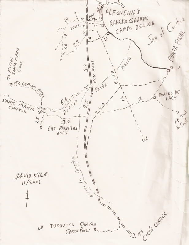
In 2002, while my son and I were visiting many of Gonzaga's points-of-interst (Turquoise Mine, Molino de Lacy, Mission warehouse ruin, El Camino Real,
Onyx springs), I sketched this map... shows the new dirt highway, the older road south, and some side roads:
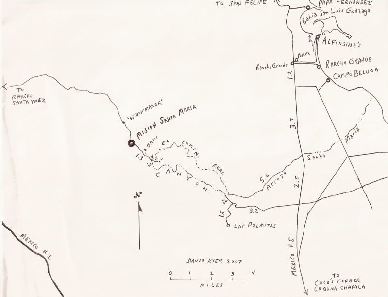
In 2007, I sketched this map which show the Camino Real and Santa Maria mission near Gonzaga Bay:
|
|
|
mrfatboy
Nomad
 
Posts: 478
Registered: 4-17-2008
Member Is Offline
|
|
Strange, when I came back from Punta Final and tried to hook up to Hwy 5 (which I finally did) I took a really rough road and that hooked up to what I
thought was the end of Hwy 5. I then just took it straight to Rancho Grande.
I must be remembering wrong. David K's maps are never wrong  (sincerely) (sincerely)
However, there are definitely more roads going all over the place as compared to the above maps.
Edit:
I just spoke to the wife. She verified that I didn't remember correctly  But I
am right about the new roads hugging closer to the coast going thru Campo Sacraficio (Campo Septico But I
am right about the new roads hugging closer to the coast going thru Campo Sacraficio (Campo Septico  ) )
[Edited on 6-19-2012 by mrfatboy]
|
|
|
David K
Honored Nomad
        
Posts: 65441
Registered: 8-30-2002
Location: San Diego County
Member Is Offline
Mood: Have Baja Fever
|
|
True, more roads than I show, plus Sacrificio is new since that map.
|
|
|
Edguero
Nomad
 
Posts: 112
Registered: 6-13-2006
Location: O\'side/Punta Final
Member Is Offline
|
|
That "rock crawling" Jeep was stuck there for 2 days, they winched it in for a photo shoot then broke something in the front end trying to get it out,
ran out of gas,burned up the winch, very entertaining, oldest rule in Baja "Don't drive below the high tide line" my wife got some good video.
|
|
|
mrfatboy
Nomad
 
Posts: 478
Registered: 4-17-2008
Member Is Offline
|
|
| Quote: | Originally posted by Edguero
That "rock crawling" Jeep was stuck there for 2 days, they winched it in for a photo shoot then broke something in the front end trying to get it out,
ran out of gas,burned up the winch, very entertaining, oldest rule in Baja "Don't drive below the high tide line" my wife got some good video.
|
Can you post the video on YouTube or something? I would like to see it. Lol. Was the jeep submerged at high tide?
|
|
|
David K
Honored Nomad
        
Posts: 65441
Registered: 8-30-2002
Location: San Diego County
Member Is Offline
Mood: Have Baja Fever
|
|
| Quote: | Originally posted by David K
True, more roads than I show, plus Sacrificio is new since that map. |
You know, Google Earth is great at seeing an area or using as an off road map!
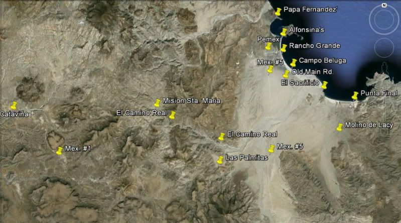
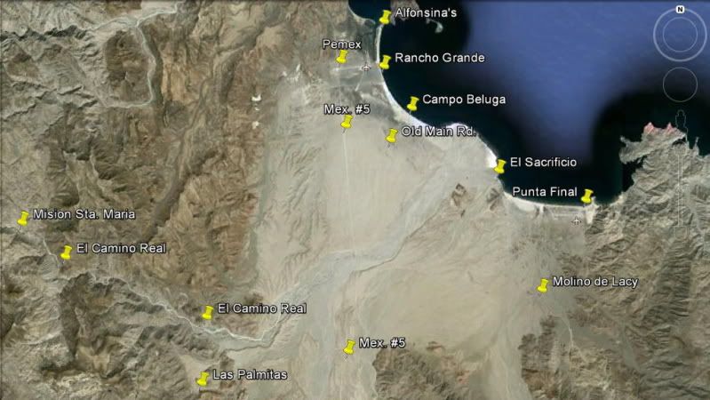
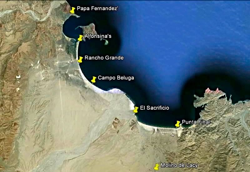
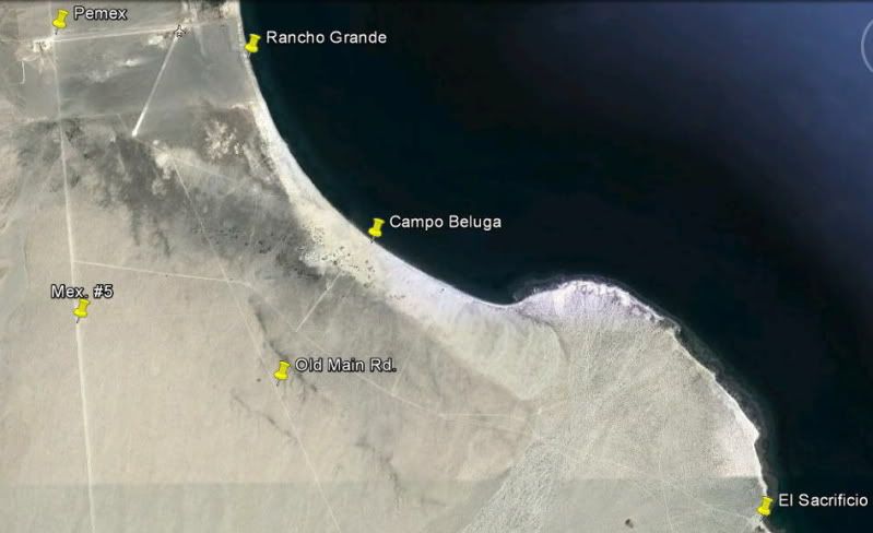
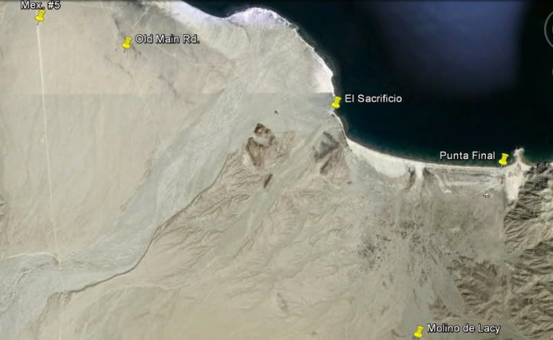
I didn't do a zoom in around Papa Fernandez', as there isn't much on the way of new desert roads there.
|
|
|
56MM#
Junior Nomad

Posts: 59
Registered: 2-3-2010
Member Is Offline
|
|
Was down in Gonzaga Bay last week on a day trip from San Felipe. Road from Puertecitos south is amazing (until it turns into a construction zone).
It's almost surreal going 50 miles on a vado-infested road from San Felipe to Puertecitos and then suddenly being on a two-lane road as good as the
best in the U.S. Outside of the construction zone, I only passed one other vehicle going the opposite way. Could maintain 70 mph on many stretches.
Some of the changes I noticed from when I was there 4-1/2 years ago included rock barriers on the beach designed to prevent people from driving motor
vehicles from Alfonsina's to the small bay just west of Punta Final. There was also a trailer at the entrance to the Punta Final housing area with a
sign that said $12 to enter. The guy guarding the place let me in without charge. I gave him a cold beverage on my way out.
Agreed that El Sacrificio had a creepy feeling...that and a lack of sand on their beach.
With the new road, I wonder how long it will be before Gonzaga Bay grows into another tourist destination like San Felipe. When the road is finished,
it will only be two more hours past San Felipe. For those of us who live in San Diego and have SENTRI cards, that's only seven hours each way to get
somewhere a world apart from southern CA.
|
|
|
David K
Honored Nomad
        
Posts: 65441
Registered: 8-30-2002
Location: San Diego County
Member Is Offline
Mood: Have Baja Fever
|
|
Water may be the big issue in too many homes or hotels at Gonzaga... The spring just west of Rancho Grande Market is full of minerals that make onyx
over the years. The spring that makes the oasis west of Punta Final (Las Palmitas), must have a limit. I would also thing the Arroyo Santa Maria
underground water has a limit?
|
|
|
redhilltown
Super Nomad
   
Posts: 1130
Registered: 1-24-2009
Location: Long Beach, CA
Member Is Offline
|
|
DK...are you using logic again?????  
They will build build build and THEN worry about the water supply!
|
|
|
David K
Honored Nomad
        
Posts: 65441
Registered: 8-30-2002
Location: San Diego County
Member Is Offline
Mood: Have Baja Fever
|
|
Seriously! Good call Red Hill Town!
|
|
|
mrfatboy
Nomad
 
Posts: 478
Registered: 4-17-2008
Member Is Offline
|
|
I edited the original post with the picture but here is the addition for the thread followers.
Here is a map how we crossed the border at Calexico East. For people that are travelling with you that DO NOT have a Sentri pass I found this drop
off/pick up method worked reasonable well.
Based on some comments in this forum and some people I talked to at Gonzaga Bay people seem to be more comfortable dropping off non Sentri people
before the bridge out of sight of an BP agent in a bad mood. Longer walk. YMMV.
The "before the bridge dropoff" is not a friendly drop off point for. Watch for cars, be prepared to jump and get to the sidewalk. Don't lolly gag
about and create a problem for others.

|
|
|
brewer
Nomad
 
Posts: 419
Registered: 1-4-2011
Location: BCS
Member Is Offline
Mood: Grateful
|
|
Just did Hwy 5 down and back up from Chapala. The road is in good shape. Air down to 25 psi and you should be good. Camped at Pta. Final going down
and back up. Saw whale sharks and 5 sea turtles. Alphonsina's is expanding. Getting ready for the new hwy coming in.
Trip report pictures coming soon.
|
|
|
mrfatboy
Nomad
 
Posts: 478
Registered: 4-17-2008
Member Is Offline
|
|
| Quote: | Originally posted by brewer
Just did Hwy 5 down and back up from Chapala. The road is in good shape. Air down to 25 psi and you should be good. Camped at Pta. Final going down
and back up. Saw whale sharks and 5 sea turtles. Alphonsina's is expanding. Getting ready for the new hwy coming in.
Trip report pictures coming soon. |
How is Alphonsia's expanding? I saw nothing going on 30 days ago.
|
|
|
David K
Honored Nomad
        
Posts: 65441
Registered: 8-30-2002
Location: San Diego County
Member Is Offline
Mood: Have Baja Fever
|
|
ALFONSINA'S
|
|
|
brewer
Nomad
 
Posts: 419
Registered: 1-4-2011
Location: BCS
Member Is Offline
Mood: Grateful
|
|
My friend bought into lot #1 about 8 months ago only to find out the lease will not be renewed. Number 2 is already demo'ed. The brothers plan to
expand the hotel and have the whole sand spit for Alfonsina's. It's too bad, he had a real nice set up there. But it makes sense if you are the
people running the hotel and restaurant.
|
|
|
mrfatboy
Nomad
 
Posts: 478
Registered: 4-17-2008
Member Is Offline
|
|
| Quote: | Originally posted by brewer
My friend bought into lot #1 about 8 months ago only to find out the lease will not be renewed. Number 2 is already demo'ed. The brothers plan to
expand the hotel and have the whole sand spit for Alfonsina's. It's too bad, he had a real nice set up there. But it makes sense if you are the
people running the hotel and restaurant. |
What happens to your friends lot when the lease expires? Does he loose his principe in the house?
|
|
|
David K
Honored Nomad
        
Posts: 65441
Registered: 8-30-2002
Location: San Diego County
Member Is Offline
Mood: Have Baja Fever
|
|
#2 was Doug Bowles place (with a hot tub)...
Douglas used to fly people and supplies to Alfonsina's... . He flew me to Oceanside from Alfonsina's in 1999... We had Thanksgiving dinner with him in
2002 at Alfonsina's.
Taking people back north a few years ago, he flew into a mountain, very sad
|
|
|
El Vergel
Nomad
 
Posts: 197
Registered: 8-27-2003
Location: San Felipe - Puertecitos Rd., Km. 35 and Santa Mon
Member Is Offline
|
|
Amigos,
Slightly north of Arr. Hondo (north of the beautifull-ness of the Gonzaga Bay) lies Okie Landing.
Whassup with this? History and visit info please, Nomads!
[Edited on 7-13-2012 by El Vergel]
|
|
|
David K
Honored Nomad
        
Posts: 65441
Registered: 8-30-2002
Location: San Diego County
Member Is Offline
Mood: Have Baja Fever
|
|
| Quote: | Originally posted by El Vergel
Amigos,
Slightly north of Arr. Hondo (north of the beautifull-ness of the Gonzaga Bay) lies Okie Landing.
Whassup with this? History and visit info please, Nomads!
[Edited on 7-13-2012 by El Vergel] |
Hi Vern,
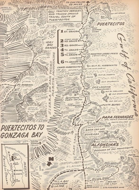
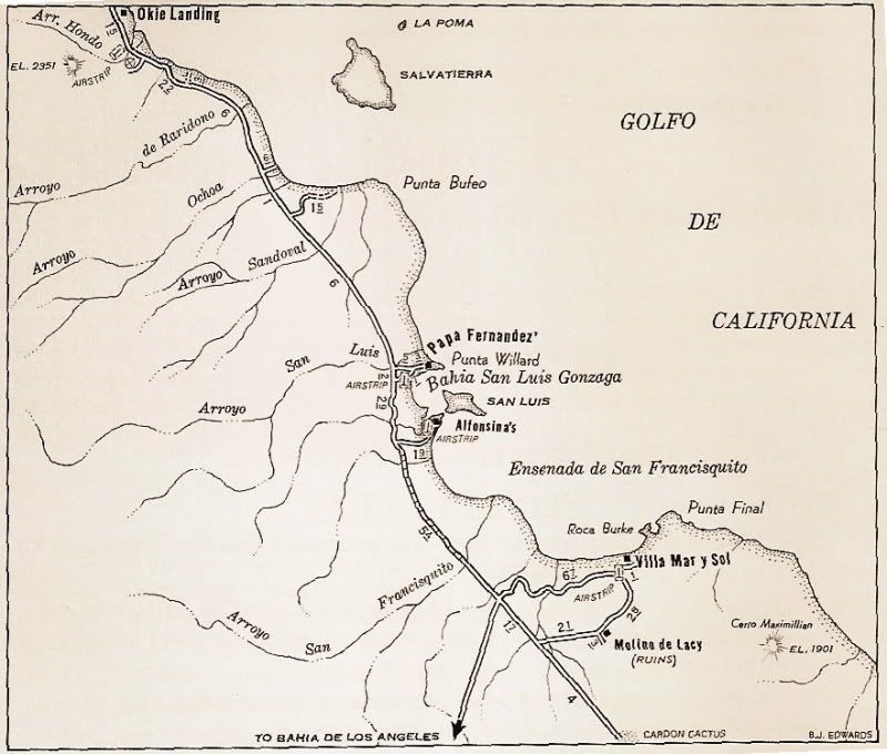
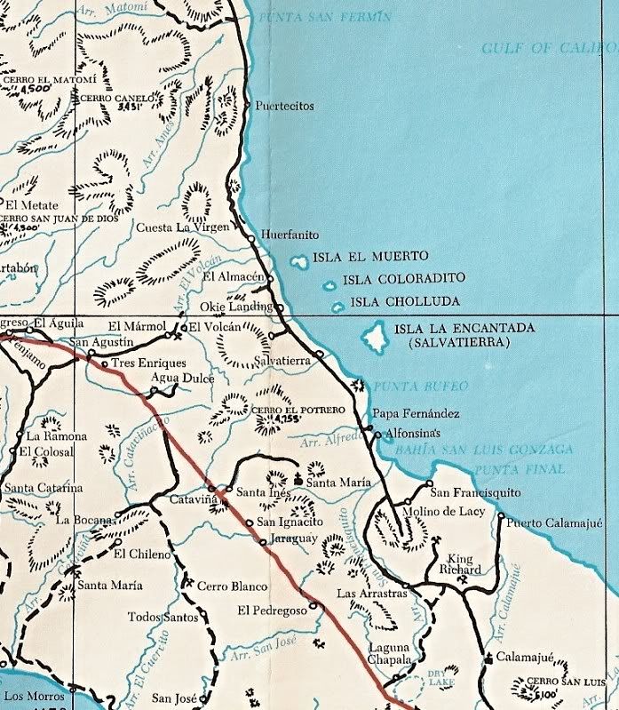
Okie Landing was a sport fishing camp in the 1960's. It used a cave for an ice room to store the fish. Today, just the concrete slabs remain where the
little rooms once where:

On maps:
1962:
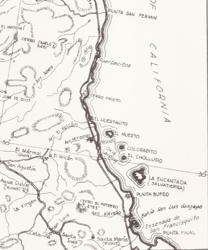
1970:
1975:
|
|
|
| Pages:
1
2
3 |

