| Pages:
1
2
3
4
..
37 |
bajajudy
Elite Nomad
     
Posts: 6886
Registered: 10-4-2004
Location: San Jose del Cabo,BCS
Member Is Offline
|
|
Not Odile yet
000
ABPZ20 KNHC 092332
TWOEP
TROPICAL WEATHER OUTLOOK
NWS NATIONAL HURRICANE CENTER MIAMI FL
500 PM PDT TUE SEP 9 2014
For the eastern North Pacific...east of 140 degrees west longitude:
Low pressure centered a couple hundred miles south-southwest of
Acapulco, Mexico, continues to show signs of organization.
Environmental conditions are conducive for additional development,
and a tropical depression could form later tonight or on Wednesday
while the low moves slowly northwestward just offshore the
southwestern coast of Mexico.
* Formation chance through 48 hours...high...70 percent.
* Formation chance through 5 days...high...90 percent.
A small area of low pressure located about 875 miles
south-southwest of the southern tip of the Baja California
peninsula has become a little better organized during the day.
However, significant development of this system is not anticipated
while it moves generally northward and then northeastward during the
next couple of days.
* Formation chance through 48 hours...low...20 percent.
* Formation chance through 5 days...low...20 percent.
$$
Forecaster Berg
|
|
|
BajaNomad
Super Administrator
        
Posts: 5018
Registered: 8-1-2002
Location: San Diego, CA
Member Is Offline
Mood: INTP-A
|
|
http://www.wunderground.com/hurricane/eastern-pacific/2014/I...
When I was young, I admired clever people. Now that I am old, I admire kind people.
â Rabbi Abraham Joshua Heschel
We know we must go back if we live, and we don`t know why.
â John Steinbeck, Log from the Sea of Cortez
https://www.regionalinternet.com
Affordable Domain Name Registration/Management & cPanel Web Hosting - since 1999 |
|
|
chuckie
Elite Nomad
     
Posts: 6082
Registered: 2-20-2012
Location: Kansas Prairies
Member Is Offline
Mood: Weary
|
|
Wrong storm
|
|
|
bajajudy
Elite Nomad
     
Posts: 6886
Registered: 10-4-2004
Location: San Jose del Cabo,BCS
Member Is Offline
|
|
| Quote: | Originally posted by chuckie
Wrong storm |
Nope...right one
|
|
|
chuckie
Elite Nomad
     
Posts: 6082
Registered: 2-20-2012
Location: Kansas Prairies
Member Is Offline
Mood: Weary
|
|
Eastern North Pacific?Nah....NHC shows easter pacific mess at 90% But....
|
|
|
chippy
Super Nomad
   
Posts: 1794
Registered: 2-2-2010
Member Is Offline
|
|
I guess if all goes as predicted I´ll get to see 9 meter surf here on sat/sun
[Edited on 9-10-2014 by chippy]
|
|
|
woody with a view
PITA Nomad
      
Posts: 15940
Registered: 11-8-2004
Location: Looking at the Coronado Islands
Member Is Offline
Mood: Everchangin'
|
|
120hr run shows it going up the gulf! this time tomorrow should be pretty accurate.....
LOOK OUT BELOW!!!
http://www.stormsurfing.com/cgi/display.cgi?a=npac_height
|
|
|
vandenberg
Elite Nomad
     
Posts: 5118
Registered: 6-21-2005
Location: Nopolo
Member Is Offline
Mood: mellow
|
|
Even the latest weatherunderground has this storm going up the Sea.
Sure hope they're wrong!!
|
|
|
micah202
Super Nomad
   
Posts: 1615
Registered: 1-19-2011
Location: vancouver,BC
Member Is Offline
|
|
.
.......YEEPS!!...now 3 of 5 projections are going that way   

...edit...this chart self-updates....the 2am update is showing a hopeful addition of an added possible track to the west
[Edited on 9-10-2014 by micah202]
|
|
|
ViajeraGal
Junior Nomad

Posts: 45
Registered: 9-2-2006
Location: Los Barriles
Member Is Offline
|
|
Sure hoping this girl/Odile behaves herself; I'm due to return to SJD afternoon of Fri/12th after two months in Asia.......and our casa is on the
beach north of Los Barriles.
|
|
|
micah202
Super Nomad
   
Posts: 1615
Registered: 1-19-2011
Location: vancouver,BC
Member Is Offline
|
|
.
....I'd have to say I'm rather more concerned with the prospects of the native population....they generally have a few less options than us gringo's
....altered plans vs altered -lives- 
|
|
|
landyacht318
Nomad
 
Posts: 247
Registered: 7-28-2007
Member Is Offline
|
|
The model predictions have been pretty unreliable this year even at 3 days out. Something to keep in mind, cause what they are saying now is not
looking good.
I'd prefer they all mimic Marie's track and intensity and flip the alphabet instead of Strafing all of Baja sur.
http://magicseaweed.com/MSW-Surf-Charts/19/?chartType=WMAG
|
|
|
bajabuddha
Banned
Posts: 4024
Registered: 4-12-2013
Location: Baja New Mexico
Member Is Offline
Mood: Always cranky unless medicated
|
|
This morning Odile is looking like becoming a 'named' storm for sure by this afternoon, and is not going to be a favorite Tourist of Baja. Another
system, 95E is out another 500 miles west, and the 'puter ensembles for that one are NERTZ! There are three graphs; one says west to sea, one says
north with hook-back to Baja and a third says 'right-turn, Clyde' and maybe hook up with future Odile. It's going to be a circus to watch over the
next few days. TD 15E (future Odile) says Tropical Storm by Friday, Cat-1 Saturday and South Cape landfall by Monday. All a crap-shoot, but i'd be
doing windows and buying water.... again...
Buena Suerte Sureños.... via con Dios. 
http://www.wunderground.com/hurricane/eastern-pacific/2014/T...
http://www.wunderground.com/hurricane/eastern-pacific/2014/I...
I don't have a BUCKET LIST, but I do have a F***- IT LIST a mile long!
86 - 45*
|
|
|
chuckie
Elite Nomad
     
Posts: 6082
Registered: 2-20-2012
Location: Kansas Prairies
Member Is Offline
Mood: Weary
|
|
And we'll be having our first snow in Colorado....
|
|
|
micah202
Super Nomad
   
Posts: 1615
Registered: 1-19-2011
Location: vancouver,BC
Member Is Offline
|
|
.
.....the odds-makers are only putting it at 5% to be a hurricane hitting Cabo,,40% for a TS---I'll go with that!  
...still a chance that house-fans,fridges,hopes and prayers can make a difference.... ..I perceive that TS's can be particularly modest
during the formulation period--perhaps it'd help if we all strip and spin clockwise!  
http://www.nhc.noaa.gov/refresh/graphics_ep5+shtml/084129.sh...
.
[Edited on 9-10-2014 by micah202]
|
|
|
bajajudy
Elite Nomad
     
Posts: 6886
Registered: 10-4-2004
Location: San Jose del Cabo,BCS
Member Is Offline
|
|
From Baja Insider
Wednesday, September 10, 2014 6:22 AM MDT We just finished with Hurricane Norbert battering the Pacific coast of the Baja peninsula, now we need to be
on alert for the threat of another this coming weekend. Tropical Depression 15E has formed off the southern coast of Mexico and is forecast to head
straight for us here in Baja California Sur late in the weekend. The is still some question as to the destination of this storm as in the initial
forecast it is only moving at 1kt and it has a great deal of land interaction to endure before making the jump across the open water from the mainland
to the Baja peninsula before we can tell for certain if and where landfall might occur and at what intensity the system will bring, five days in the
future. TD 15E is forecast to become Tropical Storm Odile as early as the 9AM forecast release. Folks with interests in the southern state of Baja
California Sur should follow the development of TD15E closely through the week. Much of the peninsula has enjoyed some cooler temps over the last few
days, caused by the passage of Hurricane Norbert. It is common for the weather to cool after the passage of a storm, but don't be fooled, we still
have another month of summer heat yet to endure.
In Baja California, Ensenada along the Pacific coast is looking for partly cloudy skies today and temps in the mid 70's, clearing tomorrow and temps
will rise through the weekend in to the mid 80's for some very summer like weather along the coast. Inland, Mexicali will be relatively cool today
with temps right around 100°F, but warming into the weekend close to 108°on Thursday. Along the Sea of Cortez, San Felipe will enjoy mostly sunny
skies and temps in the low 90's, but summer will return by the weekend and we can look for temps back around the century mark before the end of the
week.
In Baja California Sur, Guerrero Negro and the Pacific coast is still drying out and catching up with repairs following Norbert, but today will be
under partly cloudy skies and temps in the upper 80's to low 90's, cooling a bit more tomorrow, but then the temps will begin to rise again. Along the
eastern side of the peninsula, Loreto will have sun through the early weekend and temps climbing from the low 90's to the upper 90's by Saturday.
There is a forecast threat of thunderstorms on Sunday, likely associated with the arrival of what will then be Tropical Cyclone Odile. In La Paz it
will be sunny today with temps in the mid 90's through the weekend, increasing clouds by Saturday and the direct threat of Odile Sunday and moving
into the week ahead. Cabo San Lucas is expecting mostly sunny skies today and temps in the upper 80's, climbing into the low 90's on Saturday with
increasing humidity, Sunday's forecast appears a bit grim, with the forecasted landfall of Odile and temps falling to the mid 80's. It is still very
early in the long range forecast of TD15E but remain alert to the weather as the weekend approaches. There is a great deal of warm water south of the
peninsula and TD15E could gather a great deal of strength once it leave the Mexican mainland late Thursday. It would be wise for folks on the tip of
the peninsula to begin looking at preliminary storm preparations by tomorrow morning.
On our Tropical Watch we have of course, TD 15E which is the most direct threat to the peninsula on the horizon. The system is forecast to follow a
very similar course to Norbert, shifted a hundred miles or so to the east. This puts us right in the cross-hairs so stay tuned to the BajaInsider for
the latest tropical threat information. Enjoy your day...
|
|
|
micah202
Super Nomad
   
Posts: 1615
Registered: 1-19-2011
Location: vancouver,BC
Member Is Offline
|
|
| Quote: | Originally posted by micah202
.
.....the odds-makers are only putting it at 5% to be a hurricane hitting Cabo,,40% for a TS---I'll go with that!  
...still a chance that house-fans,fridges,hopes and prayers can make a difference.... ..I perceive that TS's can be particularly modest
during the formulation period--perhaps it'd help if we all strip and spin clockwise!  
http://www.nhc.noaa.gov/refresh/graphics_ep5+shtml/084129.sh... |
.
.....^^...........it's WORKING!!!!.....we need more people,,,spinning -faster-!!!   
,
|
|
|
bajabuddha
Banned
Posts: 4024
Registered: 4-12-2013
Location: Baja New Mexico
Member Is Offline
Mood: Always cranky unless medicated
|
|
ODILE'S FOR REAL; now a named Tropical Storm, will be CAT-2 and dead-on for the south cape by Sunday night/ Monday morning.
I don't have a BUCKET LIST, but I do have a F***- IT LIST a mile long!
86 - 45*
|
|
|
micah202
Super Nomad
   
Posts: 1615
Registered: 1-19-2011
Location: vancouver,BC
Member Is Offline
|
|
| Quote: | Originally posted by bajabuddha
ODILE'S FOR REAL; now a named Tropical Storm, will be CAT-2 and dead-on for the south cape by Sunday night/ Monday morning. |
too soon to say for sure,,,but projections have changed a LOT in 18hours....there's beginning to be hope of it just being a glancing
blow-40knots---SPIN HARDER FOLKS!!!   
...here's a revised ...PROJECTION.....

[Edited on 9-10-2014 by micah202]
|
|
|
vandenberg
Elite Nomad
     
Posts: 5118
Registered: 6-21-2005
Location: Nopolo
Member Is Offline
Mood: mellow
|
|
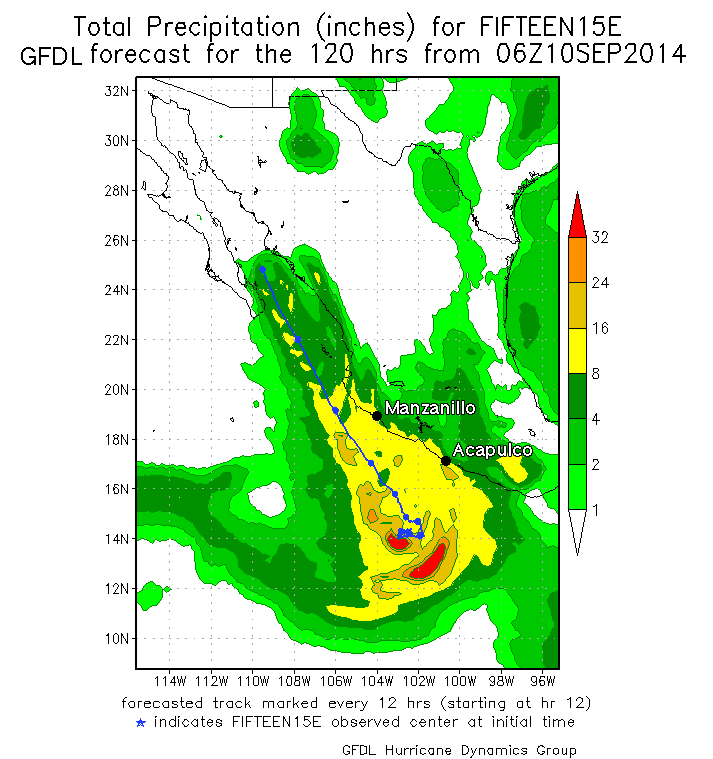
Predicted rainfall along the track of Odile from the 06Z (2 am EDT) September 10, 2014 run of the GFDL model. The model predicted that TD 15-E would
be a strong tropical storm or Category 1 hurricane as it brushed the coast of Mexico this week, bringing widespread rains of 8 - 16" along the coast
from Acapulco to Manzanillo.

|
|
|
| Pages:
1
2
3
4
..
37 |

