| Pages:
1
2
3 |
pacocacho
Newbie
Posts: 13
Registered: 6-2-2015
Member Is Offline
|
|
Quote: Originally posted by Sjsam  | | Nice story ,But the road 15 years ago Was paved from Insurgentes north to La Pursima. Around 1980 after Saragosa going north it was still dirt.
|
You are right... the talcum powder thing must have been north of La Purisima... even after San Juanico... I cant remember the exact location.
Will try to find some negatives from that trip and scan them.
By the way, I looked at the whale sculpture near the San Ignacio lagoon, and its fading out.
And Blanca looks like its heading directly to la Laguna de San Ignacio, I hope it doesnt blow it out completely.
Look in 26°49'58.8"N 113°08'26.2"W before its too late.
Cheers
|
|
|
Sjsam
Newbie
Posts: 17
Registered: 2-15-2013
Member Is Offline
|
|
There was some of that stuff (moon dust) between La Purisma and San juanico.also north of the turnoff for San Jose de Garcia there are a couple of
arroyos that were the same stuff but way worst then the others to the south. That's about 1980
|
|
|
Sjsam
Newbie
Posts: 17
Registered: 2-15-2013
Member Is Offline
|
|
Oh ya for all I know it might still be that way. There's better ways to go then that way
|
|
|
Marc
Ultra Nomad

Posts: 2802
Registered: 5-15-2010
Location: San Francisco & Palm Springs
Member Is Offline
Mood: Waiting
|
|
Can't find the whale on Google. Can you give coordinates?
|
|
|
pacocacho
Newbie
Posts: 13
Registered: 6-2-2015
Member Is Offline
|
|
try
26°49'58.8"N 113°08'26.2"W
|
|
|
pacocacho
Newbie
Posts: 13
Registered: 6-2-2015
Member Is Offline
|
|
Can you see it? its a mother whale with its ballenato...
.
|
|
|
David K
Honored Nomad
Posts: 65492
Registered: 8-30-2002
Location: San Diego County
Member Is Offline
Mood: Have Baja Fever
|
|
Good post with stories to bump up!
|
|
|
4x4abc
Ultra Nomad
Posts: 4455
Registered: 4-24-2009
Location: La Paz, BCS
Member Is Offline
Mood: happy - always
|
|
This view is backed by the writings of Homer Aschmann, a geographer who spent much time in the peninsula in the '40s-'50s and who later wrote an
excellent article about Baja's road history (it can be found in a book compiling some of his writings titled The Evolving Landscape: Homer Aschmann's
Geography by Martin J. Pasqualetti).
do you have that book, David?
Harald Pietschmann
|
|
|
David K
Honored Nomad
Posts: 65492
Registered: 8-30-2002
Location: San Diego County
Member Is Offline
Mood: Have Baja Fever
|
|
| Quote: Originally posted by 4x4abc | This view is backed by the writings of Homer Aschmann, a geographer who spent much time in the peninsula in the '40s-'50s and who later wrote an
excellent article about Baja's road history (it can be found in a book compiling some of his writings titled The Evolving Landscape: Homer Aschmann's
Geography by Martin J. Pasqualetti).
do you have that book, David? |
Indeed!

Thanks to you, I discovered it had not yet been added to my Viva Baja Library... it is now! https://vivabaja.com/baja-books/
|
|
|
4x4abc
Ultra Nomad
Posts: 4455
Registered: 4-24-2009
Location: La Paz, BCS
Member Is Offline
Mood: happy - always
|
|
can you thumb through it and see whether he covers Boleo road building?
Harald Pietschmann
|
|
|
David K
Honored Nomad
Posts: 65492
Registered: 8-30-2002
Location: San Diego County
Member Is Offline
Mood: Have Baja Fever
|
|
Sorry Harald, Homer's book only was about the Native population and how the missions affected them. Here is the contents pages, there is no index.
I am aware of his map showing the history of the Baja highway, but it was not in the 1959 book, as that finally happened in 1973. Source of map: https://math.ucr.edu/~ftm/bajapages/BajaRoadPages/RoadHistor...
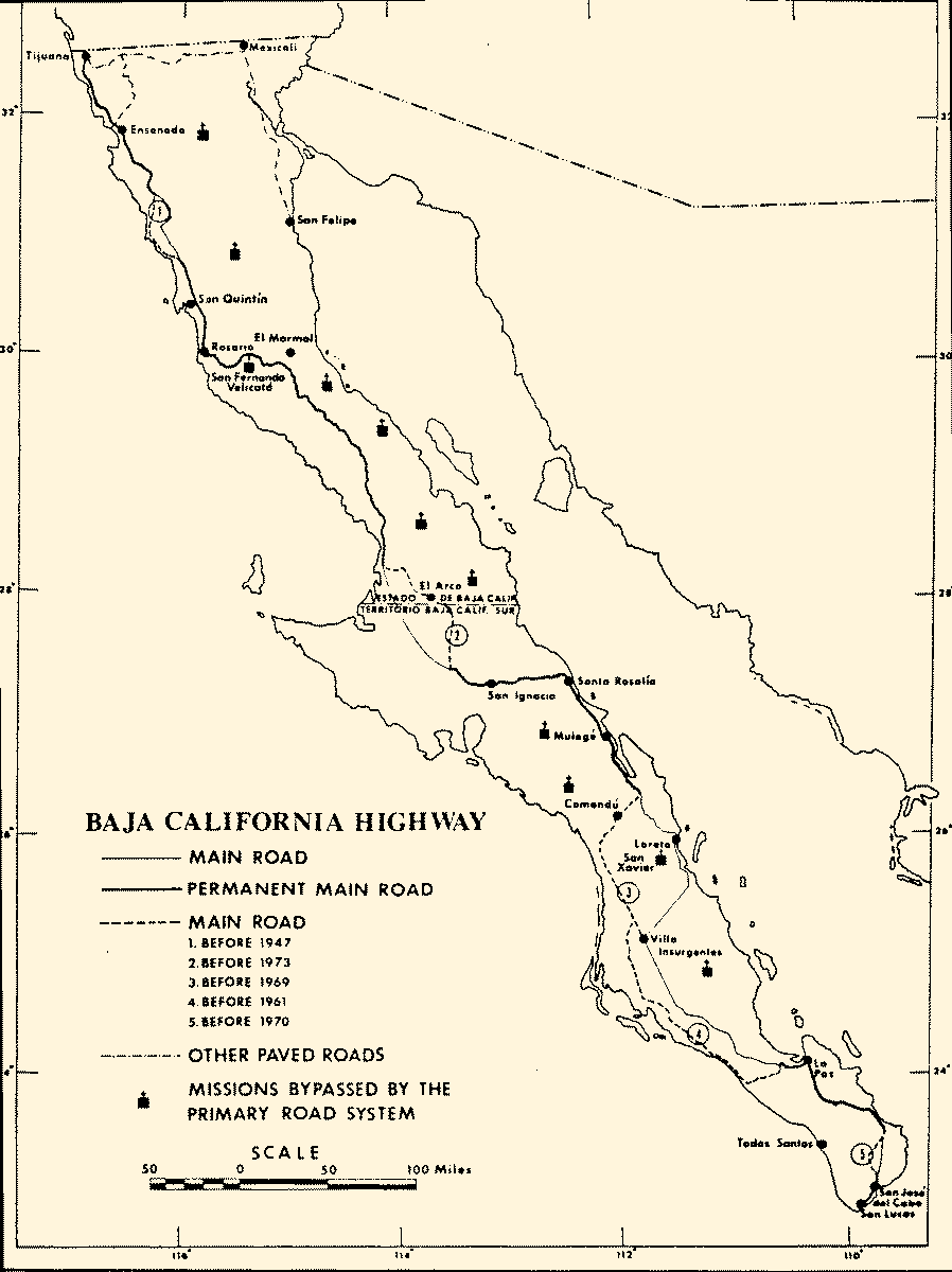
If you click the link (above the map) you can read about his road building research... Here that is, but maybe not as well to read as the original:
European settlement of Baja California began in 1697 with the founding of a Jesuit mission in Loreto. Until their expulsion in 1768 the Jesuits
extended a chain of missions over the southern two-thirds of the peninsula to Santa Maria, their last one, founded in 1766. Their Franciscan
successors, with far greater governmental support, given for geopolitical reasons, founded a mission at San Fernando Velicatá and pushed on overland
to San Diego whence the California mission system was extended. Baja California thus served as a strategic corridor to the frontier province up which
personnel, livestock, plant propagating materials, tools, and church furniture were carried. It was regarded as a more secure route than the one by
sea against strong northwest winds and a south-setting current. Briefly, from 1775 to 1781, another overland route from Sonora was used, but that was
cut by the successful Yuma Indian revolt.
In 1773 Baja California was transferred to the Dominican order which missionized the gentile Indians of the Frontier between San Fernando Velicatá
and San Diego and tended the declining older Jesuit establishments through the end of Spanish colonial times and into the period of Mexican
independence. Records are less abundant in the first half of the 19th century than in earlier mission times, but until after the middle of the latter
century there is no report of wheeled vehicles or roads for them anywhere in the peninsula. Note 1 Transport was exclusively along mule trails, a
network of which came to connect widely spaced missions and other oasis settlements and ranches. Less affected by accidental topography than roads,
these trails run fairly directly between points of interest. In rugged, subsequently abandoned regions, as around Mission Santa Maria, they can still
be followed.
A backwash from the California gold rush brought a wave of prospectors into Baja California, and by 1870 a number of successful gold, silver, and
copper mining properties had been located as well as a myriad of unsuccessful ones. For a time even high grade copper ores were hauled as much as 50
kilometers to coastal landings on muleback, as from Mina de San Fernando near San Fernando Velicatá, to the coast at San Carlos. Note 2 The need for
heavy equipment such as boilers and stamp mills, however, was an inducement to construct wagon roads to coastal points, and once they had been
established other mines would tie into them. By 1910 the peninsula had a broken net of mine roads, especially in the Northern Territory. Note 3
The development of irrigated agriculture in the Mexicali Valley, the accession of the powerfully independent and locally interested Governor Esteban
Cantú (1915-20), and the advent of Prohibition in the United States combined to accelerate economic development in the northern part of Baja
California. Cantú constructed engineered roads across difficult terrain from Mexicali to Tijuana and from Tijuana to Ensenada. Trucks and cars were
available duty-free from across the border. Ranchers and farmers in the valleys and uplands north of San Quintin found or constructed tracks that were
passable, at least in dry weather, in a widespread net.
In 1920 the geologist, Carl H. Beal, made an extensive reconnaissance of the peninsula for Marland Oil Company of Mexico seeking promising sites for
petroleum drilling. The results of his work were not published until 1946, Note 4 with a map which includes his amazingly extensive itinerary, most of
it followed by pack train. In January, 1922, apparently at the request of the U.S. military district in San Diego, still interested in Baja California
as a hangover from World War I, he prepared a 27-page single-spaced typescript entitled "Baja California-Route Studies." Note 5 In it he identifies
all the sections a wheeled vehicle might traverse, noting some wagon roads that an automobile should not attempt. He concludes that an automobile
might be able to travel from Tijuana to the onyx mine at El Marmol, though evidently wagons were used to transport the onyx at that time. The road
from Tijuana to Mexicali was established, and from it a number of passable tracks connected many of the ranches and mines on the relatively level
plateau of the Sierra Juarez. The track south from Mexicali to San Felipe was passable at some times but carried so little traffic that someone stuck
in the sand might die of thirst.
Farther south some disconnected roads from mine to coastal embarcation were noted. The most extensive set had been built by the El Boleo copper mine
radiating out of Santa Rosalia. Only the one connecting that town with Mulegé, however, was passable, others having been washed out and not repaired.
Finally, two passable roads led south from La Paz to Todos Santos on the Pacific Coast and to San José del Cabo at the tip of the peninsula. For both
roads and trails he is meticulous in noting where water can always be or only sometimes be obtained, commenting further on its quality. The
uncertainty, even danger, involved in traversing the peninusla is implicit.
General and ex-President Abelardo Rodriguez, who became governor of the Northern Territory in 1923, constructed the first paved road, from Tijuana to
Ensenada. Even earlier road construction began in the Southern Territory of Baja California with a road pushed to Magdalena Bay in 1921 and others
southward to Todos Santos and San José del Cabo. With its widely scattered intensively cultivated oases, the Southern Territory's road building
followed the classic pattern. If the terrain obstacles were not too severe, roads would be built to tie together the settlements, following the
topographically easiest course, but accepting detours if minor settlements could be brought into the system. Though his economic resources were far
smaller, the governor of the Southern Territory was able to tie Comondú to Mulegé in 1927, connecting with the system of the Boleo copper Company
which had independently laid roads south from Santa Rosalia to Mulegé and westward over the divide to San Ignacio.
The Automobile Club of Southern California and Governor Rodriguez, cooperating almost like sovereign powers, undertook to drive wheeled vehicles south
from San Quintin to connect with the road system of the southern Territory. In late 1926 an Auto Club group make it to Rosario, Note 6 and in 1927 a
combined expedition of the Mexican military, including the Governor, and the Auto Club drove to San Ignacio, then over the Boleo Company's roads to
Santa Rosalia and Mulegé. Mining roads were followed where they existed, routing the track back and forth across the peninsula. Note 7 In 1928 the
Auto Club installed its distinctive signs as far as Mulegé, noting mileages obtained in the previous years. Note 8 Random roadside vandalism,
intensified by Mexican nationalism that resents the foreign signs, has obliterated or removed all the signs where the road is still followed. A few
survive in spots infrequently visited.
For trucks or well equipped field vehicles the road was negotiable from Tijuana to Cabo San Lucas, but few tourists attempted it until after World War
II. Onyx was hauled north from El Marmol and Cerro Blanco, Note 9 and in the decade of the 1940's shark liver buyers sought all coves where fishermen
might put in. In the late 1940's out of season tomatoes were trucked from the Cape Region to the U.S. border; on a weekly schedule during the 1940's a
1932 Cadillac limousine carried mail and an amazing number of passengers from Tijuana to Santa Rosalia; some used passenger cars were driven from the
duty free border zone for sale in La Paz, and modest but growing numbers of adventurous American tourists pushed southward, many to write books about
their experiences. Note 10
In 1943 Ulises Irigoyen published in Mexico City a massive two-volume work on Baja California. Note 11 While it discussed the geography and history of
the region in not too accurate detail, as its title suggests the book was primarily a strong appeal to the Mexican national government to build a
paved highway the length of the peninsula. Such an enterprise would lead to economic development and strengthen the region's ties to Mexico. The
effects of the work were slow in emerging, but when in 1972 the national government did build the highway the expenditures were justified on the same
grounds.
During World War II the road had been paved south from Ensenada to Santo Tomas. In 1947 and 1948 a major project undertook to extend the paving to San
Quintin. Grading was accomplished that far, but funds for asphalt pavement were exhausted at San Telmo, some 75 kilometers short. For twenty years the
graded surface, becoming ever more washboarded and rutted, carried heavy truck traffic from the irrigation developments at Colonia Guerrero and San
Quintin.
In 1956 a remarkable individual road-making achievement was carried out. Arturo Gross, a part time miner, prospector, and mine promoter, and long a
resident of the Laguna Chapala and Calamajué district was offered 10,000 pesos ($800) by the State government if he could drive his truck up the East
Coast from Calamajué to San Felipe. Carrying a pick, shovel, and some blasting material he did it. Within weeks tourists followed with
four-wheel-drive vehicles. The northern part of the road has been improved, and now there are tourist fishing camps on the formerly completely
uninhabited coast.
Curiously, it was the Southern Territory, with far smaller economic resources than the Northern State, that sustained the impetus of road building and
improvement, both north and south of La Paz. Soon after 1950 a road was pushed south-westward from Loreto, until then accessible by road only from the
north, to join the main peninsular road at Santo Domingo. This road made Mission San Xavier, the outstanding example of Jesuit mission architecture,
accessible to tourists. A road was graded northward from La Paz to Villa Insurgentes by 1954, and paving proceeded steadily to the point by 1961. For
the next few years, repairing washouts caused by severe storms seems to have occupied the road-building resources of the Territory, but in 1968 a
major program paved the road south to San José del Cabo. At the same time a project was instituted to complete a paved road north from Villa
Insurgentes to San Ignacio, the most northerly oasis in the Southern Territory. A completely new alignment was chosen, crossing the uplands in an
east-northeasterly direction to reach the Gulf Coast south of Loreto. Grading preceded paving, often by a year or more, but work progressed steadily
and reached San Ignacio in 1972. Note 12
Extending the northern part of the paved road south from San Telmo did not begin until 1968 and in two years progressed only 20 kilometers, and in a
year and a half more, to early 1972, made only a like distance, though surveying and grading for a modern road had begun beyond San Quintin. Suddenly
the operation was accelerated; federal money became available, and two major contracts were let to grade and pave the entire 600 kilometer intervening
stretch to San Ignacio, working from each end. Hundreds of trucks and graders and thousands of laborers were employed. Various stages of construction,
from bulldozing a brecha to final hardening of roadside gutters in cuts, were carried on simultaneously over one-hundred kilometer stretches to hasten
essential completion of the highway by the end of 1973.
The heavy investment in the new highway is being justified by its attraction of vastly increased numbers of American tourists and the employment that
will be created in providing them with services. The American visitors prior to the paving of the highway have been of two classes, the drivers who
traveled slowly, enjoying the scenery and the nearly empty country, camping out and spending relatively little money; another group flew to luxury
resort hotels, particularly for fishing. The Mexican government's planning assumes that with a paved highway the additional drivers will seek and pay
for luxury hotel accommodations and several rather luxurious hotel-restaurants have been established at formerly unpopulated sites as well as new
hotels at established resorts such as Cabo San Lucas and Loreto.
The "Baja 1000 Rough Road Race" has attracted annually a further set of tourists, concerned to tear up the countryside rather than look at it. The
hope that the paved highway would end this desecration of the landscape was vain. In 1973 the race was run cross country on a newly staked out track.
It has been continued with completely new lineation but the course has been shortened to 500 kilometers.
Though it is only two lanes wide, less than ten meters in the least traveled middle of the route, the new highway was designed and built by modern
engineers given free rein. Curves are broad and gentle, grades are moderate, and visibility is generally good. Since water for construction was always
scarce and sometimes had to be hauled scores of miles, and ingenious, water sparing roadbed construction scheme was devised. Crushed gravel, sand, and
cement were mixed dry, spread and graded into place, sprinkled with water and then rolled. The resulting surface is smooth and hard though how it will
hold up will be determined in years ahead. The final surface is oiled and covered with fine gravel.
Except where the highway is actually cut into a hillside, it runs on top of an artificial ridge more than a meter high and only slightly wider than
the roadbed. To build this ridge, earth was scraped from as much as a hundred yards on both sides, destroying the vegetation, much of it unusual
endemic plants, and leaving a scar that will remain for decades if not for centuries. Protection against washouts rather than maintaining the wildly
beautiful desert environment clearly had precedence in the engineer's plans.
There are almost no places that a car can be stopped safely, and getting off the ridge on which the road rests is difficult and even dangerous.
Clearly the Baja California Highway will funnel tourists directly to the resort centers. Pausing to examine the extraordinary flora and the attractive
desert terrain, the features that attracted the driving tourist of the past, is discouraged and often made impossible. One could drive to La Paz
without being conscious of more than a long dull highway interrupted by a few settlements.
The alignment of overland transport routes in Baja California has changed in one rather consistent pattern from earliest historic times. The earliest
mule trails and probably their Indian trail predecessors went rather directly from water source to water source. These streams and tanks were
settlement sites, and in general are concentrated in the rugged uplands of the center and eastern edge of the peninsula. The mines which gave rise to
the first wagon roads tended also to be in the rougher country, but they sought the shortest and easiest route to the coast, either Pacific or Gulf.
The pattern of swinging back and forth across the peninsula that marks the original road for wheeled vehicles derives from two tendencies, the effort
to utilize the mining roads whenever feasible and seeking lower and leveler land. Water sources and settlements were still connected if possible, but
a number of oases that had held missions -- San Borja, Santa Gertrudis, Guadalupe, and San Xavier -- either long did without any road connection or
were tied to the main road by long, poorly maintained side tracks.
The new highway continues this trend. The biggest shifts in alignment involve staying far out on the flats of the Vizcaino desert almost to the
latitude of San Ignacio before heading east to that point, thus by-passing the former mining and trading centers of Calmalli and El Arco, and
following the Gulf coast well south of Loreto before crossing the drainage divide into the Magdalena Plains. The mission oases of La Purisima,
Comondú, and San Xavier are by-passed.
In its most recently completed sector, from Rosario to San Ignacio, the highway has been consistently displaced one to three kilometers west of the
old road except west and north of San Ignacio where there is a completely new alignment. All the tiny settlements along the old road that eked out a
precarious existence serving tourists have been by-passed as have some larger ones. In some instances, their residents have been able to move to a new
site on the highway, but this requires more capital than many possess. Further the new alignment, in contrast to the old, is not focused on hitting
the infrequent spots where water can be obtained.
Finally, the long term residents who have depended on tourists geared their services to the minimal requirements of the rough-road camper. The tourist
whom the new highway is designed to attract will be served by new entrepreneurs from Mexico City who will provide, at high prices, what might be found
in an American resort. Profits are going to the investors and managers imported from the mainland. Mexico's problems of underemployment and her need
to develop lucrative economic activities cannot be ignored. One can only hope that the benefits gained by the crassest touristic development of the
wild lands and shores of Baja California will be worth it.
Notes
It is possible that a wagon road ran over the 25 miles between the silver mines of Santa Ana and La Paz. The mines were opened in 1748 and worked
sporadically for several decades. No mention of such a road has been discovered, however. Zephyrin Englehardt, Missions and Missionaries in
California, Volume 1, Lower California, Santa Barbara, 1929. The drawings of Fr. Ignacio Tirsch, presumably describing Baja California in 1767, the
time of the Jesuit expulsion, offer two views of San José del Cabo, Plates VIII and IX, and several other scenes in the Cape area. San José is shown
as a busy port, but the paths in and out of town are only for riding animals, and many of them, but no wheeled vehicles appear in his several scenes.
The Drawings of Ignacio Tirsch: a Jesuit Missionary in Baja California. Narrative by Doyce B. Bunis, Jr. Translation by Elsbeth Schulz-Bischof,
Dawson's Book Shop, Los Angeles, 1972.
Return to citation
Homer Aschmann, "Recuperación de la vegatación desertica," Calafia, Vol. 3, No. 3 (Oct. 1976), pp. 52-57.
Return to citation
Jorge Engerrand and Trinidad Paredes, "Informe relativo a la parte occidental de la región Norte de la Baja California" in "Memoria de la Comisión
del Instituto Geológico de México que exploró la región Norte de la Baja California." Parergones del Instituto Geológico de México, Vol. 4,
1913, pp. 277-306.
Return to citation
Carl H. Beal, Reconnaissance of the Geology and Oil Possibilities of Baja California, Mexico, Geological Society of America, Memoir 31, 1948.
Return to citation
A copy of the typescript, evidently the original, is in my possession.
Return to citation
"Report of the trip made by C. B. Salisbury and J. E. McLean of the Automobile Club of Southern California from Los Angeles into Lower California for
the Purpose of Ascertaining Road Conditions as well as Outing and Hunting Possibilities, and to Take the Necessary Notes and Data with which to
Compile a General Map, Particularly of the West Coast Portion." (1926) Automobile Club of Southern California, Los Angeles.
Return to citation
Personal communication from G. P. Parmalee, Automobile Club of Southern California, retired.
Return to citation
Manuscript of lecture given by G. P. Parmalee, June 1967, entitled "History of Road Signing in California."
Return to citation
Personal communication from Paul Jacot of San Diego, California who trucked onyx for his father's mine in the 1940s.
Return to citation
Reference must be made to the Baja California Guidebook by Peter Gerhard and Howard E. Gulick, Arthur H. Clark Co., Glendale, Calif. four editions
beginning in 1956. With its accurate discussions of road conditions and mileages to the tenth of a mile, becoming lost -- even on side roads in
uninhabited areas -- was no longer an unavoidable risk.
Return to citation
Ulises Irigoyen, Carretera Transpeninsular de la Baja California. Editorial America, Mexico, 1943, 2 vols.
Return to citation
The dates are from my own observations and personal communications from Howard E. Gulick of Glendale, California.
Return to citation
|
|
|
David K
Honored Nomad
Posts: 65492
Registered: 8-30-2002
Location: San Diego County
Member Is Offline
Mood: Have Baja Fever
|
|
Harald, should anything happen to the links to Homer's notes or map, I have preserved them on VivaBaja.com in the Maps section at 1973 in the list. https://vivabaja.com/maps/
|
|
|
BajaBlanca
Select Nomad
Posts: 13247
Registered: 10-28-2008
Location: La Bocana, BCS
Member Is Offline
|
|
Wow, this is a great post and the memory of the moondust will never disappear from my mind as long as I am alive! It was so scary.
Paco: got any more stories?
|
|
|
4x4abc
Ultra Nomad
Posts: 4455
Registered: 4-24-2009
Location: La Paz, BCS
Member Is Offline
Mood: happy - always
|
|
what is moon dust?
Harald Pietschmann
|
|
|
chippy
Super Nomad
Posts: 1797
Registered: 2-2-2010
Member Is Offline
|
|
Drive from Puerto Chale to Punta Conejo offroad and you will find out . PS
The 1000 used this route and the moon dust was knee deep in some spots when I drove it in June 2022. . PS
The 1000 used this route and the moon dust was knee deep in some spots when I drove it in June 2022.
[Edited on 7-16-2022 by chippy]
|
|
|
4x4abc
Ultra Nomad
Posts: 4455
Registered: 4-24-2009
Location: La Paz, BCS
Member Is Offline
Mood: happy - always
|
|
moon dust - silt?
Harald Pietschmann
|
|
|
4x4abc
Ultra Nomad
Posts: 4455
Registered: 4-24-2009
Location: La Paz, BCS
Member Is Offline
Mood: happy - always
|
|
got it:
https://en.wikipedia.org/wiki/Fech_fech
Harald Pietschmann
|
|
|
David K
Honored Nomad
Posts: 65492
Registered: 8-30-2002
Location: San Diego County
Member Is Offline
Mood: Have Baja Fever
|
|
We used to call it simply "Baja dust" but it was after our experience the first time at Laguna Chapala, north of the ranch and lakebed. It was a bowl
of fine, talc-like dust... most call silt today.
When you entered this dust bowl, your Jeep would disappear as the silt would envelope your car and you drove blind until arriving at the ranch.
Past the ranch was the dry lake bed which allowed you to open it up to highway speed for a couple of miles to blow the Chapala dust off!
|
|
|
AKgringo
Elite Nomad
Posts: 6329
Registered: 9-20-2014
Location: Anchorage, AK (no mas!)
Member Is Offline
Mood: Retireded
|
|
I hit one of those silt beds right after the 2021 Baja 1k had run through a trail near Chapala. I had been climbing a moderate grade that was beat
up, but fairly firm until I crested over a rocky ridge.
I was driving in the opposite direction of what the race had run and did not notice a deep, soft, dry silt pit until I dove into it and a wave of dust
completely covered my windshield!
Everything under the hood was completely covered, and my air filter was at maximum load, but I had a spare.
Edit; I just read DK's post, and that was near where I was, but up on the ridgeline and probably east of where he was.
[Edited on 7-17-2022 by AKgringo]
If you are not living on the edge, you are taking up too much space!
"Could do better if he tried!" Report card comments from most of my grade school teachers. Sadly, still true!
|
|
|
David K
Honored Nomad
Posts: 65492
Registered: 8-30-2002
Location: San Diego County
Member Is Offline
Mood: Have Baja Fever
|
|
Chapala Silt Bed, 1965
This was it... and you see the ranch in the distance, left by hill? Well, you pointed to the ranch and then just dropped into the 'liquid' (well it
acted like liquid) as it fully covered your vehicle. The dry lake bed is beyond, over to the right.
Photo from Howard Gulick... a year before my folks and I drove this...

In 1973 (July), the new highway was under construction and went around the west side of the valley, avoiding the silt bed and dry lake... However, as
we found out the Chapala silt was all over the valley! My dad sold his 4x4 and bought this Ford wagon thinking the highway was all but finished... it
was not! He asked me to get up onto the new roadbed and take a photo of his wagon in the Chapala dust, on the detour road alongside the new highway.

|
|
|
| Pages:
1
2
3 |
|