| Pages:
1
2
3 |
TMW
Select Nomad

Posts: 10659
Registered: 9-1-2003
Location: Bakersfield, CA
Member Is Offline
|
|
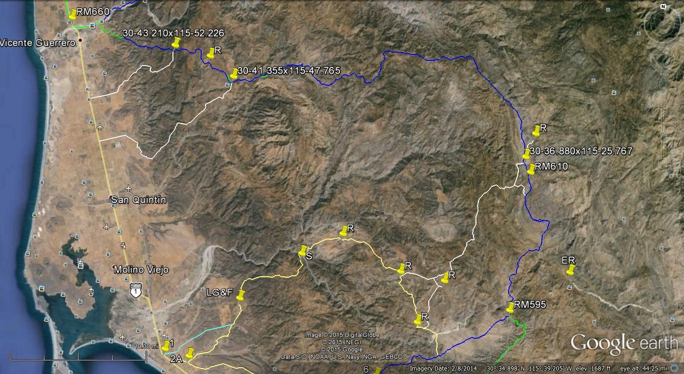
On this GE image I show a couple of race miles from the 2013 B1K. Note on the right side is RM610 and at the upper left at the Vicente Guerrero bridge
is RM660. I show two access roads from Hwy 1 to the race course. They were the only two I saw except when you get closer to the top. I also marked the
ranches I could spot on GE. There are trails to the east of the race course but either circle back or deadend.
|
|
|
bajatrailrider
Ultra Nomad
Posts: 2553
Registered: 1-24-2015
Location: Mexico
Member Is Offline
Mood: Happy
|
|
When you went this route did you pass Nvevo York.We rode from SQ 12 years ago North looking for Nvevo York,We passed only one Rancho.Live
stock,trucks,but no one home(Out on horse,we figure) No sign.So dont know if that rancho,it was a rocky road.That beat us all the way.
|
|
|
bajatrailrider
Ultra Nomad
Posts: 2553
Registered: 1-24-2015
Location: Mexico
Member Is Offline
Mood: Happy
|
|
Quote: Originally posted by motoged  | BTR,
We did that ride in January 2009....saw no one between EL Rosario and San Quintin....a few fresh bike tracks closer to SQ....the ride up onto the
sand dunes south of SQ and beach ride to SQ was a nice finish to a great ride....
Best rides to you.... |
HA HA that was probably me and Mikes tracks. Are you still riding Motoged,happy
trails
|
|
|
David K
Honored Nomad
Posts: 65562
Registered: 8-30-2002
Location: San Diego County
Member Is Offline
Mood: Have Baja Fever
|
|
Has anyone been to San Isidoro, other than on foot or hoof?
|
|
|
TMW
Select Nomad
Posts: 10659
Registered: 9-1-2003
Location: Bakersfield, CA
Member Is Offline
|
|
In the GE image above at the coordinates that read 355x115 just above the last 5 a road goes north for bout 2 miles to a Y. The left fork goes to a
Ranchoin about 1/2 mile that by the coordinates in the almanac that is Nueva York.
|
|
|
TMW
Select Nomad
Posts: 10659
Registered: 9-1-2003
Location: Bakersfield, CA
Member Is Offline
|
|
David where is San Isidoro in the almanac?
|
|
|
bajatrailrider
Ultra Nomad
Posts: 2553
Registered: 1-24-2015
Location: Mexico
Member Is Offline
Mood: Happy
|
|
| Quote: Originally posted by TMW | | In the GE image above at the coordinates that read 355x115 just above the last 5 a road goes north for bout 2 miles to a Y. The left fork goes to a
Ranchoin about 1/2 mile that by the coordinates in the almanac that is Nueva York. |
Thank you TMW I will
look.
|
|
|
David K
Honored Nomad
Posts: 65562
Registered: 8-30-2002
Location: San Diego County
Member Is Offline
Mood: Have Baja Fever
|
|
2009 Baja Ca Almanac

EL CAMINO REAL MAP
|
|
|
TMW
Select Nomad
Posts: 10659
Registered: 9-1-2003
Location: Bakersfield, CA
Member Is Offline
|
|
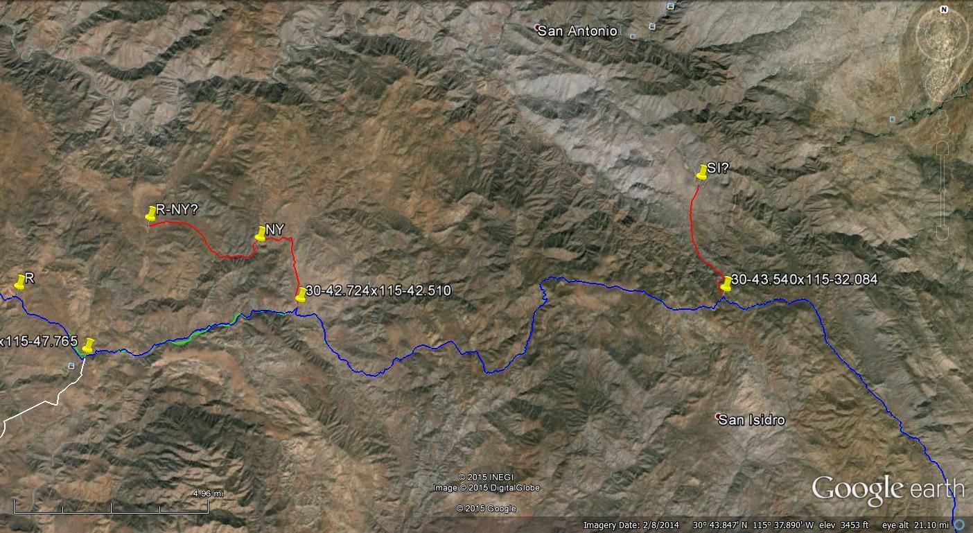
Here is a GE image that shows what I think is Nueva York as per the coordinates from the almanac. The pin NY is just a building and further west at
pin R-NY? there are several buildings so I think it is actually the ranch.
The pin SI? to the right is where San Isidoro should be from the almanac coordinates but GE does not show any building etc. The trail does come to an
arroyo like it shows in the almanac. Maybe Bing will show something. Of course it may no longer exist.
|
|
|
TMW
Select Nomad
Posts: 10659
Registered: 9-1-2003
Location: Bakersfield, CA
Member Is Offline
|
|
Bing show the SI pin to be at arroyo Campo del Oso which is what the almanac shows.
|
|
|
David K
Honored Nomad
Posts: 65562
Registered: 8-30-2002
Location: San Diego County
Member Is Offline
Mood: Have Baja Fever
|
|
Graham writes about San Isidoro on his Journey With a Baja Burro from his 1997 walk to Loreto. It was a visita on the Vamino Real to Mission San Pedro
Martir. Kevin photograped some artifacts there by the abandoned rancho.
|
|
|
bajatrailrider
Ultra Nomad
Posts: 2553
Registered: 1-24-2015
Location: Mexico
Member Is Offline
Mood: Happy
|
|
Wow did you guys see up rt hand corner San Antonio.Four of us went down there 12/14 years ago.On dirt bikes.Mellings do pack mule trip down
there.There is a solar cabin down there,grave yard.A Family lived there many moons ago.Its very green lots of blue water.I dont recommend anybody try
to ride a bike down.Like we did.Also I was told two years ago.By the Mellings,there is new road by San Isidoro.
|
|
|
Ken Cooke
Elite Nomad
Posts: 8971
Registered: 2-9-2004
Location: Riverside, CA
Member Is Offline
Mood: Pole Line Road postponed due to injury
|
|
How close would this new road take a 4WD to Mision San Pedro Martir?
|
|
|
bajatrailrider
Ultra Nomad
Posts: 2553
Registered: 1-24-2015
Location: Mexico
Member Is Offline
Mood: Happy
|
|
I have not been on that road,but new road from Coyote.All the way up in forest(just below park gate. Is gated both ends,I have the keys for gates.
|
|
|
David K
Honored Nomad
Posts: 65562
Registered: 8-30-2002
Location: San Diego County
Member Is Offline
Mood: Have Baja Fever
|
|
Hi guys... just back home...
Ken, there is still a hell of a climb from San Isidoro up to the mission. It is an El Camino Real trail up the side of a mountain... You can barely
see it on Google Earth.
The new road is the one TW and Roy are going on (I think he said Roy?) which is a Baja 1000 route in the foothills of the sierra from Rancho Nueva
York down to Rosarito and reaches Hwy. 1 at Los Martires turnoff/ cafe (also called El Arenoso airstrip).
I will make a map to point it all out... and give the distances fro the road to San Isidoro and up to the mission.
|
|
|
David K
Honored Nomad
Posts: 65562
Registered: 8-30-2002
Location: San Diego County
Member Is Offline
Mood: Have Baja Fever
|
|
Speaking of Mission San Pedro Mártir...
Want a sneak peak at the chapter on that mission from my new book?
It is not formatted correctly here, but will give you an idea of the kind of data my next book will provide to help all interested in knowing more
about the history of Old California...
#24 San Pedro Mártir de Verona (1794-1811)
By the end of 1791, the first five Dominican California missions were established along El Camino Real, securing the corridor between the peninsula
and San Diego. The interior could now be brought under Dominican influence with mountain missions. The Indian attacks would be halted by
Christianizing the heathens, or so the Spanish government believed.
The northern Baja California mountain valleys and meadows were first explored by José Velázquez in November 1775. Velázquez was ordered by Governor
Neve to explore the northern gulf coast for a port closer than the Bay of San Luis Gonzaga to serve the new Dominican missions. Velázquez traveled
north for two days from Mission San Fernando found many Indians and pine forests. He climbed a mountain and saw the Colorado River and the surrounding
desert but never left the sierra for the uncertainty of finding drinking water. Velázquez feared the river would be still contaminated with sea water
where they could reach it. Even though the goal of the expedition was not met, Velázquez did spark a desire of the Dominicans to establish a mission
in the higher elevations of Baja California.
In May 1793, Californias Lieutenant-governor José Joaquín de Arrillaga, in Loreto, authorized an expedition to find potential mountain mission sites.
Two sites were found to be the most suitable. One was northeast of San Vicente near a pass (El Portezuelo) leading to the Colorado River. The other
mission site was east of Mission Santo Domingo in a high mountain meadow. In a letter dated January 15, 1794, Arrillaga stated that Mission San Pedro
Mártir would be founded east of Santo Domingo that April.
Mission San Pedro Mártir de Verona was established on April 27, 1794, by Padre Caietano Pallás with Padre Juan Pablo Grijálva and Padre José Loriente.
The first site for the mission was a place known to the native Kiliwa Indians as Casilepe and is a meadow, today called La Grulla. It was at an
elevation of 6,785 feet. The exact location was unknown until an expedition in 1991 revealed cut stone foundation blocks in a pattern and scale that
was of European origin. Some sixty Kilawa Indians joined the mission in its beginning.
Less than three months passed before a location change was requested. On July 18, 1794, Padre Pallás wrote the following to Governor Borica: The new
foundation has not continued with the happiness with which it began. The crops have frozen and I have determined to move it to work at another place,
situated on the western slope of the Sierra about three leagues distant from the other.
On July 19, 1794, Padre Pallás wrote: The missionary at San Pedro Mártir says he will move the week that now ends, because of frosts and annoyances.
On July 29, Pallás requested permission to execute the transfer from Casilepe to the location known to the Kilawa natives as Ajantequedo. Governor
Borica responded on August 10 to permit the transfer to a more fertile and sheltered site. The second mission site is seven miles south and over 1,700
feet lower in elevation than the first.
The mission was in a region where the Kiliwa Indians only visited seasonally. A large workforce was not easy to assemble without a permanent local
population. The complex at Ajantequedo was large and mapped out by Peveril Meigs during his field work on the Dominican missions in 1926. It resembled
a fort with defensive walls for protection. Water for mission crops came from springs on opposite sides of the valley and above the stream. Canals
were built from the two springs and both ran for a half mile to the fields and to the mission. In 1926, Meigs found the mission floors were partly
tiled with red nine inch square bricks, and pieces of red roof tiles were abundant. Meigs stated that San Pedro Mártir was a highly developed,
picturesque, and unique mission. The elevation at the second site is 5,060 feet above sea level, making it the highest Spanish California mission.
In 1794 Sergeant José Manuel Ruiz wrote of the building of two bulwarks (fortifications) with cannon embrasures (openings). Ensign Alférez Bernal had
been sent from San Vicente to San Pedro Mártir in May 1796 to investigate an incident. Bernal found that some soldiers were wounded and some Indians
killed in a skirmish. Governor Arrillaga left Loreto by boat in June 1796 for Bahía San Luis Gonzaga then traveled by land to Mission San Vicente.
Arrillaga wrote in August 1796 that there was additional trouble with Indians escaping. While at San Vicente, Arrillaga learned that the neophytes
of San Pedro Mártir had deserted and demanded that a new padre be assigned to them.
By 1800, the population had grown to only ninety-two. The primary crop was corn, but raising cattle was the most productive endeavor for this mission
thanks to the extensive pasturelands nearby. In 1801, a new church made of adobe 17 feet by 69 feet and a long reception room 39 feet by 19 feet were
constructed. Also, two rooms each 19 feet by 22 feet and a storage room 19 feet by 33 feet were built. Sometime after 1801, the mission fell into
decline. The lack of surviving records makes the cause for decline open to speculation.
In 1808, Padre Ramón López wrote a report on the status of all the peninsula missions. In it he states, The two missions in the hills, Santa Catalina
and San Pedro [Mártir], cannot give what they dont have. The minister at Santa Catalina formerly was able to send something, but now he struggles
just to make ends meet. San Pedro [Mártir] is good for little more and likely will always be that way. From this report, we learn that the mission
existed at least until 1808. The mountain mission, from which the entire range is named after, operated for probably less than twenty years. The
remaining neophytes were transferred down to Mission Santo Domingo and nothing more is known of its end or the exact year it closed. One research
paper states that an especially cold winter closed the mission in 1811. Padre Mansilla of Santo Tomás has an entry in the San Pedro Mártir mission
book of records in 1846, which is most curious and has caused some rumors about Dominican gold since there are old mines and mill stones (arrastras)
in the area.
San Pedro Mártir is one of only two California missions not accessible by automobile. A two or three-day backpack hike or mule ride is required to
reach the site. The usual approach is east from Rancho Santa Cruz through San Isidoro or south from La Tasajera through La Grulla.
The following articles give additional details on this most remote of the California missions:
John Robertson, 1966 (page 39): http://dezertmagazine.com/mine/1966DM08/index.html
John Foster, 1991: http://www.pcas.org/Vol33n3/333fostr.pdf
Max Kurillo, 1996: http://www.pcas.org/Vol33N3/333Krilo.pdf
Dominican Missionaries recorded at San Pedro Mártir:
Caietano Pallás, Pablo Grijálva, and José Loriénte Apr. 27, 1794
Rafaél Caballero 1794-1797
Antonio Caballero 1794-1797
Juan Ríbas 1797
Mariano Apolinário 1797-1798
José Caulas 1798
Miguel López 1798
José Loriénte 1798
Eudaldo Surroca 1803
José Portela 1806
Juan Ríbas 1806
Ramón de Santos 1806
|
|
|
David K
Honored Nomad
Posts: 65562
Registered: 8-30-2002
Location: San Diego County
Member Is Offline
Mood: Have Baja Fever
|
|
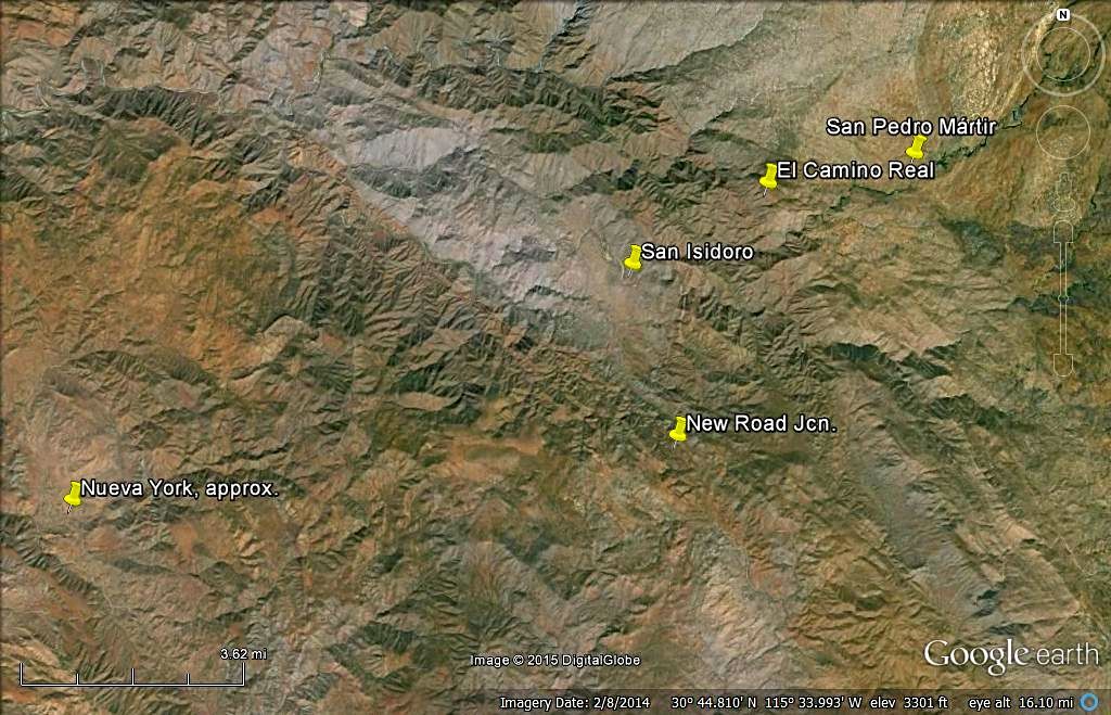
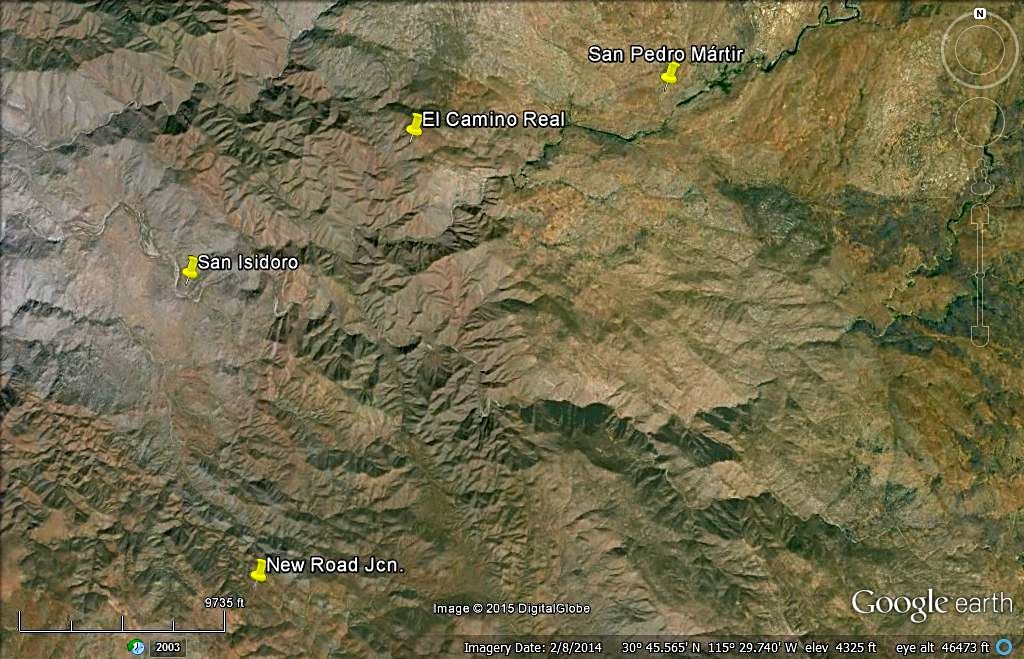
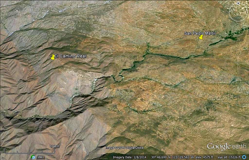
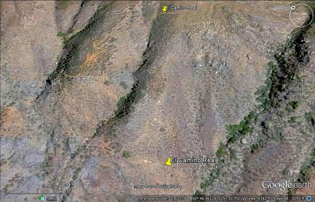
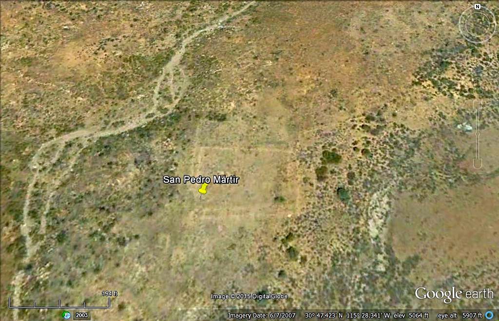
In looking at the latest Google Earth images, it appears that a road now goes to San Isidoro from the new sierra foothills road. It actually seems to
end on the south side of the creek, across from where the mission visita and old ranch was?
Here are six images showing the overall area, then zooms in. Most have N at top. I added a second ECR pin near the bottom of the cuesta.
Note the scale bar at the bottom for distance estimates.

|
|
|
bajatrailrider
Ultra Nomad
Posts: 2553
Registered: 1-24-2015
Location: Mexico
Member Is Offline
Mood: Happy
|
|
When we went on our Bike trip,two weeks ago.We did not get chance to Explore route.From Vicente to San Quintin.The first weekend of Dec,we attempt it
again.This time park trucks,at friends home in Vicente.Unload dirt bikes.Anyone with 4x4/dirt bike welcome. As far as new road around San
Isidoro.Alfredo Meling at Rancho Coyote has this info.
|
|
|
David K
Honored Nomad
Posts: 65562
Registered: 8-30-2002
Location: San Diego County
Member Is Offline
Mood: Have Baja Fever
|
|
| Quote: Originally posted by bajatrailrider | | When we went on our Bike trip,two weeks ago.We did not get chance to Explore route.From Vicente to San Quintin.The first weekend of Dec,we attempt it
again.This time park trucks,at friends home in Vicente.Unload dirt bikes.Anyone with 4x4/dirt bike welcome. As far as new road around San
Isidoro.Alfredo Meling at Rancho Coyote has this info. |
In the third sat image above (close up at San Isidoro) you can see the road coming in from the south to the creek. This is about 3 miles or less north
from the new-ish Sierra road... where there is now quite a pull-off at a sharp curve, where the new San Isidoro road heads north. It would be great to
confirm if this is a drivable road. It would knock a day's hike off the mission trip, perhaps? Previously, Rancho Santa Cruz, south from El Potrero,
southeast of Meling Ranch was the closest vehicle approach... over 10 hiking miles away.
|
|
|
bajatrailrider
Ultra Nomad
Posts: 2553
Registered: 1-24-2015
Location: Mexico
Member Is Offline
Mood: Happy
|
|
You dont need hike up to San Isidoro.My freinds own Santa Cruz/El Potrero. If you can ride a horse David,consider it done.
|
|
|
| Pages:
1
2
3 |


