| Pages:
1
2
3
4 |
4x4abc
Ultra Nomad
    
Posts: 4454
Registered: 4-24-2009
Location: La Paz, BCS
Member Is Offline
Mood: happy - always
|
|
Quote: Originally posted by leo_jb  | I got some tracks from 4x4ABC dated March of this year. These appear to be actual recorded tracks, not converted routes or some such. Is that
correct?
Tom - thanks for the very generous offer. We may very well take you up on it, and will certainly keep you posted via this thread. I also will be
bringing a Delormen Inreach, which allows email via satellite. Having a local email contact would be awesome.
Captain Olives? WTF?
|
yes, my tracks are live recordings. No armchair exploring. I had to work from memory, that's why we we off on occasion in Arroyo La Trinidad.
So, in short it's the 2 Arroyos that are torn up : La Trinidad and Santa Barbara. Unless you are really adventurous and go for La Fortuna. We did it
with 4x4 a couple of years back. Memorable.
https://carlosnpainter.smugmug.com/Events/La-Fortuna/i-9KQXZ...
Harald Pietschmann
|
|
|
captain.olives
Newbie
Posts: 24
Registered: 11-13-2009
Location: NorCal
Member Is Offline
|
|
Gin martini, shaken to the point of bruising, two olives. I can sip it with out spilling while holding the tiller in 25 knots... so yes Captain
Olives! 
Its going to big an epic trip this year!
|
|
|
leo_jb
Newbie
Posts: 19
Registered: 10-28-2015
Member Is Offline
|
|
Quote: Originally posted by 4x4abc  | Quote: Originally posted by leo_jb  | I got some tracks from 4x4ABC dated March of this year. These appear to be actual recorded tracks, not converted routes or some such. Is that
correct?
|
yes, my tracks are live recordings. No armchair exploring. I had to work from memory, that's why we we off on occasion in Arroyo La Trinidad.
So, in short it's the 2 Arroyos that are torn up : La Trinidad and Santa Barbara. Unless you are really adventurous and go for La Fortuna. We did it
with 4x4 a couple of years back. Memorable.
https://carlosnpainter.smugmug.com/Events/La-Fortuna/i-9KQXZ...
|
Damn. Now I have to re-read everything again. I was under the impression that the La Fortuna wash was the easy route. Maybe it was before the
hurricane? BTW, my instinct says we're going to go for it. Thanks to you.

|
|
|
4x4abc
Ultra Nomad
    
Posts: 4454
Registered: 4-24-2009
Location: La Paz, BCS
Member Is Offline
Mood: happy - always
|
|
La Fortuna wash became "impassable" - isn't that when the fun starts?
A bypass was built for the Santa Barbara folks.
Odile in 2014 destroyed Arroyo Santa Barbara. Not effecting the ranch folks much. But no more road to San Miguel.
I would chose La Fortuna wash - it's much shorter.
Her some before and after images of La Fortuna wash 2003-2006
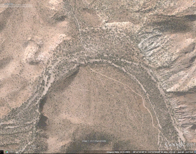
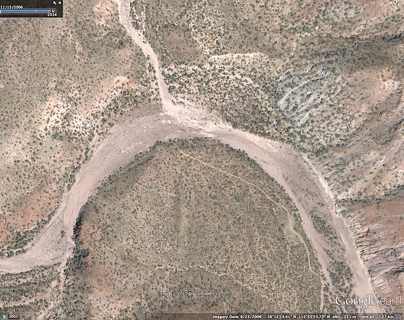
Harald Pietschmann
|
|
|
4x4abc
Ultra Nomad
    
Posts: 4454
Registered: 4-24-2009
Location: La Paz, BCS
Member Is Offline
Mood: happy - always
|
|
here is the devastation in Arroyo Santa Barbara after hurricane Odile in 2014
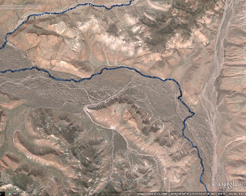
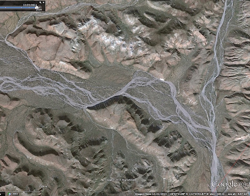
Harald Pietschmann
|
|
|
4x4abc
Ultra Nomad
    
Posts: 4454
Registered: 4-24-2009
Location: La Paz, BCS
Member Is Offline
Mood: happy - always
|
|
here is how it looked like on the ground - no trail visible for miles. All choices were bad choices. Both images in Arroyo Santa Barbara.

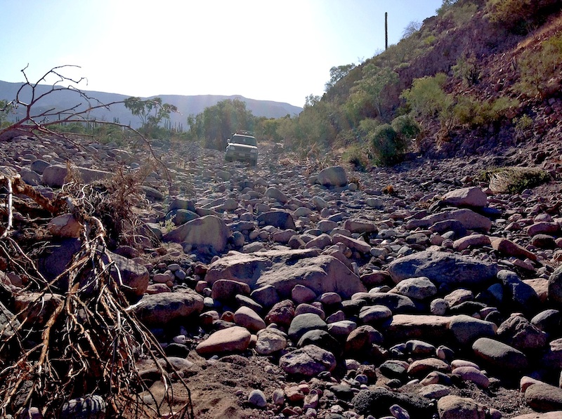
Harald Pietschmann
|
|
|
honda tom
Nomad
 
Posts: 493
Registered: 8-28-2003
Location: middle calif
Member Is Offline
|
|
What a tool.
|
|
|
4x4abc
Ultra Nomad
    
Posts: 4454
Registered: 4-24-2009
Location: La Paz, BCS
Member Is Offline
Mood: happy - always
|
|
Looks like a fun trip from Santa Barbara to Santa Gertrudis. Pretty steep stuff. Most likely no wheels will ever go there.
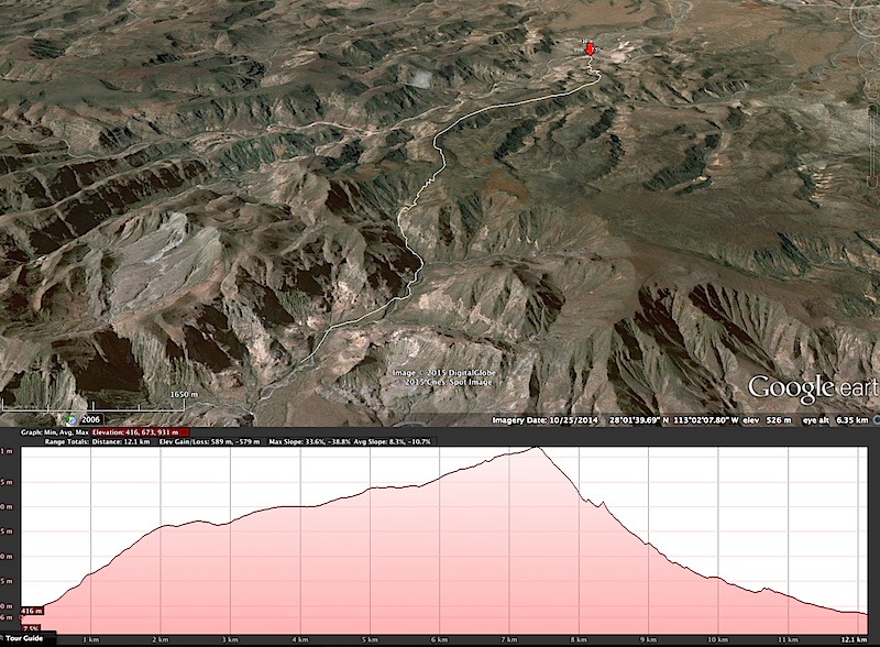
Harald Pietschmann
|
|
|
John M
Super Nomad
   
Posts: 1924
Registered: 9-3-2003
Location: California High Desert
Member Is Offline
|
|
La Fortuna Route
Leo - this information I'm passing along is from what we observed on the ground last January. I don't think I can attach a word document here or on
U2U so I've sent you a U2U message with my email address. Email me and I'll send the file to you.
On the top box of this Baja Nomad page, right side, you should see something that says "you have a U2U message". Click on that and when the message
opens, scroll down to "reply" and you can respond.
John
|
|
|
David K
Honored Nomad
        
Posts: 65412
Registered: 8-30-2002
Location: San Diego County
Member Is Offline
Mood: Have Baja Fever
|
|
Harald, that is a nice profile and satellite view of the mission road between Santa Gertrudis and Santa Barbara. Years ago, off road m/c rider/ racer
Kevin Ward (& Dust to Glory producer) had ridden it (as well as the Camino Real between Gonzaga and Mission Santa Marķa).
That was over 10 years ago... and things do indeed change!
|
|
|
TMW
Select Nomad
      
Posts: 10659
Registered: 9-1-2003
Location: Bakersfield, CA
Member Is Offline
|
|
Corky1 was always talking about riding from Santa Gertrudis to Santa Barbara on a MC. When the subject comes up I sometimes wonder if he ever did. If
he sees this he can chime in.
|
|
|
woody with a view
PITA Nomad
      
Posts: 15940
Registered: 11-8-2004
Location: Looking at the Coronado Islands
Member Is Offline
Mood: Everchangin'
|
|
....and when are you "officially" in said wilderness?
|
|
|
David K
Honored Nomad
        
Posts: 65412
Registered: 8-30-2002
Location: San Diego County
Member Is Offline
Mood: Have Baja Fever
|
|
Quote: Originally posted by lencho  | So in what way is it "wilderness" if one expects to be
rescued when things go south?
Lewis and Clark would laugh at today's he-man adventurers. 
|
If it had government maintained public roads in the area it would NOT be a "wilderness" trail... that is my point. Does ANYONE expect to get rescued
if they have a problem (in the "wilderness")? Perhaps now-a-days, with Spot and In Reach devices? I think people should enjoy our planet as much as
they wish... it is "our" planet, after all. Maybe more people, older people, handicapped people have some comfort to get outdoors because of modern
devices?
The point is, thanks to hard working private individuals, such as 4x4abc, these washed out or abandoned roads can still be used by a tiny few
individuals and they could provide a rescue to others who risk hiking far from civilization.
|
|
|
Desertbull
Senior Nomad
  
Posts: 558
Registered: 8-27-2003
Member Is Offline
|
|
Quote: Originally posted by mjs  | Bikes have been through this year. Cameron Steele did it on the Rip ride. He said they had to do a bit of bushwacking to get through and no 4 wheeled
chase vehicles. I would be interested in an updated track if you go this way.Have fun,
Mark |
You might check with Cam, pretty sure the 2015 R2C moto ride did NOT go thru No Wimps trail. In past trips when the DA ran through No Wimps they left
LA Bay at 5:00 am and got into San Ignacio 13 hours later...this year they left later in the morning and were at the San Ignacio mission early
afternoon. The YouTube R2C Day 4 video depicts that day. Check it out.
I've been through the No Wimps in my off-road equipped truck 8-10 times, but not since the storm went through there. As the moto guys know you have
to take gas...I've filled moto guys and some lost Gringos back there out of my Dodge with my 60-gallon auxiliary tank because they were not
prepared...its a long way and an awesome adventure. Last time we went we camped Punta Trinidad and BBQ'd fish from local fisherman that we traded for
a bottle of Tequila...everyone joined into the fray and it was a fun long night on the beach with a small bonfire.
As you guys know there are GPS routes, but it changes all the time. Best to go and figure it out for the time that you're going through. Using
another GPS route such as mine might be totally wrong at this time due to big changes from the storm.
A few gnarly sections are all deep sandy issues...once you pass the Corral and have to bonzai onto the deep shale and around the rocky cliff
point..the deep SHALE and SAND is very easy to get buried in. Keep up your speed and transition back to the top beach side slowly, don't hard right
turn back to the top of the beach or you may get stuck...then the tide comes in...and well you know the rest.
Another section was a deep wash that you have to go up away from the beach and then make a hard left turn up the 50' hillside and do this big climb
out of the wash.
Then finally after that you have to go through the Tidal Flats nearing Punta Trinidad...you will naturally WANT to go against the mountain but the
tidal mud is thick there...force yourself to stay on top of the crown where the beach sand ends and the tidal flats begin....lots of stuck spots from
previous adventurers buried there, but again keep up your momentum and don't stop.
Motos never have a problem for the most part, but the trucks do...take a set of MAXTRAX ... I'm not a MAXTRAX rep but I can tell you 100% they are
worth every bit they cost! They WORK!
Have fun! 
DREAM IT! PLAN IT! LIVE IT!
|
|
|
bajatrailrider
Ultra Nomad
    
Posts: 2511
Registered: 1-24-2015
Location: Mexico
Member Is Offline
Mood: Happy
|
|
The only thing scarred is
this marooons rear,from sitting on it.
|
|
|
mjs
Nomad
 
Posts: 333
Registered: 2-20-2013
Location: Off grid in San Felipe
Member Is Offline
|
|
DB, only know what Cameron told me. I wasn't on the ride. It may have been Hell Ride and not R2C.
Cheers,
Mark
|
|
|
captain.olives
Newbie
Posts: 24
Registered: 11-13-2009
Location: NorCal
Member Is Offline
|
|
Quote: Originally posted by Desertbull  | Quote: Originally posted by mjs  | Bikes have been through this year. Cameron Steele did it on the Rip ride. He said they had to do a bit of bushwacking to get through and no 4 wheeled
chase vehicles. I would be interested in an updated track if you go this way.Have fun,
Mark |
In past trips when the DA ran through No Wimps they left LA Bay at 5:00 am and got into San Ignacio 13 hours later... |
Thanks for info Desert Bull. I am going to check out the video for some Baja porn! 
Its also a good gut check for us. We are experienced riders and should be able to tackle any terrain. That said, for us non pro level riders its
going to be a question of how much challenging terrain we can endure and how much time we have to tackle the terrain.
We will spending the night in San Francisquito, so we will be that much closer... thats a plus. Plan to leave SF fully gassed with at least 5
gallons + of fuel. Another plus.
But honestly as you know, Bola to SF isnt that far and damn near a freeway of a dirt road. So it isnt going save us massive time as I am sure we will
be riding at a much more conservative pace on the NWT than the Rip participants. Accounting for NAV errors, tubes, challenging sections, and current
conditions..... not sure if we can do it in a day. 
If we can make Santa Marta by dusk, we can skip the trail through El Carricito and take the easy road to Ejido Alfredo.
We are supposed to meet the rest of the group that night in Mulege. The next day is a rest day for the group, so we could potentially spend a night to
attempt this trail or ride through the night via pavement. I hate riding on night... especially on the pavement.
Just thinking out loud.... Thank you to all who are contributing info! Is it January yet?
|
|
|
Mike Kay
Newbie
Posts: 13
Registered: 10-11-2015
Member Is Offline
|
|
Ive done NWT/Malcolm Trail/San Miguel to Tinidad to Rancho Gato to Santa Marta to San Ignacio a couple times on a moto, but not since the storm
damage. Lizardlady sells GPS tracks of the route. GPXchange also has some. Obviously things on the ground have changed/will always change.
We leave Bay of LA 7 am. Quick lunch and fuel in San Francisquito. Locals say there is a quy in El Barril who sells gas (back up).
Each time arrived San Ignacio around midnight.
Our next 8 day ride in Feb. will include this section.
Looking forward to your ride report! 
[Edited on 11-9-2015 by Mike Kay]
|
|
|
rts551
Elite Nomad
     
Posts: 6700
Registered: 9-5-2003
Member Is Offline
|
|
Quote: Originally posted by David K  | [rquote=
I think people should enjoy our planet as much as they wish... it is "our" planet, after all. Maybe more people, older people, handicapped people
have some comfort to get outdoors because of modern devices?
The point is, thanks to hard working private individuals, such as 4x4abc, these washed out or abandoned roads can still be used by a tiny few
individuals and they could provide a rescue to others who risk hiking far from civilization. |
Use it up because it is there? I don't get it.....some areas need to be set aside for future generations. It is everybody's planet...not just
yours.
|
|
|
David K
Honored Nomad
        
Posts: 65412
Registered: 8-30-2002
Location: San Diego County
Member Is Offline
Mood: Have Baja Fever
|
|
Not to worry Ralph, according to the religion you follow, all these trails improved by hard working four wheelers, like Harald and Tom, will be under
water from the rising sea level in a few years!
|
|
|
| Pages:
1
2
3
4 |

