| Pages:
1
2
3
4 |
leo_jb
Newbie
Posts: 19
Registered: 10-28-2015
Member Is Offline
|
|
No Wimps Trail and routes from Punta San Francisquito
A group of dirt bike riders from the SF Bay Area are planning a Baja trip in January and are looking at some more challenging routes south of Punta
San Francisquito. I've attached a screen shot from Mapa E32 showing three alternates. From west to east the routes are:
1) West from Punta SF towards El Arco, but then south through Miraflores to Vizcaino. This shows up as a "Ruta Offroad" on E32 and seems the easiest
option.
2) South from Punta SF along the No Whimps trail, then west towards Santa Barbara. The idea is to connect with the road coming from Miraflores to
Santa Gertrudis, but E32 shows nothing between S. Barbara and S Gertrudis. The Baja Almanac shows a "trail" which I assume is more of a cow or foot
trail than single track.
3) The No Wimps Trail. Also a "Ruta Offroad" in E32. There's a pretty good write-up elsewhere on this forum No Wimps Trail but any updates would be appreciated. Especially from any bikers that have gone through this year. Lack of fuel looks to be a
concern.
Any comments from people who have traveled these routes recently would be appreciated. Not sure if option #2 is even passable. No Wimps looks hard,
but doable if enough gas is carried and we don't screw up navigation or have a major injury or mechanical problem. All the riders are pretty
experienced Baja travelers.

|
|
|
TMW
Select Nomad

Posts: 10659
Registered: 9-1-2003
Location: Bakersfield, CA
Member Is Offline
|
|
#1 is no problem.
I've done the No Wimp Trail twice and we tried again last Jan. but the hurricane last year wiped out the area where the road split for Santa Barnara
and San miguel near the coast. Rancho Santa Barbara fixed a road to their place. It also messed up the La Trinidad arroyo where it comes off the coast
to El Gato. However a couple of Germans drove it in their G wagons along with a Jeep last March and it took them 4 days and had to do some road
building at each end to get thru.
They did provide a GE track where they went around the heavy damage at the beginning.
Motocycles should have a much easier go at it.
There is no road or even a MC trail between Santa Gertrudis and Santa Barbara. The road/trail goes east from the mission but fades away and I'm sure
the same rains that wiped out the NWT start also finished off any trail that may have existed. I would go to Rancho Santa Barbara and ask them to be
sure.
I can provide you with a lot of info for the No Wimp Trail and would like to see you do it and get it opened up again. It's a great ride/drive along
the coast.
I should add that Nomad 4x4ABC (Harald) is the one that did the NWT I spoke of above and he mentioned seeing a couple of MC tracks along the way.
[Edited on 10-29-2015 by TMW]
|
|
|
TMW
Select Nomad
Posts: 10659
Registered: 9-1-2003
Location: Bakersfield, CA
Member Is Offline
|
|
In April of 2014 we did a trip and the last part was taking the No Wimp Trail from San Ignacio to San Francisquito. Here is the report I did.
http://forums.bajanomad.com/viewthread.php?tid=73500
|
|
|
mjs
Nomad
Posts: 335
Registered: 2-20-2013
Location: Off grid in San Felipe
Member Is Offline
|
|
Bikes have been through this year. Cameron Steele did it on the Rip ride. He said they had to do a bit of bushwacking to get through and no 4 wheeled
chase vehicles. I would be interested in an updated track if you go this way.
Have fun,
Mark
|
|
|
David K
Honored Nomad
Posts: 65562
Registered: 8-30-2002
Location: San Diego County
Member Is Offline
Mood: Have Baja Fever
|
|
The Santa Gertrudis to Santa Barbara trail is a mission road (Camino Real branch) to bring in supplies from ships. You can see it easily on Google
Earth. However, the surface condition today could be impassable... you just can't tell from space!
|
|
|
4x4abc
Ultra Nomad
Posts: 4455
Registered: 4-24-2009
Location: La Paz, BCS
Member Is Offline
Mood: happy - always
|
|
come on guys - grab a map, some gas, some beer and go. It'll get you somewhere. If you run out of gas, you'll find some somewhere. All Ranchos have
gas. You may have to hike 30 miles. Keeps you fit. And it'll make a hell of a story. Scrap those lame rides that you call adventure.
If you have balls, go from Santa Barbara to Santa Gertrudis. It's a ball buster on foot. If you make it (somebody will eventually anyway) you'll be
the one the next generations of riders will want to be.
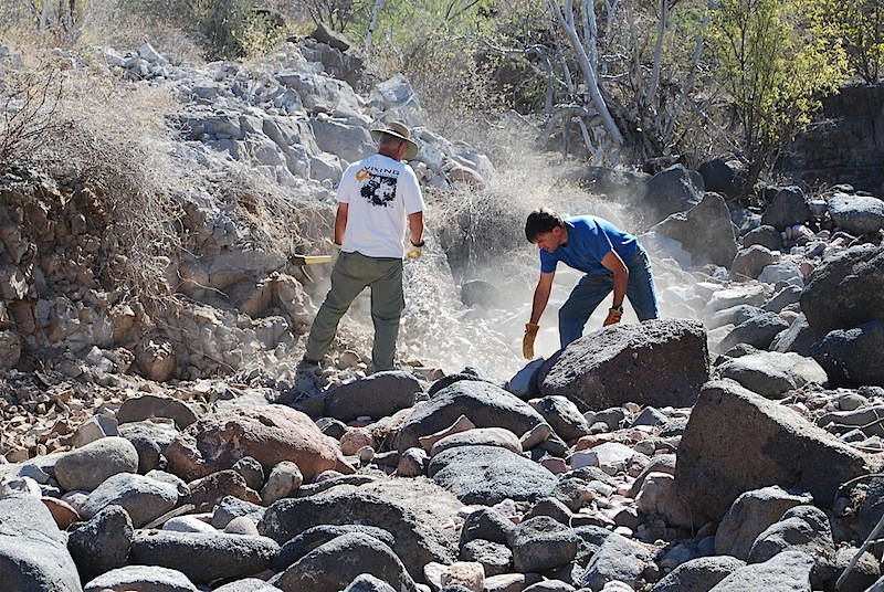
We opened up an abandoned road some years ago (with 4x4) - took us 3 days for 4 miles when it got rough. We all still smile when we talk about it.
One night the pasta water was foaming more than usual. Somebody had thrown a paper towel with dish washing liquid in the pot by accident (he told us
after dinner). It was good pasta.
https://carlosnpainter.smugmug.com/Events/Uno-Baja-Extreme-A...
[Edited on 10-29-2015 by 4x4abc]
Harald Pietschmann
|
|
|
David K
Honored Nomad
Posts: 65562
Registered: 8-30-2002
Location: San Diego County
Member Is Offline
Mood: Have Baja Fever
|
|
Great photos... and you know Pacifico is good beer when the Germans drink it!
|
|
|
bajatrailrider
Ultra Nomad
Posts: 2553
Registered: 1-24-2015
Location: Mexico
Member Is Offline
Mood: Happy
|
|
Warning to all dirt bikes ABC can go where you cant go. You like that line Harald,hope your well.The only problem I have heard of on this route(Dirt
Bikes) going off track,using up your fuel.Problem with most all modern water cooled dirt bikes.Like I have MPGs are only 25/35.So when we go exploring
we start with 3.6 gal tank/two extra gal on each side with belt holding.This does make bike hard to ride,but pour in in as you go.I hope to try this
route also,But for this ride.I will run my air cooled dirt bike,that is in 50/62mpg range. Harold when we going on another Mission?

|
|
|
TMW
Select Nomad
Posts: 10659
Registered: 9-1-2003
Location: Bakersfield, CA
Member Is Offline
|
|
Quote: Originally posted by mjs  | Bikes have been through this year. Cameron Steele did it on the Rip ride. He said they had to do a bit of bushwacking to get through and no 4 wheeled
chase vehicles. I would be interested in an updated track if you go this way.
Have fun,
Mark |
Mark do you have an in with Cameron or know someone that does. I would like either a map or a GPS track of the trail he used in the 2014 Rip to Cabo
from San Ignacio to Mulege. Also their opinion on whether it is possible for a 4x4 to get thru on it. I think I know the trail he took but I'm not
100% sure. I'm mainly interested in the section from El Patrocino to San Estanislao.
|
|
|
David K
Honored Nomad
Posts: 65562
Registered: 8-30-2002
Location: San Diego County
Member Is Offline
Mood: Have Baja Fever
|
|
| Quote: Originally posted by TMW | | Quote: Originally posted by mjs | Bikes have been through this year. Cameron Steele did it on the Rip ride. He said they had to do a bit of bushwacking to get through and no 4 wheeled
chase vehicles. I would be interested in an updated track if you go this way.
Have fun,
Mark |
Mark do you have an in with Cameron or know someone that does. I would like either a map or a GPS track of the trail he used in the 2014 Rip to Cabo
from San Ignacio to Mulege. Also their opinion on whether it is possible for a 4x4 to get thru on it. I think I know the trail he took but I'm not
100% sure. I'm mainly interested in the section from El Patrocino to San Estanislao. |
Tom, ... (check u2u)
|
|
|
leo_jb
Newbie
Posts: 19
Registered: 10-28-2015
Member Is Offline
|
|
Ok, here's a summary of my reading-between-the-lines.
Option 1 should be "relatively" easy.
Option 2 would make us all legends. Hardest of the three options; no one has done it.
Option 3 was done at the beginning of this year by a professional driver (4x4abc) over several days, and included the use of pickaxes and chain saws,
items that we are probably not going to take with us. Significant vehicle damage involved. Also completed by an expert motorcycle rider (Cameron)
sometime this year. We are totally up for an adventure, tough spots, possible gas problems, etc., but have any mere mortals been through?
|
|
|
woody with a view
PITA Nomad
Posts: 15940
Registered: 11-8-2004
Location: Looking at the Coronado Islands
Member Is Offline
Mood: Everchangin'
|
|
considering Cameron had a chase crew and a copter i'd say mere mortals need not apply!.
but i can't wait to read the write-up!
|
|
|
TMW
Select Nomad
Posts: 10659
Registered: 9-1-2003
Location: Bakersfield, CA
Member Is Offline
|
|
I think you should give the NWT a try. I'm willing to meet you in the start area like El Barril or anywhere else near there to make sure you have gas.
I'll also wait a given time frame in case you turn around. If you have a spot you can use it and I know a few people that would be willing to receive
it from you and I can call them to see where you are. I have a satellite phone.
It is 13 miles from the jct at the wash to the ocean. Only near the beginning was it really screwed up from the rains. From the ocean inland at La
Trinidad it is 12 miles to El Gato.
I would also suggest you do a side trip to Rancho Santa Barbara to see what the condition is of the trail to Santa Gertrudis. I can follow you in and
meet you at the wash to top off your tanks.
Baja is no fun until you are lost, out of food and water. When you run out of gas and beer is when things start to get interesting.
|
|
|
woody with a view
PITA Nomad
Posts: 15940
Registered: 11-8-2004
Location: Looking at the Coronado Islands
Member Is Offline
Mood: Everchangin'
|
|
that's a nice offer, Tom!
|
|
|
TMW
Select Nomad
Posts: 10659
Registered: 9-1-2003
Location: Bakersfield, CA
Member Is Offline
|
|
Woody that is a great trail down the coast, so isolated from everything. I've done it twice in my Tacoma and I want to do it again.
If I still had my MC I'd join them, but I hate riding over big rocks. I better stick to a truck.
I'm going to be down that way after the Baja 1000. I have some stuff for Pancho at San Rafael and I thought I'd take a run over and see if anyone has
been on the trail recently and also go to Rancho Santa Barbara, I've never been there.
|
|
|
captain.olives
Newbie
Posts: 24
Registered: 11-13-2009
Location: NorCal
Member Is Offline
|
|
| Quote: Originally posted by TMW | | I'm going to be down that way after the Baja 1000. I have some stuff for Pancho at San Rafael and I thought I'd take a run over and see if anyone has
been on the trail recently and also go to Rancho Santa Barbara, I've never been there. |
TMW, I am one of the riders organizing this years trips. Thanks for you input and offer of help!
I am a relatively experienced Baja rider as will be any of our group that attempts this route. The rest of the group will be sent further west on
easier routes. I really want to try to Santa Barbara to Santa Gertrudis, but breaking trail on a big XR with a 5 gallon tank and giant loop bag would
be silly. Best to try another year when I can bring down the two stroke with no luggage and organize some sort of support.
If anyone is sharing Cameron's NWT tracks from the Rip, we would love to have them if they are willing to share. Send to Leo.
I am most concerned about about time and endurance. We need to do it in a day and all have big tanks and bags which takes much more energy riding.
Keep the info coming! I love Baja, thinking, dreaming, planning and anticipating this years trip. 

[Edited on 10-30-2015 by captain.olives]
|
|
|
leo_jb
Newbie
Posts: 19
Registered: 10-28-2015
Member Is Offline
|
|
I got some tracks from 4x4ABC dated March of this year. These appear to be actual recorded tracks, not converted routes or some such. Is that
correct?
Tom - thanks for the very generous offer. We may very well take you up on it, and will certainly keep you posted via this thread. I also will be
bringing a Delormen Inreach, which allows email via satellite. Having a local email contact would be awesome.
Captain Olives? WTF?
|
|
|
mtgoat666
Platinum Nomad
Posts: 21089
Registered: 9-16-2006
Location: San Diego
Member Is Offline
Mood: Hot n spicy
|
|
Leave no trace?
Or scar an unscarred area?
And off roaders wonder why they all get labeled as destructive, eh?

|
|
|
4x4abc
Ultra Nomad
Posts: 4455
Registered: 4-24-2009
Location: La Paz, BCS
Member Is Offline
Mood: happy - always
|
|
P-nche Jesuits "scared" the area - so it's an established trail/road. Why not use it? The locals do it.
Harald Pietschmann
|
|
|
David K
Honored Nomad
Posts: 65562
Registered: 8-30-2002
Location: San Diego County
Member Is Offline
Mood: Have Baja Fever
|
|
When a "wilderness hiker" has a medical emergency, it is the existing and maintained Jeep Trails (4WD vehicle tracks) that can be a life-saving gift
from the "off-roaders'. The term "off road" also is a misnomer because it really means off-highway. The work seen here and other posts by 4x4abc and
others is keeping open already built roads that have been neglected or washed out by Nature. Perhaps a remote rancher will get to a hospital instead
of sure death thanks to the hard working Nomads? Not all roads are built or maintained by government, sometimes the people must take matters into
their own hands.
When Highway One or other government roads were built, millions of plants and animals were destroyed, yet I hear no complaining of that action???
|
|
|
| Pages:
1
2
3
4 |


