| Pages:
1
2
3 |
geoffff
Senior Nomad

Posts: 721
Registered: 1-15-2009
Member Is Offline
|
|
Speaking of gates in the San Pedro Martir park (and I know this is off topic a bit) but does anyone know offhand if I can drive off the main road,
such as going east from where I have marked "access26" to up to where I have marked "San Pedro Martir view"?

I see on Google Earth there is a nice looking road, but I don't know about rules & gates.
-- Geoff
|
|
|
ehall
Super Nomad
Posts: 1906
Registered: 3-29-2014
Location: Buckeye, Az
Member Is Offline
Mood: It's 5 o'clock somewhere
|
|
Been up there twice. Both times we waited at the gate and they had a pilot car lead us up. The last time was with 2 buses full of kids. We got the
grand tour. Last week laguna hanson had more water in it than I had ever seen. Really pretty.
|
|
|
bajatrailrider
Ultra Nomad
Posts: 2553
Registered: 1-24-2015
Location: Mexico
Member Is Offline
Mood: Happy
|
|
There is a marked,dirt road to your right. Half way up,It leads you to Hiking trail. You must stay on road,They frown at off road travel. There is Old
Moto/Hiking trail. Left side leads you to Mikes Sky Rancho. Or out to Pam/Mikes Place. It was a road over 35 years Ago. Wiped out in 1978 storm. Its
still doable,by expert moto rider,Its not allowed. To come out in the park on Moto. You must return the way you came. The trail would be great to Hike
, Great views. What I cant see , with you guys. Google earth. Its not showing the roads up there. Or the trail ,to Your north of Observatory.
|
|
|
PaulW
Ultra Nomad
Posts: 3113
Registered: 5-21-2013
Member Is Offline
|
|
On the observatory highway there is a sign for the turn to Dark Sky's. Gate was wide open and there is a smaller sign on the gate for Rancho La Joya
[Edited on 2-25-2016 by PaulW]
|
|
|
PaulW
Ultra Nomad
Posts: 3113
Registered: 5-21-2013
Member Is Offline
|
|
The drill to get access to the observatory is park by the gate and open the radio box and push the talk button talk and ask for the supervisor to open
the gate. Wait to talk until the radio traffic is quiet. After a short time the supervisor will drive up and open the gate and escort you up the hill
to the observatory. He will talk to you in English and tell you about what he knows. We could not go into the observatory because the workmen were
doing an effort that prevented access.
|
|
|
mtgoat666
Platinum Nomad
Posts: 21089
Registered: 9-16-2006
Location: San Diego
Member Is Offline
Mood: Hot n spicy
|
|
Quote: Originally posted by geoffff  | Speaking of gates in the San Pedro Martir park (and I know this is off topic a bit) but does anyone know offhand if I can drive off the main road,
such as going east from where I have marked "access26" to up to where I have marked "San Pedro Martir view"?
I see on Google Earth there is a nice looking road, but I don't know about rules & gates.
-- Geoff |
Thats a hiking trail. Vehicles not permitted. Its an eAsy hike.
|
|
|
geoffff
Senior Nomad
Posts: 721
Registered: 1-15-2009
Member Is Offline
|
|
Thanks! Good to know.
-- Geoff
|
|
|
TMW
Select Nomad
Posts: 10659
Registered: 9-1-2003
Location: Bakersfield, CA
Member Is Offline
|
|
| Quote: Originally posted by David K | You are doing great Tom!
If the gate is locked at the observatory highway, they sure must not seek uninvited guests at their motel or B&B? When I posted it seemed they
closed up business, I got a bit of flak as if I didn't want them open. Quite the opposite, but just trying to be real not wishful.
|
David when someone was coming to their place thay would contact them thru the web site or email or phone. Mike would then leave the gate unlocked. If
they did not know you were coming, sorry no entry.
|
|
|
TMW
Select Nomad
Posts: 10659
Registered: 9-1-2003
Location: Bakersfield, CA
Member Is Offline
|
|
| Quote: Originally posted by bajatrailrider | | Ok Tom I don't see new road. The new road goes from Mikes to (Now I remember) Rancho La Joya. Could you pull up Rancho La Joya. It is west of Pam's
place. If you turned in from Observatory road. You go in few miles, then road to Rt goes to Pam's place. Slight to left Rancho La Joya. Then from
there rancho,you see new road they built. To go up it very hard. Much easier to go down from Mikes. I Think My Nissan 4x4 would make it down. There is
lots of brush,over growth. The turn real tight,I would think in LWB van. Be tuff. I have been up and down,New way. Many times on dirt bike, Even on
dirt bike.Its not for novice rider. Mike that lives at Coyote,said he will. Ride the routes and report back for us. Im reporting from last week.
|
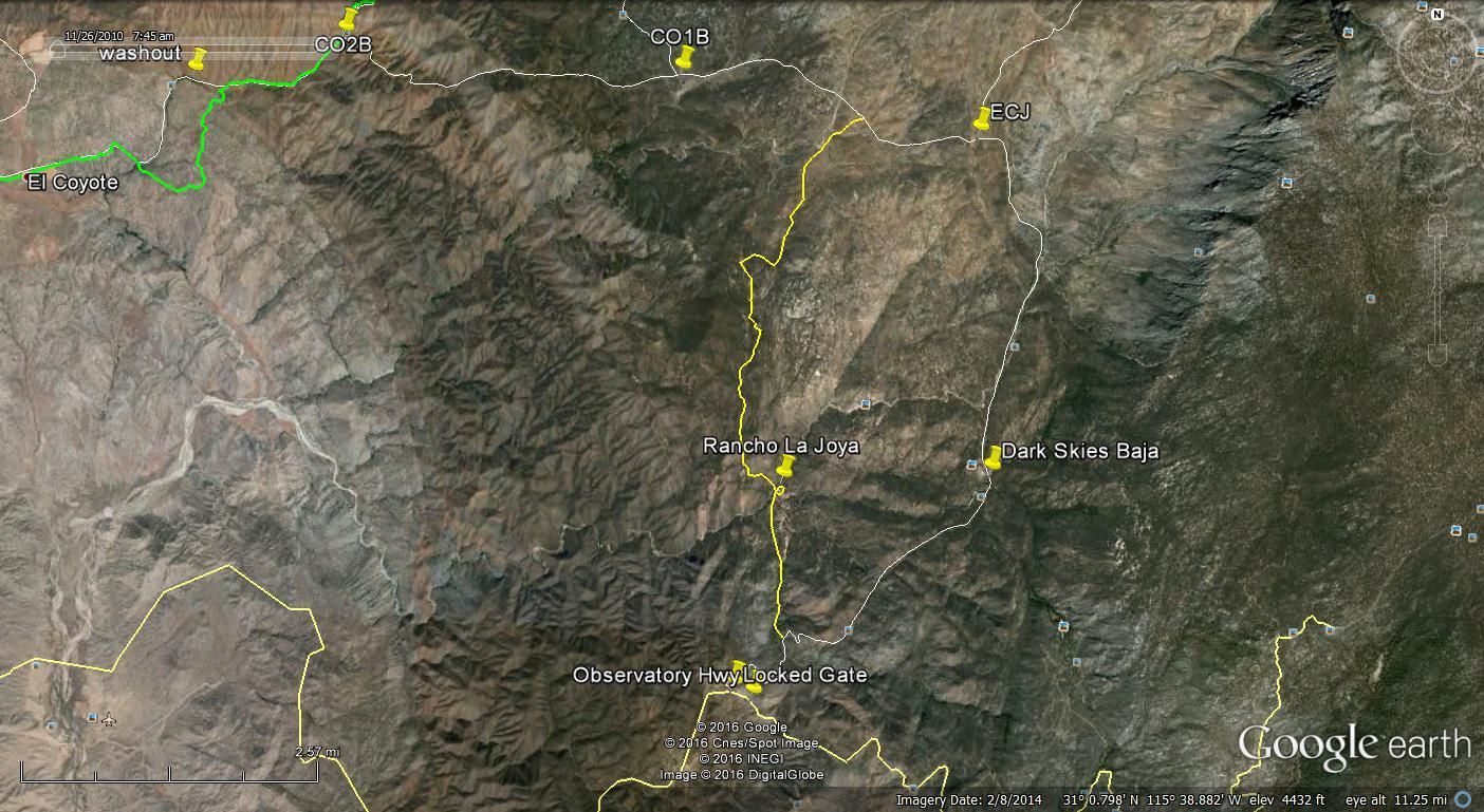
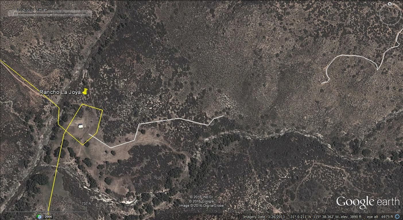
Here is a GE image showing R. La Joya and Dark Skies, Mike and Pam's place. There looks to be a trail from Mike's to the Rancho but when I follow it
close it dead ends unless it is in the wash and covered by trees.
|
|
|
mtgoat666
Platinum Nomad
Posts: 21089
Registered: 9-16-2006
Location: San Diego
Member Is Offline
Mood: Hot n spicy
|
|
Another interesting way to visit the observatory, if you like hiking. From just west of the gate, hike north on trail toward cerro venado blanco, and
at point of your choosing bushwhack east to the crest of the mtns, then follow crest south until you end up at observatory, then walk down road to
your car. This is a difficult hike that involves bush whacking and navigating and a lot of vertical, but its a great area. Recommend hiking in spring
so you get a few snow patches and creeks so can carry less water.
|
|
|
bajatrailrider
Ultra Nomad
Posts: 2553
Registered: 1-24-2015
Location: Mexico
Member Is Offline
Mood: Happy
|
|
TMW Are you saying R is La Joya .Could you circle La Joya. The 4x4 new road into La Joya does have heavy brush both sides. From La Joya going north to
Mike Sky rancho.That should be clearly visible. As it goes up hill.
|
|
|
TMW
Select Nomad
Posts: 10659
Registered: 9-1-2003
Location: Bakersfield, CA
Member Is Offline
|
|
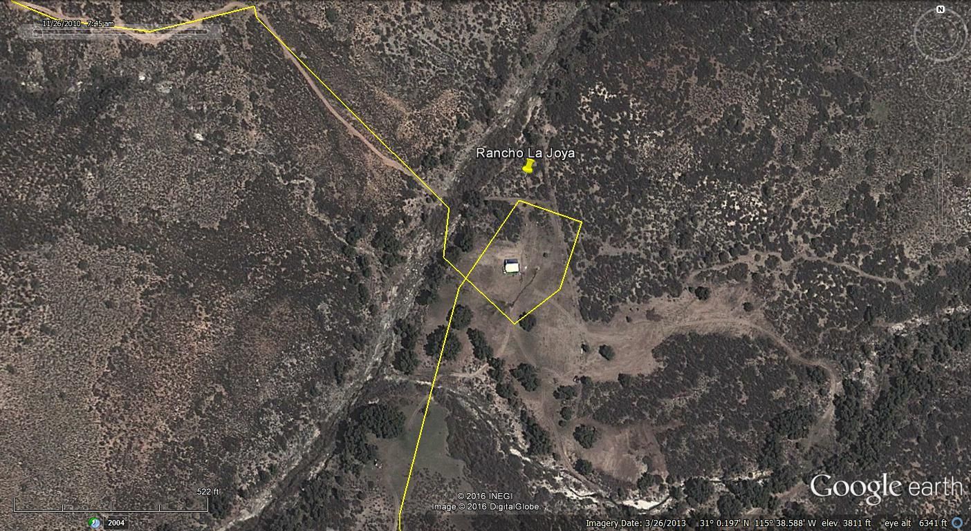
It is the only other facility I saw off the road to Mike and Pam's place.
A closer look.
|
|
|
bajatrailrider
Ultra Nomad
Posts: 2553
Registered: 1-24-2015
Location: Mexico
Member Is Offline
Mood: Happy
|
|
This looks good TW new road.If you up CO1B that looks like best short cut to Joyoa. From ECJ that is the way tried in has jeep. That is no go in LWB
truck . Even on our dirt bikes,Mike from Coyotes.Was trapped for over one hour there. I will be at Melings Mar 11,also April 15 at Coyotes. If anybody
wants to meet up there. Or the best info is from Mike,behind Coyotes. Rancho Joyoa, are good people.Off Road friendly,good camping there,have fishing
pond.
|
|
|
TMW
Select Nomad
Posts: 10659
Registered: 9-1-2003
Location: Bakersfield, CA
Member Is Offline
|
|
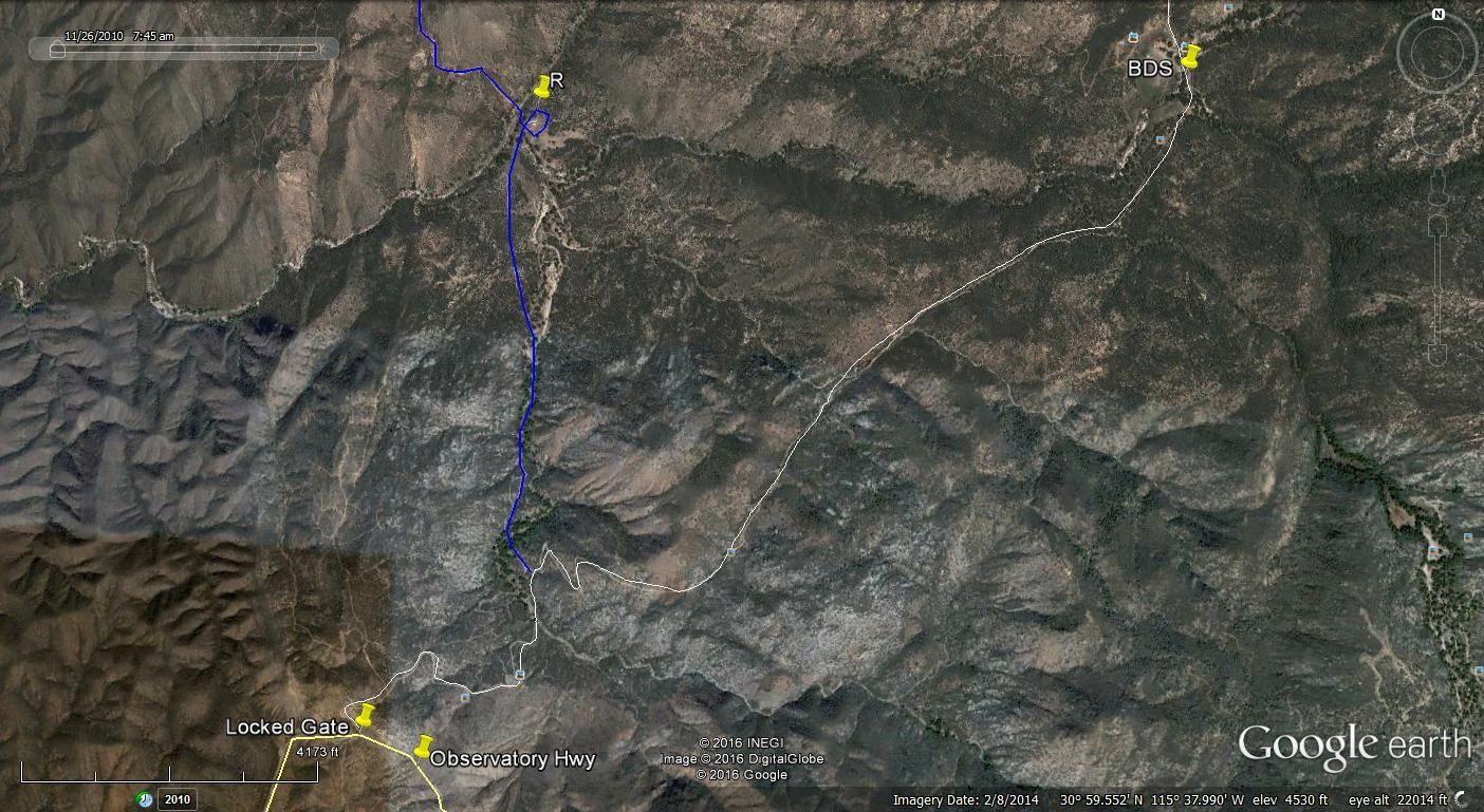
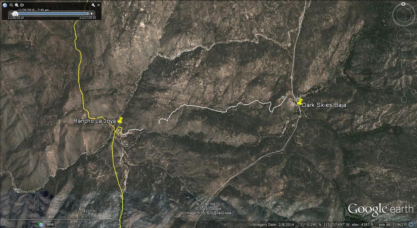
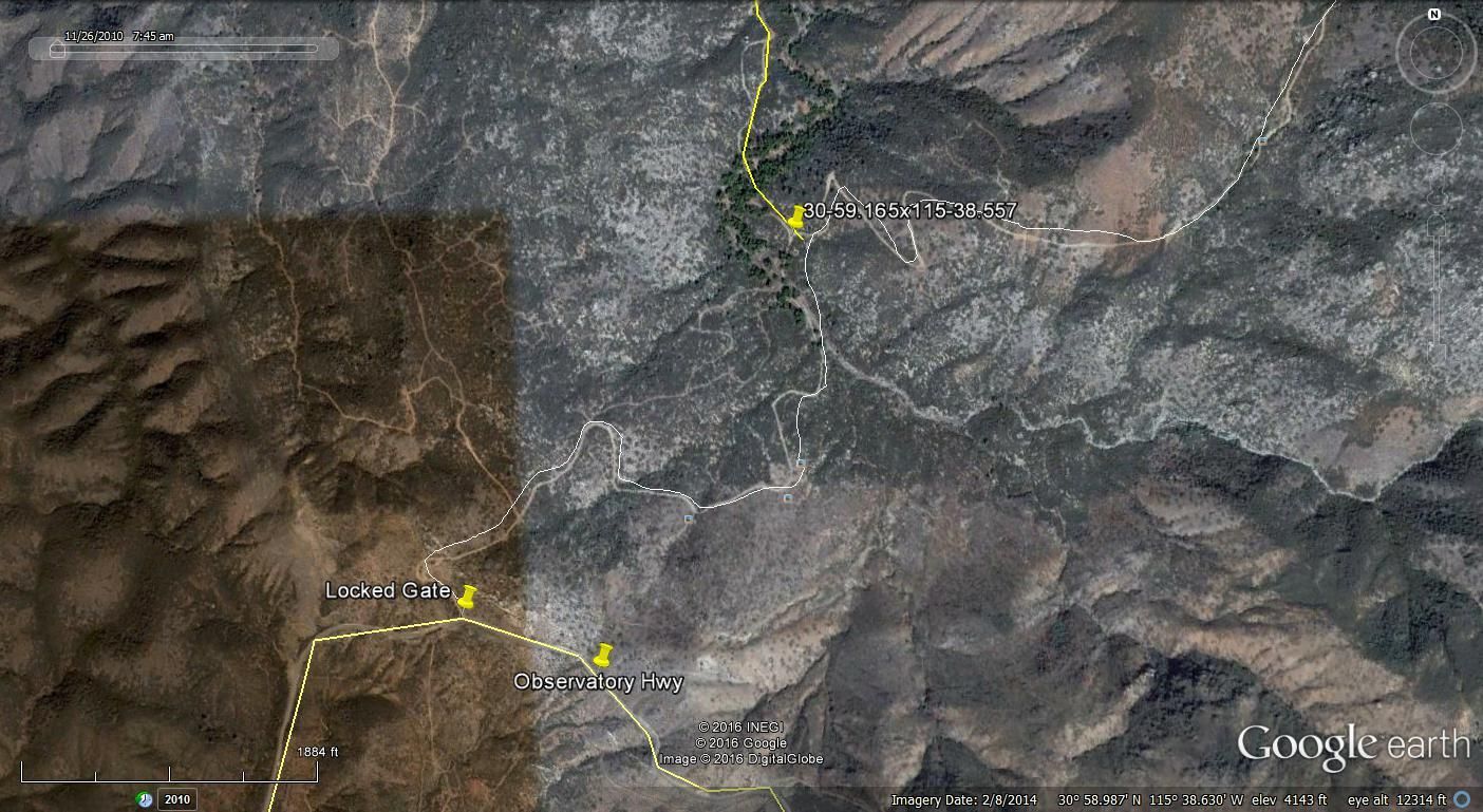
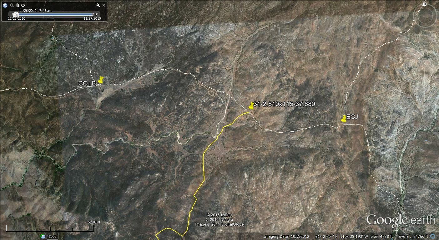
Here are a few more GE images. I traced the trail from Mike and Pam's to Rancho La Joya but I didn't see a complete trail as shown in the first two
images.
A closer look.
Here is where the road to Rancho La Joya starts near the gate at the Park Hwy.
Here is the other end between ECJ and CO1B.
|
|
|
bajatrailrider
Ultra Nomad
Posts: 2553
Registered: 1-24-2015
Location: Mexico
Member Is Offline
Mood: Happy
|
|
Picture number two,is nothing more then foot trail.From Joya to Pam's place.
|
|
|
David K
Honored Nomad
Posts: 65562
Registered: 8-30-2002
Location: San Diego County
Member Is Offline
Mood: Have Baja Fever
|
|
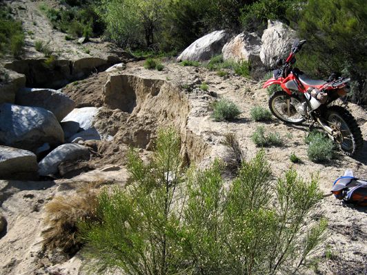
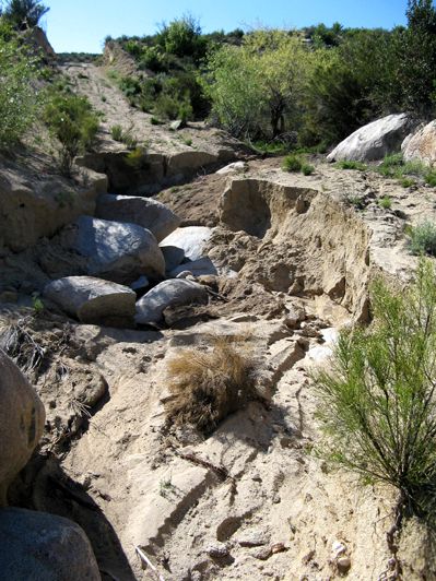
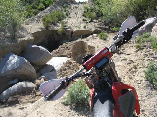
Photos from bajatrailrider
Larry sent me these three photos to share:
|
|
|
ehall
Super Nomad
Posts: 1906
Registered: 3-29-2014
Location: Buckeye, Az
Member Is Offline
Mood: It's 5 o'clock somewhere
|
|
Looks fun. I would give it a try.
|
|
|
bajatrailrider
Ultra Nomad
Posts: 2553
Registered: 1-24-2015
Location: Mexico
Member Is Offline
Mood: Happy
|
|
Thank you for posting for me David.This is one of the washouts.It was sent to me from Mike that lives at Coyote.He will send more pictures of the rest
of washouts. I would be willing to meet up Coyotes,and Show the trails I know there.
|
|
|
bajatrailrider
Ultra Nomad
Posts: 2553
Registered: 1-24-2015
Location: Mexico
Member Is Offline
Mood: Happy
|
|
Just got report from Mike,some Baja Nomads.In jeeps came in from Mikes to Coyote.
|
|
|
PaulW
Ultra Nomad
Posts: 3113
Registered: 5-21-2013
Member Is Offline
|
|
New route Mikes to Coyote Driven 3/2/16
New route Mikes to Coyote Driven 3/2/16
On the GPS screen shot image
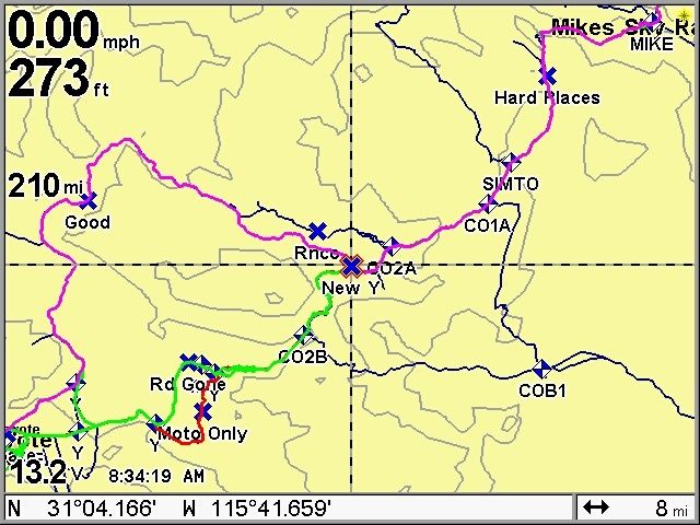 I left TWs WPs on my screen shot and attached tracks. I left TWs WPs on my screen shot and attached tracks.
The keep right when road leaving Mikes at the bottom of the first downhill. Then find several difficult places after that, IMO, a rig needs 33 tires
to pass over and around the large rocks. Then traveling on arrive at the Simpson ranch turnoff. Based on input from Mike at Coyote he said one can
drive to the ranch but the road after the ranch is gone and there is no go around the river washout. ( WP SIMTO).
At TWs WP CO2A do not turn W (RT) as the road west leads to a ranch and locked fence gates.
Proceed to WP New Y and turn right and follow the road that Coyote made to bypass the traditional roads that are now washed out. The road is pretty
easy and is freshly maintained and will work for an SUV. It goes to Coyote thru the horse pasture at a fence gate. Mike has made new colorful signs to
give us good directions.
The traditional roads are twofold. The washed out one with pictures that David posted for Larry on this thread were taken by Mike. (Not the Sky ranch
Mike but the Coyote Mike who lives at Coyote). We had a long discussion with Mike and he confirmed that road is not likely to be repaired any time
soon. He said the other road I labeled Moto Only may be possible for a moto, but not a Jeep due to the bad condition after the 5 days of rain.
The attached .USR file can be loaded by the reader into Google earth and from there one can pick off coordinates as desired. The GPX file I made is
to big so the reader will have to convert the .USR file. FYI, my GPS file also shows the track to the PMEX at Valley Trinidad, the track from Coyote
to the paved road, to Rancho Meling, and to part of the observatory road.
Attachment: USR New M2C.usr (104kB)
This file has been downloaded 344 times
|
|
|
| Pages:
1
2
3 |


