| Pages:
1
2 |
StuckSucks
Super Nomad

Posts: 2376
Registered: 10-17-2013
Location: Pacific Plate
Member Is Offline
|
|
Here's a photo sphere I took last weekend (using the bottom portion of David's map as reference) - east of El Carrizo, at the west end of the fence
line. You can see the straight road/fence line in the photo sphere. AKA San Felipe 250 RM112+.
https://goo.gl/maps/uZBuvxWYNxB2
|
|
|
PaulW
Ultra Nomad
Posts: 3113
Registered: 5-21-2013
Member Is Offline
|
|
Feb 2009 no locked gates on the way to Parral. Corrals opened the unlocked gates
|
|
|
David K
Honored Nomad
Posts: 65562
Registered: 8-30-2002
Location: San Diego County
Member Is Offline
Mood: Have Baja Fever
|
|
Was the road built back to the old ranch house or still ended at the edge of the arroyo just beyond the drive-thru corral?
|
|
|
PaulW
Ultra Nomad
Posts: 3113
Registered: 5-21-2013
Member Is Offline
|
|
Did not make it to the ranch house. The bushes were to thick
Turned around at 30.50194, -115.10815 which a little past the corral and still a couple of miles from the rancho. Did not get as far as the arroyo.
I forgot to ask where the locked gate was.
|
|
|
Barry A.
Select Nomad
Posts: 10007
Registered: 11-30-2003
Location: Redding, Northern CA
Member Is Offline
Mood: optimistic
|
|
Most of the time I tried to get to El Parral Rancho I encountered locked gates at the corral at the intersection of Parral Wash and the cross-over
road to Berrendo Wash. We made efforts to get around it, but to hard to do because of large boulders. This locked gate was about 5 miles from the
actual El Parral Rancho, as I recall.
|
|
|
David K
Honored Nomad
Posts: 65562
Registered: 8-30-2002
Location: San Diego County
Member Is Offline
Mood: Have Baja Fever
|
|
Where Barry said, Paul.
|
|
|
PaulW
Ultra Nomad
Posts: 3113
Registered: 5-21-2013
Member Is Offline
|
|
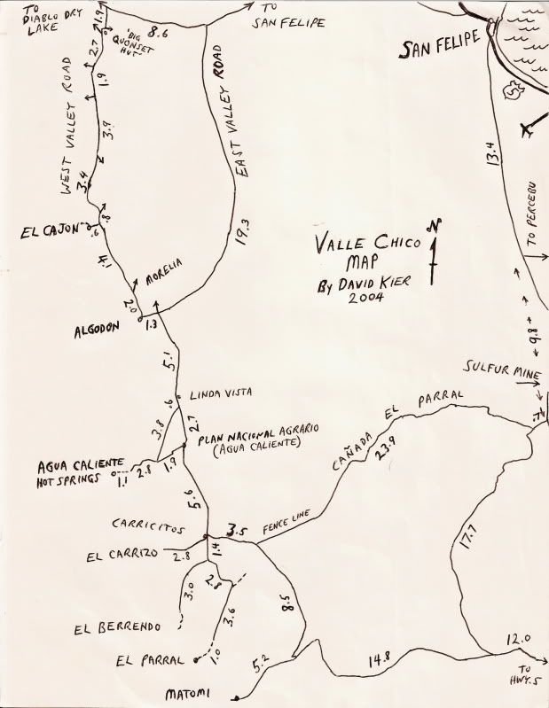
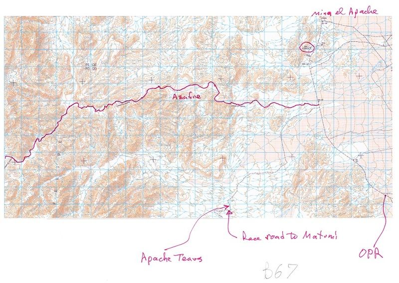
So Back to Arroyo Azufre =Parral = Crazy Horse & the latest = Indian & Apache, and is shown on Davids hand drawn map 23.9 miles. The INEGI
Topos do not show roads or trails in the arroyos.
I suppose another name Agua Caliente is shown on Davids other map is actually shown as Arroyo Huatamote on IGENI map H11B57. I think the drainage
Agua Caliente is a feeder to one of the Parral drainages and never gets to one of the coast side arroyos?
In the picture below I drew the Arroyo Azufre track and labeled the race road that goes to Matomi. I also noted where the Obsidian tear drops are
found cat the place we call Apache Tears I noted the location of Mina El Apache which we all have called the Sulpher mine for at least 20 years.
The INEGI topo definitely shows the arroyo as Parral.
|
|
|
Barry A.
Select Nomad
Posts: 10007
Registered: 11-30-2003
Location: Redding, Northern CA
Member Is Offline
Mood: optimistic
|
|
I have never been on the road that Paul shows the "Apache tears" notation on-------but I always wanted to----just never got around to it.
As for calling the mine the "sulfur mine for at least 20 years"------we called it the "sulfur mine" back in the early '60's as that is what it looked
like with all the yellow sulfur around the diggings-----this was back when the road that goes past the sulfur mine was the ONLY road to PuerteCitos,
way before the pavement and relocation of the "new" road from San Felipe much closer to the coast. Back then San Felipe was a tiny dirt town, and a
lot of fun to party in with the locals. My first visit and camping in San Felipe was in the early '50's with my Aunt (an intrepid explorer of Baja).
|
|
|
David K
Honored Nomad
Posts: 65562
Registered: 8-30-2002
Location: San Diego County
Member Is Offline
Mood: Have Baja Fever
|
|
Yes indeed Paul!
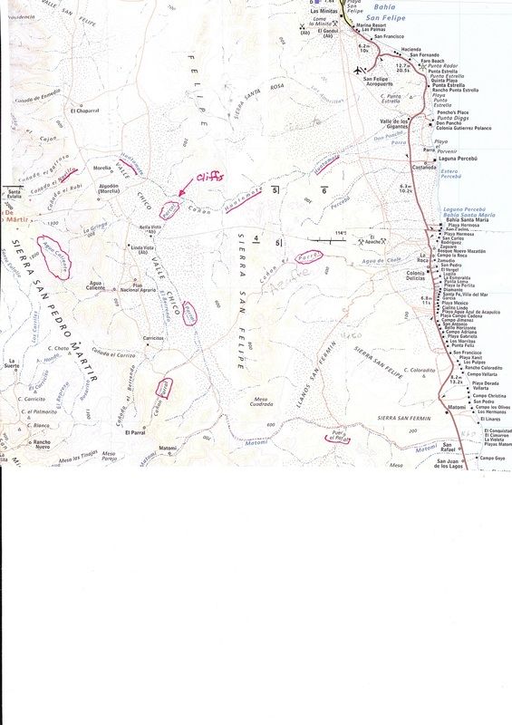
The topo map calls "Azufre Wash" Cañada el Parral. The name Azufre Wash may have come from Sal Fish after I wrote to him about possibly using the
ancient road south of the sulfur mine about 35 years ago for his race.
The topo is also the first time anyone from the day, heard of the sulfur mine having the name El Apache!
Bruce Barber comes along and gives many of these places his own names in the 1990s, "Crazy Horse" for example.
I am 'guilty' of naming the barrier island beach that runs for 4 miles south from Percebu, "Shell Island" in 1978, and the rough grade near Mission
Santa Maria "The Widowmaker" in 1999. Both names seemed appropriate and unique to any other place in Baja (there is already a 'Shell Beach' in Baja,
but it is not an island, either).
The naming the wash out to Punta Diggs from the Sierra San Pedro Martir as Arroyo Agua Caliente was not my creation... it came from existing maps of
the time (1970s)... We had no topo maps to get names from then.
|
|
|
PaulW
Ultra Nomad
Posts: 3113
Registered: 5-21-2013
Member Is Offline
|
|
Mina El Apache was unknown to me until I looked on the topo recently.
Yes, Agua Caliente is a major topo labeled Arroyo or canyon that comes form San Pedro Matier. Of course its the one that has the trail way up high in
the Matier.
My unfinished blog that gets me up to date on the many canyons just takes more time than I have. Takes to much time to dig out the topo to show you
now.
And I do not have a problem with the local names. I just document them so people can find them on the maps. The Azufre name is a puzzle when Parral
is the dominant labeled drainage. Maybe the name Apache was unknown or not liked? I am OK with Azufre - good choice.
|
|
|
David K
Honored Nomad
Posts: 65562
Registered: 8-30-2002
Location: San Diego County
Member Is Offline
Mood: Have Baja Fever
|
|
Well Azufre means Sulfur... but it was Sal or one of the Score folks who named Parral Pass "Azufre Wash" as it begins a couple miles from the "Azufre"
mine.
Apache Tears (obsidian nuggets) is no connection with El Apache Sulfur Mine, however. There are apache tears along the Parral road just a mile west
of the old Puertecitos road, too.
The Agua Caliente arroyo connects with others in Valle Chico and is renamed Huatamote out to Punta Diggs. When I drew my first San Felipe South maps
in the 1970s, I was not aware of the name Huatamote.
|
|
|
PaulW
Ultra Nomad
Posts: 3113
Registered: 5-21-2013
Member Is Offline
|
|
Bruce Barber in several of his web articles said he created the name "Huatamote Trail" which per his varying descriptions could be either Chanate or
Huatamote?
And as you know before Nora (1997) there was a passable track into the outlet of the valley watershed as shown on the topos and the Almanac. Since
then we have had to use a side canyon which is part of the extensive Parral drainage system to get to the valley.
Anyway here it a spliced image of the area with Parral and Huatamote highlighted
|
|
|
David K
Honored Nomad
Posts: 65562
Registered: 8-30-2002
Location: San Diego County
Member Is Offline
Mood: Have Baja Fever
|
|
Yep, and interesting that the name "Parral" (Vineyard in English) is used so close together in unconnected canyons/ arroyos.
Since the ancient road from the sulfur mine went right to the Parral canyon, north of Matomí, the ravine across the coastal mountain (Cañada el
Parral) the road used simply got the name of the destination?
Up in Parral Canyon (where the abandoned ranch is) are wild grapes.
|
|
|
| Pages:
1
2 |


