| Pages:
1
2
3 |
4x4abc
Ultra Nomad

Posts: 4455
Registered: 4-24-2009
Location: La Paz, BCS
Member Is Offline
Mood: happy - always
|
|
Quote: Originally posted by kevin_in_idaho  | | I keep wondering when there will be an updated version of the inReach as it's quite outdated? I would think that Garmin is/would be working on this
as it wouldn't take much to make it a bit more "modern". |
I am so hoping that Garmin will clean up that mess
one of the reason I bought the DeLorme in the first place - Garmin support
I began my GPS world with DeLorme 100 years ago
it was painful and frustrating
then I moved on to Garmin and have been very happy ever since
it was almost as good as moving from Windows to Mac
I have additionally used sat phones (with the same painful learning process of moving from bad to good) for almost 20 years. saved my ass a couple of
times.
However, SPOT and InReach deliver something a sat phone can't - 24/7 SOS service. With pros knowing how to manage your emergency. It won't help you
much if the only person you can reach on your sat phone is your mother in law in New York (or Munich for that matter), trying to tell her you need a
helicopter to that one particular canyon in Baja.
"Baja?" she asked.
[Edited on 1-3-2017 by 4x4abc]
Harald Pietschmann
|
|
|
willardguy
Elite Nomad
Posts: 6451
Registered: 9-19-2009
Member Is Offline
|
|
| Quote: Originally posted by TMW | It depends on what you mean by instant. Instant help only happens on TV not in the real world.
Any SOS signal requires someone to channel it to an emergency center or if it's automatically sent to an emergency center someone in the emergency
center will need to determine who to contact to get help to you. If you are in the middle of nowhere it could be hours if not days for help to arrive.
|
so you could give the emergency center the contact information of a nomad (lets say someone thats always on) that could text you (assuming you have
whichever unit has the text feature), post your location here and maybe the nearest nomad could help out?
|
|
|
4x4abc
Ultra Nomad
Posts: 4455
Registered: 4-24-2009
Location: La Paz, BCS
Member Is Offline
Mood: happy - always
|
|
| Quote: Originally posted by willardguy |
so you could give the emergency center the contact information of a nomad (lets say someone thats always on) that could text you (assuming you have
whichever unit has the text feature), post your location here and maybe the nearest nomad could help out? |
you might be on to something good.
Help from the knowledgeable Nomad community.
I like it!
Harald Pietschmann
|
|
|
TMW
Select Nomad
Posts: 10659
Registered: 9-1-2003
Location: Bakersfield, CA
Member Is Offline
|
|
For Spot SOS you give them two peoples name and contact info in case more info is needed by the emergency center.
In case of help on Spot you list the people that will get the signal. For me there are a couple of people on my list and I've told my wife to contact
them so they can coordinate any help effort.
[Edited on 1-3-2017 by TMW]
|
|
|
willardguy
Elite Nomad
Posts: 6451
Registered: 9-19-2009
Member Is Offline
|
|
| Quote: Originally posted by TMW | For Spot SOS you give them two peoples name and contact info in case more info is needed by the emergency center.
In case of help on Spot you list the people that will get the signal. For me there are a couple of people on my list and I've told my wife to contact
them so they can coordinate any help effort.
[Edited on 1-3-2017 by TMW] |
so with SOS who typically would you choose to contact? (in baja)
|
|
|
TMW
Select Nomad
Posts: 10659
Registered: 9-1-2003
Location: Bakersfield, CA
Member Is Offline
|
|
The contact info for SOS should be someone who knows your medical history for example. It's not for the extraction itself but in case the responders
need further info maybe for medical issues.
|
|
|
mtgoat666
Platinum Nomad
Posts: 20875
Registered: 9-16-2006
Location: San Diego
Member Is Offline
Mood: Hot n spicy
|
|
Garmin is rolling out several new models that combine the typical garmin hardware with irridium/inreach communication capability. Inreach se+ and
explorer+
Should be available by march 2017
Woke!
Hands off!
“Por el bien de todos, primero los pobres.”
“...ask not what your country can do for you – ask what you can do for your country.” “My fellow citizens of the world: ask not what America
will do for you, but what together we can do for the freedom of man.”
Pronoun: the royal we
|
|
|
David K
Honored Nomad
Posts: 65510
Registered: 8-30-2002
Location: San Diego County
Member Is Offline
Mood: Have Baja Fever
|
|
Tom, to me, the inReach topo maps are nice...
Punta Final area from my explorations last week:
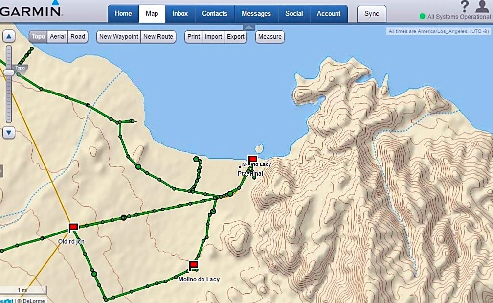
My track (from the top down) is Campo Beluga, El Sacrificio, beach, Punta Final, Molino de Lacy, then from the old road jcn. out to Hwy. 5, south side
of Arroyo Santa Maria bridge.
|
|
|
4x4abc
Ultra Nomad
Posts: 4455
Registered: 4-24-2009
Location: La Paz, BCS
Member Is Offline
Mood: happy - always
|
|
the topo map image shows up where? On your phone? On your computer?
And the settings on your InReach were what?
Harald Pietschmann
|
|
|
David K
Honored Nomad
Posts: 65510
Registered: 8-30-2002
Location: San Diego County
Member Is Offline
Mood: Have Baja Fever
|
|
| Quote: Originally posted by 4x4abc | the topo map image shows up where? On your phone? On your computer?
And the settings on your InReach were what?
|
On my computer, factory settings:
Send Interval: 10 min
Log Interval: 1 min
Extended Tracking: Off
Prompt for MapShare: On
|
|
|
JZ
Select Nomad
Posts: 14466
Registered: 10-3-2003
Member Is Online
|
|
For maps. MotionX on your phone/tablet. Much better. I've had 3-4 Garmin GPSs and the user interface / screen on them is absolute garbage compared
to the phone based apps.
Only value of the InReach is for the messaging, iyam.
[Edited on 1-4-2017 by JZ]
|
|
|
David K
Honored Nomad
Posts: 65510
Registered: 8-30-2002
Location: San Diego County
Member Is Offline
Mood: Have Baja Fever
|
|
Yes, the two way texting feature is terrific. Sadly, there isn't an easy menu for who gets the texts or emails on how to see the track. It is new to
me to use and this past week's trip was a learning one. I had no idea what my friends were seeing or why they couldn't follow me. I still need to look
at the email alerts and how to click onto the moving track.
Edit: Some had a hard time knowing what to click, but others didn't. The emails do come from Garmin and go to your junk folder until you accept it as
known.
[Edited on 1-4-2017 by David K]
|
|
|
PaulW
Ultra Nomad
Posts: 3113
Registered: 5-21-2013
Member Is Offline
|
|
inReach
2 days trying with android phone paired but no transfer of info
Da
The map I get in the states is outstanding. In Baja it is pretty simple and useless in most places I looked.
|
|
|
David K
Honored Nomad
Posts: 65510
Registered: 8-30-2002
Location: San Diego County
Member Is Offline
Mood: Have Baja Fever
|
|
| Quote: Originally posted by PaulW | inReach
2 days trying with android phone paired but no transfer of info
Da
The map I get in the states is outstanding. In Baja it is pretty simple and useless in most places I looked. |
I paired by phone with it, but it was not consistently paired and went through the steps to re-pair the two many times. For most of the trip, the
phone provided a live map of great detail with my speed and heading shown... The map online (when I got home) only has points every minute recorded
with straight lines between (which wasn't bad), but oddly, the last two days it had points every 10 minutes (and that is not a good map of the roads
taken). Why did it change?
|
|
|
bryanmichaelmeyer
Junior Nomad
Posts: 28
Registered: 11-10-2014
Location: Los Osos, CA
Member Is Offline
|
|
inReach in my case has only been used as a check in off the grid and for swell and weather updates. pairing seemed to work for messages but was a
waste of time. just bought a gps for actual mapping.
|
|
|
ehall
Super Nomad
Posts: 1906
Registered: 3-29-2014
Location: Buckeye, Az
Member Is Offline
Mood: It's 5 o'clock somewhere
|
|
The new update seems to have fixed the pairing problem with the droid.
|
|
|
David K
Honored Nomad
Posts: 65510
Registered: 8-30-2002
Location: San Diego County
Member Is Offline
Mood: Have Baja Fever
|
|
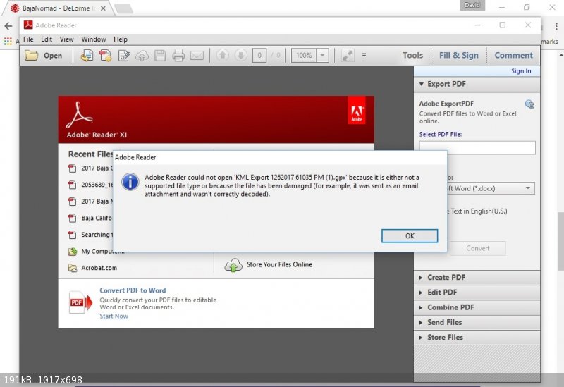
Ed, can you advise me on how to transfer my trip route to Garmin BaseCamp and/or click on the GPX file?
This is what I see when on Map (explore.delorme.com/Map) I click Export (to make a file to send or to put the track on the BaseCamp map):
|
|
|
ehall
Super Nomad
Posts: 1906
Registered: 3-29-2014
Location: Buckeye, Az
Member Is Offline
Mood: It's 5 o'clock somewhere
|
|
http://avoidingchores.com/how-to-export-the-track-log-from-y...
I have never tried it. Basecamp would probably want it in gpx format. Google earth in kml
|
|
|
ehall
Super Nomad
Posts: 1906
Registered: 3-29-2014
Location: Buckeye, Az
Member Is Offline
Mood: It's 5 o'clock somewhere
|
|
It works using gpsvisualizer to open it. Good video on the link that shows what to do.
|
|
|
ehall
Super Nomad
Posts: 1906
Registered: 3-29-2014
Location: Buckeye, Az
Member Is Offline
Mood: It's 5 o'clock somewhere
|
|
Import into my collections on basecamp. works fine.
|
|
|
| Pages:
1
2
3 |


