| Pages:
1
2
3 |
DouglasP
Nomad
 
Posts: 322
Registered: 6-23-2018
Member Is Offline
Mood: Goat hunter.
|
|
Quote: Originally posted by John Harper  | Wow, just downloaded the Gaia GPS app, looks killer! Got all the contour lines and trails for free. Looks better than OSM already.
John |
Much easier to work with also, IMHO!
I like beer, better than most people.
|
|
|
John Harper
Super Nomad
   
Posts: 2289
Registered: 3-9-2017
Location: SoCal
Member Is Offline
|
|
Definitely seems that way, very impressive.
John
|
|
|
JZ
Select Nomad
      
Posts: 13797
Registered: 10-3-2003
Member Is Offline
|
|
Pro tip from a mistake I made. Don't use MotionX. That app is just awful in regards to what it takes to get tracks from Google Earth to it. It
can't read kmz files natively and needs to got through 2-3 steps to get them imported.
BCN is my favorite, but Android only. They are working on BCN XE which is iPhone & Android. It's in Beta now, but missing some important
features.
So, if iPhone, go with Gaia. (Although Samsung >>> Apple for phones).
[Edited on 1-25-2019 by JZ]
|
|
|
StuckSucks
Super Nomad
   
Posts: 2369
Registered: 10-17-2013
Location: Pacific Plate
Member Is Offline
|
|
Quote: Originally posted by DouglasP  | Can you give me a quick tutorial on loading satellite maps, please? Also, will it work with Bing or just Google?
I use both Gaia and Back country navigator extensively. I would like to learn this option.
|
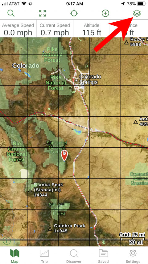
You don't import Google or Bing maps -- a good selection of maps is available from within Gaia.
To add/change/delete maps, start by clicking on the icon in the upper-right:

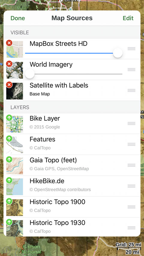
On the resulting page, you can see the maps you have selected at the top (Visible), complete with sliders to adjust opacity. At the bottom part of the
page (Layers) are a selection of maps which you might want to display. Once you have moved maps to the top, you can download portions of those maps
for use off-line.

|
|
|
DouglasP
Nomad
 
Posts: 322
Registered: 6-23-2018
Member Is Offline
Mood: Goat hunter.
|
|
Quote: Originally posted by StuckSucks  | Quote: Originally posted by DouglasP  | Can you give me a quick tutorial on loading satellite maps, please? Also, will it work with Bing or just Google?
I use both Gaia and Back country navigator extensively. I would like to learn this option.
|
You don't import Google or Bing maps -- a good selection of maps is available from within Gaia.
To add/change/delete maps, start by clicking on the icon in the upper-right:

On the resulting page, you can see the maps you have selected at the top (Visible), complete with sliders to adjust opacity. At the bottom part of the
page (Layers) are a selection of maps which you might want to display. Once you have moved maps to the top, you can download portions of those maps
for use off-line.
 |
Thanks! I've used those. Guess I misread your earlier post. I somehow was thinking there was a way to pull a Google sat map in.
I like beer, better than most people.
|
|
|
larryC
Super Nomad
   
Posts: 1499
Registered: 8-11-2008
Location: BoLA
Member Is Offline
|
|
I'm looking at the Gaia on the app store and is the $20 version the one I want for just doing some off road and cross country exploring down here in
Baja? There are several apps and it is a little confusing. There is also an app for hiking, hunting, also a map bundle so not sure what I need.
Off grid, 12-190 watt evergreen solar panels on solar trackers, 2-3648 stacked Outback inverters, 610ah LiFePo4 48v battery bank, FM 60 and MX60
Outback charge controllers, X-240 Outback transformer for 240v from inverters, 6500 watt Kubota diesel generator.
|
|
|
John Harper
Super Nomad
   
Posts: 2289
Registered: 3-9-2017
Location: SoCal
Member Is Offline
|
|
I assume I need be a Premium member to get the "Satellite with Labels" and the "USGS Topo" add on maps?
I see Gaia Topo on the top bar, in gray. I assume that is my default "free" map? Then just scroll to which one I want to use if I buy them? That
simple?
This Gaia is a lot easier to figure out than OSM, so far. Thank you all for this suggestion as an app, looks like it will work great for me.
LarryC - Just download the free one (you can upgrade later) and check it out. It shows topo features in Baja, I checked out the road to Mike's and
it was quite accurate and detailed. Mike's was not identified (maybe if I waited for better resolution?) on the map, but it was easy to discern where
it was, surprisingly accurate IMO. Gonna play with it this weekend, I've already looked at some familiar Sierra spots.
John
[Edited on 1-25-2019 by John Harper]
|
|
|
Pacifico
Super Nomad
   
Posts: 1299
Registered: 5-26-2008
Member Is Offline
|
|
Quote: Originally posted by JZ  | Pro tip from a mistake I made. Don't use MotionX. That app is just awful in regards to what it takes to get tracks from Google Earth to it. It
can't read kmz files natively and needs to got through 2-3 steps to get them imported.
BCN is my favorite, but Android only. They are working on BCN XE which is iPhone & Android. It's in Beta now, but missing some important
features.
So, if iPhone, go with Gaia. (Although Samsung >>> Apple for phones).
[Edited on 1-25-2019 by JZ] |
JZ,
Am I understanding this correctly...with Back Country Navigator you can import tracks from Google Earth and it looks like on Gaia you can not?
Thanks for your help on this...Cool topic and great info!
On a side note, I recently bought a Lowrance Carbon GPS for my off-road truck and it sucks compared to my older Lowrance. I'm used to Lowrance because
that is what I have in my boat with the Navionics map. I had the Murdock Nav Baja map and it was awesome and showed dang near every dirt road and
trail. It won't work in my new Gen 3 Lowrance, so I had to buy the Baja map from PCI and it sucks compared to my old maps...Wish I knew about this
sooner!
"Plan your life as if you are going to live forever. Live your life as if you are going to die tomorrow." - Carlos Fiesta
|
|
|
StuckSucks
Super Nomad
   
Posts: 2369
Registered: 10-17-2013
Location: Pacific Plate
Member Is Offline
|
|
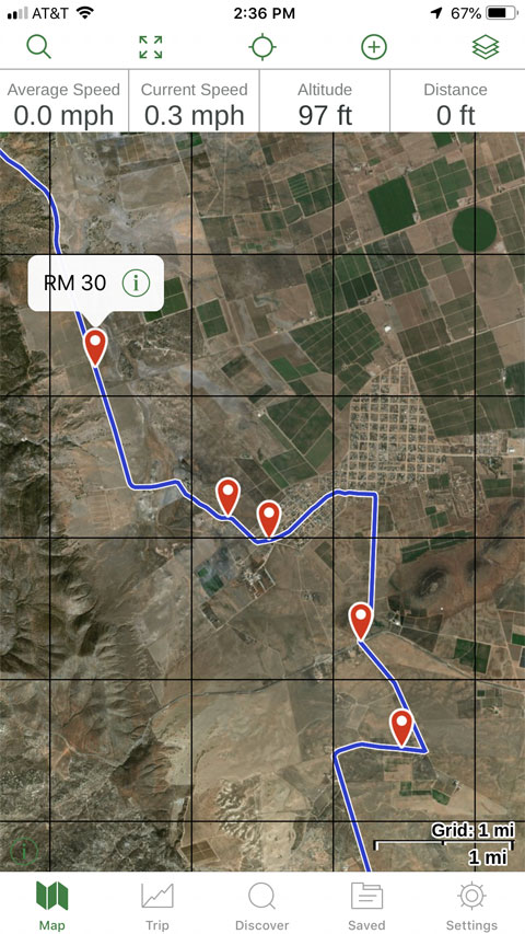
It's very easy to build maps and import them into Gaia as .kml or .gpx files - I do it all the time for our race team, adding chase roads from the
highway to the race course (makes it easy if you have never been on that road before, or if it's dark). This is an example of the '18 Baja 1000 course
near Ojos Negros overlaid on Gaia:

|
|
|
Pacifico
Super Nomad
   
Posts: 1299
Registered: 5-26-2008
Member Is Offline
|
|
Quote: Originally posted by StuckSucks  | It's very easy to build maps and import them into Gaia as .kml or .gpx files - I do it all the time for our race team, adding chase roads from the
highway to the race course (makes it easy if you have never been on that road before, or if it's dark). This is an example of the '18 Baja 1000 course
near Ojos Negros overlaid on Gaia:
 |
So you build it on Google Earth and then convert it?
It looks like I have to subscribe to Gaia...Do you recommend the regular membership or premium?
"Plan your life as if you are going to live forever. Live your life as if you are going to die tomorrow." - Carlos Fiesta
|
|
|
StuckSucks
Super Nomad
   
Posts: 2369
Registered: 10-17-2013
Location: Pacific Plate
Member Is Offline
|
|
Yes, build stuff on Google Maps. I've never used Google Earth to build stuff, but I'd imagine it's the same?
I will import the finished file into both Gaia and my truck's Lowrance GPS -- I think each have advantages/disadvantages, and I like the redundancy.
|
|
|
Bajazly
Super Nomad
   
Posts: 1018
Registered: 6-4-2015
Location: Goodbye Cali and Hello San Felipe
Member Is Offline
Mood: More Relaxed Everyday
|
|
Gotta say Gaia is the stuff. Downloaded it the night before my last Baja trip, messed around with it for a couple hours, imported a GE, KML, file I
have I call Baja Points Of Interest and wow! trails waypoints all with clickable names and descriptions I had put in in GE. I ended up giving them the
$39 for the year(discounted to $35), seemed like it was worth it because you got to do a few extra things which made a difference.
I am using it in the field on an Ipad mini with an external bluetooth antenna for the GPS and I don't think it ever missed a beat. Think it's time to
unwire the Lowrance and free up some dash space.
Pacifico, you can do all the work on GE but the Gaia site seems easier to build routes and add waypoints. GE probably has a better imagery but the
amount of roads I see in Baja on Gaia is pretty impressive. In Gaia you can also see public trails posted by other people and simply click them to
save them to your library of trail.
Believing is religion - Knowing is science
Harald Pietschmann
"Get off the beaten path and memories, friends and new techniques are developed"
Bajazly, August 2019
|
|
|
Pacifico
Super Nomad
   
Posts: 1299
Registered: 5-26-2008
Member Is Offline
|
|
Awesome! Thanks guys!
"Plan your life as if you are going to live forever. Live your life as if you are going to die tomorrow." - Carlos Fiesta
|
|
|
advrider
Super Nomad
   
Posts: 1920
Registered: 10-2-2015
Member Is Offline
|
|
Thanks, now you have me looking at Gaia! I'm already using OSMAND and had Gaia on my phone but never got very far with it.... How do you get it to
show your location? Can you import tracks from your email (that how I do it in OSMAND) ?
|
|
|
JZ
Select Nomad
      
Posts: 13797
Registered: 10-3-2003
Member Is Offline
|
|
Quote: Originally posted by Pacifico  |
So you build it on Google Earth and then convert it?
It looks like I have to subscribe to Gaia...Do you recommend the regular membership or premium? |
You can build from GE or Google Maps. They import directly on Gaia and BCN.
[Edited on 1-26-2019 by JZ]
|
|
|
advrider
Super Nomad
   
Posts: 1920
Registered: 10-2-2015
Member Is Offline
|
|
OK, I've got a little more figured out. I assume you guys(stuck) and others are running the paid version because of the detail you have? I still
haven't figured out importing tracks?
|
|
|
JZ
Select Nomad
      
Posts: 13797
Registered: 10-3-2003
Member Is Offline
|
|
Quote: Originally posted by Bajazly  | | ]In Gaia you can also see public trails posted by other people and simply click them to save them to your library of trail. |
I haven't checked this out yet. Will give it a look.
|
|
|
John Harper
Super Nomad
   
Posts: 2289
Registered: 3-9-2017
Location: SoCal
Member Is Offline
|
|
Do I need to download the premium maps for them to work offline? The Gaia tutorials are very confusing, at least the text instructions. Does the
free Gaia map work offline? It seemed to be working when I put phone on airplane mode and shut off WiFi.
I'm a bit confused about what to do to use the map offline, without any connection to internet.
John
|
|
|
BajaMama
Super Nomad
   
Posts: 1108
Registered: 10-4-2015
Location: Pleasanton/Punta Chivato
Member Is Offline
Mood: Got Baja fever!!
|
|
Avenza Maps in another app that works well. Just purchase the map of the area you want.
|
|
|
JZ
Select Nomad
      
Posts: 13797
Registered: 10-3-2003
Member Is Offline
|
|
Quote: Originally posted by John Harper  | Do I need to download the premium maps for them to work offline? The Gaia tutorials are very confusing, at least the text instructions. Does the
free Gaia map work offline? It seemed to be working when I put phone on airplane mode and shut off WiFi.
I'm a bit confused about what to do to use the map offline, without any connection to internet.
John |
With all these type of apps you need to download the map section you want to use offline.
YouTube in generally better to learn stuff than manuals.
https://youtu.be/xaM39xMqpwU
[Edited on 1-26-2019 by JZ]
|
|
|
| Pages:
1
2
3 |

