| Pages:
1
2 |
geoffff
Senior Nomad

Posts: 721
Registered: 1-15-2009
Member Is Offline
|
|
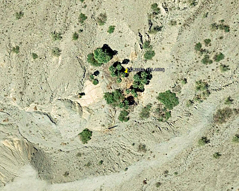
David, I'm pretty sure your little palm grove is here (GPS:32.3383,-115.4833)
-- Geoff
|
|
|
mcnut
Nomad
Posts: 177
Registered: 12-9-2013
Location: Dammeron Valley, UT
Member Is Offline
|
|
I hope folks will use caution around steam vents as it is impossible to know how supportive the area around the vent is. Every few years someone dies
or is gravely burned in Yellowstone by venturing off the boardwalks for a better look and break through the crust.
Also near Bakersfield couple years ago an oilfield worker was investigating steam venting near a well, the crust failed and he was boiled alive.
Please be careful.
Bruce
|
|
|
geoffff
Senior Nomad
Posts: 721
Registered: 1-15-2009
Member Is Offline
|
|
Whoa, I didn't know to consider that. Thank you for the warning!
-- Geoff
|
|
|
bajabuddha
Banned
Posts: 4024
Registered: 4-12-2013
Location: Baja New Mexico
Member Is Offline
Mood: Always cranky unless medicated
|
|
Also to mention the 'sulfur smell' may contain hydrochloric acid that singes your lungs; stay up-wind as well. 
I don't have a BUCKET LIST, but I do have a F***- IT LIST a mile long!
86 - 45*
|
|
|
PaulW
Ultra Nomad
Posts: 3113
Registered: 5-21-2013
Member Is Offline
|
|
Cucapah Fumarole
To use the road Geofff posted look at tthe GPX file Attached.
The road he posted begins on Hwy 5 at Km40, but Km38 is the usual road most take.
Attachment: Cucapah Fumarole.gpx (16kB)
This file has been downloaded 351 times
|
|
|
David K
Honored Nomad
Posts: 65587
Registered: 8-30-2002
Location: San Diego County
Member Is Offline
Mood: Have Baja Fever
|
|
Paul, my machine could not open your gpx. Can you make it a kml(?) ?
|
|
|
geoffff
Senior Nomad
Posts: 721
Registered: 1-15-2009
Member Is Offline
|
|
David, here you go. Also, you should be able to open GPX files in Google Earth by using the File-->Import menu function, or simply by dragging the
GPX file over the Google Earth window after Google Earth has started.
Attachment: Cucapah Fumarole.kml (7kB)
This file has been downloaded 378 times
|
|
|
David K
Honored Nomad
Posts: 65587
Registered: 8-30-2002
Location: San Diego County
Member Is Offline
Mood: Have Baja Fever
|
|
Thanks Geoff. The KML opens right away for me in Google Earth whereas GPX files give me an Adobe Error pop up! If I have a problem, I imagine other
Nomads might as well. Can't drag a file if it won't open.
So, is this road, just south of the BC Hwy. 4/ Mex Hwy. 5 bridge/ junction the best way in?
|
|
|
PaulW
Ultra Nomad
Posts: 3113
Registered: 5-21-2013
Member Is Offline
|
|
==
open gpx files on your GPS
Convert KMZ filed to Kml by downloading the file and change teh kMZ to ZIP and then convert to a KML
[Edited on 4-23-2019 by PaulW]
|
|
|
PaulW
Ultra Nomad
Posts: 3113
Registered: 5-21-2013
Member Is Offline
|
|
Well we have been sharing GPX file for a long time. Did you forget?
A very easy way to view a GPS file is to use Trackmaker. Open the file there and save as a KML or to other GPS formats.
Of course is all you want is a Google earth image KML and KMZ give the same result.
Yes south of the highway to Durango at the big overpass. The Km 40 is a common exit to get to L Salidia.
Quote: Originally posted by David K  | Thanks Geoff. The KML opens right away for me in Google Earth whereas GPX files give me an Adobe Error pop up! If I have a problem, I imagine other
Nomads might as well. Can't drag a file if it won't open.
So, is this road, just south of the BC Hwy. 4/ Mex Hwy. 5 bridge/ junction the best way in? |
|
|
|
mtgoat666
Platinum Nomad
Posts: 21152
Registered: 9-16-2006
Location: San Diego
Member Is Offline
Mood: Hot n spicy
|
|
You may be thinking about hydrogen sulfide?
Agree, the gasses are unhealthy.
And the temps can cause bad burns, lots of people have been hurt messing around hot springs, geysers, etc.
people like to get up close to hot vents and pools, but one stumble and they got severe burns....
[Edited on 4-23-2019 by mtgoat666]
Woke!
Hands off!
“Por el bien de todos, primero los pobres.”
“...ask not what your country can do for you – ask what you can do for your country.” “My fellow citizens of the world: ask not what America
will do for you, but what together we can do for the freedom of man.”
Pronoun: the royal we
|
|
|
4x4abc
Ultra Nomad
Posts: 4456
Registered: 4-24-2009
Location: La Paz, BCS
Member Is Offline
Mood: happy - always
|
|
| Quote: Originally posted by David K | Thanks Geoff. The KML opens right away for me in Google Earth whereas GPX files give me an Adobe Error pop up! If I have a problem, I imagine other
Nomads might as well. Can't drag a file if it won't open.
So, is this road, just south of the BC Hwy. 4/ Mex Hwy. 5 bridge/ junction the best way in? |
download file
open Google Earth (unless it is always open like mine)
chose "Open File" from menu
select the downloaded file
voila!
or wolla (saw that on facebook yesterday)
Harald Pietschmann
|
|
|
JZ
Select Nomad
Posts: 14912
Registered: 10-3-2003
Member Is Offline
|
|
We need more posters on here like Geoffff.
Great pics. Shares tracks and stories. Technology savvy.
|
|
|
StuckSucks
Super Nomad
Posts: 2376
Registered: 10-17-2013
Location: Pacific Plate
Member Is Offline
|
|
| Quote: Originally posted by JZ | We need more posters on here like Geoffff.
Great pics. Shares tracks and stories. Technology savvy.
|
YES, totally agree. Love the use of lat/lon digital degrees -- makes it easy to follow along with Google maps (or other), satellite views, etc.
|
|
|
David K
Honored Nomad
Posts: 65587
Registered: 8-30-2002
Location: San Diego County
Member Is Offline
Mood: Have Baja Fever
|
|
Geoff is a real nice person, too. We had the pleasure of his company here on his northbound leg. I really look forward to his annual Baja explorations
shared here.
|
|
|
PaulW
Ultra Nomad
Posts: 3113
Registered: 5-21-2013
Member Is Offline
|
|
Just saying
Does not matter to me, but if you want to plot on the Almanac degrees and minutes are the easiest for me because no conversion is needed.
And you can set Google and Ozi and all the other satellite views for any coordinates you want.
=== ==
| Quote: Originally posted by StuckSucks | | Quote: Originally posted by JZ | We need more posters on here like Geoffff.
Great pics. Shares tracks and stories. Technology savvy.
|
YES, totally agree. Love the use of lat/lon digital degrees -- makes it easy to follow along with Google maps (or other), satellite views, etc.
|
|
|
|
PaulW
Ultra Nomad
Posts: 3113
Registered: 5-21-2013
Member Is Offline
|
|
Yes, this track is the northern track out of three main ways to get to the lake bed from Hwy5. This one is called Lopez Mateos track. The road to
where the turn to the fumarole is should be very drivable. The turn to the north to Fumarole may be sketchy?
Turn off Hwy 5 would be Km38 or 40.
My pic is from a screenshot off my GPS and shows the road and the track north to Fumarole.
====== ==== == =
|
|
|
BajaNomad
|
Thread Moved
1-13-2020 at 03:37 PM |
| Pages:
1
2 |


