| Pages:
1
2
3
4
..
6 |
JZ
Select Nomad

Posts: 14761
Registered: 10-3-2003
Member Is Offline
|
|
Quote: Originally posted by Mulege Canuck  | I drive half way from Mulege towards San Juanico. Nice swimming hole up there. Camp overnight and head back the next day. It is two trips really.
On the way up it is steep and your view is limited to the road in front of you. On the way back the views are incredible. I drive it with a camper
but it is a little sporty with it. Non issue with a taco.
Swimming Hole “Agua de Gringo “
26’ 40.654 N
112’ 20.873 W |
I mapped out the path to your "Agua de Gringo" off of the Guadalupe Mission loop. Lots of ranches up there. Can you get through all the way to the
coast?
Attachment: Rt to Agua de Gringo.kmz (3kB)
This file has been downloaded 278 times
[Edited on 8-27-2019 by JZ]
|
|
|
advrider
Super Nomad
Posts: 1924
Registered: 10-2-2015
Member Is Offline
|
|
That's it, I remember when the door was still there, wasn't there also a refrigerator that some Canadian's had painted flock ya, Baja on it, also
headed south from BOLA?
|
|
|
David K
Honored Nomad
Posts: 65550
Registered: 8-30-2002
Location: San Diego County
Member Is Offline
Mood: Have Baja Fever
|
|
Sorry, that I don't remember.
|
|
|
honda tom
Nomad
Posts: 493
Registered: 8-28-2003
Location: middle calif
Member Is Offline
|
|
door is gone...… now its a tire.
|
|
|
AKgringo
Elite Nomad
Posts: 6345
Registered: 9-20-2014
Location: Anchorage, AK (no mas!)
Member Is Offline
Mood: Retireded
|
|
The surfboard probably still marks the turn off to Las Animas. That is a fun side trip, and a few good campsites in there!
If you are not living on the edge, you are taking up too much space!
"Could do better if he tried!" Report card comments from most of my grade school teachers. Sadly, still true!
|
|
|
honda tom
Nomad
Posts: 493
Registered: 8-28-2003
Location: middle calif
Member Is Offline
|
|
if heading to mission san Borja from BOLA hyw…. 4 miles in as road turns south go straight (its by an abandoned rancho with buildings)…. we call
it the start of 22 days trail. You go another 3 miles and 22 days single track goes straight.... you vere SW in trucks.head into Palo Chino and enjoy
yourself! At Hwy 1 give the rancher 50 pesos to open the gate... good dude, shot the chit with him and share a beer.
Go 1/2 mile north on hwy 1 and head out by the ranches... watch for the valley and head to the pacific... this route drops you on the coast a couple
miles north of Santa Rosalito. 2wd will make it. from here San Fran.. GN..or mariscos at New Rosarito.
|
|
|
advrider
Super Nomad
Posts: 1924
Registered: 10-2-2015
Member Is Offline
|
|
Rode that single track last year(22 day) very fun stretch of single track out to the highway... That rancho is all fixed up and doesn't look abandoned
anymore.. I'll have to try the other route to.
|
|
|
larryC
Super Nomad
Posts: 1499
Registered: 8-11-2008
Location: BoLA
Member Is Offline
|
|
| Quote: Originally posted by David K | | Quote: Originally posted by larryC | | The old road from BoLA to San Francisquito, it goes through La Bocana. You turn off of the graded road at about K35 (where there are 2 tires stood up)
south of Bola and go through a couple of ranchos and then at La Bocana you have to navigate a washed out portion and then on south to meet up with the
graded road to San Francisquito at about K80. Fun little out of the way loop. |
As there were no kilometer markers, do set your trip odometer to zero when you leave the pavement in L.A. Bay town (tire shop/ Xitlali market).
Pass Las Flores jailhouse (see it off to the right) at Mile 9.7.
The old road going right, via La Bocana valley, is at Mile 22.1.
I would have to rate this road as 4WD only and very slow/ rough. You will pass by some of the largest cardón cactus in Baja along the way.
If you pass it, the Bahía las Animas road is about 4 miles further.
The old road rejoins the graded road at Mile 56.3 (on the new road). The old road is very difficult to spot, coming in from the right-rear. Only
motorcycle tracks on it. GPS: 28°26.057', -113°10.444'.
This old road was made famous in the 1967 Erle Stanley Gardner book, Off the Beaten Track in Baja. They opened/ repaired the old road in Feb. 1966. It
does not appear on any maps before then.
This 1989 AAA map has both the old and new roads shown:
Note that the ranch showed as "San Pedro" is actually La Bocana. |
There are Kilometer markers now all the way to and probably beyond SF. Animas turn off is also plainly marked. Probably in the last 6 months. The road
is fairly newly graded and all the wash outs and cement vados are repaired. Will wonders never cease.
Off grid, 12-190 watt evergreen solar panels on solar trackers, 2-3648 stacked Outback inverters, 610ah LiFePo4 48v battery bank, FM 60 and MX60
Outback charge controllers, X-240 Outback transformer for 240v from inverters, 6500 watt Kubota diesel generator.
|
|
|
ehall
Super Nomad
Posts: 1906
Registered: 3-29-2014
Location: Buckeye, Az
Member Is Offline
Mood: It's 5 o'clock somewhere
|
|
Great thread. Gave me a new itch for more exploring.
|
|
|
Mulege Canuck
Nomad
Posts: 393
Registered: 11-27-2016
Member Is Offline
|
|
First time, I drove through from Mulege to San Juanico. Not doing that again. I was cutting brush and small trees for a long way! Not to mention
the scenery is not that spectacular down the never ending arroyos. I would not recommend anyone taking a full-size truck camper on that road past the
swimming hole. I cut the brush back every year. I did not have to cut much last trip.
|
|
|
David K
Honored Nomad
Posts: 65550
Registered: 8-30-2002
Location: San Diego County
Member Is Offline
Mood: Have Baja Fever
|
|
Thanks Larry! Wow, now there is a needed update to the guidebook (which has the road detailed with miles, as there were no km. markers in 2017).
A Request:
Please, any Nomad who can: note the kilometer markers at the points along the road.
Larry or ?: Do the numbers continue from the paved road (adding from the sailboat monument, Km. 66) or do they begin at zero and where is Km. 0?
Thank you!
My road log from L.A. Bay to San Francisquito is in this section, scroll down: http://forums.bajanomad.com/viewthread.php?tid=91898
|
|
|
PaulW
Ultra Nomad
Posts: 3113
Registered: 5-21-2013
Member Is Offline
|
|
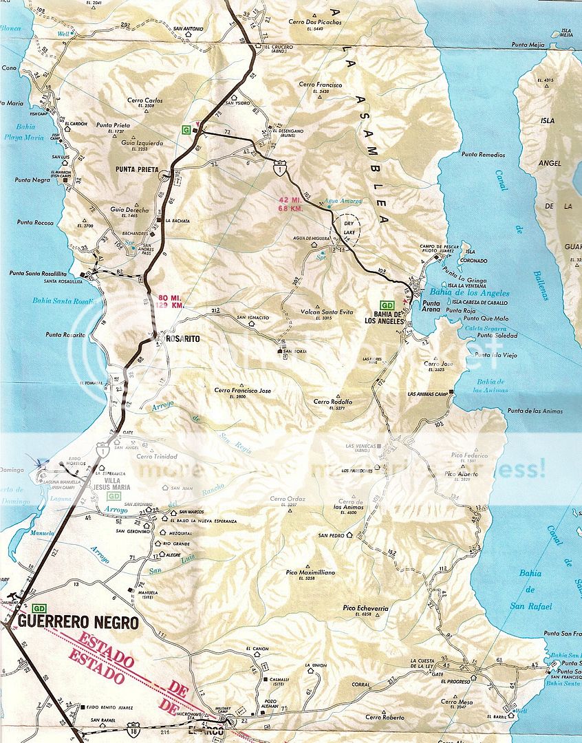
S Borja roads
In the image
S Borja is at 28 44.635, -113 45.24
Junction at K45 on BOLA hwy is at 28 59.175, -113 44.8828
Rosarito at K 52 is at 28 37.875, -114 01.317

|
|
|
Mulege Canuck
Nomad
Posts: 393
Registered: 11-27-2016
Member Is Offline
|
|
| Quote: Originally posted by Mulege Canuck | | First time, I drove through from Mulege to San Juanico. Not doing that again. I was cutting brush and small trees for a long way! Not to mention
the scenery is not that spectacular down the never ending arroyos. I would not recommend anyone taking a full-size truck camper on that road past the
swimming hole. I cut the brush back every year. I did not have to cut much last trip. |
There is a small tienda up there 5 km before the swimming hole. Armando and his family run it. Nice people. Worth a stop.
|
|
|
David K
Honored Nomad
Posts: 65550
Registered: 8-30-2002
Location: San Diego County
Member Is Offline
Mood: Have Baja Fever
|
|
| Quote: Originally posted by honda tom | if heading to mission san Borja from BOLA hyw…. 4 miles in as road turns south go straight (its by an abandoned rancho with buildings)…. we call
it the start of 22 days trail. You go another 3 miles and 22 days single track goes straight.... you vere SW in trucks.head into Palo Chino and enjoy
yourself! At Hwy 1 give the rancher 50 pesos to open the gate... good dude, shot the chit with him and share a beer.
Go 1/2 mile north on hwy 1 and head out by the ranches... watch for the valley and head to the pacific... this route drops you on the coast a couple
miles north of Santa Rosalito. 2wd will make it. from here San Fran.. GN..or mariscos at New Rosarito. |
Palo Chino?
Gate at Hwy. 1?
Can you post a map that shows where these points are so we have an idea of where this road is in relation to the main San Borja roads?
That is great country in there!
|
|
|
PaulW
Ultra Nomad
Posts: 3113
Registered: 5-21-2013
Member Is Offline
|
|
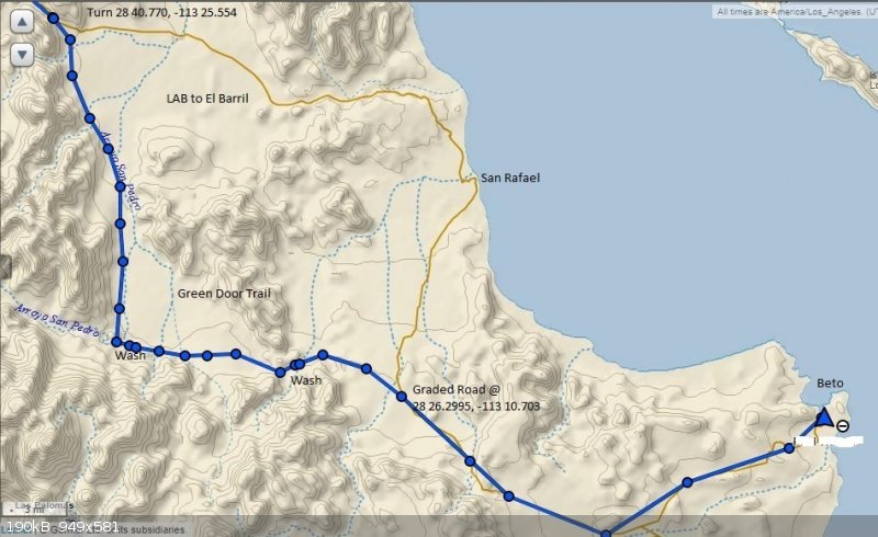
Green door trail
Green Door trail (aka San Pedro trail) From LAB going south the Green door loop crosses the huge wash twice called “Arroyo San Pedro” then back to
the LAB to El Barril road. The wash crossings were difficult and high clearance and 4x4 was needed.
Details: Green door road leaves the LAB/El Barril road at about 28 40.77, -113 25.554 with a right turn. This is where the missing green door used to
be.
Merge the LAB to El Barril road at 28 26.3, 113 10.7.
See the road on the Almanac.
|
|
|
JZ
Select Nomad
Posts: 14761
Registered: 10-3-2003
Member Is Offline
|
|
| Quote: Originally posted by AKgringo | | The surfboard probably still marks the turn off to Las Animas. That is a fun side trip, and a few good campsites in there! |
Never been there. How's the drive in? Can you camp on the beach at Las Animas?
|
|
|
bajatrailrider
Ultra Nomad
Posts: 2551
Registered: 1-24-2015
Location: Mexico
Member Is Offline
Mood: Happy
|
|
| Quote: Originally posted by mtgoat666 | | Quote: Originally posted by JZ | By easy/medium, I mean can be done with a good, stock 4x4 by a driver with a bit of off road experience. No real rock climbing. No road building.
Distance 30 to 60 miles, give or take.
If you don't have 5, just give us 1 or 2 of your favorites.
The best trails in Baja .are not visited by idiot tourest from San Diego. Jajaja
[Edited on 8-25-2019 by JZ] |
The best places in baja are inaccessible by motor vehicle... |
|
|
|
bajatrailrider
Ultra Nomad
Posts: 2551
Registered: 1-24-2015
Location: Mexico
Member Is Offline
Mood: Happy
|
|
| Quote: Originally posted by JZ | | Quote: Originally posted by AKgringo | | The surfboard probably still marks the turn off to Las Animas. That is a fun side trip, and a few good campsites in there! |
Never been there. How's the drive in? Can you camp on the beach at Las Animas?
|
. you want great 4x4 and dirt bike
trails . Just visit me already took David to hot springs I think he liked it
|
|
|
AKgringo
Elite Nomad
Posts: 6345
Registered: 9-20-2014
Location: Anchorage, AK (no mas!)
Member Is Offline
Mood: Retireded
|
|
JZ, I did not spend a lot of time there, but there seemed to be quite a few options for camping. In addition to beach access, there were some decent
sites shaded by trees. If you have a paddle board or kayak, there are some interesting mangrove lagoons as well.
I was in there in December, and DK did his trip report on that road within a week of my visit. The road must have been in much better shape in the
past, because there are several mobile homes and houses built there (all vacant on my trip) that would have required a lot better access than is
current.
Nature has re-aligned the road in a few places, and some of them were soft, but my light weight Kia could have made the trip in 2wd.
If you are not living on the edge, you are taking up too much space!
"Could do better if he tried!" Report card comments from most of my grade school teachers. Sadly, still true!
|
|
|
4x4abc
Ultra Nomad
Posts: 4455
Registered: 4-24-2009
Location: La Paz, BCS
Member Is Offline
Mood: happy - always
|
|
best beach here:
28°49'21.01"N 113°21'52.94"W
Harald Pietschmann
|
|
|
| Pages:
1
2
3
4
..
6 |


