| Pages:
1
2
3
4
5
6 |
4x4abc
Ultra Nomad

Posts: 4456
Registered: 4-24-2009
Location: La Paz, BCS
Member Is Offline
Mood: happy - always
|
|
Quote: Originally posted by Fatboy  | Just got home, and I am downloading your file now.
4x4abc has tons of waypoints, so you should get some good info there.
And of course Kevin and Genevieve have many waypoints for the trail itself. |
Kevin picked a route that is not completely covered by (the other) Kevin's waypoints
Harald Pietschmann
|
|
|
4x4abc
Ultra Nomad
Posts: 4456
Registered: 4-24-2009
Location: La Paz, BCS
Member Is Offline
Mood: happy - always
|
|
| Quote: Originally posted by cupcake | Harald,
I can see the logic in having the waypoints exactly on the trail, so I am changing my waypoints. It is not difficult or time consuming, but I am
limited in the number of free edits I get with the online PDF editors. When I finish, I will send you the PDF sheets and post them here. I will likely
eventually add compass directions as well, but I might do this by hand on the printed maps.
[Edited on 10-21-2024 by cupcake] |
just load the waypoints into your GPS - that's what it was designed for
Harald Pietschmann
|
|
|
4x4abc
Ultra Nomad
Posts: 4456
Registered: 4-24-2009
Location: La Paz, BCS
Member Is Offline
Mood: happy - always
|
|
use Google earth to set your waypoints - much more accurate than the topo sheets
Harald Pietschmann
|
|
|
cupcake
Senior Nomad
Posts: 847
Registered: 4-23-2024
Member Is Offline
|
|
https://filebin.net/fn8b7iovjbgh4hjy
The above link is to the the PDF of my Santa Gertrudis to San Ignacio route, with GPS waypoints moved onto the trail. This link remains active for six
days only.
I have been advised that some of this route is not the original ECR. Harald has sent files to me that contain route variations, which I plan on
incorporating into my map when I can. I imagine if I took a guide / vaquero on this trek, they also might have their own trail variations that they
like to use.
|
|
|
David K
Honored Nomad
Posts: 65581
Registered: 8-30-2002
Location: San Diego County
Member Is Offline
Mood: Have Baja Fever
|
|
| Quote: Originally posted by cupcake | https://filebin.net/fn8b7iovjbgh4hjy
The above link is to the the PDF of my Santa Gertrudis to San Ignacio route, with GPS waypoints moved onto the trail. This link remains active for six
days only.
I have been advised that some of this route is not the original ECR. Harald has sent files to me that contain route variations, which I plan on
incorporating into my map when I can. I imagine if I took a guide / vaquero on this trek, they also might have their own trail variations that they
like to use. |
Here is from today's download, of the south end, from San Ignacio north, first map:
|
|
|
4x4abc
Ultra Nomad
Posts: 4456
Registered: 4-24-2009
Location: La Paz, BCS
Member Is Offline
Mood: happy - always
|
|
| Quote: Originally posted by cupcake | https://filebin.net/fn8b7iovjbgh4hjy
The above link is to the the PDF of my Santa Gertrudis to San Ignacio route, with GPS waypoints moved onto the trail. This link remains active for six
days only.
I have been advised that some of this route is not the original ECR. Harald has sent files to me that contain route variations, which I plan on
incorporating into my map when I can. I imagine if I took a guide / vaquero on this trek, they also might have their own trail variations that they
like to use. |
none of your route is ECR
they are various roads built by the French mining company Boleo around 1910
that's why they are so straight
mining engineers can only think in straight lines
the Boleo roads are in various stages of decay, because they are rarely used by locals
it is very difficult to find true ECR trail sections in areas where Boleo has been active
the original concession Boleo had around Santa Rosalia was 220 sq miles (mining)
it was later expanded to 2317sq miles mainly to produce food for the population of Santa Rosalia
that was an area as far north as San Borja and as far south as San Jose de Gracia
the main hub for the Boleo roads was San Ignacio
during that time Santa Rosalia was the largest urban center in all of Baja
(Settlements in Baja California: 1768-1930
George F. Deasy and Peter Gerhard)
like many large companies during that time, Boleo did not want to leave food supply to local sources - they wanted to be the producer and seller -
workers were forced to only buy in Boleo stores
parts of this old road are wonderfully easy to travel on (like between Santa Gertrudis and Rancho Las Parras/Las Juntas)- much of it in other areas is
in such bad shape that only a local guide (if he even knows what you are talking about) can guide you safely from end to end
large sections are even hard to spot on satellite images - only the fact that they are often dead straight helps you spot something that looks like a
road miles ahead
hikers with a solid Baja background like Genevieve and Kevin have no trouble following the routes independently.
Harald Pietschmann
|
|
|
4x4abc
Ultra Nomad
Posts: 4456
Registered: 4-24-2009
Location: La Paz, BCS
Member Is Offline
Mood: happy - always
|
|
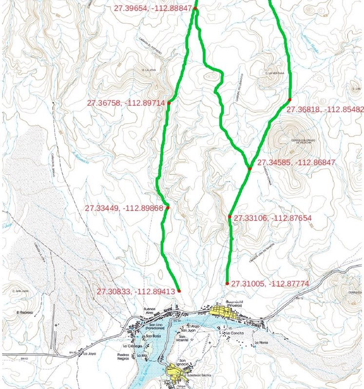
this section does not exist in reality
it shows on the topo maps
but the trails in the area are completely different than on INEGI

here is real life on Google Earth
there is no connection from 27.84454, -113.04296 eastwards to 27.83338, -113.02520
there is the option to follow the Boleo track (grey) east from 27.854486°, -113.041627° - it turns south after 3/4 mile
the southern leg of this track is very difficult to navigate!
alternatively you go south on the newly built highway (white) from that point on

the area in question is found on maps as Buenos Aires - a former Boleo cattle ranch
Kevin and Genevieve have a few spots marked in that area

[Edited on 10-22-2024 by 4x4abc]
Harald Pietschmann
|
|
|
cupcake
Senior Nomad
Posts: 847
Registered: 4-23-2024
Member Is Offline
|
|
| Quote: Originally posted by 4x4abc | | Quote: Originally posted by cupcake | https://filebin.net/fn8b7iovjbgh4hjy
The above link is to the the PDF of my Santa Gertrudis to San Ignacio route, with GPS waypoints moved onto the trail. This link remains active for six
days only.
I have been advised that some of this route is not the original ECR. Harald has sent files to me that contain route variations, which I plan on
incorporating into my map when I can. I imagine if I took a guide / vaquero on this trek, they also might have their own trail variations that they
like to use. |
none of your route is ECR
they are various roads built by the French mining company Boleo around 1910
that's why they are so straight
mining engineers can only think in straight lines
the Boleo roads are in various stages of decay, because they are rarely used by locals
it is very difficult to find true ECR trail sections in areas where Boleo has been active
the original concession Boleo had around Santa Rosalia was 220 sq miles (mining)
it was later expanded to 2317sq miles mainly to produce food for the population of Santa Rosalia
that was an area as far north as San Borja and as far south as San Jose de Gracia
the main hub for the Boleo roads was San Ignacio
during that time Santa Rosalia was the largest urban center in all of Baja
(Settlements in Baja California: 1768-1930
George F. Deasy and Peter Gerhard)
like many large companies during that time, Boleo did not want to leave food supply to local sources - they wanted to be the producer and seller -
workers were forced to only buy in Boleo stores
parts of this old road are wonderfully easy to travel on (like between Santa Gertrudis and Rancho Las Parras/Las Juntas)- much of it in other areas is
in such bad shape that only a local guide (if he even knows what you are talking about) can guide you safely from end to end
large sections are even hard to spot on satellite images - only the fact that they are often dead straight helps you spot something that looks like a
road miles ahead
hikers with a solid Baja background like Genevieve and Kevin have no trouble following the routes independently. |
This is wonderful information, Harald, thanks for taking the time to post it. I am going to be looking at waypoints on Kevin and Genevieve's website.
I marked my 'ECR' route using the information for this section on David's website, which likely has my marked route in the general vicinity of the
ECR. And, David told me I had marked the route well. So, I guess the question is, how determined am I to walk on 'sacred ground', the exact spot where
the original ECR is? Answer: probably not very determined, unless that 'sacred ground' happens to be easier to negotiate than anything else in a
particular place. Still, I would like to walk from Santa Gertrudis to San Ignacio, but this new information you have provided has reinforced my
thoughts of trying to see some cave paintings enroute, out of Santa Martha. Maybe this would entail a walk from Santa Martha to San Francisco, I don't
know.
By the way, somewhere I have read that the Jesuits had a fondness for straight roads, when the terrain would allow for them. Maybe this is something
they had in common with the Boleo engineers?
I have topo maps that cover areas in the U.S., where the last update for the map was so long ago, that trails and even some dirt roads that are marked
on the map are now not to be found. However, the depiction of natural features on these maps, the terrain, seems accurate to me. Topography is easier
for me to read on a topo map, than on Google Earth.
[Edited on 10-22-2024 by cupcake]
|
|
|
cupcake
Senior Nomad
Posts: 847
Registered: 4-23-2024
Member Is Offline
|
|
This reminds me of some trekking I did in India in 2012 and 2013. Hiking on ancient trails, through ancient villages, while road construction was
underway from both ends.
I imagine the villages I hiked through, i.e. Lahaul to Zanskar over the Shingo La, have been markedly changed today.
I would like to find some of that 'roadless village magic' in Baja, if it still exists (as long as I don't get attacked by village dogs).
[Edited on 10-22-2024 by cupcake]
|
|
|
4x4abc
Ultra Nomad
Posts: 4456
Registered: 4-24-2009
Location: La Paz, BCS
Member Is Offline
Mood: happy - always
|
|
there are some nice paintings, El Palmarito, close to Santa Marta.
you will have to hire a guide in Santa Marta for that
27.574369°, -112.963170°
Harald Pietschmann
|
|
|
4x4abc
Ultra Nomad
Posts: 4456
Registered: 4-24-2009
Location: La Paz, BCS
Member Is Offline
Mood: happy - always
|
|
| Quote: Originally posted by cupcake | This reminds me of some trekking I did in India in 2012 and 2013. Hiking on ancient trails, through ancient villages, while road construction was
underway from both ends.
I imagine the villages I hiked through, i.e. Lahaul to Zanskar over the Shingo La, have been markedly changed today.
I would like to find some of that 'roadless village magic' in Baja, if it still exists (as long as I don't get attacked by village dogs).
[Edited on 10-22-2024 by cupcake] |
roadless village magic in Baja?
the closest you get to that is San Ignacio, even though it has a paved road
San Antonio, my favorite
San Jose de Comondu
San Evaristo
Mulege
Santiago
Harald Pietschmann
|
|
|
4x4abc
Ultra Nomad
Posts: 4456
Registered: 4-24-2009
Location: La Paz, BCS
Member Is Offline
Mood: happy - always
|
|
| Quote: Originally posted by cupcake |
By the way, somewhere I have read that the Jesuits had a fondness for straight roads, when the terrain would allow for them. Maybe this is something
they had in common with the Boleo engineers?
[Edited on 10-22-2024 by cupcake] |
The Jesuits created trails that were as direct as possible from point A to point B. If needed, they would go over a mountain rather than around it.
as straight as possible meant if there was a Cardon or a boulder in their path, they would go around it. The original ECR has a very organic feel. It
follows the terrain in a beautiful fashion.
The Boleo tracks, however, go dead straight as much as possible. Created with bulldozers, large vegetation and boulder were just pushed out of the
way. On occasion dynamite was used to blast obstacles out of the way. I have pictures, I can prove it.
also consider this, in areas of Baja where Boleo was not active, ECR is 3 to 4 feet wide. Where Boleo was active, often bulldozing over ECR, the road
they created is between 10 and 30 ft wide. What business were the Jesuits conducting that they needed a dead straight 30 ft wide road? 30ft is the
width of a good airstrip.
satellite images are so accurate by now, they even show the berms of debris left and right of the road left behind by the dozers.
the "ECR" in the image below is 20ft wide, dead straight and has well defined berms
but don't get distracted by this discussion of ECR or not - stick to your plan and follow the route you had envisioned.
I have done it before and it is a serious adventure
because most only talk about
very few actually get their feet on the ground

Harald Pietschmann
|
|
|
4x4abc
Ultra Nomad
Posts: 4456
Registered: 4-24-2009
Location: La Paz, BCS
Member Is Offline
Mood: happy - always
|
|
want a closer view?

Harald Pietschmann
|
|
|
cupcake
Senior Nomad
Posts: 847
Registered: 4-23-2024
Member Is Offline
|
|
Like a cobblestone lane versus asphalt, an uneven but pleasing brick-paved patio versus concrete.
I know what you mean. I am ok with my trek being mostly off-ECR, but I would really like to see some of the original old trail; seeing an original
cuesta would be wonderful.
|
|
|
David K
Honored Nomad
Posts: 65581
Registered: 8-30-2002
Location: San Diego County
Member Is Offline
Mood: Have Baja Fever
|
|
| Quote: Originally posted by cupcake |
Like a cobblestone lane versus asphalt, an uneven but pleasing brick-paved patio versus concrete.
I know what you mean. I am ok with my trek being mostly off-ECR, but I would really like to see some of the original old trail; seeing an original
cuesta would be wonderful. |
Harald is correct about the Jesuit road width of around 1-1.5 meters wide... Read Harry Crosby's details on Jesit road building in the links I posted
for his contributions. Harry studied the Spanish-Jesuit archives to be as precise as possible with his history writing.
When you mention my comments on your placement of the ECR pins, it is not so much from my personal searching (on Google Earth or on the ground) but
from how well your points line up with Kevin's CaminoRealBaja.com points, I think. I just like to complement my Internet friends when they do
hisorical research!
The Boleo roads, made with early 1900s French bull dozrs will be as wide as the blade on one of those, or more. I am sure, there are places where then
went over the top of Jesuit trails.. just as Hwy. 1 and 5 do in some places.
One thing I find amuzing is when there is histaria when motorcycles ride on the old trail but nothing is said when a highway obliterates the old
trail!
Carry on, carry on!
|
|
|
4x4abc
Ultra Nomad
Posts: 4456
Registered: 4-24-2009
Location: La Paz, BCS
Member Is Offline
Mood: happy - always
|
|
| Quote: Originally posted by David K |
One thing I find amuzing is when there is histaria when motorcycles ride on the old trail but nothing is said when a highway obliterates the old
trail!
Carry on, carry on! |
I have studied all Baja tracks in detail
animals, Jesuits, rancher foot trail, Boleo, mining foot trails, ranch roads, early government, Pemex, recent government, MC, MTB, hiking.
Viewed from space, MC trails are the most elegant, most harmonic tracks of them all. Weaving around Cardones and boulders. When they ride on ECR they
sometimes change its layout, but they don't widen or otherwise damage it. Not yet.
Harald Pietschmann
|
|
|
mtgoat666
Platinum Nomad
Posts: 21147
Registered: 9-16-2006
Location: San Diego
Member Is Offline
Mood: Hot n spicy
|
|
| Quote: Originally posted by David K | | Quote: Originally posted by cupcake |
Like a cobblestone lane versus asphalt, an uneven but pleasing brick-paved patio versus concrete.
I know what you mean. I am ok with my trek being mostly off-ECR, but I would really like to see some of the original old trail; seeing an original
cuesta would be wonderful. |
Harald is correct about the Jesuit road width of around 1-1.5 meters wide... Read Harry Crosby's details on Jesit road building in the links I posted
for his contributions. Harry studied the Spanish-Jesuit archives to be as precise as possible with his history writing.
When you mention my comments on your placement of the ECR pins, it is not so much from my personal searching (on Google Earth or on the ground) but
from how well your points line up with Kevin's CaminoRealBaja.com points, I think. I just like to complement my Internet friends when they do
hisorical research!
The Boleo roads, made with early 1900s French bull dozrs will be as wide as the blade on one of those, or more. I am sure, there are places where then
went over the top of Jesuit trails.. just as Hwy. 1 and 5 do in some places.
One thing I find amuzing is when there is histaria when motorcycles ride on the old trail but nothing is said when a highway obliterates the old
trail!
Carry on, carry on! |
Trails of tears! The spanish enslaved the indigenous peoples to build their trails and roads. The spanish diseases wiped out the rest. The entire
culture was destroyed in the name of conversion to christ. I think jesus rolled over in his grave when he saw what the spaniards did in his name!
I suppose MC riders on trails have better intentions than the original trail building bosses who were intent on wiping out a culture and religion, eh?
[Edited on 10-23-2024 by mtgoat666]
Woke!
Hands off!
“Por el bien de todos, primero los pobres.”
“...ask not what your country can do for you – ask what you can do for your country.” “My fellow citizens of the world: ask not what America
will do for you, but what together we can do for the freedom of man.”
Pronoun: the royal we
|
|
|
cupcake
Senior Nomad
Posts: 847
Registered: 4-23-2024
Member Is Offline
|
|
| Quote: Originally posted by David K | | Quote: Originally posted by cupcake |
Like a cobblestone lane versus asphalt, an uneven but pleasing brick-paved patio versus concrete.
I know what you mean. I am ok with my trek being mostly off-ECR, but I would really like to see some of the original old trail; seeing an original
cuesta would be wonderful. |
Harald is correct about the Jesuit road width of around 1-1.5 meters wide... Read Harry Crosby's details on Jesit road building in the links I posted
for his contributions. Harry studied the Spanish-Jesuit archives to be as precise as possible with his history writing.
When you mention my comments on your placement of the ECR pins, it is not so much from my personal searching (on Google Earth or on the ground) but
from how well your points line up with Kevin's CaminoRealBaja.com points, I think. I just like to complement my Internet friends when they do
hisorical research!
The Boleo roads, made with early 1900s French bull dozrs will be as wide as the blade on one of those, or more. I am sure, there are places where then
went over the top of Jesuit trails.. just as Hwy. 1 and 5 do in some places.
One thing I find amuzing is when there is histaria when motorcycles ride on the old trail but nothing is said when a highway obliterates the old
trail!
Carry on, carry on! |
David, Thank you for the kind words. Having recently seen photos of known ECR trail points that Harald sent to me, I must say I was surprised by how
'walkable' the old trail looks in those photos. I realize that the entire path is not like this, but seeing how nice it is in at least some places
makes me want to search out and go to those points.
Regarding motorcycles on the ECR, is it possible that a form of symbiotic relationship exists? Possibly the amount of motorcycle traffic the trail has
seen thus far has reduced overgrowing by the surrounding dessert flora?
|
|
|
cupcake
Senior Nomad
Posts: 847
Registered: 4-23-2024
Member Is Offline
|
|
| Quote: Originally posted by mtgoat666 |
Trails of tears! The spanish enslaved the indigenous peoples to build their trails and roads. The spanish diseases wiped out the rest. The entire
culture was destroyed in the name of conversion to christ. I think jesus rolled over in his grave when he saw what the spaniards did in his name!
I suppose MC riders on trails have better intentions than the original trail building bosses who were intent on wiping out a culture and religion, eh?
[Edited on 10-23-2024 by mtgoat666] |
The Missionaries thought, no they knew, they were helping the Natives. From the benefit of many years of hindsight, we might see things differently
today. I think a distinction can be made from what the Missionaries intended compared to say, precious metal mine operators, who forced Natives to
toil underground (mostly in other parts of New Spain).
Regarding the devastation the Natives suffered from European introduced disease, the only way this would have been avoided is if The Americas had not
been discovered and visited in numbers by any outside peoples until after the advent of modern medicines and immunizations, which mostly came into
being after the turn of the 20th century. The Americas were not going to stay hidden from the rest of the world that long.
[Edited on 10-23-2024 by cupcake]
|
|
|
cupcake
Senior Nomad
Posts: 847
Registered: 4-23-2024
Member Is Offline
|
|
| Quote: Originally posted by 4x4abc | | Quote: Originally posted by cupcake | https://filebin.net/fn8b7iovjbgh4hjy
The above link is to the the PDF of my Santa Gertrudis to San Ignacio route, with GPS waypoints moved onto the trail. This link remains active for six
days only.
I have been advised that some of this route is not the original ECR. Harald has sent files to me that contain route variations, which I plan on
incorporating into my map when I can. I imagine if I took a guide / vaquero on this trek, they also might have their own trail variations that they
like to use. |
none of your route is ECR
they are various roads built by the French mining company Boleo around 1910
|
I finally got around to looking at Kevin and Genevieve's website waypoints. From their website: "Many waypoints have a lowercase letter next to the
section letter (i.e., Fd58*). The second letter indicates that this is actually a trail option that is true ECR." These three waypoints: Fd67, Fd66,
Fd65 are denoted as being true ECR and they are all exactly on the route I have marked on my PDF. Then comes Fd64, and here there is a difference, as
my route starts taking a more direct path to Las Juntas.
I plan on spending some time with Kevin and Genevieve's waypoints to see how the true ECR compares with the route I have marked on my PDF. Of most
importance to me, is that K & G's true ECR waypoints with an * (asterisk) are points where the old trail can be seen on the ground or from space.
I definitely want to note these on my map, as I would like to see and stand on this 'sacred ground'.
[Edited on 10-23-2024 by cupcake]
Attachment: 1 K & G (1).pdf (273kB)
This file has been downloaded 133 times
|
|
|
| Pages:
1
2
3
4
5
6 |


