| Pages:
1
2
3
4
5
6 |
Lance S.
Nomad

Posts: 237
Registered: 2-16-2021
Member Is Offline
|
|
From Dr Ives article Problems of the SerraRoute.
Search for the Serra and other trails in Baja California is not as simple as is sometimes believed, for the entire peninsula is crisscrossed with
trails, some made by men afoot, others by pack and saddle animals, and still others by wheeled vehicles. If the original route was nearly optimum, the
newer trails, including a few paved roads, have obliterated many parts of the older trails. This proliferation of trails, observable on the ground in
many places, is even more apparent when the land is viewed from the air under suitable lighting conditions. Most of the older trails converge at water
holes, and many “new” water holes, most of them seasonal, cathartic, or now dried up, have been located by following old foot trails.
Characteristics of man trails and mule trails are summarized in Fig. 7. The fracturing and subsequent erosion of the surface of the mule trail is
almost surely due to iron-shod hooves. From the widths of the horse and mule trails in Baja California and Sonora, it is probable that the Spanish
pack and saddle animals did not “singlefoot.” Appearance of a man trail over which no ridden or loaded animal has ever passed is shown in Fig. 8.
This is an Areneno Papago trail at Pinacate, Sonora, an area for which we have a very complete and dependable travel record dating back to 1540.
Mule trails, in Baja California, went from mission to mission over optimum routes. Optimum here does not mean in a straight line, or over a path of
least gradient, but usually entailed detours to reach intermediate water holes, and routings that took them through areas of maximum grazing. Much of
the old Jesuit trail went over the plateaus, where temperatures were lower than on the coastal bajadas, where grass was more plentiful, and where air
motion was greater than at sea level.
Mule trails, wherever found, tend to have some definite characteristics. These are outlined in Fig. 9, a group of generalized figures incorporating
some observations by the late William H. Jackson, who had extensive experience as a packer about a century ago. Using suitably named fictitious
points, where travel by a few animals was fairly rapid, and there were no geographical constraints, travel might have been in a reasonably straight
line between the terminals, as in A.
When travel was slower, so that the animals grazed en route, and there were still no geographical constraints, the single trail is replaced by a
multiplicity of trails, complexly braided, covering a lunate area between the points, as in B. Such braiding of trails can be seen from the air on the
plateau between San Javier and Comondu, and in the plain northeast of San Telmo.
If, as is the usual situation, geographical constraints are present, the trail pattern will look something like C. Here, the animals do not usually
climb steep hills to graze; and, Mission Santa Gertrudis.
|
|
|
Lance S.
Nomad
Posts: 237
Registered: 2-16-2021
Member Is Offline
|
|
Images from the article in the link at the top of the article
https://sandiegohistory.org/journal/1975/october/serra-7/
Cosby disagrees with some of it, I will try to find his article after work.
|
|
|
Fatboy
Senior Nomad
Posts: 805
Registered: 6-28-2005
Member Is Offline
|
|
Quote: Originally posted by 4x4abc  | | Quote: Originally posted by Fatboy | | If I had known all this, I would have flown the drone further along the trail to see just how long it is....oh well, now I will probably never
know.... |
I can tell you
the trail peters out going NE
it originates in Colonia Agropecuaria El Paraíso
it heads for Rancho El Cancer
it is well defined north of Rancho El Cancer - heading for Rancho Miramar
|
So, it does appear to be a man-made trail then.....
|
|
|
cupcake
Senior Nomad
Posts: 828
Registered: 4-23-2024
Member Is Offline
|
|
I enjoyed reading the article and seeing the associated images, posted above by Lance S.
Lance, If you find the article by Crosby, where he refutes any of the points made in the article you posted above, please post that Crosby information
on this thread as well.
|
|
|
cupcake
Senior Nomad
Posts: 828
Registered: 4-23-2024
Member Is Offline
|
|
| Quote: Originally posted by Fatboy | | Quote: Originally posted by 4x4abc | | Quote: Originally posted by Fatboy | | If I had known all this, I would have flown the drone further along the trail to see just how long it is....oh well, now I will probably never
know.... |
I can tell you
the trail peters out going NE
it originates in Colonia Agropecuaria El Paraíso
it heads for Rancho El Cancer
it is well defined north of Rancho El Cancer - heading for Rancho Miramar
|
So, it does appear to be a man-made trail then..... |
I don't have the experience of seeing cattle trails on the ground in Baja, that you and Harald have, but I have seen many game trails made by big horn
sheep and deer in areas of California Alta. I feel confident in saying that the trail seen in your drone video footage is not a game trail made by
wild animals. They might have also walked in that trail, but there is something else going on there.
[Edited on 2-9-2025 by cupcake]
|
|
|
Fatboy
Senior Nomad
Posts: 805
Registered: 6-28-2005
Member Is Offline
|
|
I would agree, sure it is used by animals, and portions of it may have been original game trails but overall it appears to be a human made trail.
Why man-made?
The apparent amount of use in open country.
The directness of it.
The length of it.
The fact that it appears to go between points of human sites(ranchos or former ranchos)
It is not any one point that makes it possibly man-made but all of the points combined that suggest so.
Now it could just be ranchers travelling between their ranchos that made the trail originally, but I do find it interesting that no stock was driven
over it. No herds of horses or cows, just single file animals.
A tiny mystery at best, but still a mystery....
|
|
|
4x4abc
Ultra Nomad
Posts: 4455
Registered: 4-24-2009
Location: La Paz, BCS
Member Is Offline
Mood: happy - always
|
|
| Quote: Originally posted by Fatboy | | Quote: Originally posted by 4x4abc | | Quote: Originally posted by Fatboy | | If I had known all this, I would have flown the drone further along the trail to see just how long it is....oh well, now I will probably never
know.... |
I can tell you
the trail peters out going NE
it originates in Colonia Agropecuaria El Paraíso
it heads for Rancho El Cancer
it is well defined north of Rancho El Cancer - heading for Rancho Miramar
|
So, it does appear to be a man-made trail then..... |
there is no indication for that
Harald Pietschmann
|
|
|
4x4abc
Ultra Nomad
Posts: 4455
Registered: 4-24-2009
Location: La Paz, BCS
Member Is Offline
Mood: happy - always
|
|
| Quote: Originally posted by cupcake | I enjoyed reading the article and seeing the associated images, posted above by Lance S.
Lance, If you find the article by Crosby, where he refutes any of the points made in the article you posted above, please post that Crosby information
on this thread as well. |
https://sandiegohistory.org/journal/1976/april/camino/
Harald Pietschmann
|
|
|
cupcake
Senior Nomad
Posts: 828
Registered: 4-23-2024
Member Is Offline
|
|
Harald,
Thanks for posting a link to the Crosby article, it is an interesting read.
An excerpt from the Crosby article that you linked:
"The only instance of trail building which supports Ives’ statement is the pair of parallel trails between Santa Gertrudis and San Borja. The
problem of these and other alternate routes along El Camino Real will be considered in a subsequent article to be published in a forthcoming issue of
this Journal."
If Crosby did publish an article on the parallel ECR trails between Santa Gertrudis and San Borja, and you are aware of it, a link to that article
would be great.
[Edited on 2-9-2025 by cupcake]
|
|
|
4x4abc
Ultra Nomad
Posts: 4455
Registered: 4-24-2009
Location: La Paz, BCS
Member Is Offline
Mood: happy - always
|
|
| Quote: Originally posted by cupcake | Harald,
Thanks for posting a link to the Crosby article, it is an interesting read.
An excerpt from the Crosby article that you linked:
"The only instance of trail building which supports Ives’ statement is the pair of parallel trails between Santa Gertrudis and San Borja. The
problem of these and other alternate routes along El Camino Real will be considered in a subsequent article to be published in a forthcoming issue of
this Journal."
If Crosby did publish an article on the parallel ECR trails between Santa Gertrudis and San Borja, and you are aware of it, a link to that article
would be great.
[Edited on 2-9-2025 by cupcake] |
there is nothing to publish about
there are no 2 parallel ECR
Harald Pietschmann
|
|
|
cupcake
Senior Nomad
Posts: 828
Registered: 4-23-2024
Member Is Offline
|
|
On Kevin and Genevieve's website, they have marked waypoints for two routes between Santa Gertrudis and San Borja. I see they do this at other places
on the ECR as well.
I wonder what Crosby meant when he stated two parallel ECR routes between these locations.
I think I've read that there was a Gulf ECR and a Sierra ECR, one for winter and the other for summer.
|
|
|
cupcake
Senior Nomad
Posts: 828
Registered: 4-23-2024
Member Is Offline
|
|
From David's website:
https://vivabaja.com/ecr/
"As in the previous section (San Ignacio to Santa Gertrudis), more than one trail was the Camino Real."
|
|
|
David K
Honored Nomad
Posts: 65553
Registered: 8-30-2002
Location: San Diego County
Member Is Offline
Mood: Have Baja Fever
|
|
Ron Ives did much work on mapping the Spanish routes, his map and notes on the 1684 'First to the Pacific' (Atondo-Kino Expedition) were helpful but
between Harald and I, last year, were not always 100% accurate.
Ives mentions Gerhard & Gulick's Lower California Guidebook, but not Gulick's amazing work on locating El Camino Real, in an unpublished 1954
paper. Work that assisted Harry Crosby in his rides and writing 'The King's Highway in Baja California (in 1974).
I think you can find most of these early works on my website's History page... Let me know if I can be of assistance. We all know of the 25 years of
ground-proofing done and published at www.CaminoRealBaja.com , yes?
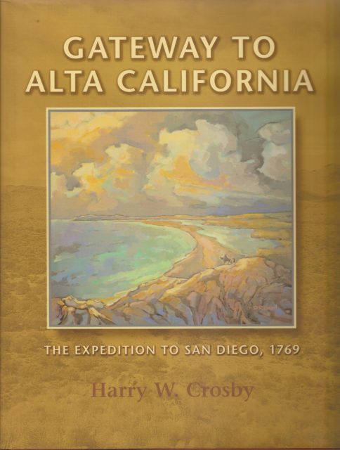
Also, the final leg of Serra's route (from San Fernando de Velicatá to San Diego) is exactly located in Harry Crosby's 2003 'Gateway to Alta
California'. It wasn't the best choice of names for a title (since it is 95% about Baja California), many did not buy it.

Some links to ECR maps and more:
https://vivabaja.com/hgreal/
https://vivabaja.com/ecr/
https://vivabaja.com/ecr-crossings/
|
|
|
cupcake
Senior Nomad
Posts: 828
Registered: 4-23-2024
Member Is Offline
|
|
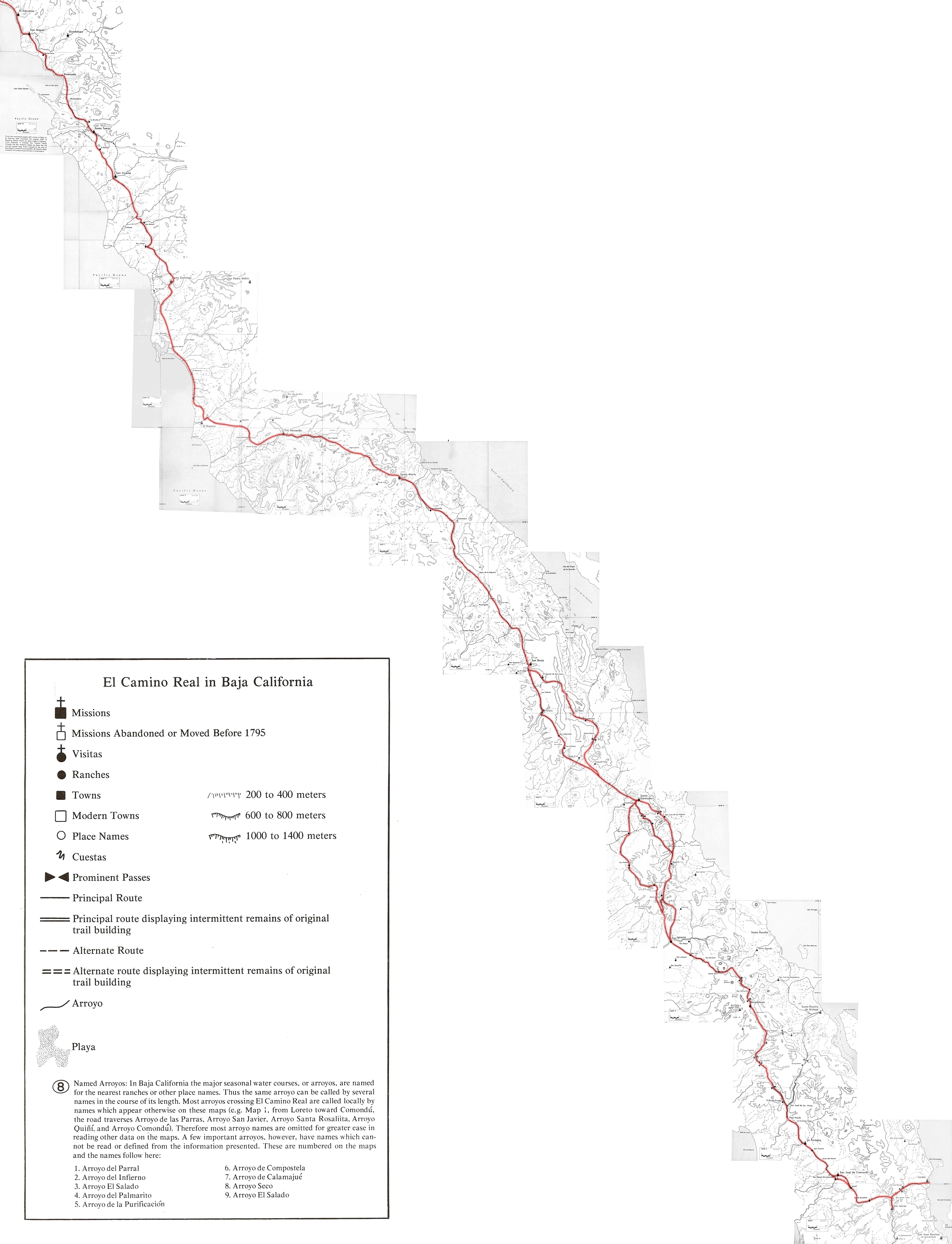
https://octopup.org/img/misc/davidk/ecr/ecr-maps-1.jpg
The above link is to Crosby ECR maps combined, which probably shows what he meant by "parallel route". This link is to the map on David's website.
That is, David's mindblowing wealth of information website!
|
|
|
David K
Honored Nomad
Posts: 65553
Registered: 8-30-2002
Location: San Diego County
Member Is Offline
Mood: Have Baja Fever
|
|
I am so happy you are enjoying my site's content...
There were parallel trails between missions for a variety of reasons, not limited to:
1) Seasonal trails for water sources (west side of mountains, east side, along the top)
2) To visit various Native tribes (rancherias) or visiting stations/ chapels (visitas) between two missions.
3) A newer route was made to improves upon a previous route. [Just look at the trails radiating out from San Ignacio, north and south]
Just the Jesuits' way of giving us more things to explore!
|
|
|
cupcake
Senior Nomad
Posts: 828
Registered: 4-23-2024
Member Is Offline
|
|
Thanks for this information, David. And, thanks for being so generous with your Baja Almanac by making the PDF available on your website.
I've been looking at the ECR from Loreto to San Javier. According to Kevin and Genevieve, the ECR followed the arroyo out of Loreto until it was
forced up and out by waterfalls and cascades. I've read that the trail normally avoided arroyos because of the risk of flash floods, but apparently
there are some exceptions. I think the paved road from Loreto to San Javier now covers much of the original ECR, but there looks to be some of the old
trail left to walk in this section that is not under the pavement (in addition to that at the start, in the arroyo).
[Edited on 2-11-2025 by cupcake]
|
|
|
David K
Honored Nomad
Posts: 65553
Registered: 8-30-2002
Location: San Diego County
Member Is Offline
Mood: Have Baja Fever
|
|
Yes, where the paved road is on the north side of the canyon, climbing up, the older dirt road and ECR is on the south side. I have a photo in the
page I made giving the locations where ECR meets modern roads.
https://vivabaja.com/ecr-crossings/
[Edited on 2-11-2025 by David K]
|
|
|
cupcake
Senior Nomad
Posts: 828
Registered: 4-23-2024
Member Is Offline
|
|
That is a great photo, for showing the old dirt auto road and original ECR running close to each other. I guess I would have to keep my eyes peeled so
as not to miss walking on the sacred trail. Knowing that there is a difference in width between the two would help. It's good to know that one could
walk on some of the original trail in this section.
I rode a bicycle on the pavement of this section last year. Going back and walking it is attractive for me, because I know if I get into trouble I can
walk over to the pavement and stick out my thumb (and maybe some cash) for a ride back down the hill. 
[Edited on 2-11-2025 by cupcake]
|
|
|
David K
Honored Nomad
Posts: 65553
Registered: 8-30-2002
Location: San Diego County
Member Is Offline
Mood: Have Baja Fever
|
|
Indeed!
Do know that modern roads are on top of the Jesuit and later trails in many places. A lot is not, simply because car roads cannot go where mules can
and require a wider pathway up and down mountainsides.
|
|
|
4x4abc
Ultra Nomad
Posts: 4455
Registered: 4-24-2009
Location: La Paz, BCS
Member Is Offline
Mood: happy - always
|
|
| Quote: Originally posted by cupcake | That is a great photo, for showing the old dirt auto road and original ECR running close to each other. I guess I would have to keep my eyes peeled so
as not to miss walking on the sacred trail. Knowing that there is a difference in width between the two would help. It's good to know that one could
walk on some of the original trail in this section.
I rode a bicycle on the pavement of this section last year. Going back and walking it is attractive for me, because I know if I get into trouble I can
walk over to the pavement and stick out my thumb (and maybe some cash) for a ride back down the hill.
[Edited on 2-11-2025 by cupcake] |
Camino Real from Loreto to Mision San Javier does not run through Las Parras!
It was the route to the first San Javier site.
Camino Real from Loreto to San Javier runs through Primera Agua and Rancho Incha
Harald Pietschmann
|
|
|
| Pages:
1
2
3
4
5
6 |


