| Pages:
1
2
3
4
5
6 |
bryanmckenzie
Senior Nomad

Posts: 561
Registered: 9-23-2009
Location: 400 Km from Mexico Beach, Florida
Member Is Offline
Mood: Hot & humid --- not hot & dry.
|
|
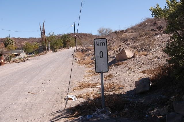
San Quintin Km 196 = Km 0

Southbound, Km 196 = Km 0

[Edited on 2011-5-27 by bryanmckenzie]
“Travel is fatal to prejudice, bigotry, and narrow-mindedness.”
-Mark Twain
Samuel Langhorne Clemens (November 30, 1835 – April 21, 1910)
|
|
|
David K
Honored Nomad
Posts: 65556
Registered: 8-30-2002
Location: San Diego County
Member Is Offline
Mood: Have Baja Fever
|
|
Cool you got the highway narrowing sign! This is the point of the final section of Highway 1 to be built... all in the year 1973: San Quintin to San
Ignacio/ Santa Rosalia. Seems they made the highway a foot narrower so the amount of asphalt could be squeezed on south! Now, almost 40 years later
they are finally widening sections of the skinny highway north and south of El Rosario.
In 1972 the highway crews working north from La Paz had already passed Santa Rosalia and were working on the really tough grades up to San Ignacio. In
early '73, we had learned that the new highway would not follow the main road route through El Arco, but instead swing out west to Guerrero Negro. El
Arco would get a paved 'driveway' (Mexico Hwy. 18), but with so thin a layer of asphalt, it broke apart ver soon after it was made!
|
|
|
bryanmckenzie
Senior Nomad
Posts: 561
Registered: 9-23-2009
Location: 400 Km from Mexico Beach, Florida
Member Is Offline
Mood: Hot & humid --- not hot & dry.
|
|
Great information David. Thanks. I'm a full year behind chronicalling last year's trip and so am just now discovering (remembering?) the many, many
pictures of road signs & road construction I took. Literally hundreds trying to document the ever-changing peninsula. It's hard to believe how
much money is flowing back into the peninsula in the form of public works projects.
|
|
|
GregN
Nomad
Posts: 102
Registered: 5-13-2004
Location: Palm Springs
Member Is Offline
|
|
In the back pages of my book "Baja Fever," I can be seen leaning against a "Kilometer 0 " sign taken in Cabo San Lucas.
|
|
|
bryanmckenzie
Senior Nomad
Posts: 561
Registered: 9-23-2009
Location: 400 Km from Mexico Beach, Florida
Member Is Offline
Mood: Hot & humid --- not hot & dry.
|
|
Where is this one? Is it Hwy 1?
Where is this one? Doesn't really look like Hwy 1? Unless it's from David K's early days in Baja. 
Seen in this thread.
[Edited on 2011-5-28 by bryanmckenzie]
|
|
|
Ateo
Elite Nomad
Posts: 5962
Registered: 7-18-2011
Member Is Offline
|
|
Anyone drove the km 252 road to Bahia Blanco lately?
|
|
|
TMW
Select Nomad
Posts: 10659
Registered: 9-1-2003
Location: Bakersfield, CA
Member Is Offline
|
|
Not exactly but I did take the KM270 turn off that joins up with the KM 252 road about 5 or 6 miles in from the hwy. Road was in good shape. The first
rancho before San Antonio appeared to be abandoned as is the rancho when you exit the mountains at the sand wash. When you get down out of the
mountains there are a lot of lines thru the silt beds but it was all hard pack and easy to get thru. I went thru there Nov 20th after the 1000 race.
Spent the night at Bahia Blanco then went north along the coast and out north of Catavina at hwy 1 KM168. Lots of muddy water puddles at that time on
the graded road from San Jose to hwy 1 from the rain.
|
|
|
Ateo
Elite Nomad
Posts: 5962
Registered: 7-18-2011
Member Is Offline
|
|
Excellent TW. Heading in there in February with a 4x4 Tacoma and non 4x4 2010 Tundra. Will a smart non 4x4 driver need 4x4?
|
|
|
TMW
Select Nomad
Posts: 10659
Registered: 9-1-2003
Location: Bakersfield, CA
Member Is Offline
|
|
The Tundra should be OK. While I was in 4x4 I never felt I needed it since the ground was hard packed. If it is wet then I would be more cautous. A
smart driver just picks good lines. You'll be OK. I only got confused one time. After getting down from the mountains into the wash and past rancho
Las Palomas (it's seen on the right) I thought the road followed down the middle of the valley so I turned right and wound up at basically a dead end,
turned around and went back and around the hills to whats called Cordornices area where the jct with the road south is. The well with the wind mill is
still standing but I don't think the windmill is working. Near Bahia Blanco there was a lot of cattle grazing on the east side of the north/south
road.
|
|
|
Ateo
Elite Nomad
Posts: 5962
Registered: 7-18-2011
Member Is Offline
|
|
| Quote: | Originally posted by TW
The Tundra should be OK. While I was in 4x4 I never felt I needed it since the ground was hard packed. If it is wet then I would be more cautous. A
smart driver just picks good lines. You'll be OK. I only got confused one time. After getting down from the mountains into the wash and past rancho
Las Palomas (it's seen on the right) I thought the road followed down the middle of the valley so I turned right and wound up at basically a dead end,
turned around and went back and around the hills to whats called Cordornices area where the jct with the road south is. The well with the wind mill is
still standing but I don't think the windmill is working. Near Bahia Blanco there was a lot of cattle grazing on the east side of the north/south
road. |
TW: thanks for your input. I can't wait to go! This is a section of Baja I've never been to. I've done the sections north and south of here but
never Blanco. I think we may take your route back out too since I want to check Vibora and Baja Bob
|
|
|
Ateo
Elite Nomad
Posts: 5962
Registered: 7-18-2011
Member Is Offline
|
|
| Quote: | Originally posted by David K
| Quote: | Originally posted by TW
The Tundra should be OK. While I was in 4x4 I never felt I needed it since the ground was hard packed. If it is wet then I would be more cautous. A
smart driver just picks good lines. You'll be OK. I only got confused one time. After getting down from the mountains into the wash and past rancho
Las Palomas (it's seen on the right) I thought the road followed down the middle of the valley so I turned right and wound up at basically a dead end,
turned around and went back and around the hills to whats called Cordornices area where the jct with the road south is. The well with the wind mill is
still standing but I don't think the windmill is working. Near Bahia Blanco there was a lot of cattle grazing on the east side of the north/south
road. |
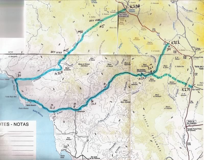
Here's the 'TW LOOP' map I made a couple years ago to show the road that heads in at Laguna Chapala and runs 30 miles to the coast road... Then south
12.5 miles on the coast road...and back out via San Antonio to Hwy. 1 in 34 miles...
[Edited on 12-4-2011 by David K] |
Thanks DK. I was thinking about taking the Laguna Chapala route on my way back out but after looking at my Baja almanac it barely shows a road here.
Maybe I'll just go back out the way I came in or head a little further north along the coast and cut over there.
|
|
|
David K
Honored Nomad
Posts: 65556
Registered: 8-30-2002
Location: San Diego County
Member Is Offline
Mood: Have Baja Fever
|
|
No, the Almanac (or any other map does NOT show the road from Chapala to the coast. None-the-less, it is there and TW has documented it and you can
see it on Google Earth (that is how I located and placed it on the map above).
There are other roads in Baja that are fine, but not yet on a map...
|
|
|
woody with a view
PITA Nomad
Posts: 15940
Registered: 11-8-2004
Location: Looking at the Coronado Islands
Member Is Offline
Mood: Everchangin'
|
|
if there is any rain your non 4x buddy will enjoy the pucker factor. the road out from SJ is getting worse every time. they blasted the granite rock
face near the shrine so that is better but there is more areas of silt developing as time goes by. and after a rain? 
|
|
|
TMW
Select Nomad
Posts: 10659
Registered: 9-1-2003
Location: Bakersfield, CA
Member Is Offline
|
|
If you are going to take the road out to Laguna Chapala I suggest on your way down to turn off on it at KM234 and drive back to the first dry lake to
make sure it's dry. It's about 4 mile back and you'll see the black hill I spoke of in the write up with pictures. Some years there is as much as 1 to
2 feet of water on it and while the bottom is hard pack there are holes you could fall into. The water covers the road and makes it hard to follow to
get past the hill. The other two dry lake beds the road skirts around the edge, no problem. Lots of cross roads and parallel roads and slit beds near
the ocean. Again not a problem if it hasn't rained much. When coming out follow the most used road as you drive east up the valley to the mountain
crest. The local fishermen use this road daily when it passable. The GPS turn off at the ocean is 29-10-49x114-44-20 in Hrs-Mins-Sec, Datum 27.
I was last on this road in Nov. 2010.
[Edited on 12-4-2011 by TW]
|
|
|
Ateo
Elite Nomad
Posts: 5962
Registered: 7-18-2011
Member Is Offline
|
|
| Quote: | Originally posted by woody with a view
if there is any rain your non 4x buddy will enjoy the pucker factor. the road out from SJ is getting worse every time. they blasted the granite rock
face near the shrine so that is better but there is more areas of silt developing as time goes by. and after a rain? |
Thanks for the confidence boost! . I think it'll be a quick strike mission so I probably won't head out that SJ road. I'll take one of these from
Chapala or km252. . I think it'll be a quick strike mission so I probably won't head out that SJ road. I'll take one of these from
Chapala or km252.
|
|
|
woody with a view
PITA Nomad
Posts: 15940
Registered: 11-8-2004
Location: Looking at the Coronado Islands
Member Is Offline
Mood: Everchangin'
|
|
beware the silt. stories have circulated of the army hummer that was stuck in the silty mud for 3 days until other soldiers found them and pulled them
out. they took the wrong line!
|
|
|
TMW
Select Nomad
Posts: 10659
Registered: 9-1-2003
Location: Bakersfield, CA
Member Is Offline
|
|
The road from San Jose to hwy 1 is a very good graded road. Last week there were several places where it was muddy (red mud) with standing water but
it was hard packed so getting stuck was not an issue. Saw several large trailers and a couple of motorhomes at San Jose, maybe the results of that
good road.
|
|
|
Ateo
Elite Nomad
Posts: 5962
Registered: 7-18-2011
Member Is Offline
|
|
| Quote: | Originally posted by David K
Okay, back to the topic... anyone have a list or just one kilometer marker that locates a place or sideroad to share... or the other sub topic: a
photo of a kilometer marker? |
Sorry to go off topic there briefly......I'll take a look for km markers when I get home.
|
|
|
GregN
Nomad
Posts: 102
Registered: 5-13-2004
Location: Palm Springs
Member Is Offline
|
|
This one of me at Kilometer 0 in Cabo is in the back of my book Baja Fever.
|
|
|
TMW
Select Nomad
Posts: 10659
Registered: 9-1-2003
Location: Bakersfield, CA
Member Is Offline
|
|
Sometime in 2012 I'm going to drive down hwy 1 and do an update on the kilometer markers as many have changed for whatever reason. May do it in two
trips, the NORRA race and the SCORE Baja 1000 since both will go to La Paz next year.
|
|
|
| Pages:
1
2
3
4
5
6 |


