| Pages:
1
2
3
4
5 |
TMW
Select Nomad
      
Posts: 10659
Registered: 9-1-2003
Location: Bakersfield, CA
Member Is Offline
|
|
Yes
|
|
|
John M
Super Nomad
   
Posts: 1924
Registered: 9-3-2003
Location: California High Desert
Member Is Offline
|
|
Fuel concern
Obviously the range for the bikes will determine your chances insofar as re-fueling. Once concern I'd have is that if there is a gate you simply
cannot bypass, now what? Return to the start - would you have fuel to do that - of course it depends on where the gate is.
Reports of better roads replacing the rocky slow stuff we encountered will help to determine at the time just how far in your chase vehicle will want
to go.
I assume you will be in communication with the chase crew in the event you'd need to turn around to where you "started."
From Rancho La Ilusion on the northern end the dirt road was in and out of washes, a couple of very rocky dry wash crossings and then somewhere about
4 miles south of La Ilusion was a steep rutted hill climb of 1/4 mile.
From the San Ignacio side it was, in 2017, a decent dirt road as far as El Gato, slow in spots for a pick-up, 4WD wasn't necessary for that section.
Remember that this was April of 2017 and Desert Bull's report was after our adventure and he is one of those who reported much better conditions.
Our group encountered no locked gates, the gate at La Ilusion south of El Barril has been open the several times we went through it. Desert Bull made
no mention of gates either as far as I recall.
John M
|
|
|
4x4abc
Ultra Nomad
    
Posts: 4454
Registered: 4-24-2009
Location: La Paz, BCS
Member Is Offline
Mood: happy - always
|
|
if there are locked gates, they will be close to Rancho San Miguel.
So, no problem to turn around when you come from El Barril.
Coming from the south and turning around at locked gates around San Miguel will require extra gas.
One locked gate reported here:
28° 1'33.33"N, 112°48'16.47"W
Harald Pietschmann
|
|
|
John M
Super Nomad
   
Posts: 1924
Registered: 9-3-2003
Location: California High Desert
Member Is Offline
|
|
No problem Harald - unless
Unless the chase vehicle has gone on to the San Ignacio to wait for them. John
|
|
|
JZ
Select Nomad
      
Posts: 13943
Registered: 10-3-2003
Member Is Offline
|
|
Based on TWM's input and DesertBull's post, gonna try to take my truck through. Camp out a little North of Trinidad.
[Edited on 11-5-2018 by JZ]
|
|
|
David K
Honored Nomad
        
Posts: 65436
Registered: 8-30-2002
Location: San Diego County
Member Is Offline
Mood: Have Baja Fever
|
|
InReach, satellite 2-way communication (or Sat phones) for the win!
|
|
|
BajaRun
Nomad
 
Posts: 222
Registered: 2-25-2012
Member Is Offline
Mood: Just Cruisin'
|
|
Are all of the mentioned trails wide enough for a Big Wide Prerunner Buggy ?
|
|
|
4x4abc
Ultra Nomad
    
Posts: 4454
Registered: 4-24-2009
Location: La Paz, BCS
Member Is Offline
Mood: happy - always
|
|
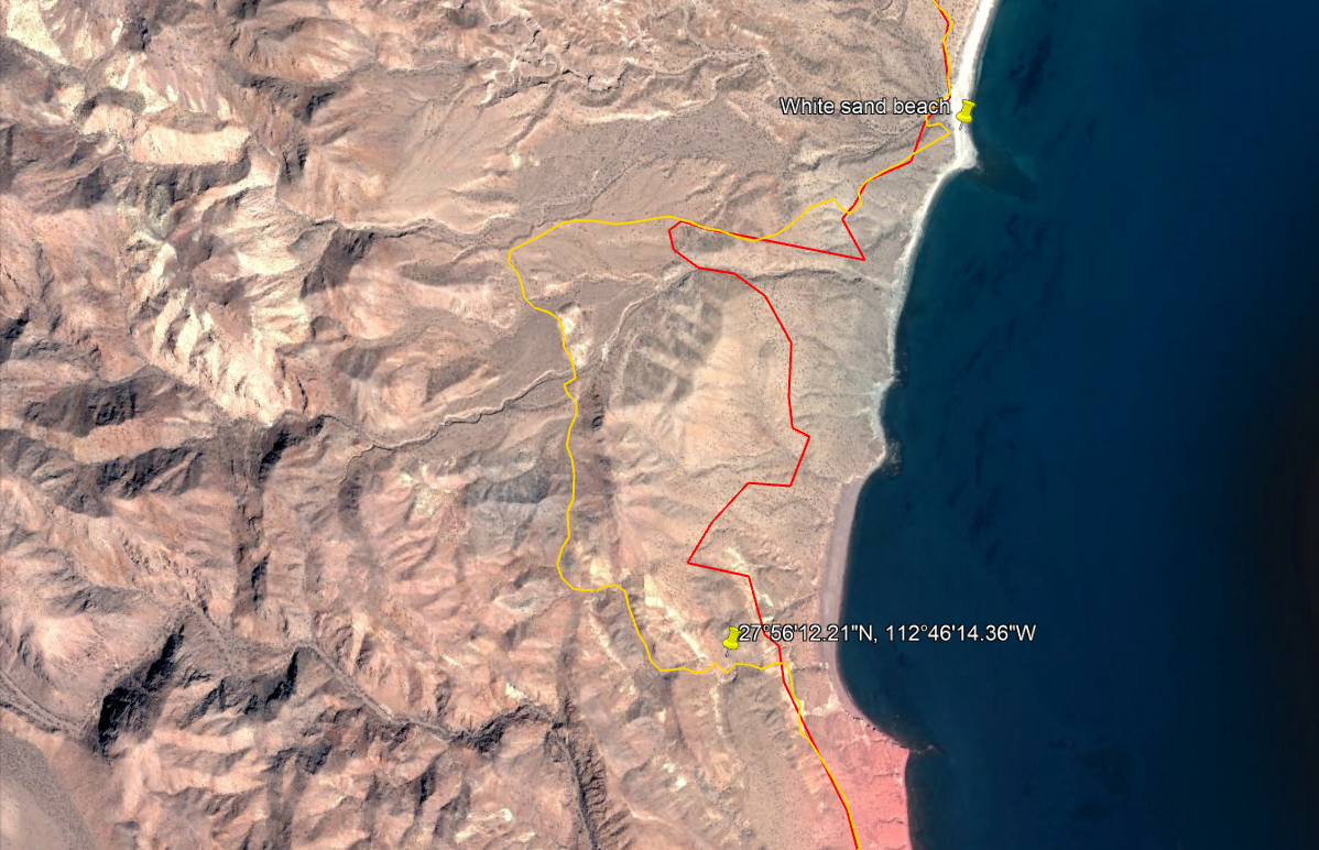
it gets very tight around here:
27°56'12.21"N, 112°46'14.36"W
would not take any wide vehicle on that trail
that is with knowledge from 2 years ago
if CFE has already dozed the new access trail for the proposed power line it will be wide enough for big trucks
Harald Pietschmann
|
|
|
JZ
Select Nomad
      
Posts: 13943
Registered: 10-3-2003
Member Is Offline
|
|
Quote: Originally posted by 4x4abc  | it gets very tight around here:
27°56'12.21"N, 112°46'14.36"W
would not take any wide vehicle on that trail
that is with knowledge from 2 years ago
if CFE has already dozed the new access trail for the proposed power line it will be wide enough for big trucks |
That spot isn't on either of the set of of tracks I have. So, we'll see.
|
|
|
4x4abc
Ultra Nomad
    
Posts: 4454
Registered: 4-24-2009
Location: La Paz, BCS
Member Is Offline
Mood: happy - always
|
|
on a bike you would run a different track (too narrow for cars though)
http://baja101.com/Baja-GPS/NoWimp.kmz
Harald Pietschmann
|
|
|
JZ
Select Nomad
      
Posts: 13943
Registered: 10-3-2003
Member Is Offline
|
|
Which one is the truck route, yellow?

|
|
|
geoffff
Senior Nomad
  
Posts: 710
Registered: 1-15-2009
Member Is Offline
|
|
Yes, if you look at the file contents/properties of the track 4x4abc just posted, the route you colored red is labeled "bike", and the yellow one is
labeled "4x4 rural".
|
|
|
JZ
Select Nomad
      
Posts: 13943
Registered: 10-3-2003
Member Is Offline
|
|
Ok, I see that now.
|
|
|
4x4abc
Ultra Nomad
    
Posts: 4454
Registered: 4-24-2009
Location: La Paz, BCS
Member Is Offline
Mood: happy - always
|
|
when the road to Rancho La Trinidad was built, a shortcut n the canyon was also established.
Haven't driven it yet, but for the next group of adventurers this would be cool.
http://baja101.com/Baja-GPS/shortcut.kmz
La Trinidad must have had some importance as it has an airstrip
Harald Pietschmann
|
|
|
JZ
Select Nomad
      
Posts: 13943
Registered: 10-3-2003
Member Is Offline
|
|
Keep the knowledge coming!!
|
|
|
4x4abc
Ultra Nomad
    
Posts: 4454
Registered: 4-24-2009
Location: La Paz, BCS
Member Is Offline
Mood: happy - always
|
|
some secrets need to be kept
Harald Pietschmann
|
|
|
JZ
Select Nomad
      
Posts: 13943
Registered: 10-3-2003
Member Is Offline
|
|
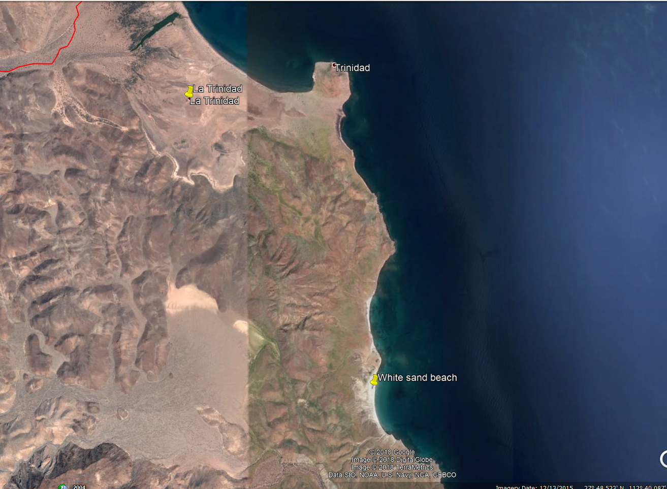
Have you ever gone to the beach 2.5 miles below Trinadad? Wonder if there is a route.
Looks really nice. I went by there once in a boat, but we just flew by.

|
|
|
4x4abc
Ultra Nomad
    
Posts: 4454
Registered: 4-24-2009
Location: La Paz, BCS
Member Is Offline
Mood: happy - always
|
|
yes, you can get with a 4x4 to the beaches south of La Trinidad
adventurous drive
south of that is a trail from missionary times following Arroyo Portezuelo to Arroyo San Carlos
Harald Pietschmann
|
|
|
twgracing
Junior Nomad

Posts: 36
Registered: 10-28-2011
Location: Imperial Valley
Member Is Offline
|
|
I wouldn't suggest taking anything other than 4x4. Plenty wide but the wash after trinidad is rock crawling.
|
|
|
PaulW
Ultra Nomad
    
Posts: 3113
Registered: 5-21-2013
Member Is Offline
|
|
Time to do it. Sadly my schedule wont allow until early January
Anybody available in Jan?
|
|
|
| Pages:
1
2
3
4
5 |

