| Pages:
1
2
3
4
5
..
10 |
4x4abc
Ultra Nomad

Posts: 4455
Registered: 4-24-2009
Location: La Paz, BCS
Member Is Offline
Mood: happy - always
|
|
those early 1900's maps are very frustrating
they seem to be based on hearsay and not so much on survey
many names are out of place
looking at satellite data with passable valleys, visible trails and known water sources, completely different routes emerge than what the maps
suggest
Harald Pietschmann
|
|
|
David K
Honored Nomad
Posts: 65562
Registered: 8-30-2002
Location: San Diego County
Member Is Offline
Mood: Have Baja Fever
|
|
Quote: Originally posted by 4x4abc  | those early 1900's maps are very frustrating
they seem to be based on hearsay and not so much on survey
many names are out of place
looking at satellite data with passable valleys, visible trails and known water sources, completely different routes emerge than what the maps
suggest
|
Why I included the Gulick map, as it is very close to accurate, and the nearest such map to when Goldbaum drew his in 1918. It would surprise me if
the 1971 geology map, 10 years after Gulick's research wasn't accurate as well... and it includes Leon Grande, too.
|
|
|
Lance S.
Nomad
Posts: 237
Registered: 2-16-2021
Member Is Offline
|
|
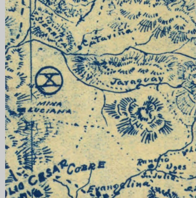
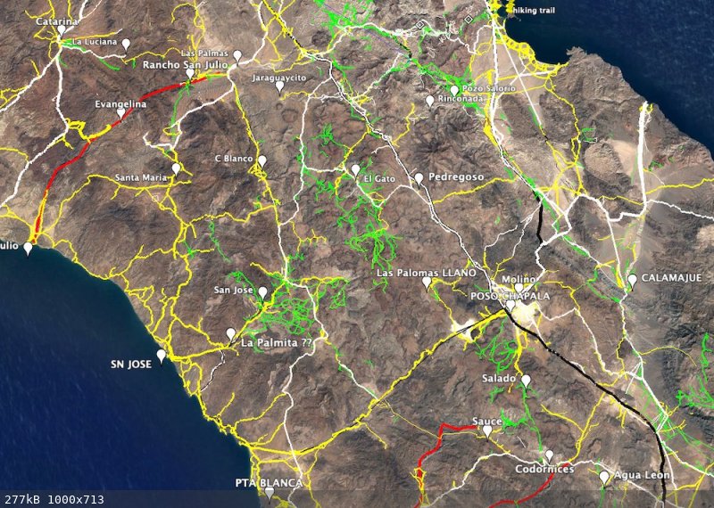
Next section of the map, San Julio to La Sierrita.
|
|
|
Lance S.
Nomad
Posts: 237
Registered: 2-16-2021
Member Is Offline
|
|
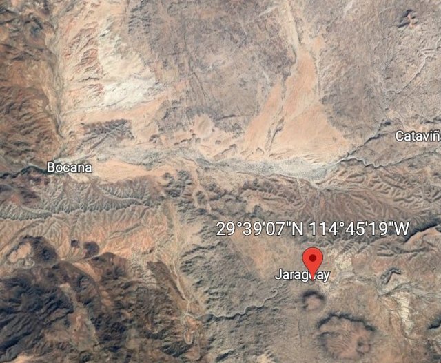
To help understand this section of the map, the location below is that hill just above Rancho San Julio. Ignore Jaraguay, it is in the wrong place
as will be explained.
[Edited on 4-19-2023 by Lance S.]
|
|
|
David K
Honored Nomad
Posts: 65562
Registered: 8-30-2002
Location: San Diego County
Member Is Offline
Mood: Have Baja Fever
|
|
Someone said San Julio was today's Rancho La Bocana.
What say you?
|
|
|
Lance S.
Nomad
Posts: 237
Registered: 2-16-2021
Member Is Offline
|
|
Rancho San Julio was in that side canyon just below the ecotourism place
[Edited on 4-19-2023 by Lance S.]
|
|
|
4x4abc
Ultra Nomad
Posts: 4455
Registered: 4-24-2009
Location: La Paz, BCS
Member Is Offline
Mood: happy - always
|
|
here are the names off the Goldbaum map put on the location with a matching name
major mixup with the points along the coast and the Arroyos

Harald Pietschmann
|
|
|
Lance S.
Nomad
Posts: 237
Registered: 2-16-2021
Member Is Offline
|
|
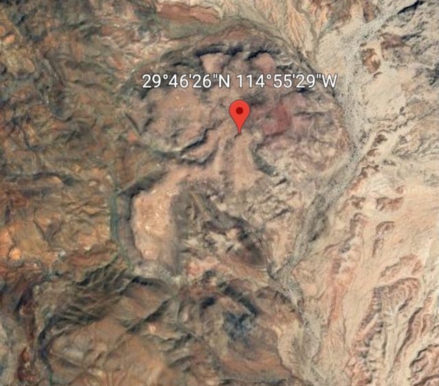
Do you have mina Luciana?
|
|
|
4x4abc
Ultra Nomad
Posts: 4455
Registered: 4-24-2009
Location: La Paz, BCS
Member Is Offline
Mood: happy - always
|
|
it is north of the image:
29° 42.336'N, 115° 0.853'W
Harald Pietschmann
|
|
|
Lance S.
Nomad
Posts: 237
Registered: 2-16-2021
Member Is Offline
|
|
Nice, thank you
[Edited on 4-19-2023 by Lance S.]
|
|
|
Lance S.
Nomad
Posts: 237
Registered: 2-16-2021
Member Is Offline
|
|
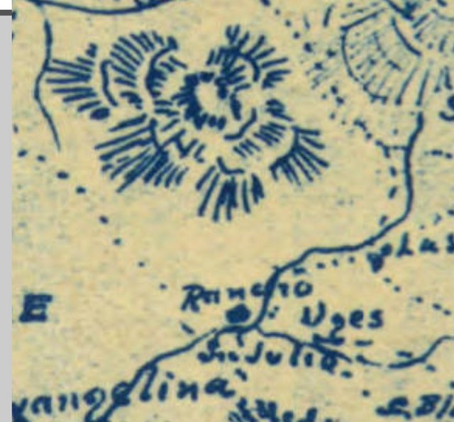
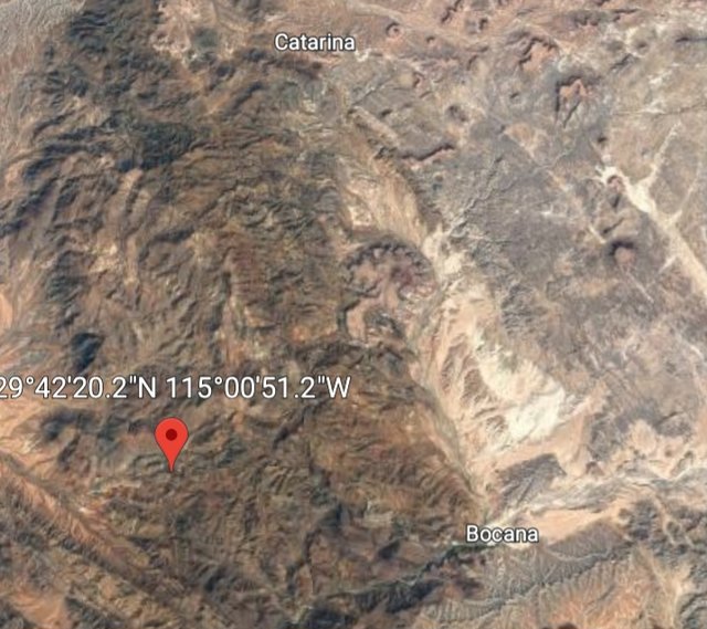
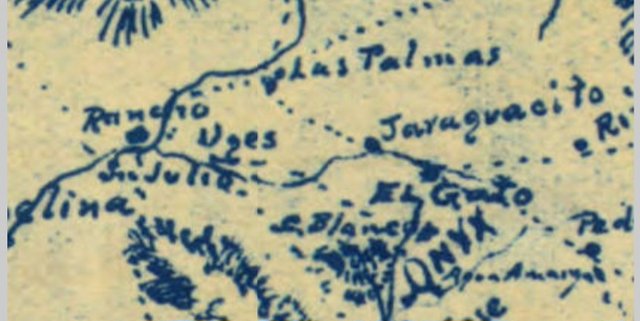
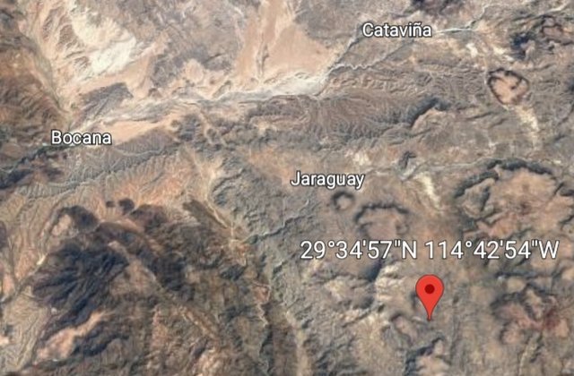
Mentally erase Arroyo Jaraguay from the Goldbaum map when comparing the two images above. It is surprisingly accurate.
Do you see it? Goldbaum doesn't say Catavina, it says Catarina.
[Edited on 4-19-2023 by Lance S.]
|
|
|
4x4abc
Ultra Nomad
Posts: 4455
Registered: 4-24-2009
Location: La Paz, BCS
Member Is Offline
Mood: happy - always
|
|
one more time
Harald Pietschmann
|
|
|
Lance S.
Nomad
Posts: 237
Registered: 2-16-2021
Member Is Offline
|
|
Arroyos Jaraguay and Jaraguacito are shown on Goldbaum. Las Palmas is on Arroyo Jaraguay. They are shown flowing into Arroyo San Julio instead of
Arroyo Cuervitas.
Las Palmas
|
|
|
Lance S.
Nomad
Posts: 237
Registered: 2-16-2021
Member Is Offline
|
|
Jaraguacito
[Edited on 4-19-2023 by Lance S.]
|
|
|
David K
Honored Nomad
Posts: 65562
Registered: 8-30-2002
Location: San Diego County
Member Is Offline
Mood: Have Baja Fever
|
|
My Facebook chat with Juan, owner of Rancho Las Palomas, if you have questions for him.
This exchange may be of interest to Nomads that recall my April 2017 trip to this area. This was following the photos I posted of the adobe at
Codornices (San Antonio) from 'geoffff' [Juan's words are auto-translated to English]:
Juan Carlos Aviña Ornelas:
In those conditions I met that ranch in 1970.
Eventually I pass through the ruins of that ranch today.
I am an ejidatarian of San Jose de las Palomas and one of the access routes to the ejido where I belong is this.
David Kier:
Juan Carlos Aviña Ornelas, It is great to hear from you. I am currently talking with the Arce/ Torres (Rancho San Luis) family who are related to
Teodoro Estrada Zúñiga of this ranch (Codornices).
Juan Carlos Aviña Ornelas:
David Kier, Thank you very much for the attention.
I am the owner of RANCHO LAS PALOMAS, in ejido San Jose de las Palomas, about 30 kilometers west of Rancho Codornices.
Kind regards.
David Kier:
Juan Carlos Aviña Ornelas, Do you know what happened with Rancho La Miseria, near you? I 'rescued' Leo and Lorena Durazo, who flagged me down for
help, and ended up driving them both south to Santa Rosalillita and then to Punta Prieta. Lorena told me they had been abandoned and unpaid by the
ranch owner and were in need of food and medicine for Leo's bad heart condition. What a night, driving all in the dark!
This was my satellite text message to Antonio Muñoz of the Baja Cactus Motel and Pemex, in El Rosario: Apr 23, 2017 6:02 PM:
Hola Antonio, tengo emergencia with the couple at Rancho Miseria de Candelario. Their truck broke miles away. They need heart meds and food [abandoned
here for] 2 months. … Señor Candelario Aguire Arce is the owner. He has taxis in Rosarito. … They have no food or medicine. … Can you get ahold
of him to bring help to his employees stuck here? On the San Antonio road, east of Bahia Blanco. … Leo y Lorena Durazo.
Juan Carlos Aviña Ornelas:
David Kier, I have knowledge that LEO already died and LORENA back to Tijuana with her family.
The Ranch of Misery is the same, it's still abandoned and vandalized.
One of the causes was the exceptional Drought affecting our state.
---------------------------------------------------------------------------------------------------------------------------------------
If you guys want me to ask Juan any questions about his Rancho Las Palomas or the Ejido de San José de las Palomas, let me know!
|
|
|
Lance S.
Nomad
Posts: 237
Registered: 2-16-2021
Member Is Offline
|
|
If you talk to the family who owns San Antonio again I an curious if they know who Tinaja Ortiz is named after.
|
|
|
4x4abc
Ultra Nomad
Posts: 4455
Registered: 4-24-2009
Location: La Paz, BCS
Member Is Offline
Mood: happy - always
|
|
how did you get the locations for Las Palmas and Jaraguaycito?
Harald Pietschmann
|
|
|
David K
Honored Nomad
Posts: 65562
Registered: 8-30-2002
Location: San Diego County
Member Is Offline
Mood: Have Baja Fever
|
|
| Quote: Originally posted by Lance S. | | If you talk to the family who owns San Antonio again I an curious if they know who Tinaja Ortiz is named after. |
San Antonio/ Los Codornices, yes... I am chatting with them almost daily as I am working on the family tree of Eliodoro Arce. Just added dozens more
names!
How far is Tinaja Ortiz from the adobe at Codornices/ San Antonio?
|
|
|
PaulW
Ultra Nomad
Posts: 3113
Registered: 5-21-2013
Member Is Offline
|
|
Can you pin point where they live. I noticed a well traveled road looping just south of San Antonio ruins?
No roads visible on GE.
|
|
|
David K
Honored Nomad
Posts: 65562
Registered: 8-30-2002
Location: San Diego County
Member Is Offline
Mood: Have Baja Fever
|
|
Well, nobody lives at the adobe or nearby... a ranch house is a couple miles east, just south of the road, but it looked abandoned when I went by. Not
sure geoffff commented on it? Then, just off the road that comes south from Km. 252, is a ranch.
I will ask where they live, currently chatting with Gardenia Cota (daughter of the owner, José Cota Zúñiga & Dolores Gaxiola Arce) and with
(via his cousin) Teodoro Estrada Zúñiga (son of Salvador Estrada & Antonia (Toña) Zúñiga Arce).
This Arce family, connected with Eliodoro is huge!
|
|
|
| Pages:
1
2
3
4
5
..
10 |


