| Pages:
1
2
3
4
5 |
David K
Honored Nomad

Posts: 65550
Registered: 8-30-2002
Location: San Diego County
Member Is Offline
Mood: Have Baja Fever
|
|
Yes, Howard Gulick was THE Baja guy who logged and mapped all the roads back in the 1950s and early 60s....
His book remains an excellent source for data on Baja's backcountry and history...
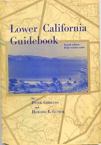
Don't you love that cover photo with our favorite palm tree? The photo was taken in 1953, and the palm still remains just above the high tide line,
66 years later!  
|
|
|
David K
Honored Nomad
Posts: 65550
Registered: 8-30-2002
Location: San Diego County
Member Is Offline
Mood: Have Baja Fever
|
|
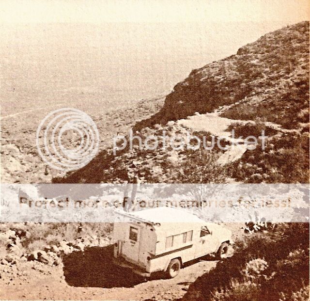
The old Hwy. 1
East of San Ignacio, photo from late 1960s:
|
|
|
4x4abc
Ultra Nomad
Posts: 4455
Registered: 4-24-2009
Location: La Paz, BCS
Member Is Offline
Mood: happy - always
|
|
here are the Cuestas
Harald Pietschmann
|
|
|
4x4abc
Ultra Nomad
Posts: 4455
Registered: 4-24-2009
Location: La Paz, BCS
Member Is Offline
Mood: happy - always
|
|
and here is La Cuesta Vieja at Tres Virgines
Harald Pietschmann
|
|
|
4x4abc
Ultra Nomad
Posts: 4455
Registered: 4-24-2009
Location: La Paz, BCS
Member Is Offline
Mood: happy - always
|
|
looks like Cuesta La Virgen to me
Harald Pietschmann
|
|
|
Pablito1
Junior Nomad
Posts: 73
Registered: 4-24-2011
Member Is Offline
|
|
Harald,
Did you know Harry Kemp the retired policeman that lived at Papa Fernandez camp? Harry told me that the big hill of which the photo is of was called
"Jim Beam" hill of course that was a Gringo name.
Regards
|
|
|
David K
Honored Nomad
Posts: 65550
Registered: 8-30-2002
Location: San Diego County
Member Is Offline
Mood: Have Baja Fever
|
|
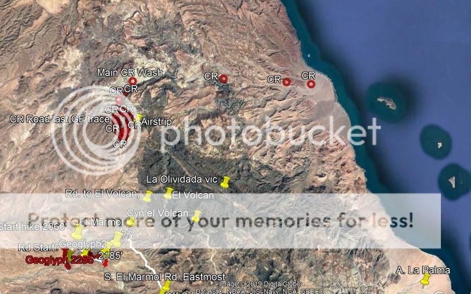
Harald, did you drive the old dirt road south of Puertecitos (before 1986)?
Interesting stuff on your Google Earth. I like the CR marks. Looks like you also were seeking a route between Hwy. 1 and Hwy. 5 as some of us have?
How did you come to apply the cuesta names where you did?
You could be right about the cuesta of my photo.
|
|
|
4x4abc
Ultra Nomad
Posts: 4455
Registered: 4-24-2009
Location: La Paz, BCS
Member Is Offline
Mood: happy - always
|
|
I have been driving all the old roads between Puertecitos and Alfonsinas after 1986 - many times with clients as an off-road adventure
the names are from a variety of maps and government papers from the last construction (Pavement)
there are several connections between MEX1 and MEX5 - most are old mining trails. One is drivable with a serious 4x4 or MC.
Took my friend Pete from Huerfanitos 20 years ago. He still tells friends about my attempt to kill him on the way up.
After the negative response to our east-west crossing through Las Tarabillas I decided to no longer publish where i have been in Baja.
https://carlosnpainter.smugmug.com/Events/Uno-Baja-Extreme-A...
interesting that you have CR marks - my file does not show any. Got a picture?
Harald Pietschmann
|
|
|
David K
Honored Nomad
Posts: 65550
Registered: 8-30-2002
Location: San Diego County
Member Is Offline
Mood: Have Baja Fever
|
|
Quote: Originally posted by 4x4abc  | I have been driving all the old roads between Puertecitos and Alfonsinas after 1986 - many times with clients as an off-road adventure
the names are from a variety of maps and government papers from the last construction (Pavement)
there are several connections between MEX1 and MEX5 - most are old mining trails. One is drivable with a serious 4x4 or MC.
Took my friend Pete from Huerfanitos 20 years ago. He still tells friends about my attempt to kill him on the way up.
After the negative response to our east-west crossing through Las Tarabillas I decided to no longer publish where i have been in Baja.
https://carlosnpainter.smugmug.com/Events/Uno-Baja-Extreme-A...
interesting that you have CR marks - my file does not show any. Got a picture? |
The photos appear to be those from Baja Sur, not west from Huerfanito?
Where is Las Tarabillas?
The CR (Coast Route) points I saw after I loaded your kmz file were actually from Neal Johns... as he was one of us searching for a vehicle route
between the two highways. This one was from near El Mármol to near El Huerfanito.
|
|
|
4x4abc
Ultra Nomad
Posts: 4455
Registered: 4-24-2009
Location: La Paz, BCS
Member Is Offline
Mood: happy - always
|
|
Arroyo Las Tarabillas: 24°27'20.69"N, 110°46'26.89"W
Harald Pietschmann
|
|
|
David K
Honored Nomad
Posts: 65550
Registered: 8-30-2002
Location: San Diego County
Member Is Offline
Mood: Have Baja Fever
|
|
OH, well... that is why I didn't get the photo link you posted... we were speaking of Hwy. 1 to Hwy. 5 near El Huerfanito, and you had that crossing
in mind, instead! Thanks for clearing that up Harald!
Does Karl have all the Baja books he got from me where you can get to them to read? If not, just let me know what you need a look at and I will try
and find that in the old books of Baja I have.
|
|
|
4x4abc
Ultra Nomad
Posts: 4455
Registered: 4-24-2009
Location: La Paz, BCS
Member Is Offline
Mood: happy - always
|
|
haven't had contact with Karl for while.
Harald Pietschmann
|
|
|
4x4abc
Ultra Nomad
Posts: 4455
Registered: 4-24-2009
Location: La Paz, BCS
Member Is Offline
Mood: happy - always
|
|
| Quote: Originally posted by Pablito1 | Harald,
Did you know Harry Kemp the retired policeman that lived at Papa Fernandez camp? Harry told me that the big hill of which the photo is of was called
"Jim Beam" hill of course that was a Gringo name.
Regards |
never met Harry Kemp
Harald Pietschmann
|
|
|
4x4abc
Ultra Nomad
Posts: 4455
Registered: 4-24-2009
Location: La Paz, BCS
Member Is Offline
Mood: happy - always
|
|
I did some digging on my old maps - seems like the image is of Cuesta el Huerfanito looking north. At the bottom of the hill is Campo Zavala Salome
Harald Pietschmann
|
|
|
David K
Honored Nomad
Posts: 65550
Registered: 8-30-2002
Location: San Diego County
Member Is Offline
Mood: Have Baja Fever
|
|
The only camps south of Puertecitos when I traveled the old road was El Huerfanito and Okie Landing. A guy worked the road for tips and left his wheel
barrel along the road seeking donations. Cliff Cross has a photo of him. I think he started Campo Salvatierra. Cinco Islas and Punta Bufeo came later.
|
|
|
4x4abc
Ultra Nomad
Posts: 4455
Registered: 4-24-2009
Location: La Paz, BCS
Member Is Offline
Mood: happy - always
|
|
Campo Zavala Salome was a Mexican fish camp - not a Gringo creation
Harald Pietschmann
|
|
|
4x4abc
Ultra Nomad
Posts: 4455
Registered: 4-24-2009
Location: La Paz, BCS
Member Is Offline
Mood: happy - always
|
|
Name reference on map H11B88
Harald Pietschmann
|
|
|
John Harper
Super Nomad
Posts: 2289
Registered: 3-9-2017
Location: SoCal
Member Is Offline
|
|
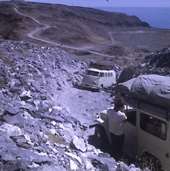
Love the VW bus shot!!!
John
|
|
|
David K
Honored Nomad
Posts: 65550
Registered: 8-30-2002
Location: San Diego County
Member Is Offline
Mood: Have Baja Fever
|
|
El Huerfanito and Okie Landing were also Mexican owned camps. The Mexicans asked their first clients (from Oklahoma) what would be a good name for
their new campo.
I have NEVER seen any place named "Campo Zavala Salome" in all the trips I took down there... nor was there any such name on any maps or books I have
seen.
|
|
|
4x4abc
Ultra Nomad
Posts: 4455
Registered: 4-24-2009
Location: La Paz, BCS
Member Is Offline
Mood: happy - always
|
|
I started going down that road in 1986 and sure remember structures on that beach

Harald Pietschmann
|
|
|
| Pages:
1
2
3
4
5 |