| Pages:
1
2
3
4
5
6 |
AKgringo
Elite Nomad

Posts: 6345
Registered: 9-20-2014
Location: Anchorage, AK (no mas!)
Member Is Offline
Mood: Retireded
|
|
Ranch roads and Ys'
More than a few times when I have been exploring, the road "most traveled" would dead end at a working ranch! I would have to double back and find
the correct 'Y' that is actually the main road.
If you are not living on the edge, you are taking up too much space!
"Could do better if he tried!" Report card comments from most of my grade school teachers. Sadly, still true!
|
|
|
4x4abc
Ultra Nomad
Posts: 4455
Registered: 4-24-2009
Location: La Paz, BCS
Member Is Offline
Mood: happy - always
|
|
Quote: Originally posted by JZ  |
Thank you. I marked it. Hoping to go see your beach within the next two weeks, will report back.
|
once you get there - ask the locals for the name of that island
28°49'38.68"N 113°21'24.81"W
almost always people here:
28°48'58.01"N 113°21'10.18"W
Harald Pietschmann
|
|
|
4x4abc
Ultra Nomad
Posts: 4455
Registered: 4-24-2009
Location: La Paz, BCS
Member Is Offline
Mood: happy - always
|
|
grave sites and other indian stuff up on the hill - look for it and you'll find it
28°49'10.52"N 113°22'3.72"W
Harald Pietschmann
|
|
|
4x4abc
Ultra Nomad
Posts: 4455
Registered: 4-24-2009
Location: La Paz, BCS
Member Is Offline
Mood: happy - always
|
|
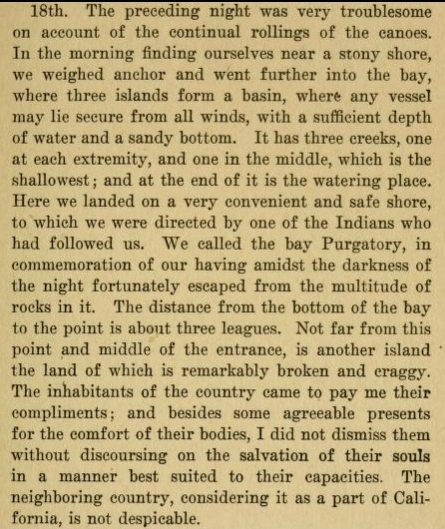
Padre Consag visited Las Animas on day 10 of his journey in 1746.
June 18, 1746
He called the bay Bahia Purgatorio
Harald Pietschmann
|
|
|
JZ
Select Nomad
Posts: 14761
Registered: 10-3-2003
Member Is Offline
|
|
How far up from that beach can you drive? I want to see the beach where the Ecolodge is. I'm taking my Zodiac.

|
|
|
4x4abc
Ultra Nomad
Posts: 4455
Registered: 4-24-2009
Location: La Paz, BCS
Member Is Offline
Mood: happy - always
|
|
with a good 4x4 I have driven to this rocky beach:
28°52'36.14"N 113°22'2.82"W
you only have to make it over this rocky hill:
28°51'55.77"N 113°22'18.85"W
not difficult
Harald Pietschmann
|
|
|
4x4abc
Ultra Nomad
Posts: 4455
Registered: 4-24-2009
Location: La Paz, BCS
Member Is Offline
Mood: happy - always
|
|
cool canyons to explore here:
28°44'20.00"N 113°16'34.01"W
easy drive up the wash
very colorful rock formations
hand size crystals
from there you can continue south to meet up with the main road
followed an old dozer track some years ago
beautiful country
need to be brave and have good 4x4
Attachment: track.kmz (1kB)
This file has been downloaded 289 times
Harald Pietschmann
|
|
|
JZ
Select Nomad
Posts: 14761
Registered: 10-3-2003
Member Is Offline
|
|
| Quote: Originally posted by 4x4abc | with a good 4x4 I have driven to this rocky beach:
28°52'36.14"N 113°22'2.82"W
you only have to make it over this rocky hill:
28°51'55.77"N 113°22'18.85"W
not difficult |
Did you just go down the beach, then over the hill?
|
|
|
4x4abc
Ultra Nomad
Posts: 4455
Registered: 4-24-2009
Location: La Paz, BCS
Member Is Offline
Mood: happy - always
|
|
here is a shortcut for canyon San Pedro I have done some years ago
sparse vegetation - a lot of sand
good for pictures
Attachment: shortcut.kmz (2kB)
This file has been downloaded 295 times
Harald Pietschmann
|
|
|
ehall
Super Nomad
Posts: 1906
Registered: 3-29-2014
Location: Buckeye, Az
Member Is Offline
Mood: It's 5 o'clock somewhere
|
|
| Quote: Originally posted by JZ |
Give us some good trails to ponder Ed.
I wish I had more to share. I got a lot of catching up to do. Lots of places mentioned here that I have never been.
|
|
|
|
4x4abc
Ultra Nomad
Posts: 4455
Registered: 4-24-2009
Location: La Paz, BCS
Member Is Offline
Mood: happy - always
|
|
yup
Harald Pietschmann
|
|
|
David K
Honored Nomad
Posts: 65550
Registered: 8-30-2002
Location: San Diego County
Member Is Offline
Mood: Have Baja Fever
|
|
| Quote: Originally posted by 4x4abc | here is a shortcut for canyon San Pedro I have done some years ago
sparse vegetation - a lot of sand
good for pictures |
Very interesting... I do not see any sign of a track along your line. What do you know of this route? Was it your creation or was there an old path,
perhaps from the mining era?
I am interested in this area because it was in my search region looking for the lost Jesuit ruins of Santa María Magdalena (found by Bahía las
Animas in 1966 and again in 2009) and how Erle Stanley Gardner (1966) and Arthur North (1906) explored that way following the Jesuit's Golfo Camino
Real.
|
|
|
David K
Honored Nomad
Posts: 65550
Registered: 8-30-2002
Location: San Diego County
Member Is Offline
Mood: Have Baja Fever
|
|
| Quote: Originally posted by 4x4abc | Padre Consag visited Las Animas on day 10 of his journey in 1746.
June 18, 1746
He called the bay Bahia Purgatorio |
Consag's 1746 expedition diary (in English) and other trips are in this book, online: https://archive.org/stream/lifeworksofrever00kons#mode/2up
The entire map he made is not copied on that book link, just the southern half.
Here is the whole map...

In another version, made in 1748, a close up of the L.A. Bay region...
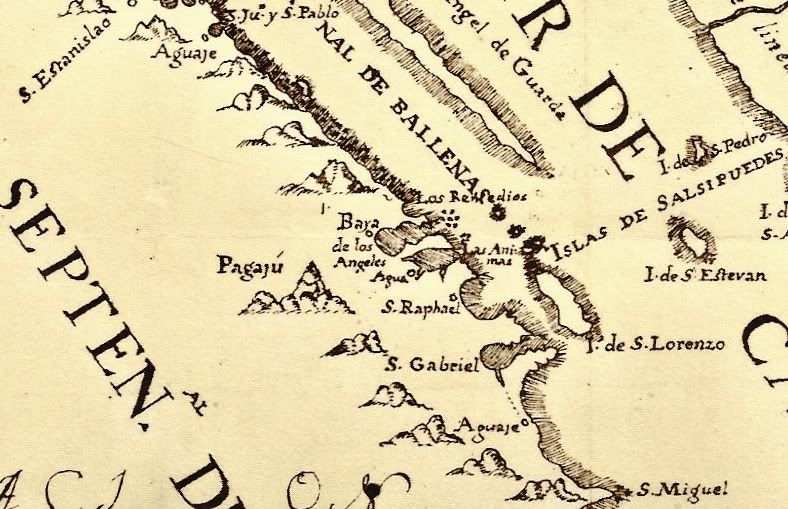
In his diary, he does refer to the location as "Las Animas" (a couple of pages later) and the point he called Cape Las Animas. I think he used the
term Purgatory as a nickname because of their arriving in the dark and surviving the rocks... read below...
It was this canoe expedition that finally put to rest the idea that California was an island (despite it being proven so, many times before)...
|
|
|
PaulW
Ultra Nomad
Posts: 3113
Registered: 5-21-2013
Member Is Offline
|
|
San Pedro with other tracks
SanPedro/Greendoor with Harald's shortcut with a crude track of the main road are shown on the image.
Of course the shortcut is - make your own track in the sand and is a major shortcut from the main road. For people heading south lots of time would be
saved compared to the main road shown in green. Like Harald said - deep sand so be prepared.
However for a bike or 4x4 guy the shortcut misses some of the best and most difficult part of San Pedro drainage.
I am waiting for a report for someone taking that shortcut.

[Edited on 8-29-2019 by PaulW]
|
|
|
larryC
Super Nomad
Posts: 1499
Registered: 8-11-2008
Location: BoLA
Member Is Offline
|
|
Paul
Not sure I understand, is the shortcut you are referring to the blue mark? Back in the old days, before '83 the red mark was the main road. Since the
road was graded and goes through San Rafael it is used very little. Probably only by people like ourselves that just want to do it because we can. I'm
heading down to my place in early Oct and will plan that trip for Nov or Dec. If anybody else wants to join me you are welcome to come along. I'll be
taking my SxS.
Off grid, 12-190 watt evergreen solar panels on solar trackers, 2-3648 stacked Outback inverters, 610ah LiFePo4 48v battery bank, FM 60 and MX60
Outback charge controllers, X-240 Outback transformer for 240v from inverters, 6500 watt Kubota diesel generator.
|
|
|
David K
Honored Nomad
Posts: 65550
Registered: 8-30-2002
Location: San Diego County
Member Is Offline
Mood: Have Baja Fever
|
|
Larry, the blue line is from Harald (4x4abc)... the link was in his post above. I do not understand why he calls it a shortcut to San Pedro Canyon,
however. It bypasses the entrance to the canyon of Arroyo San Pedro (Rancho La Bocana)...
| Quote: Originally posted by 4x4abc | here is a shortcut for canyon San Pedro I have done some years ago
sparse vegetation - a lot of sand
good for pictures |
|
|
|
4x4abc
Ultra Nomad
Posts: 4455
Registered: 4-24-2009
Location: La Paz, BCS
Member Is Offline
Mood: happy - always
|
|
this is the original layout of the old road
Attachment: 4x4 rural .kmz (5kB)
This file has been downloaded 313 times
Harald Pietschmann
|
|
|
larryC
Super Nomad
Posts: 1499
Registered: 8-11-2008
Location: BoLA
Member Is Offline
|
|
I have never noticed any tracks that would take you around San Pedro and I guess on how long ago he did it Odile may have washed out all his old
tracks. The arroyo up past the rancho at San Pedro/La Bocana is worth doing. About 5 miles or so up the wash there is an old mining site with the rock
crusher still there and an old single cylinder 2 cycle engine that through a long belt drove the crusher. I never have found the site where they were
getting the ore to crush but I suspect it was near by. There is also an old ranch cabin not too far from the mining site. Lots of interesting stuff up
in the hills around Bahia.
Harald
My google earth on this computer is messed up so I can't see your kmz files. I guess maybe I need to down load GE again.
[Edited on 8-30-2019 by larryC]
Off grid, 12-190 watt evergreen solar panels on solar trackers, 2-3648 stacked Outback inverters, 610ah LiFePo4 48v battery bank, FM 60 and MX60
Outback charge controllers, X-240 Outback transformer for 240v from inverters, 6500 watt Kubota diesel generator.
|
|
|
David K
Honored Nomad
Posts: 65550
Registered: 8-30-2002
Location: San Diego County
Member Is Offline
Mood: Have Baja Fever
|
|
Harald's latest map shows just the part of the old road from near La Bocana (San Pedro on Almanac) east to the intersection with the graded road.
|
|
|
4x4abc
Ultra Nomad
Posts: 4455
Registered: 4-24-2009
Location: La Paz, BCS
Member Is Offline
Mood: happy - always
|
|
yes, there is a mining trail going in opposite from Rancho San Pedro
Attachment: 4x4 rural mining.kmz (2kB)
This file has been downloaded 246 times
Harald Pietschmann
|
|
|
| Pages:
1
2
3
4
5
6 |


