| Pages:
1
..
46
47
48
49
50
..
116 |
TMW
Select Nomad
      
Posts: 10659
Registered: 9-1-2003
Location: Bakersfield, CA
Member Is Offline
|
|
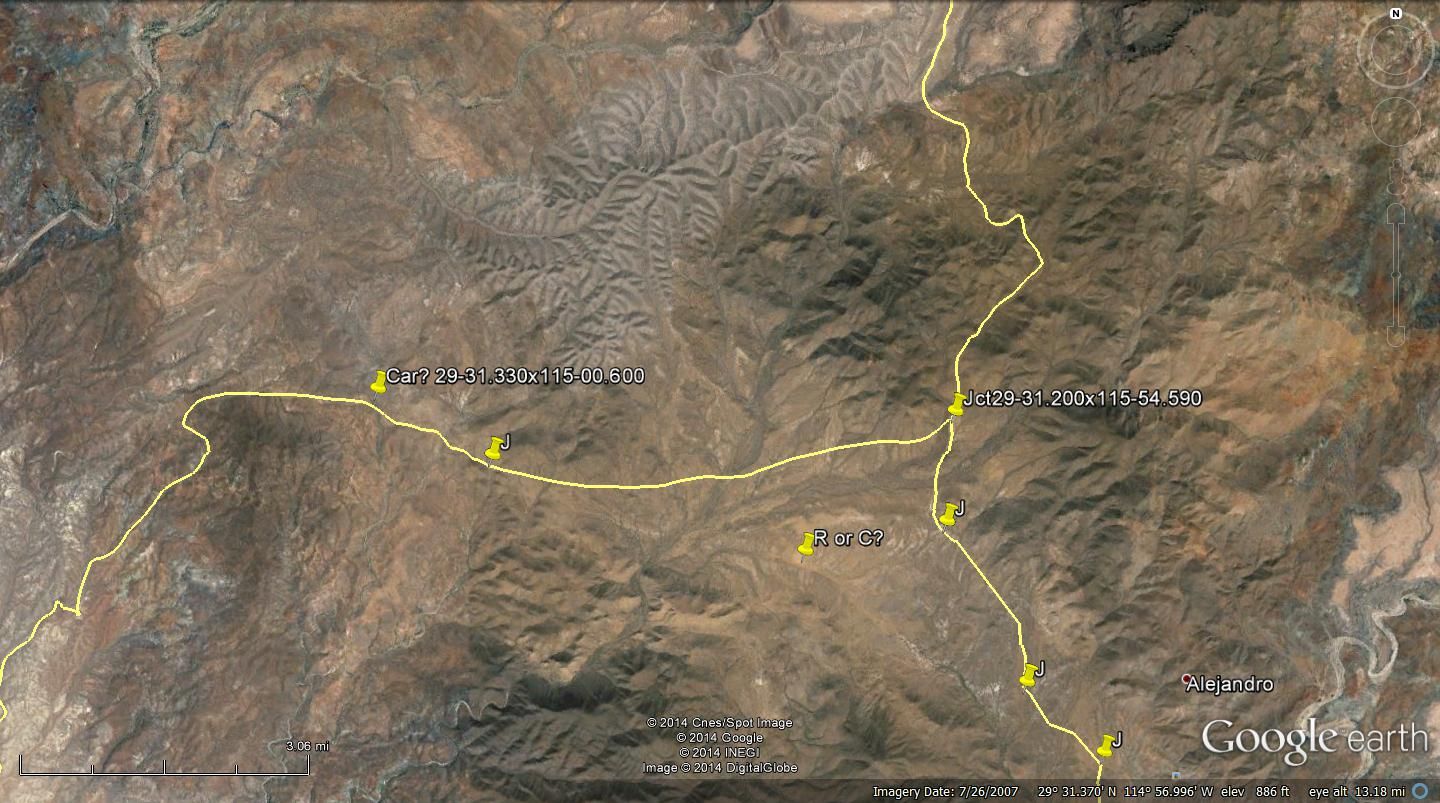
Here is a GE map with the closest location of where the car could have been. It appears to be the only arroyo 10km or 6 miles from the main rd.

|
|
|
woody with a view
PITA Nomad
      
Posts: 15940
Registered: 11-8-2004
Location: Looking at the Coronado Islands
Member Is Offline
Mood: Everchangin'
|
|
I guess it's possible he got lost at night but anyone with 1/2 a brain would realize the sun rises in the east and could find his way from there.
something smells.....
|
|
|
TMW
Select Nomad
      
Posts: 10659
Registered: 9-1-2003
Location: Bakersfield, CA
Member Is Offline
|
|
I would guess he may have pulled in there to sleep and got stuck trying to leave or someone stole his car and put it there. He was probably in the
Canoas area or the San Jose area, since he is a surfer. Showing his picrure in those areas may lead to something. There are also many homes along the
coast in the area. San Jose at the coast is a little community. I have not been to Punta Canoas or Puerto Canoas in years.
|
|
|
DENNIS
Platinum Nomad
       
Posts: 29510
Registered: 9-2-2006
Location: Punta Banda
Member Is Offline
|
|
| Quote: | Originally posted by TW
I would guess he may have pulled in there to sleep and got stuck trying to leave or someone stole his car and put it there. |
I think it was said his valuables were still in the car. If the car had been stolen, one would think everything of value would be gone.
??????????????????????????????????????????????
"YOU CAN'T LITTER ALUMINUM"
|
|
|
TMW
Select Nomad
      
Posts: 10659
Registered: 9-1-2003
Location: Bakersfield, CA
Member Is Offline
|
|
You're right I forgot about that.
|
|
|
willardguy
Elite Nomad
     
Posts: 6451
Registered: 9-19-2009
Member Is Offline
|
|
okay one more time, if he had been out to the coast, it was loong time after he went missing. the same week the family reported him missing we were
between punta canoas and santo domingo. huge rains had left the area between punta canoas down to punta maria a giant mud bog with standing water so
deep many of the beach areas were totally inaccessible. the guys at the fish camp (who had just dug out a new 4wd chevy truck that was buried up to
the door handles) told us the road out to catavina was impassible.
gary's car was only dusty, he hadn't been out there, in that time frame.
|
|
|
EnsenadaDr
Banned
Posts: 5027
Registered: 9-12-2011
Location: Baja California
Member Is Offline
Mood: Move on. It is just a chapter in the past, but don't close the book- just turn the page
|
|
You guys are doing a tremendous job. By golly, we'll find Gary I'm sure of it with the concerted effort.
|
|
|
Taco de Baja
Super Nomad
   
Posts: 1913
Registered: 4-14-2004
Location: Behind the Orange Curtain, CA
Member Is Offline
Mood: Dreamin' of Baja
|
|
| Quote: | Originally posted by PaulW
I was interested in the area. My guess the stuck vehicle was less than 5 km from the coast by various tracks. I found the road off hwy 1 and followed
to an area where it becomes less visible. So I marked various roads in the vicinity. I also made a mark with coords to allow one to get started on GE
near the coast. I suspect that place it where arroyo Mujeres hits the coast? To find Cativina zoom GE and look for Santa Ynez.
Search GE and see what you come up with
Paul |
I’m thinking the "turn to the right" and head on the road to Canoas may be wrong.
If you continue straight from this junction, you will come to the green cement building that is used as a meeting hall/church/salon in approx. ~4.3
miles, turn right here (head south) here and go 1.7 miles and there is a nice sandy wash I have camped in. As I have mentioned before there are not a
lot of nice camping areas on the drive to the coast, and if you see one you take it, especially if it is getting dark. This spot is well hidden if you
go up or down far enough.
This spot is around 14 driving miles to the coast at San Jose, and around 2 hours driving time off the pavement.
If you do the math, this spot also happens to be 6 miles (or 10 KM) from when they said to “turn right.” Just a thought. I may be wrong but I wanted
to add my 2 pesos.
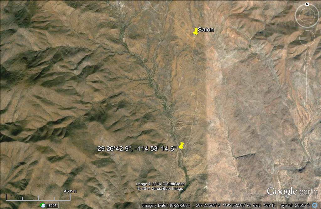
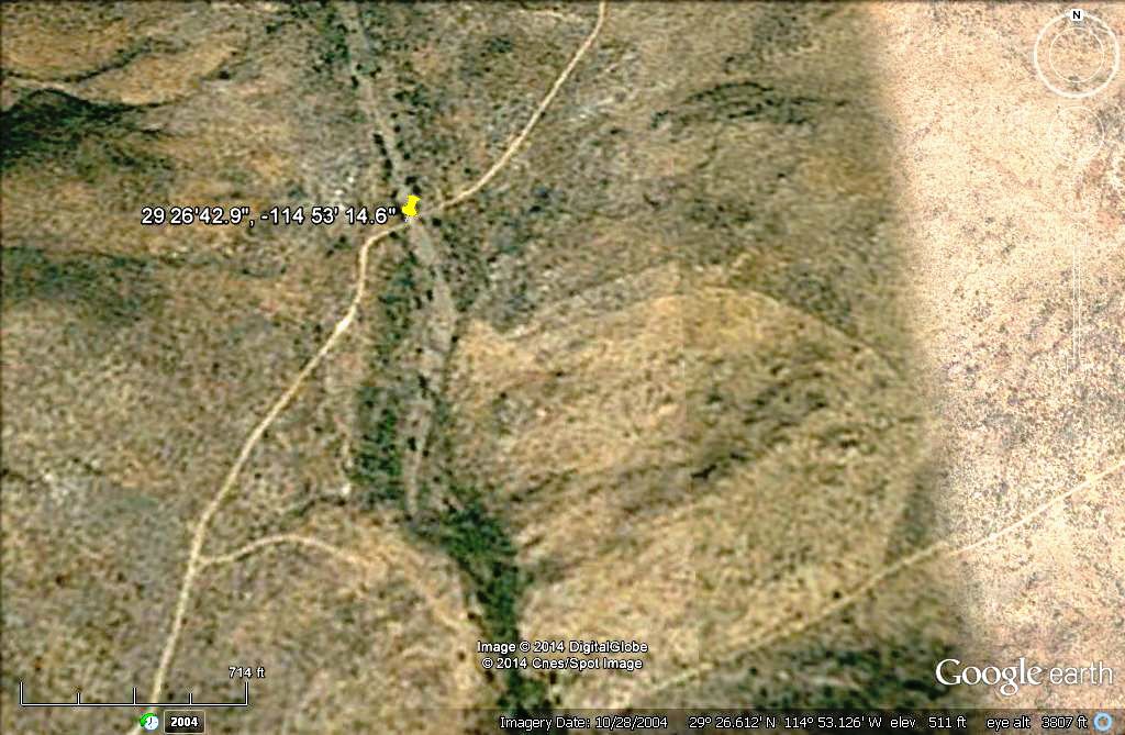
The coordinates are 29 26'42.9" 114 53' 14.6" If anyone is interested in posting a GE image.
Truth generally lies in the coordination of antagonistic opinions
-Herbert Spencer
|
|
|
BajaLuna
Senior Nomad
  
Posts: 581
Registered: 12-5-2012
Location: Pacific Northwest/Bahia Asuncion
Member Is Offline
Mood: groovy
|
|
You're awesome, DavidK!!
|
|
|
DENNIS
Platinum Nomad
       
Posts: 29510
Registered: 9-2-2006
Location: Punta Banda
Member Is Offline
|
|
| Quote: | Originally posted by BajaLuna
You're awesome, DavidK!! |
Yeah...he hasn't been working very much lately and has put on a few kilos.  
jes kiddin' wicha, Big D.
"YOU CAN'T LITTER ALUMINUM"
|
|
|
David K
Honored Nomad
        
Posts: 65428
Registered: 8-30-2002
Location: San Diego County
Member Is Offline
Mood: Have Baja Fever
|
|
One option is he traveled from Baja Jardines (San Quintin) on Hwy. 1 to the Faro San Jose road then headed west... Rather than he was driving the
coast road from Santa Catarina to Santa Rosalillita. It was a 2WD 4Runner, correct? If he never arrived at the coastal fishing camps, then that
explains why nobody saw him.
Good job with the GE map TW!
|
|
|
Mexitron
Ultra Nomad
    
Posts: 3397
Registered: 9-21-2003
Location: Fort Worth, Texas
Member Is Offline
Mood: Happy!
|
|
| Quote: | Originally posted by Taco de Baja
| Quote: | Originally posted by PaulW
I was interested in the area. My guess the stuck vehicle was less than 5 km from the coast by various tracks. I found the road off hwy 1 and followed
to an area where it becomes less visible. So I marked various roads in the vicinity. I also made a mark with coords to allow one to get started on GE
near the coast. I suspect that place it where arroyo Mujeres hits the coast? To find Cativina zoom GE and look for Santa Ynez.
Search GE and see what you come up with
Paul |
I’m thinking the "turn to the right" and head on the road to Canoas may be wrong.
If you continue straight from this junction, you will come to the green cement building that is used as a meeting hall/church/salon in approx. ~4.3
miles, turn right here (head south) here and go 1.7 miles and there is a nice sandy wash I have camped in. As I have mentioned before there are not a
lot of nice camping areas on the drive to the coast, and if you see one you take it, especially if it is getting dark. This spot is well hidden if you
go up or down far enough.
This spot is around 14 driving miles to the coast at San Jose, and around 2 hours driving time off the pavement.
If you do the math, this spot also happens to be 6 miles (or 10 KM) from when they said to “turn right.” Just a thought. I may be wrong but I wanted
to add my 2 pesos.
The coordinates are 29 26'42.9" 114 53' 14.6" If anyone is interested in posting a GE image. |
But if he had gone on the Canoas fork he would have been in the Lazaro drainage which, at least downstream, is a huge sandy wash.
|
|
|
David K
Honored Nomad
        
Posts: 65428
Registered: 8-30-2002
Location: San Diego County
Member Is Offline
Mood: Have Baja Fever
|
|
| Quote: | Originally posted by Taco de Baja
| Quote: | Originally posted by PaulW
I was interested in the area. My guess the stuck vehicle was less than 5 km from the coast by various tracks. I found the road off hwy 1 and followed
to an area where it becomes less visible. So I marked various roads in the vicinity. I also made a mark with coords to allow one to get started on GE
near the coast. I suspect that place it where arroyo Mujeres hits the coast? To find Cativina zoom GE and look for Santa Ynez.
Search GE and see what you come up with
Paul |
I’m thinking the "turn to the right" and head on the road to Canoas may be wrong.
If you continue straight from this junction, you will come to the green cement building that is used as a meeting hall/church/salon in approx. ~4.3
miles, turn right here (head south) here and go 1.7 miles and there is a nice sandy wash I have camped in. As I have mentioned before there are not a
lot of nice camping areas on the drive to the coast, and if you see one you take it, especially if it is getting dark. This spot is well hidden if you
go up or down far enough.
This spot is around 14 driving miles to the coast at San Jose, and around 2 hours driving time off the pavement.
If you do the math, this spot also happens to be 6 miles (or 10 KM) from when they said to “turn right.” Just a thought. I may be wrong but I wanted
to add my 2 pesos.
The coordinates are 29 26'42.9" 114 53' 14.6" If anyone is interested in posting a GE image. |
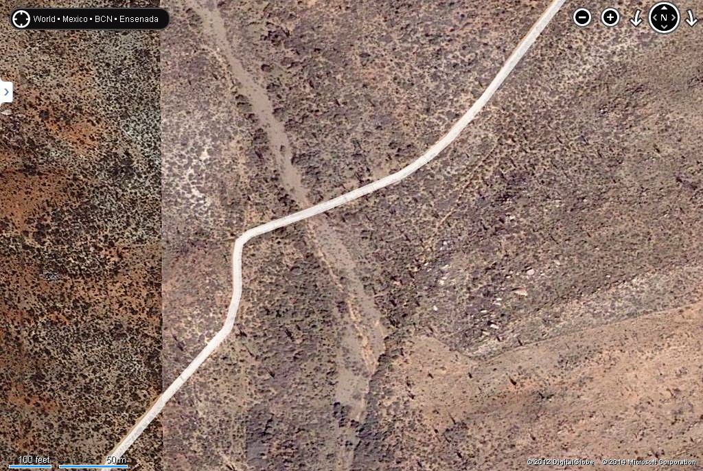
Taco de Baja's GPS on GE and Bing:
GE high to low:


Even closer with Bing:

|
|
|
EnsenadaDr
Banned
Posts: 5027
Registered: 9-12-2011
Location: Baja California
Member Is Offline
Mood: Move on. It is just a chapter in the past, but don't close the book- just turn the page
|
|
If we had the Nomads in charge of the Malaysian Jet mystery it would have been solved long ago!!
|
|
|
PaulW
Ultra Nomad
    
Posts: 3113
Registered: 5-21-2013
Member Is Offline
|
|
You guys are correct I assumed without measuring the vehicle was closer to the coast.
Measuring the roads I now I find I need better directions & distances
Going Rt there are 2 washes. Going Left again 2.
Even with exact coords of the vehicle the search area will be huge.
Even a good tracker will fail after all this time. What is needed to find the remains would be lots of searchers all taking different logical paths.
Whoever goes better take lots of Bing and GE images in a laptop so real time views can make some sense in the field. Hard copy of the images would be
required for each party taking their route.Several of the guys here in SF have the laptop capability in their Jeeps.
For now, I give up.
PW
|
|
|
woody with a view
PITA Nomad
      
Posts: 15940
Registered: 11-8-2004
Location: Looking at the Coronado Islands
Member Is Offline
Mood: Everchangin'
|
|
| Quote: | Originally posted by EnsenadaDr
If we had the Nomads in charge of the Malaysian Jet mystery it would have been solved long ago!! |
or Tattoo, from Fantasy Island! he'd find it....
|
|
|
EnsenadaDr
Banned
Posts: 5027
Registered: 9-12-2011
Location: Baja California
Member Is Offline
Mood: Move on. It is just a chapter in the past, but don't close the book- just turn the page
|
|
that search is gonna end up like Amelia Earhart one of the great unsolved mysteries of aviation history. | Quote: | Originally posted by woody with a view
| Quote: | Originally posted by EnsenadaDr
If we had the Nomads in charge of the Malaysian Jet mystery it would have been solved long ago!! |
or Tattoo, from Fantasy Island! he'd find it.... |
|
|
|
PaulW
Ultra Nomad
    
Posts: 3113
Registered: 5-21-2013
Member Is Offline
|
|
There is a search & rescue org in San Felipe called CERT Community Emergency Response Team
If the family want to contact them go to https://www.facebook.com/CertSanFelipeBc?ref=stream
Paul
|
|
|
BajaBlanca
Select Nomad
      
Posts: 13247
Registered: 10-28-2008
Location: La Bocana, BCS
Member Is Offline
|
|
It would be nice if we had an exact location where the car was. We could take it from there, right?
|
|
|
Marla Daily
Nomad
 
Posts: 418
Registered: 9-2-2003
Location: Loreto, BCS
Member Is Offline
|
|
I'm sure it wouldn't be hard to find the local vaquero who found the car. Anyone within miles will know about it.
|
|
|
| Pages:
1
..
46
47
48
49
50
..
116 |

