| Pages:
1
..
3
4
5
6 |
PaulW
Ultra Nomad

Posts: 3113
Registered: 5-21-2013
Member Is Offline
|
|
4 roads or tracks
Here are 4 roads. Green is the present main road. Red is the track called Green Door or San Pedro. Blue is Harald's sand shortcut. Violet is Harald's
"original layout of the old road".

|
|
|
David K
Honored Nomad
Posts: 65550
Registered: 8-30-2002
Location: San Diego County
Member Is Offline
Mood: Have Baja Fever
|
|
FYI, the Tinaja de Santa María, just 1/2 mile off the Golfo Camino Real, is just south of Valle La Bocana, here: 28° 26.065'N, 113° 20.069'W
This was well described by Arthur North on his 1906 expedition for Camp & Camino in Lower California.
|
|
|
4x4abc
Ultra Nomad
Posts: 4455
Registered: 4-24-2009
Location: La Paz, BCS
Member Is Offline
Mood: happy - always
|
|
here are the other ones worth exploring
Attachment: tracks.kmz (12kB)
This file has been downloaded 281 times
Harald Pietschmann
|
|
|
4x4abc
Ultra Nomad
Posts: 4455
Registered: 4-24-2009
Location: La Paz, BCS
Member Is Offline
Mood: happy - always
|
|
Quote: Originally posted by David K  | FYI, the Tinaja de Santa María, just 1/2 mile off the Golfo Camino Real, is just south of Valle La Bocana, here: 28° 26.065'N, 113° 20.069'W
This was well described by Arthur North on his 1906 expedition for Camp & Camino in Lower California. |
beautifully preserved part of Camino Real right there
Attachment: cr min.kmz (2kB)
This file has been downloaded 285 times
Harald Pietschmann
|
|
|
bajaric
Senior Nomad
Posts: 681
Registered: 2-2-2015
Member Is Offline
|
|
The rock crusher in the canyon west of San Pedro / La Bocana ranch was mentioned by Crosby in his Baja Cave Painting book.
|
|
|
4x4abc
Ultra Nomad
Posts: 4455
Registered: 4-24-2009
Location: La Paz, BCS
Member Is Offline
Mood: happy - always
|
|
no pictures?
no maps?
Harald Pietschmann
|
|
|
bajaric
Senior Nomad
Posts: 681
Registered: 2-2-2015
Member Is Offline
|
|
Harold, I am not tech savvy enough to post maps on here, although your kmz files, when I click on them, show up on my Google earth. Thank you! I
have never been to that place and doubt I ever will, small oddball mine in the middle of nowhere, it would be cool to see but with 2WD a little
sketchy I think. How is the foot?
|
|
|
PaulW
Ultra Nomad
Posts: 3113
Registered: 5-21-2013
Member Is Offline
|
|
From the turn on the proper San Pedro track - where the drainage becomes narrow. What we found was huge rocks making driving somewhat dicy. I will
give it a try on my next trip. Should be an easy walk from the 2wd road from the north. BTW, It is in middle of desolate country so be well prepared
with some kind of satellite tracker like we all use.
Bajaric, get a built 4x4 and enjoy these tracks.
|
|
|
larryC
Super Nomad
Posts: 1499
Registered: 8-11-2008
Location: BoLA
Member Is Offline
|
|
I have driven all the way into the mine site a couple of times, twice on my quad and once in my 4x4 truck. Now the rancher at La Bocana has fenced
the arroyo. If he is there when you go through he would probably give permission to go up there.
Off grid, 12-190 watt evergreen solar panels on solar trackers, 2-3648 stacked Outback inverters, 610ah LiFePo4 48v battery bank, FM 60 and MX60
Outback charge controllers, X-240 Outback transformer for 240v from inverters, 6500 watt Kubota diesel generator.
|
|
|
4x4abc
Ultra Nomad
Posts: 4455
Registered: 4-24-2009
Location: La Paz, BCS
Member Is Offline
Mood: happy - always
|
|
| Quote: Originally posted by larryC | | I have driven all the way into the mine site a couple of times, twice on my quad and once in my 4x4 truck. Now the rancher at La Bocana has fenced
the arroyo. If he is there when you go through he would probably give permission to go up there. |
have you done Custa Santa Isabelita?
I abandoned crossing some years ago running out of time
Harald Pietschmann
|
|
|
larryC
Super Nomad
Posts: 1499
Registered: 8-11-2008
Location: BoLA
Member Is Offline
|
|
Not sure where that is. Give me a hint. Keep in mind that my Google earth on this computer doesn't work. So just lat lon doesn't work for me until I
can get GE working.
Off grid, 12-190 watt evergreen solar panels on solar trackers, 2-3648 stacked Outback inverters, 610ah LiFePo4 48v battery bank, FM 60 and MX60
Outback charge controllers, X-240 Outback transformer for 240v from inverters, 6500 watt Kubota diesel generator.
|
|
|
4x4abc
Ultra Nomad
Posts: 4455
Registered: 4-24-2009
Location: La Paz, BCS
Member Is Offline
Mood: happy - always
|
|

Harald Pietschmann
|
|
|
John M
Super Nomad
Posts: 1924
Registered: 9-3-2003
Location: California High Desert
Member Is Offline
|
|
photos from Rancho San Pedro
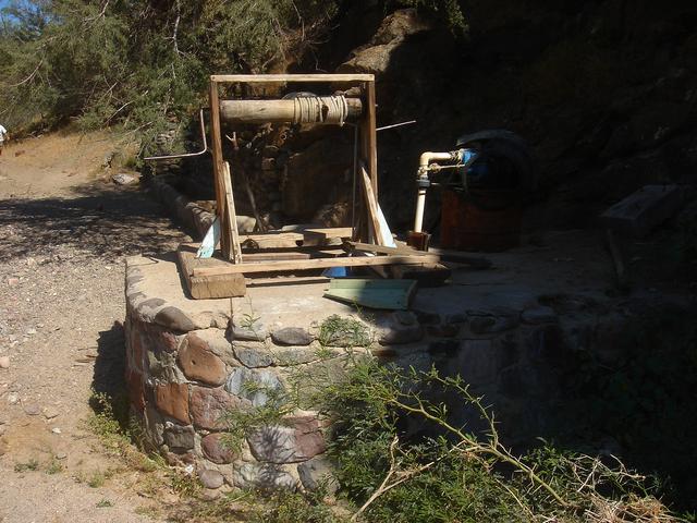
well, looked as though it may still be operative in March 2009
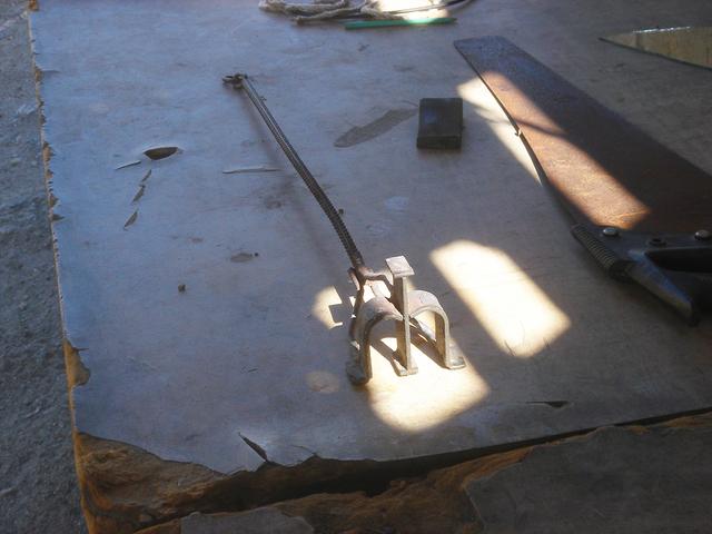
Branding iron remains at the ranch
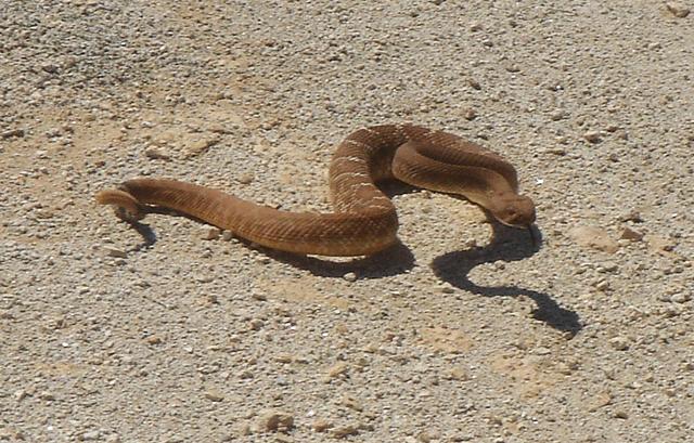
The area around the ranch wasn't completely abandoned
John M
[Edited on 8-31-2019 by John M]
|
|
|
larryC
Super Nomad
Posts: 1499
Registered: 8-11-2008
Location: BoLA
Member Is Offline
|
|
The ranch is seasonal, they run cattle up the arroyo. Lots of water up there. There is also a little rancho half way between the green door turn off
and the La Bocana rancho. I forget the rancheros name but he will take you up in the hills to see the Borregos. He has water holes where the big horn
sheep come in regularly. He also has a little guest room at the ranch where a couple could spend the night. Very basic but would be an adventure.
Oh, by not completely abandoned you meant the snake. I get it.
[Edited on 9-1-2019 by larryC]
Off grid, 12-190 watt evergreen solar panels on solar trackers, 2-3648 stacked Outback inverters, 610ah LiFePo4 48v battery bank, FM 60 and MX60
Outback charge controllers, X-240 Outback transformer for 240v from inverters, 6500 watt Kubota diesel generator.
|
|
|
larryC
Super Nomad
Posts: 1499
Registered: 8-11-2008
Location: BoLA
Member Is Offline
|
|
| Quote: Originally posted by 4x4abc | | Quote: Originally posted by larryC | | I have driven all the way into the mine site a couple of times, twice on my quad and once in my 4x4 truck. Now the rancher at La Bocana has fenced
the arroyo. If he is there when you go through he would probably give permission to go up there. |
have you done Custa Santa Isabelita?
I abandoned crossing some years ago running out of time |
No, not to the extent you have. I have gone through the canyon where the dams are and then come in from the other side of the canyons and also
followed the road out into the hills but I had no idea that you could access the la bocana arroyo from that direction. Would like to do that this
year, looks like an adventure.
Off grid, 12-190 watt evergreen solar panels on solar trackers, 2-3648 stacked Outback inverters, 610ah LiFePo4 48v battery bank, FM 60 and MX60
Outback charge controllers, X-240 Outback transformer for 240v from inverters, 6500 watt Kubota diesel generator.
|
|
|
4x4abc
Ultra Nomad
Posts: 4455
Registered: 4-24-2009
Location: La Paz, BCS
Member Is Offline
Mood: happy - always
|
|
| Quote: Originally posted by larryC |
No, not to the extent you have. I have gone through the canyon where the dams are and then come in from the other side of the canyons and also
followed the road out into the hills but I had no idea that you could access the la bocana arroyo from that direction. Would like to do that this
year, looks like an adventure. |
the padres used it on the way to San Borja
later someone bulldozed a road in
Harald Pietschmann
|
|
|
4x4abc
Ultra Nomad
Posts: 4455
Registered: 4-24-2009
Location: La Paz, BCS
Member Is Offline
Mood: happy - always
|
|
| Quote: Originally posted by larryC | The ranch is seasonal, they run cattle up the arroyo. Lots of water up there. There is also a little rancho half way between the green door turn off
and the La Bocana rancho. I forget the rancheros name but he will take you up in the hills to see the Borregos. He has water holes where the big horn
sheep come in regularly. He also has a little guest room at the ranch where a couple could spend the night. Very basic but would be an adventure.
Oh, by not completely abandoned you meant the snake. I get it.
[Edited on 9-1-2019 by larryC] |
there are 2 ranchos - one of them is called Los Paredones
but I don't know which one
the one on the narrow canyon is Las Venecas
Attachment: rancho Los Paredones.kmz (829B)
This file has been downloaded 272 times
Attachment: rancho Los Paredones II.kmz (752B)
This file has been downloaded 238 times
Attachment: Las Venecas site.kmz (743B)
This file has been downloaded 243 times
Harald Pietschmann
|
|
|
David K
Honored Nomad
Posts: 65550
Registered: 8-30-2002
Location: San Diego County
Member Is Offline
Mood: Have Baja Fever
|
|
Los Paredones was Jesus Flores' ranch. He was made famous in Erle Stanley Gardner's books as having a Lost Gold Mine. I hired him in 2001 to guide us
to what I hoped was the lost mission ruins. Site of Paredones, Jesus' ranch: N28°36.81' W113°24.59'
In 2002, I had him autograph my copy of Gardner's book he is featured in:
http://www.vivabaja.com/402/page6.html
|
|
|
4x4abc
Ultra Nomad
Posts: 4455
Registered: 4-24-2009
Location: La Paz, BCS
Member Is Offline
Mood: happy - always
|
|
looks like they abandoned that site and moved to the south location
Harald Pietschmann
|
|
|
David K
Honored Nomad
Posts: 65550
Registered: 8-30-2002
Location: San Diego County
Member Is Offline
Mood: Have Baja Fever
|
|
Harald, the first Paredones KMZ is the original one. The one you call Paredones II, I do not know about. It wasn't there in 2002, my last time on that
entire road.
Las Venecas is correct. Papa Diaz (L.A. Bay) built a dam in there way way back in time.
|
|
|
| Pages:
1
..
3
4
5
6 |


