| Pages:
1
..
5
6
7
8
9 |
BajaGeoff
Super Nomad
   
Posts: 1727
Registered: 1-11-2006
Location: San Diego and Campo Lopez
Member Is Offline
Mood: Heading To Baja!!!
|
|
DK and I have already been talking about putting another search mission together. We have some additional resources to bring to the table that will
help...updates to follow as we make some progress on the planning!
|
|
|
David K
Honored Nomad
        
Posts: 65453
Registered: 8-30-2002
Location: San Diego County
Member Is Offline
Mood: Have Baja Fever
|
|
Quote: Originally posted by Fatboy  | | DK....What was your criteria for the current search site? How did you narrow it to the current area? |
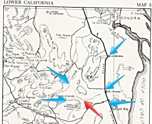
Did you read the letter earlier in this thread? The following map points out places in the letter...
Based on the rock pile's discoverer, Walter Henderson... as told to Choral Pepper in 1967 (and she turned into a mystery story in her book and
magazine articles):
As you can read Walters letter, I shared publically here on Baja Nomad for all to enjoy and help figure out where the rock pile was...
Mentioned and pointed out, on the 1962 Lower Ca Guidebook Map 3: Remember, there was no Hwy. 5 back then, the old road to San Felipe may have been
close, however.
*La Ventana
*Road running west from just north of El Chinero, about 20 miles south of La Ventana.
* Take off about 5 miles below road north of El Chinero
* RED ARROW: Parked at Base of hills
* Arroyo Grande
* Base of Cerro Borrego
[Edited on 7-15-2015 by David K]
|
|
|
Fatboy
Senior Nomad
  
Posts: 805
Registered: 6-28-2005
Member Is Offline
|
|
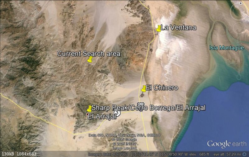
Do I have your general search area marked correctly?
|
|
|
David K
Honored Nomad
        
Posts: 65453
Registered: 8-30-2002
Location: San Diego County
Member Is Offline
Mood: Have Baja Fever
|
|
Quote: Originally posted by PaulW  | David can you resurrect an overview showing the A, B, C locations in the AG wash?
I know we saw it back when with coordinates at one time.
Thanks |
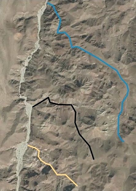
Hi Paul, Arroyo C was dismissed before this year's discussion, but it is at or close to where you parked your truck and hiked into Arroyo B's middle
valley from (ie. the top right of this map that shows Arroyos B, A, and D from top to bottom):
|
|
|
David K
Honored Nomad
        
Posts: 65453
Registered: 8-30-2002
Location: San Diego County
Member Is Offline
Mood: Have Baja Fever
|
|
Your pin 'current search area' is approx. where Arroyo B meets Arroyo Grande.
I appreciate your interest in helping us find the rock pile!
Did you read the Baja Bound article last month?: http://www.bajabound.com/bajaadventures/bajatravel/searching...
|
|
|
Fatboy
Senior Nomad
  
Posts: 805
Registered: 6-28-2005
Member Is Offline
|
|
Same story...reading it now...but am unsure where the comments such as these ....
They reached the top of the Sierra Pinta range and then went steeply down the west side, into Arroyo Grande. Around noon, roughly 1/4 to 1/3 of the
distance down from the divide
and this.....
They made camp that night in Arroyo Grande, and returned the next day to the Model A by traveling up Arroyo Grande to the base of Borrego Mountain and
then back east to the car
The camping part - no problem - but the rest?
Are these based on other letters or notes or by a careful reading of the letters you posted?
|
|
|
David K
Honored Nomad
        
Posts: 65453
Registered: 8-30-2002
Location: San Diego County
Member Is Offline
Mood: Have Baja Fever
|
|
Quote: Originally posted by Fatboy  | Same story...reading it now...but am unsure where the comments such as these ....
They reached the top of the Sierra Pinta range and then went steeply down the west side, into Arroyo Grande. Around noon, roughly 1/4 to 1/3 of the
distance down from the divide
and this.....
They made camp that night in Arroyo Grande, and returned the next day to the Model A by traveling up Arroyo Grande to the base of Borrego Mountain and
then back east to the car
The camping part - no problem - but the rest?
Are these based on other letters or notes or by a careful reading of the letters you posted?
|
The entire letter and the additional direction page is posted in this thread. I did so in hopes others will find clues I may have missed.
I posted my best guess after reading the letter for the past 12 years multiple times. I would like (as would have Choral) to find the rock pile in my
lifetime. I think it would be more successful to involve my Nomad friends. It was with thier (your) help I could visit the rock walls that Choral saw
in 1966, and she later believed was a Jesuit proposed mission site... but could not find it again.
Thank you for your interest!
|
|
|
PaulW
Ultra Nomad
    
Posts: 3113
Registered: 5-21-2013
Member Is Offline
|
|
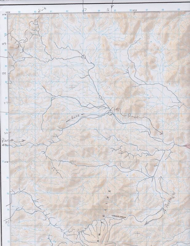
Beginning at the Model A
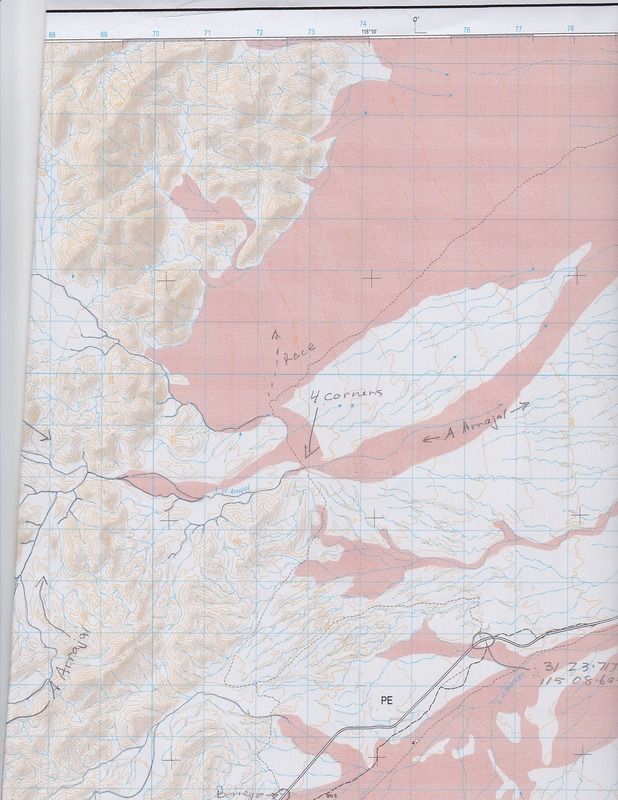
We now know Henderson parked his Model A near 4 corners then walked west. Then my hypothesis is the easy walking would be one of the two drainages
looking west. The one leading NW ends quickly after heading N. Lots of choices for sure.
The other one is Arroyo Arrajal which leads pretty much the same way but then turns SW. But there is another drainage that heads NW then W toward the
heart of Arroyo Grande.
So my next project will be two fold.
1) Climb to the top of Arrajal and have a look. Who knows if I will make any conclusions from the top? I will tell you all about the results later.
For now the preliminary plan is to start at the Slate Mine and take the NE leading ridge. My link about Slate is http://forums.bajanomad.com/viewthread.php?tid=72246#pid8855...
Note the error in the label of the arroyo
2) Drive as far as I can up the fork off the race track that leads NW Junction is at ~31 26.7, 115 15.9. Then walk around toward AG to have a look
see.
So I will tell you the dates later and invite your participation.
|
|
|
David K
Honored Nomad
        
Posts: 65453
Registered: 8-30-2002
Location: San Diego County
Member Is Offline
Mood: Have Baja Fever
|
|
Wonderful!
Use the hint that Walter gave us, that he was seeking a way to the Sierra las Palmitas and Tinajas, for the rumored blue palms. He knew they were too
far south, but that was the only route they found from the San Felipe road to the base of the small mountains, east of the Sierra Juarez.
That is why I guessed he would have hiked northwest to the divide and not straight west from the Model A. He came back a different route, from the
base of Cerro Borrego, so that I think Arroyo Arrajal was on or parallel to his return route back from Arroyo Grande?
Obviously we will not know any of this for sure until the rock pile is discovered! I wish you luck! I do have a planned return expedition, perhaps
after the heat of September?
|
|
|
BajaGeoff
Super Nomad
   
Posts: 1727
Registered: 1-11-2006
Location: San Diego and Campo Lopez
Member Is Offline
Mood: Heading To Baja!!!
|
|
Excellent Paul!
Keep us posted. I would love to be a part of the next trip out there and I know David would too.
|
|
|
PaulW
Ultra Nomad
    
Posts: 3113
Registered: 5-21-2013
Member Is Offline
|
|
Do you think from 4 corners the arroyo north of Arrajal should be the first choice?
========
Quote: Originally posted by David K  | Wonderful!
Use the hint that Walter gave us, that he was seeking a way to the Sierra las Palmitas and Tinajas, for the rumored blue palms. He knew they were too
far south, but that was the only route they found from the San Felipe road to the base of the small mountains, east of the Sierra Juarez.
That is why I guessed he would have hiked northwest to the divide and not straight west from the Model A. He came back a different route, from the
base of Cerro Borrego, so that I think Arroyo Arrajal was on or parallel to his return route back from Arroyo Grande?
Obviously we will not know any of this for sure until the rock pile is discovered! I wish you luck! I do have a planned return expedition, perhaps
after the heat of September? |
|
|
|
David K
Honored Nomad
        
Posts: 65453
Registered: 8-30-2002
Location: San Diego County
Member Is Offline
Mood: Have Baja Fever
|
|
Quote: Originally posted by PaulW  | Do you think from 4 corners the arroyo north of Arrajal should be the first choice?
========
Quote: Originally posted by David K  | Wonderful!
Use the hint that Walter gave us, that he was seeking a way to the Sierra las Palmitas and Tinajas, for the rumored blue palms. He knew they were too
far south, but that was the only route they found from the San Felipe road to the base of the small mountains, east of the Sierra Juarez.
That is why I guessed he would have hiked northwest to the divide and not straight west from the Model A. He came back a different route, from the
base of Cerro Borrego, so that I think Arroyo Arrajal was on or parallel to his return route back from Arroyo Grande?
Obviously we will not know any of this for sure until the rock pile is discovered! I wish you luck! I do have a planned return expedition, perhaps
after the heat of September? |
|
Yes.
|
|
|
PaulW
Ultra Nomad
    
Posts: 3113
Registered: 5-21-2013
Member Is Offline
|
|
Quote: Originally posted by David K  |
Use the hint that Walter gave us, that he was seeking a way to the Sierra las Palmitas and Tinajas, for the rumored blue palms. He knew they were too
far south, but that was the only route they found from the San Felipe road to the base of the small mountains, east of the Sierra Juarez.
That is why I guessed he would have hiked northwest to the divide and not straight west from the Model A. He came back a different route, from the
base of Cerro Borrego, so that I think Arroyo Arrajal was on or parallel to his return route back from Arroyo Grande?
========
Quote: Originally posted by PaulW  | Do you think from 4 corners the arroyo north of Arrajal should be the first choice?
========
========
I understand your suggestion and will do both. That northerly one quickly merges with the off shoot NW from Race but does not look as drive-able. I
want to drive for a quick look before the hiking begins.
So the dilemma is when ‘does one head west’? My guess would be 31 28-29’?
PS, Other readers need to remember Henderson’s C. Borrego is the present day C. Arrajal? On the new maps C Borrego is closer to Hwy 3. Another easy
hike to get the views south to see Diablo and Lugana Diablo
|
|
|
|
|
David K
Honored Nomad
        
Posts: 65453
Registered: 8-30-2002
Location: San Diego County
Member Is Offline
Mood: Have Baja Fever
|
|
Yes, Henderson's Cerro Borrego is the topo map's Cerro Arrajal. On other old maps it was called 'Sharp Peak', as well.
|
|
|
kevin_in_idaho
Nomad
 
Posts: 143
Registered: 12-13-2016
Member Is Offline
|
|
I googled Walter Henderson and trying to figure out who he was, etc. I see by one of your posts you are looking for a grave site?
This is pretty cool to see how your thought process is going! It'd be cool to find it.
[Edited on 3-21-2017 by kevin_in_idaho]
|
|
|
David K
Honored Nomad
        
Posts: 65453
Registered: 8-30-2002
Location: San Diego County
Member Is Offline
Mood: Have Baja Fever
|
|
Quote: Originally posted by kevin_in_idaho  | I googled Walter Henderson and trying to figure out who he was, etc. I see by one of your posts you are looking for a grave site?
This is pretty cool to see how your thought process is going! It'd be cool to find it.
[Edited on 3-21-2017 by kevin_in_idaho] |
Read this: https://www.bajabound.com/bajaadventures/bajatravel/searchin...
|
|
|
kevin_in_idaho
Nomad
 
Posts: 143
Registered: 12-13-2016
Member Is Offline
|
|
I wish I lived closer as I'd love to help out; can you imagine when you find it how cool that will be!?
|
|
|
fishbuck
Banned
Posts: 5318
Registered: 8-31-2006
Member Is Offline
|
|
That is truely amazing.
"A ship in harbor is safe, but that is not what ships are built for." J. A. Shedd.
A clever person solves a problem. A wise person avoids it. – Albert Einstein
"Life's a Beach... and then you Fly!" Fishbuck
|
|
|
fishbuck
Banned
Posts: 5318
Registered: 8-31-2006
Member Is Offline
|
|
I mean the logistics of this is mind boggling. The resupply effort that Diaz was assigned to. Who planned this all out? Someone in Spain?
[Edited on 5-13-2017 by fishbuck]
"A ship in harbor is safe, but that is not what ships are built for." J. A. Shedd.
A clever person solves a problem. A wise person avoids it. – Albert Einstein
"Life's a Beach... and then you Fly!" Fishbuck
|
|
|
David K
Honored Nomad
        
Posts: 65453
Registered: 8-30-2002
Location: San Diego County
Member Is Offline
Mood: Have Baja Fever
|
|
Read about the Coronado expedition (1540-41) seeking the golden cities of Cibola. Alarcon and Melchior Diaz were part of that expedition... only the
Colorado River did not get them close enough to the main party to resupply them.
Read: https://en.wikipedia.org/wiki/Francisco_V%C3%A1zquez_de_Coro...
|
|
|
| Pages:
1
..
5
6
7
8
9 |

