| Pages:
1
..
5
6
7
8
9
..
18 |
Ken Cooke
Elite Nomad

Posts: 8971
Registered: 2-9-2004
Location: Riverside, CA
Member Is Offline
Mood: Pole Line Road postponed due to injury
|
|
4 hrs = ½ day Jeep trail. I would like that, but the wife will want to rest. Maybe,we could run in the afternoon and people can sightsee and sleep
in.
I will plug that in my agenda Rich T!
What is the name of that trail, again?
|
|
|
rich t
Nomad
Posts: 102
Registered: 4-18-2016
Member Is Offline
|
|
Pioneer Mine Trail
|
|
|
PaulW
Ultra Nomad
Posts: 3113
Registered: 5-21-2013
Member Is Offline
|
|
IMO
The list of difficult rides diving distance from San Felipe. Hardest first.
With the local names
* Huatamote from Parral to L Diablo. (No record of a passage yet).
* Mini Summit Going up Hill (aka power line road summit)
* Mini summit going down hill
* Pioneer Mine road
* Turquesia grade
* Matomi
* Pole line road (stack the rocks and move it down the list)
* The other SF arroyos: Huatamote, Azufre, & Chanate, & Curevitas
(previous recent weather dependent)
* Both the Pinta passes
* San Pedro (aka Green Door)
Add your own choices to the list
[Edited on 8-9-2018 by PaulW]
|
|
|
rich t
Nomad
Posts: 102
Registered: 4-18-2016
Member Is Offline
|
|
Paul, We should run the la turguesa(XR Trail,Freds Tractor Trail) this winter,a local Mexican jeep club ran it earlier this year, I met up with them
at Coco's in April.
|
|
|
PaulW
Ultra Nomad
Posts: 3113
Registered: 5-21-2013
Member Is Offline
|
|
Power line refers to Mini Summit not Pole line.
|
|
|
PaulW
Ultra Nomad
Posts: 3113
Registered: 5-21-2013
Member Is Offline
|
|
Telegraph is improper for all the tracks.
Poleline and Powerline are not the same tracks
I used telegraph because I saw it in print somewhere I should not have repeated it.
|
|
|
David K
Honored Nomad
Posts: 65562
Registered: 8-30-2002
Location: San Diego County
Member Is Offline
Mood: Have Baja Fever
|
|
10-4 Paul... I will just delete my stuff added today. You guys have fun and keep an eye open for history!
|
|
|
PaulW
Ultra Nomad
Posts: 3113
Registered: 5-21-2013
Member Is Offline
|
|
Quote: Originally posted by rich t  | Paul, We should run the la turguesa(XR Trail,Freds Tractor Trail) this winter,a local Mexican jeep club ran it earlier this year, I met up with them
at Coco's in April.
|
=====
Agree it has been on my to do list for years. Went there a long time ago but was voted down by my companions.
|
|
|
Ken Cooke
Elite Nomad
Posts: 8971
Registered: 2-9-2004
Location: Riverside, CA
Member Is Offline
Mood: Pole Line Road postponed due to injury
|
|
| Quote: Originally posted by PaulW | IMO
The list of difficult rides diving distance from San Felipe. Hardest first.
With the local names
* Huatamote from Parral to L Diablo. (No record of a passage yet).
* Mini Summit Going up Hill (aka power line road summit)
* Mini summit going down hill
* Pioneer Mine road
* Turquesia grade
* Matomi
* Pole line road (stack the rocks and move it down the list)
* The other SF arroyos: Huatamote, Azufre, & Chanate, & Curevitas
(previous recent weather dependent)
* Both the Pinta passes
* San Pedro (aka Green Door)
Add your own choices to the list
[Edited on 8-9-2018 by PaulW] |
Thanks for the comprehensive list, Paul.
|
|
|
bajatrailrider
Ultra Nomad
Posts: 2553
Registered: 1-24-2015
Location: Mexico
Member Is Offline
Mood: Happy
|
|
The Xr trail a tuff one on our bikes years ago was not passable by 4 wheeler. With all the SXS going up hopeful it is more easy now. After the
boulders to get to hill climb. That took many runs on the bikes to get over rock pile at bottom climb. 17 or more years ago sounds like best in a
jeep.
|
|
|
Ken Cooke
Elite Nomad
Posts: 8971
Registered: 2-9-2004
Location: Riverside, CA
Member Is Offline
Mood: Pole Line Road postponed due to injury
|
|
| Quote: Originally posted by bajatrailrider | | The Xr trail a tuff one on our bikes years ago was not passable by 4 wheeler. With all the SXS going up hopeful it is more easy now. After the
boulders to get to hill climb. That took many runs on the bikes to get over rock pile at bottom climb. 17 or more years ago sounds like best in a
jeep. |
I drove up La Turquesa near the mine about 10 years ago, but I couldn't find the route to the uphill grade. It was a nice side trip for our group.
|
|
|
rich t
Nomad
Posts: 102
Registered: 4-18-2016
Member Is Offline
|
|
I have done both ends but never the whole trail.
|
|
|
bajatrailrider
Ultra Nomad
Posts: 2553
Registered: 1-24-2015
Location: Mexico
Member Is Offline
Mood: Happy
|
|
Did you go the bottom up turn around go back down. Or stop at start up hill.
|
|
|
David K
Honored Nomad
Posts: 65562
Registered: 8-30-2002
Location: San Diego County
Member Is Offline
Mood: Have Baja Fever
|
|
For what it's worth, here is my observation after finding the top of the grade in February 2007 to 'discover' it was an auto road and not a single
track as I thought Kacey Smith had described it: http://vivabaja.com/207/ (first two pages)
Following that trip, 'steekers' rode in with his m/c and took photos of the grade from the turquoise mine, then Ken and his group tried to get to the
bottom of the grade from the turquoise mine. Finally, with help from TW and others, Roy 'The Squarecircle' in an LR-3 Land Rover made it to the base,
then drove to the top and on the Hwy. 1.
|
|
|
TMW
Select Nomad
Posts: 10659
Registered: 9-1-2003
Location: Bakersfield, CA
Member Is Offline
|
|
I think Roy had more trouble at the bottom of the hill after getting out of the arroyo than the section from the mine to the arroyo exit.
|
|
|
bajatrailrider
Ultra Nomad
Posts: 2553
Registered: 1-24-2015
Location: Mexico
Member Is Offline
Mood: Happy
|
|
Yes the bottom of the hill had large rocks holes very steep angle at bottom. This was years ago Mike was on his TT680 custom framed Yamaha. I was on
my TT680 with Cr500 Susp and Girl on back. She was able to walk faster then we could ride the bikes HAAAA
|
|
|
rich t
Nomad
Posts: 102
Registered: 4-18-2016
Member Is Offline
|
|
We did the part from hwy 5 to the mine in the Jeeps about 7 years ago, last year I took a look at it from hwy 1 looking down, was on a 6 day dirt bike
trip and that was not part of our route but took a look for future rides.
|
|
|
Ken Cooke
Elite Nomad
Posts: 8971
Registered: 2-9-2004
Location: Riverside, CA
Member Is Offline
Mood: Pole Line Road postponed due to injury
|
|
courtesy of Animals4x4 Club, Mexicali


...and on to THE SUMMIT and Laguna Hanson for these hardy 4 wheelers! Muchas gracias por las fotos, Animales 4x4!

|
|
|
Ken Cooke
Elite Nomad
Posts: 8971
Registered: 2-9-2004
Location: Riverside, CA
Member Is Offline
Mood: Pole Line Road postponed due to injury
|
|
Chloe Blair
Chloe Blaire offered to provide THE IMPOSSIBLE participants with a full MATOMI tour!
Chloe Blaire wrote:
"Cinnamon valley is in Matomi Canyon and it has an arch like they have in Utah.. Have you gone all the way in Matomi to the ranch hole, has water
fall and a large pool of water. You can even do dry camping there."
|
|
|
David K
Honored Nomad
Posts: 65562
Registered: 8-30-2002
Location: San Diego County
Member Is Offline
Mood: Have Baja Fever
|
|
| Quote: Originally posted by Ken Cooke | Chloe Blaire offered to provide THE IMPOSSIBLE participants with a full MATOMI tour!
Chloe Blaire wrote:
"Cinnamon valley is in Matomi Canyon and it has an arch like they have in Utah.. Have you gone all the way in Matomi to the ranch hole, has water
fall and a large pool of water. You can even do dry camping there." |
Arroyo Las Blancas, south of Arroyo Matomí:
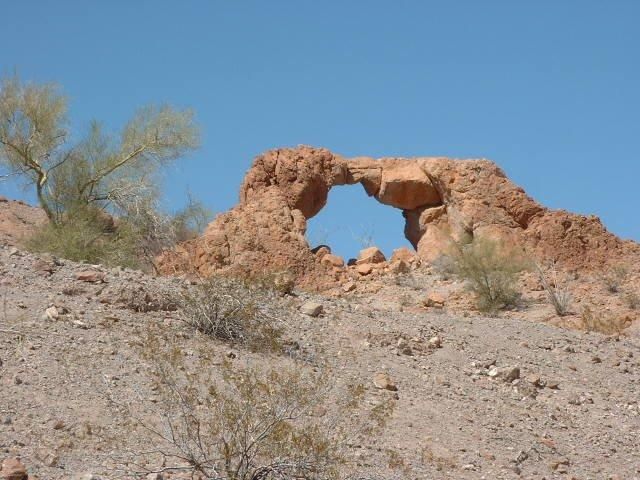
Photo from PaulW... from one of your threads Ken: http://forums.bajanomad.com/viewthread.php?tid=68128
I was going there last March 2017 but the boulders blocking the Narrows of Matomí Canyon prevented that!
|
|
|
| Pages:
1
..
5
6
7
8
9
..
18 |


