| Pages:
1
2
3
4
5
6 |
4x4abc
Ultra Nomad

Posts: 4430
Registered: 4-24-2009
Location: La Paz, BCS
Member Is Offline
Mood: happy - always
|
|
in that area Fe22 to Fe100 is almost certain pure ECR
between 3 and 4ft wide - pretty rough
Harald Pietschmann
|
|
|
David K
Honored Nomad
Posts: 65243
Registered: 8-30-2002
Location: San Diego County
Member Is Offline
Mood: Have Baja Fever
|
|
Quote: Originally posted by cupcake  | | Quote: Originally posted by 4x4abc | | Quote: Originally posted by cupcake | https://filebin.net/fn8b7iovjbgh4hjy
The above link is to the the PDF of my Santa Gertrudis to San Ignacio route, with GPS waypoints moved onto the trail. This link remains active for six
days only.
I have been advised that some of this route is not the original ECR. Harald has sent files to me that contain route variations, which I plan on
incorporating into my map when I can. I imagine if I took a guide / vaquero on this trek, they also might have their own trail variations that they
like to use. |
none of your route is ECR
they are various roads built by the French mining company Boleo around 1910
|
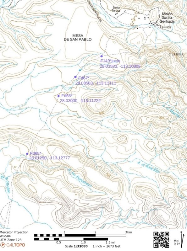
I finally got around to looking at Kevin and Genevieve's website waypoints. From their website: "Many waypoints have a lowercase letter next to the
section letter (i.e., Fd58*). The second letter indicates that this is actually a trail option that is true ECR." These three waypoints: Fd67, Fd66,
Fd65 are denoted as being true ECR and they are all exactly on the route I have marked on my PDF. Then comes Fd64, and here there is a difference, as
my route starts taking a more direct path to Las Juntas.
I plan on spending some time with Kevin and Genevieve's waypoints to see how the true ECR compares with the route I have marked on my PDF. Of most
importance to me, is that K & G's true ECR waypoints with an * (asterisk) are points where the old trail can be seen on the ground or from space.
I definitely want to note these on my map, as I would like to see and stand on this 'sacred ground'.
[Edited on 10-23-2024 by cupcake] |
|
|
|
4x4abc
Ultra Nomad
Posts: 4430
Registered: 4-24-2009
Location: La Paz, BCS
Member Is Offline
Mood: happy - always
|
|
the Pacific route is almost 100% El Boleo
[Edited on 10-24-2024 by 4x4abc]
Harald Pietschmann
|
|
|
cupcake
Nomad
Posts: 380
Registered: 4-23-2024
Member Is Offline
|
|
That surprises me, as every waypoint on K & G's site for the Pacific route in that section denotes original ECR, many or most with an asterisk,
denoting that the old trail is visible on the ground or from space. Am I missing something there? I was going to ask you if that Pacific route is more
aesthetic than the route I have marked up. I was wondering about water sources on that Pacific route. Perhaps it's best I stay with my current marked
route?
|
|
|
cupcake
Nomad
Posts: 380
Registered: 4-23-2024
Member Is Offline
|
|
| Quote: Originally posted by David K | | Quote: Originally posted by cupcake | | Quote: Originally posted by 4x4abc | | Quote: Originally posted by cupcake | https://filebin.net/fn8b7iovjbgh4hjy
The above link is to the the PDF of my Santa Gertrudis to San Ignacio route, with GPS waypoints moved onto the trail. This link remains active for six
days only.
I have been advised that some of this route is not the original ECR. Harald has sent files to me that contain route variations, which I plan on
incorporating into my map when I can. I imagine if I took a guide / vaquero on this trek, they also might have their own trail variations that they
like to use. |
none of your route is ECR
they are various roads built by the French mining company Boleo around 1910
|
I finally got around to looking at Kevin and Genevieve's website waypoints. From their website: "Many waypoints have a lowercase letter next to the
section letter (i.e., Fd58*). The second letter indicates that this is actually a trail option that is true ECR." These three waypoints: Fd67, Fd66,
Fd65 are denoted as being true ECR and they are all exactly on the route I have marked on my PDF. Then comes Fd64, and here there is a difference, as
my route starts taking a more direct path to Las Juntas.
I plan on spending some time with Kevin and Genevieve's waypoints to see how the true ECR compares with the route I have marked on my PDF. Of most
importance to me, is that K & G's true ECR waypoints with an * (asterisk) are points where the old trail can be seen on the ground or from space.
I definitely want to note these on my map, as I would like to see and stand on this 'sacred ground'.
[Edited on 10-23-2024 by cupcake] |
|
Thanks for posting the image, David. This time I reduced the size of the original PDF (the original is crisp and sharp), so that I could try to put it
in a Baja Nomad post. I halved the scale, making the resolution much better when I print the page (I tested one). This about doubles the number of map
sheets, but it is still very manageable.
[Edited on 10-24-2024 by cupcake]
|
|
|
David K
Honored Nomad
Posts: 65243
Registered: 8-30-2002
Location: San Diego County
Member Is Offline
Mood: Have Baja Fever
|
|
Sorry, but I disagree with Harald about the Pacifico ECR. The Visita de San Pablo is on it. West of San Pablo is a Boleo road, going straight to
Prosperidad, a casona (Boleo ranch house) built around 1914.
|
|
|
4x4abc
Ultra Nomad
Posts: 4430
Registered: 4-24-2009
Location: La Paz, BCS
Member Is Offline
Mood: happy - always
|
|
| Quote: Originally posted by David K | | Sorry, but I disagree with Harald about the Pacifico ECR. The Visita de San Pablo is on it. West of San Pablo is a Boleo road, going straight to
Prosperidad, a casona (Boleo ranch house) built around 1914. |
as I wrote before, the El Boleo roads are often following where the ECR used to be
sometimes possibly in the vicinity of ECR
sometimes possibly right on top of it
the way the El Boleo road is built indicates that they were pretty much right on top of ECR as there are many visible sections where ECR continues
where the dozer had stopped
below is one of the many examples I have collected
the narrow dozer track ends and and animal trail (or ECR) continues

Harald Pietschmann
|
|
|
4x4abc
Ultra Nomad
Posts: 4430
Registered: 4-24-2009
Location: La Paz, BCS
Member Is Offline
Mood: happy - always
|
|
here is another good example - the 13ft wide Boleo track ends and a narrow section of ECR continues
Fa5* on Genevieve and Kevin's list

Harald Pietschmann
|
|
|
David K
Honored Nomad
Posts: 65243
Registered: 8-30-2002
Location: San Diego County
Member Is Offline
Mood: Have Baja Fever
|
|
Those are excellent examples!
Correct about ECR never being 13 ft. wide.
I was just commenting on you saying the Pacifico Camino Real (the Jesuit road on the west slope of the Sierra San Francisco) was Boleo made.
I see an edit to that, but still not looking 100% right to me: "the Pacific route is almost 100% El Boleo"
There were two primary 'Pacifico' Camino Reals as much as there were two 'Golfo' Camino Reals... Plus, the Sierra Camino Real... between San Ignacio
and Santa Gertrudis then Santa Gertrudis to San Borja... all three roads were built in the 1750s and 1760s.
We pretty much have the three routes to Santa Gertrudis nailed down, but only the Sierra and Golf routes to San Borja identified.
The Pacifico route to San Borja passed through Visita de San Regis and probably Visita de San Ignacio (today's Rancho San Ignacito, and or Visita de
Santa Ana, west of San Borja). Maybe Harald has spotted the Pacifico route in this section?
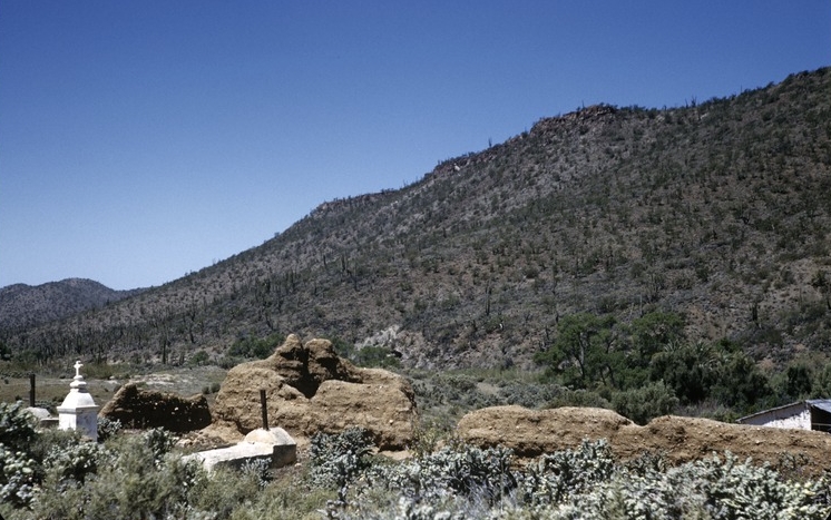
Recent photo of Visita San Regis (2023):

1953 photo (by Howard Gulick):
|
|
|
cupcake
Nomad
Posts: 380
Registered: 4-23-2024
Member Is Offline
|
|
I guess it is not surprising after all, that aficionados might disagree on what is old ECR and what is not.
I have a question regarding GPS coordinates. Kevin & Genevieve's ECR waypoint coordinates are in Degrees, Minutes, Seconds. I convert these to
Decimal Degrees, because this is the format that Caltopo uses. Caltopo gives coordinates that have 5 digits after the decimals. Kevin &
Genevieve's coordinates, when converted to DD, have 6 digits after the decimals. I have seen other DD conversions that have 7 digits after the
decimals. This appears to me to be a matter of location accuracy (more digits after the decimal being more accurate). My question: when I delete the
last digit of Kevin & Genevieve's DD coordinates, so that it fits more seamlessly into the Caltopo 5 digit format, what am I losing in accuracy?
One foot? Ten Feet?
My Garmin ETREX 22X has 5 digits after the decimals.
Edit: I think this answers my question:
Accuracy of Decimal Places in Latitude and Longitude Degrees
https://support.garmin.com/en-US/?faq=hRMBoCTy5a7HqVkxukhHd8
Five digits is about three feet less accurate than six digits.
[Edited on 10-24-2024 by cupcake]
|
|
|
mtgoat666
Select Nomad
Posts: 19708
Registered: 9-16-2006
Location: San Diego
Member Is Offline
Mood: Hot n spicy
|
|
One degree of latitude at the equator is about 111,000 meters.
Every decimal is a factor of 10
0.1 degrees latitude is about 11,100 meters
0.00001 degrees latitude is about 1 meter
Woke!
Hands off!
“Por el bien de todos, primero los pobres.”
“...ask not what your country can do for you – ask what you can do for your country.” “My fellow citizens of the world: ask not what America
will do for you, but what together we can do for the freedom of man.”
Pronoun: the royal we
|
|
|
4x4abc
Ultra Nomad
Posts: 4430
Registered: 4-24-2009
Location: La Paz, BCS
Member Is Offline
Mood: happy - always
|
|
| Quote: Originally posted by cupcake | I guess it is not surprising after all, that aficionados might disagree on what is old ECR and what is not.
I have a question regarding GPS coordinates. Kevin & Genevieve's ECR waypoint coordinates are in Degrees, Minutes, Seconds. I convert these to
Decimal Degrees, because this is the format that Caltopo uses. Caltopo gives coordinates that have 5 digits after the decimals. Kevin &
Genevieve's coordinates, when converted to DD, have 6 digits after the decimals. I have seen other DD conversions that have 7 digits after the
decimals. This appears to me to be a matter of location accuracy (more digits after the decimal being more accurate). My question: when I delete the
last digit of Kevin & Genevieve's DD coordinates, so that it fits more seamlessly into the Caltopo 5 digit format, what am I losing in accuracy?
One foot? Ten Feet?
My Garmin ETREX 22X has 5 digits after the decimals.
Edit: I think this answers my question:
Accuracy of Decimal Places in Latitude and Longitude Degrees
https://support.garmin.com/en-US/?faq=hRMBoCTy5a7HqVkxukhHd8
Five digits is about three feet less accurate than six digits.
[Edited on 10-24-2024 by cupcake] |
I am sure Catopo will accept any lat/long format you'll feed them
Google Earth certainly does
no need to convert anything
Harald Pietschmann
|
|
|
PaulW
Ultra Nomad
Posts: 3113
Registered: 5-21-2013
Member Is Offline
|
|
On Caltopo use settings to choose your desired coordinate system
|
|
|
mtgoat666
Select Nomad
Posts: 19708
Registered: 9-16-2006
Location: San Diego
Member Is Offline
Mood: Hot n spicy
|
|
Your gps is only accurate to a few meters horizontal. 5 decimal places is all you need.
[Edited on 10-24-2024 by mtgoat666]
Woke!
Hands off!
“Por el bien de todos, primero los pobres.”
“...ask not what your country can do for you – ask what you can do for your country.” “My fellow citizens of the world: ask not what America
will do for you, but what together we can do for the freedom of man.”
Pronoun: the royal we
|
|
|
cupcake
Nomad
Posts: 380
Registered: 4-23-2024
Member Is Offline
|
|
Thanks to mtgoat666, 4x4abc, and PaulW for your responses and advice. By the time I looked at Kevin & Genevieve's waypoints, I had already been
using DD coordinates on the Caltopo website, so it was easiest for me to convert K&G's to DD. When I say I converted the coordinates, what meant
is that I just enter them into Google and they are automatically converted; very easy to do.
Interestingly, some feel the DD (Decimal Degrees) format is the easiest to use:
https://tnp.uservoice.com/knowledgebase/articles/172110-lati...
"Some have found that the Decimal Degrees (D.D°) format works particularly well, since it is made up of a single number sequence (one for latitude,
one for longitude) when transferring coordinates between applications. This is why Terrain Navigator Pro uses this format in its various file formats
for import/export of layers, such as routes, tracks, markers, etc."
For myself, Decimal Degrees has been the easiest/fastest for me to use.
|
|
|
4x4abc
Ultra Nomad
Posts: 4430
Registered: 4-24-2009
Location: La Paz, BCS
Member Is Offline
Mood: happy - always
|
|
on the subject of Jesuits built straight trails
their trails weave harmonically through the landscape in the most direct line possible - but they meander around vegetation and boulders
I call that Jesuit straight
El Boleo straight is a bulldozed dead straight trail for miles and miles
almost everything in its way had to go
below is an image of Sierra San Francisco between San Ignacio and Santa Gertrudis (the white balloon)
the fat white lines are the general direction of main ECR
El Boleo roads are in grey
yellow lines are 4x4 trails
green lines are ECR network and animal trails
too bad we can't have decent image quality in this group

Harald Pietschmann
|
|
|
4x4abc
Ultra Nomad
Posts: 4430
Registered: 4-24-2009
Location: La Paz, BCS
Member Is Offline
Mood: happy - always
|
|
looking at Genevieve and Kevin's placemarks - they have mostly chosen different routes as ECR

Harald Pietschmann
|
|
|
Fatboy
Senior Nomad
Posts: 801
Registered: 6-28-2005
Member Is Offline
|
|
Gotta say Harald that is some pretty damn impressive mapping!
|
|
|
4x4abc
Ultra Nomad
Posts: 4430
Registered: 4-24-2009
Location: La Paz, BCS
Member Is Offline
Mood: happy - always
|
|
thank you!
As they promote on youtube - I started thinking for myself
not just repeat what others have though, said, published
been working on it for 10 years - almost every day
here is one thing that was needed to get a better handle on ECR or Boleo
trail widths
with the new sets of sat images it got pretty darn accurate
below the area north of San Ignacio
of course I have that for all of Baja
every trail or road ever used/built
I assigned markers in a size that corresponds to the trail/road width
still working on the coloration
white for ECR, grey for Boleo
if someone claims ECR for certain stretches of a trail, I'll just open the database and check the width
6 meters wide is not ECR

Harald Pietschmann
|
|
|
4x4abc
Ultra Nomad
Posts: 4430
Registered: 4-24-2009
Location: La Paz, BCS
Member Is Offline
Mood: happy - always
|
|
here is the area south of Ligüi
the El Boleo concession did not reach that far
ECR is between 0.80m to 1.50m

Harald Pietschmann
|
|
|
| Pages:
1
2
3
4
5
6 |


