gordito
Newbie
Posts: 4
Registered: 2-26-2009
Member Is Offline
|
|
Pacific coast
Hello nomads,
I'm long time baja lover who wants to do some exploring, specifically out around Punta Canoas. Can anyone tell me what the road condition from Mex
1 is like at present, and how long a drive it is from the pavement to the sea? I will not be driving a 4wheel drive vehicle but do have some
clearance.
I have read some of the various reports in the archives, and am not asking for secrets, just a general heads-up if anyones been out that way
lately.
Thanks and I do enjoy this forum!
|
|
|
David K
Honored Nomad
        
Posts: 65443
Registered: 8-30-2002
Location: San Diego County
Member Is Offline
Mood: Have Baja Fever
|
|
You may get some ideas from my web page when we went there in July after the El Rosario festival, 2007. I did make a road log. We went via Santa
Catarina Landing... and I would suggest 4WD if you did as well. However, going direct to Canoas is probably a better road. I logged the place were we
left the Canoas road and then rejoined it. There are some silt beds... before Canoas I recall... and 4WD would be nice... avoid if there was rain.
http://vivabaja.com/707
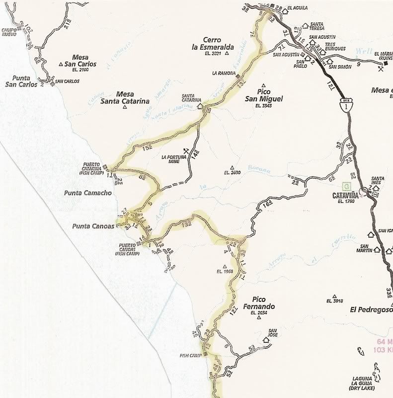
Part of the log, Hwy. 1 to Canoas via Santa Catarina Landing:
Total (and partial) mileage shown from my Tacoma odometer. AAA map mileages for the same section of road were the same or very close to mine.
0.0 (0.0) Take the signed right turnoff to 'Santa Catarina (32 km)' 46.9 miles from El Rosario's Pemex. The road is between Km. 132 and 133. Just
ahead (on Hwy. 1) is the road left to Guayaquil.
This is a good, fast graded road for the first 30 or so miles and it is fun to drive through beautiful cactus gardens.
7.2 (7.2) Road in from left to San Agustin along the old route from El Marmol... where onyx blocks were trucked to the Pacific at Santa Catarina
Landing to be shipped north.
19.2 (12.0) pass through tree shaded Rancho Santa Catarina.
21.1 (1.9) Fork, left to Punta Canoas and right for Santa Catarina Landing... we go right. The road climbs to the the top of a ridge and then drops
down to the coastal plain. The original road used to haul onyx over can be seen to the north.
36.3 (15.2) Fork, we first take right fork and it goes 3.4 miles to fish camp 'Punta Blu'... dead end, so back to this fork and take left branch.
37.3 (1.0) Road left is the route south... ahead goes 1.0 mile to Santa
Catarina fish camp, on the beach.
38.1 (0.8) Turn left and head away from coast.
47.3 (9.2) Come to the Punta Canoas road which forked at Mile 21.1 above. Turn right.
51.3 (4.0) Road to left... we continued straight.
52.3 (1.0) Road to left... we continued straight.
55.2 (2.9) Junction... Ahead goes 1.1 miles to high, look out/ view point, above Punta Canoas... To continue south, turn left.
58.5 (3.3) Join with road heading south (probably coming from the roads that turned left at Mile 51.3 and 52.3).
62.0 (3.5) Puerto Canoas Fish Camp.

[Edited on 2-27-2009 by David K]
|
|
|
gordito
Newbie
Posts: 4
Registered: 2-26-2009
Member Is Offline
|
|
Thanks David, hmmm silt beds going straight into Canoas? Does anyone know if there has been rain in this region this season?
|
|
|
David K
Honored Nomad
        
Posts: 65443
Registered: 8-30-2002
Location: San Diego County
Member Is Offline
Mood: Have Baja Fever
|
|
Well, anything's possible off road in Baja! Even the AAA maps shows the direct road as 'poor' past the La Fortuna copper mine...
|
|
|
David K
Honored Nomad
        
Posts: 65443
Registered: 8-30-2002
Location: San Diego County
Member Is Offline
Mood: Have Baja Fever
|
|
Map close up

|
|
|
gordito
Newbie
Posts: 4
Registered: 2-26-2009
Member Is Offline
|
|
I guess I am hoping some lucky fisherman or surfer who has done the drive recently will chime in with info that's current!
|
|
|
surfer jim
Super Nomad
   
Posts: 1891
Registered: 8-29-2003
Location: high desert
Member Is Offline
|
|
I don't think too many people go this route unless they really want to explore....for surfing it would be much better to drive up from the south and
hit the usual spots.....
|
|
|
David K
Honored Nomad
        
Posts: 65443
Registered: 8-30-2002
Location: San Diego County
Member Is Offline
Mood: Have Baja Fever
|
|
Yah... it is cold, gloomy, lonely area! Commercial fishermen mostly at a couple places.
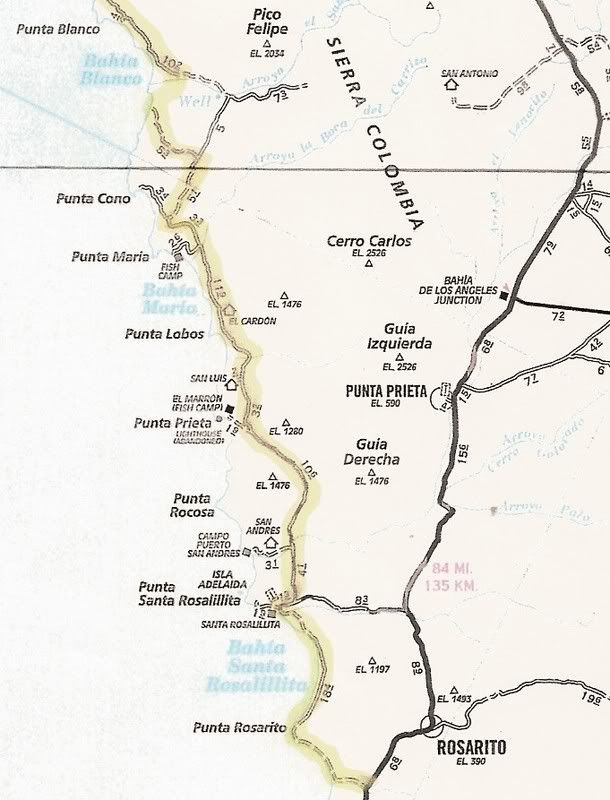
From the south, as Jim says... a paved highway (24 miles south of the L.A. Bay jcn.) goes to Santa Rosalillita harbor. Just a mile before town, a good
graded dirt highway goes way north passing Alejandro's Surf Camp (Puerto San Andres), and on north past Playa el Marron, Punta Lobos, Punta el Diablo,
Punta Maria, Punta Cono... and a graded road bed that was not completed in '07 followed the coast to Punta Blanco... 2WD easy to Maria or Cono in '07.
However, you could drive 10 feet off the graded road and get stuck!
Remember to bring a tire pump (electric) and deflate your tires if you get stuck...
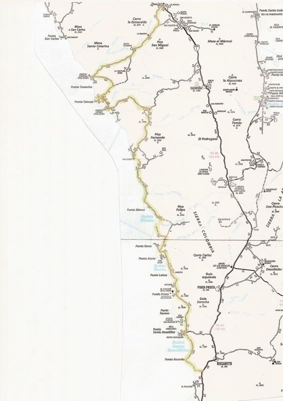
New dirt highway route north of Santa Rosalillita highway highlighted...

[Edited on 2-28-2009 by David K]
|
|
|
gordito
Newbie
Posts: 4
Registered: 2-26-2009
Member Is Offline
|
|
I have been going to those southern approach spots for a while, and even with this new road, I don't imagine it is advisable to try north of Cono or
Blanco without 4wheel capability, and I'm solo.
Not too much time (1 week), so I thought maybe this closer spot, Canoas, might afford opportunities for pescado y olas.
|
|
|
surfer jim
Super Nomad
   
Posts: 1891
Registered: 8-29-2003
Location: high desert
Member Is Offline
|
|
4 wd (or another vehicle) would be the way to go....another member here wanted to do this trip also but never went....maybe it is time for a NOMADS
explore the coast trip.....
|
|
|

