durangotang
Junior Nomad

Posts: 37
Registered: 3-8-2010
Location: Durango, CO
Member Is Offline
|
|
Back for Round 2!
Hey all... I know I don't post up here much but it looks like I'm heading back down to the peninsula.
(my first trip... for those that may recall...http://forums.bajanomad.com/viewthread.php?tid=44643)
I'll be down there from about 10/27-11/3 and will be crossing in Mexicali and hanging around the San Felipe/Gonzaga/Canon de Guadelupe area. If
anyone wants to meet up and go explore some more remote sites or check out some trails... sounds groovy.
I'm also looking for some decent directions for getting to Canon de Guadelupe from San Felipe... and I'm sure more questions will show up in the
meantime...
How's everyone doing? 
[Edited on 10-6-2010 by durangotang]
|
|
|
desertcpl
Super Nomad
Posts: 2408
Registered: 10-26-2008
Location: yuma,az
Member Is Offline
|
|
DURANGO
got a question,, on your first post you mentioned that you went from San Quintin for San Felipe , I can find that route on any of my maps? I have the
AAA map, baja almanac, and the National Geograhic map. what maps are you using
|
|
|
David K
Honored Nomad
Posts: 65575
Registered: 8-30-2002
Location: San Diego County
Member Is Offline
Mood: Have Baja Fever
|
|
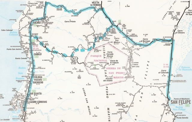
| Quote: | Originally posted by desertcpl
DURANGO
got a question,, on your first post you mentioned that you went from San Quintin for San Felipe , I can find that route on any of my maps? I have the
AAA map, baja almanac, and the National Geograhic map. what maps are you using |
Durango's route (based on my reading and photos from his post) is the solid blue line. Another route, requires a short section of four wheeling, we
took and did a road log: http://vivabaja.com/905 is the dashed line:
|
|
|
David K
Honored Nomad
Posts: 65575
Registered: 8-30-2002
Location: San Diego County
Member Is Offline
Mood: Have Baja Fever
|
|
| Quote: | Originally posted by desertcpl
thanks DK
but what map? can I find for this ,, am I missing something on my maps |
2003-2007 edition AAA map.
|
|
|
desertcpl
Super Nomad
Posts: 2408
Registered: 10-26-2008
Location: yuma,az
Member Is Offline
|
|
| Quote: | Originally posted by David K
| Quote: | Originally posted by desertcpl
thanks DK
but what map? can I find for this ,, am I missing something on my maps |
2003-2007 edition AAA map. |
DK
my AAA map is old,, where can I can a current one,, I live in yuma, we dont have a AAA office here
|
|
|
David K
Honored Nomad
Posts: 65575
Registered: 8-30-2002
Location: San Diego County
Member Is Offline
Mood: Have Baja Fever
|
|
That road (between Valle de Trinidad and San Vicente) has been on all AAA maps for many, many years.
Last I heard, the AAA (Auto Club of Southern California) has stopped the mapping of Baja (seems members are affraid of Mexico or nobody has money to
take a vacation)!
If anyone hears different, great... The one I have is dated 2003-2007.
It was available at Discover Baja Travel Club, book stores, etc. to non-mambers.
The best thing you can get now is the Baja Almanac or the National Geographic Baja Maps.
|
|
|
David K
Honored Nomad
Posts: 65575
Registered: 8-30-2002
Location: San Diego County
Member Is Offline
Mood: Have Baja Fever
|
|
Ah, I just looked at my older AAA maps (1980-96) and I see that the road between San Vicente and Trinidad is not all there, just the two ends. Guess
it was deemed too rough for them to drive it... So, on your older map, the west end on Hwy. 1 is 7 miles south of San Vicente at Rancho Llano Colorado
and the east end is Valle de Trinidad.
It is shown completely on the 1978 AAA map... and once again on the 1997 and newer maps.
[Edited on 10-7-2010 by David K]
|
|
|
durangotang
Junior Nomad
Posts: 37
Registered: 3-8-2010
Location: Durango, CO
Member Is Offline
|
|
I don't know how much repairing they did on that road since I was there, but it was ROUGH. Large sections of it were missing and the bypasses were
interesting to say the least. I had to dig out the riverbank in one place just to have a place to cross due to the washout from the floods.
Personally, I wouldn't go back there without a capable 4x4.
|
|
|
David K
Honored Nomad
Posts: 65575
Registered: 8-30-2002
Location: San Diego County
Member Is Offline
Mood: Have Baja Fever
|
|
A lot of roads and highways were damaged in the Jan. 2010 storm... 3 main bridges on Hwy. 1 washed away!
|
|
|
David K
Honored Nomad
Posts: 65575
Registered: 8-30-2002
Location: San Diego County
Member Is Offline
Mood: Have Baja Fever
|
|
By-the-way, the San Felipe Hwy. to Guadalupe Canyon 'short cut' is a long, tough road... well about 20 miles from the shore of Laguna Salada across to
Cohabuzo Jcn. is the tough section... silt and ruts. he rest is fast and graded.
You do know that the nice camp sites of Arturo's #1 at Guadalupe all no longer... His brother or other family members cut off his supply of hot water
to force him out. The less private camps above or across the canyon are the only ones now... not that they deserve any business!
The GPS waypoints from Guadalupe to Hwy. 5 are on my GPS web page at ViavBaja.com The Hwy. 5 turnoff is at the sand dunes halfway between Mexicali and
San Felipe, at the south end of the Salada elevated crossing levee.
|
|
|
durangotang
Junior Nomad
Posts: 37
Registered: 3-8-2010
Location: Durango, CO
Member Is Offline
|
|
| Quote: | Originally posted by David K
By-the-way, the San Felipe Hwy. to Guadalupe Canyon 'short cut' is a long, tough road... well about 20 miles from the shore of Laguna Salada across to
Cohabuzo Jcn. is the tough section... silt and ruts. he rest is fast and graded.
You do know that the nice camp sites of Arturo's #1 at Guadalupe all no longer... His brother or other family members cut off his supply of hot water
to force him out. The less private camps above or across the canyon are the only ones now... not that they deserve any business!
The GPS waypoints from Guadalupe to Hwy. 5 are on my GPS web page at ViavBaja.com The Hwy. 5 turnoff is at the sand dunes halfway between Mexicali and
San Felipe, at the south end of the Salada elevated crossing levee. |
OK I know the turnoff you're talking about at the southern crossing of Laguna Salada. I always had a suspicion that that was the road, but couldn't
verify.
That's a bummer about the goings on in the Canon... I'll have to do some thinking about whether or not I want to give them any of my money... I
loved those lower campsites...
|
|
|