DonBaja
Nomad

Posts: 139
Registered: 5-9-2006
Location: OC
Member Is Offline
Mood: Just Cruzin'
|
|
Old Mill to BOLA
Im putting a offroad trip together that would start out Day 1: from Tecate to Mikes or Coyote. Day 2: go to the Old Mill, Day 3: Old Mill to BOLA,
Day 4: Bay of LA to San Felipe , Day 5: San Felipe back to Tecate.
It looks like Day 3 from the Old Mill to BOLA would be alot of pavement. We are in very capable prerunner buggies, and would prefer to stay on the
dirt as much as possible. Any suggestions on this section to Bay of LA ??
|
|
|
David K
Honored Nomad
Posts: 65563
Registered: 8-30-2002
Location: San Diego County
Member Is Offline
Mood: Have Baja Fever
|
|
You want to add dirt to the run without going too far out of the way?
1) Leaving El Rosario, on the south side of the big bridge, turn left off the highway and take road up the valley, climb the Vibora grade, pass
Sauzalito copper mine, return to Mex. 1 at the Martires cafe (Km. 103+). Photos at http://vivabaja.com/705 (first 3 pages)
2) Take the El Marmol road (Km. 149) 1/2 mile north to the original Baja main road, turn right (south, and it is very rough for about 6 miles then
becomes fun) take it past Agua Dulce (intersting and historic spring 1/4 mile to the left of old road), past La Virgen shrine built in the 1950's or
before, and return to Hwy. 1 by the Cataviña painted cave parking area (Km. 176). http://vivabaja.com/705/page7.html and http://forums.bajanomad.com/viewthread.php?tid=48637
3) Take the original road to Bahia de los Angeles off Hwy. 1 (used for Baja 1000 races) at Km. 270.. it joins the paved L.A. Bay road in 12 miles.
Passes the Desengaño gold mine ruins and the access road to Tinaja de Yubay.
[Edited on 4-19-2011 by David K]
|
|
|
DonBaja
Nomad
Posts: 139
Registered: 5-9-2006
Location: OC
Member Is Offline
Mood: Just Cruzin'
|
|
I'm looking for a way to get there via as much dirt as possible..trying to avoid the pavement is the goal..
|
|
|
David K
Honored Nomad
Posts: 65563
Registered: 8-30-2002
Location: San Diego County
Member Is Offline
Mood: Have Baja Fever
|
|
Well... there is the route east from San Quintin into the foothills that then turns south and comes out at Km. 103+ (Los Martires Cafe) as does the El
Rosario/ La Vibora road I mentioned.
This route was used for the Baja 2000 race in 2000... I drove it north then west in 2005: http://vivabaja.com/1105/page3.html It very well could be impassable to 4 wheeled vehicles following the floods of Jan. 2010?
Here is the intro:
Off road into Baja high desert...
The 57 mile dirt road goes north from Km.103.5 (28.5 miles southbound from El Rosario's Pemex) to about 2,600 feet in 28 miles then drops toward the
Pacific returning to Km.24.5 on Hwy. 1 at El Socorro, 20 miles north of El Rosario.
The first 25 miles are easy 2WD road and permits most vehicles to enter the cactus gardens.
See photos on web page.
The remaining 32 miles will require 4WD and ground clearance to negotiate bad erosion in a road that appears abandoned.
This road has been used for the Baja 2000 off road race (Nov. 2000) and a couple of earlier Baja races.
Here's the route map and log (going the opposite direction from your course):
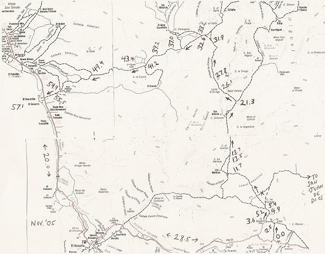
Trip Road Log (in miles) and 21 GPS waypoints (Map Datum NAD27)
0.0 Leave Hwy. 1 (28.5 mi. from El Rosario Pemex) at cafe just past Km. 103, head north. 30°03.81', 115°20.87'
2.5 Fork, go left
3.6 El Sauzalito ruins on left at 30°05.89', 115°21.76'
4.9 Cross San Juan de Dios river 30°06.83', 115°21.28'
5.2 Fork, go right (left goes back to El Rosario via La Vibora grade) 30°07.04', 115°21.33'
5.4 Fork, go left (right goes to San Juan de Dios) 30°07.22', 115°21.42'
11.7 Fork, go right (left goes to Rancho Los Martires)
13.5 Cross Arroyo Los Matires/ Arroyo Grande 30°12.37', 115°26.33'
13.7 Road in from left to Rancho Los Martires. Rancho San Antonio is passed about five miles ahead
21.3 Fork just north of Arroyo El Portezuelo crossing, go left (right goes to San Miguel and La Suerte) 30°18.42', 115°42.28'
26.1 Fork, go left (right goes to ranch). Only 4WD beyond here.
27.8 Bulldozed switchback grade to ridge top 30°22.26', 115°29.21'
31.9 Fork, go left (right for La Suerte) 30°24.79', 115°29.21'
32.6 Jcn. with old El Socorro to La Suerte road, turn left 30°25.18', 115°29.72'
33.2 Jcn. with road north to El Agua Escondida 30°24.97', 115°30.27'. A second road north is at 30°24.28', 115°31.51'
37.0 'Petroglyph Park' 30°24.19', 115°33.38'
39.2 Fork, go left (right goes 0.9 mi. to blue palms and beyond) 30°23.58', 115°35.01'
41.2 Jcn. road south to El Canuto 30°22.51', 115°36.24'
43.4 El Cipres (abandoned ranch) 30°22.10', 115°37.98'
49.4 Fork, go left (right to Nuevo Odisea) 30°21.56', 115°42.80'
54.8 Jcn., road in from left to Tres Palmas 30°19.96', 115°46.82'
54.9 Old road to north (to Nuevo Odisea) 30°19.94', 115°46.85'
55.5 Join road along south side of river valley, turn right 30°19.66', 115°47.25'
57.1 Hwy. 1 near El Socorro (Km. 24-25). El Rosario is 20.0 mi. south. 30°19.25', 115°48.77'
|
|
|
Desertbull
Senior Nomad
Posts: 558
Registered: 8-27-2003
Member Is Offline
|
|
We do it all the time and hit the dirt just past the bridge at Las Parritas (just past that Pemex 1 mile south of the Y intersection of Hwy 1 &
Cielto Lindo turn off) into the mini-grand canyon east of Cipres Summit and way far south...no support and limited access so you better know what
you're doing in there, that's why they don't race that way anymore.
DREAM IT! PLAN IT! LIVE IT!
|
|
|
David K
Honored Nomad
Posts: 65563
Registered: 8-30-2002
Location: San Diego County
Member Is Offline
Mood: Have Baja Fever
|
|
Well, a lot more miles but if you turn off Hwy. 1 near Guayaquil and run down to Punta Canoas on the coast and south to Bahia Blanca... you then could
turn east to San Antonio and pop out on Hwy. 1 just south of the old L.A. Bay road I mentioned... Hey amigo, I am trying to help here!
|
|
|
Desertbull
Senior Nomad
Posts: 558
Registered: 8-27-2003
Member Is Offline
|
|
well there...KD even gave you some detailed notes with GPS waypoints but don't come out to the Hwy, you can go all the way south if you are
resourceful enough to figure it out...nice map David :-)
DREAM IT! PLAN IT! LIVE IT!
|
|
|
David K
Honored Nomad
Posts: 65563
Registered: 8-30-2002
Location: San Diego County
Member Is Offline
Mood: Have Baja Fever
|
|
| Quote: | Originally posted by Desertbull
well there...KD even gave you some detailed notes with GPS waypoints but don't come out to the Hwy, you can go all the way south if you are
resourceful enough to figure it out...nice map David :-) |
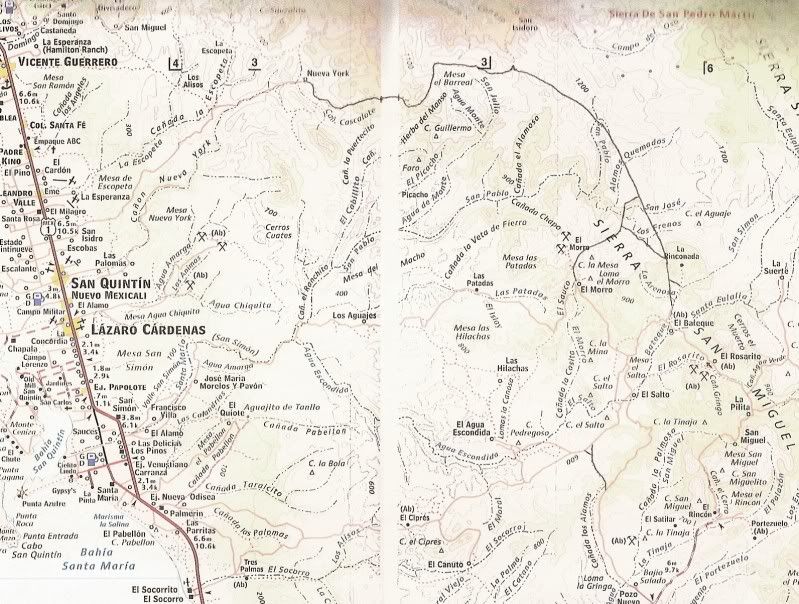
Thanks Tim, yes indeed there is a road now past San Juan de Dios and El Metate that can be taken to El Aguila on the old road... Other roads too...
You can spend hours on Google Earth flying over them and recording GPS waypoints!
Here are some unmapped roads drawn onto the new Almanac...
[Edited on 4-20-2011 by David K]
|
|
|
DonBaja
Nomad
Posts: 139
Registered: 5-9-2006
Location: OC
Member Is Offline
Mood: Just Cruzin'
|
|
Muchas Gracias DK and DB !!! In 2006 Malcolm gave me quick directions but we could never find the cutoff  so we ended up slabbing it most of the way..With this help we will try again.. so we ended up slabbing it most of the way..With this help we will try again..
|
|
|
DonBaja
Nomad
Posts: 139
Registered: 5-9-2006
Location: OC
Member Is Offline
Mood: Just Cruzin'
|
|
| Quote: | Originally posted by Desertbull
well there...KD even gave you some detailed notes with GPS waypoints but don't come out to the Hwy, you can go all the way south if you are
resourceful enough to figure it out...nice map David :-) |
Would you suggest continuing south by crossing 1 at Guayaquil and going to Bahia Blanco, then head east towards 1, comming out north of the cutoff to
bola ?
|
|
|
TMW
Select Nomad
Posts: 10659
Registered: 9-1-2003
Location: Bakersfield, CA
Member Is Offline
|
|
Going east near KM15/16 leads back into the hills then south as DK mentions coming out at KM103. Pavement to the Puerto Santa Catarina turn off at
KM133 and out toward the coast at Punta Canoas picking up the route south. DK has this on a trip posted for another Nomad here. Just reverse his
directions and take it to a Jct at 29-05-22x114-36-36 and go east 24.6 miles to a jct at 29-11-44x114-16-55. There is a house to the N (your left
side) on a hill. Turn right and it will take you to KM270. Cross hwy 1 and pick up the Desengano mine road go around to the LA Bay hwy. Coordinates
are Datum 27 in Hr-Min-Sec.
I did a trip report on this section also posted along with DKs at
http://forums.bajanomad.com/viewthread.php?tid=52369
Also look at http://forums.bajanomad.com/viewthread.php?tid=40038&pag...
[Edited on 4-20-2011 by TW]
[Edited on 4-20-2011 by TW]
|
|
|
Desertbull
Senior Nomad
Posts: 558
Registered: 8-27-2003
Member Is Offline
|
|
Zactly what TW described...you'll be ready for some cervezas when you arrive to Costa del Sol...breathe deep and enjoy the world of Baja! Life is a
dream on the dirt trails!
DREAM IT! PLAN IT! LIVE IT!
|
|
|
David K
Honored Nomad
Posts: 65563
Registered: 8-30-2002
Location: San Diego County
Member Is Offline
Mood: Have Baja Fever
|
|
That soup at Costa del Sol is intoxicating!
|
|
|
DonBaja
Nomad
Posts: 139
Registered: 5-9-2006
Location: OC
Member Is Offline
Mood: Just Cruzin'
|
|
Thanks very much DK DB TW. I really wanted to head further south on this trip like down to Scorpion Bay, but time constraints for some in the group
are keeping us north on this run, hopefully in October !!! This should be a fun 5 day run 
|
|
|
TMW
Select Nomad
Posts: 10659
Registered: 9-1-2003
Location: Bakersfield, CA
Member Is Offline
|
|
Since your in buggies let us know what the road out of Mike's to El Coyote is like. We've heard it's OK for bikes but for 4 wheelers we're not sure.
The problem area seems to be around the El Corral Falso area (in the almanac) near the junction, a little more than 5 miles from Mike's.
|
|
|
DonBaja
Nomad
Posts: 139
Registered: 5-9-2006
Location: OC
Member Is Offline
Mood: Just Cruzin'
|
|
| Quote: | Originally posted by TW
Since your in buggies let us know what the road out of Mike's to El Coyote is like. We've heard it's OK for bikes but for 4 wheelers we're not sure.
The problem area seems to be around the El Corral Falso area (in the almanac) near the junction, a little more than 5 miles from Mike's.
|
Ok will do...Last March 2010 we couldn't get from Mikes to Coyote and we were in our "Locked Up" 4x4's for that trip, We ended up going the long way
around via the Vineyard Road out of Valle T.. I think my buggy can go places my hard core rock crawler can't ???
[Edited on 4-21-2011 by DonBaja]
|
|
|
DonBaja
Nomad
Posts: 139
Registered: 5-9-2006
Location: OC
Member Is Offline
Mood: Just Cruzin'
|
|
I want to follow up on the road from mikes to el coyote...We got to Mikes around 3pm and our leader decided we should try taking the route to the
left...we got to within about 2 miles of the rancho and the road was washed out and we could not pass. So we headed back to Mikes and spent the night.
The next morning we went up the hill from Mikes and the road was pretty decent until about 5-6 miles from Mikes, where we encountered some pretty
washed out areas with large boulders. It appeared like some jeeps may have passed through recently but nothing as wide track as my buggy. It took a
little effort but we eventually got all 3 buggys through and made it to el coyote. We had to explain to Yolita (sp) why we did not make it the
previous night and that we were headed to the Old Mill tonight but we would retun on friday and spend the night, (they are the nicest people you can
ever meet).
After the old mill on thursday night we returned to el coyote friday and we had perfect timing, because they were moving their cattle from the
surrounding area into the corral for branding of the calfs. We got to watch some of what a real working ranch is like..
Saturday we decided not to go back to tecate via mikes, so our other option was to go up to the vineyard road and into valle T, against prerunning
traffic..we took that option and were very careful to pull over for any prerunners (we saw 5 total).
We opted to not go to BOLA on this trip and will make that run in October..
|
|
|
TMW
Select Nomad
Posts: 10659
Registered: 9-1-2003
Location: Bakersfield, CA
Member Is Offline
|
|
Thanks. I was going to try it from Mikes to El Coyote on Thursday but I think I'll pass on it this trip and come back later when I have more time to
play around.
|
|
|
DonBaja
Nomad
Posts: 139
Registered: 5-9-2006
Location: OC
Member Is Offline
Mood: Just Cruzin'
|
|
TW FYI it took us 3 hours to get to coyote from mikes...
|
|
|


