Hook
Elite Nomad

Posts: 9013
Registered: 3-13-2004
Location: Sonora
Member Is Offline
Mood: Inquisitive
|
|
New images on Google Earth.
There are new images of the San Carlos area on Google Earth, Google Maps, etc. Well, new to me. They were taken about 5 months ago. The previous ones
were from 2007.
Check out your neighborhood over in Baja and see if it has been updated.
|
|
|
Santiago
Ultra Nomad
Posts: 3544
Registered: 8-27-2003
Member Is Offline
|
|
Hey, you're right, south BOLA is now updated.
|
|
|
David K
Honored Nomad
Posts: 65549
Registered: 8-30-2002
Location: San Diego County
Member Is Offline
Mood: Have Baja Fever
|
|
| Quote: | Originally posted by Santiago
Hey, you're right, south BOLA is now updated. |
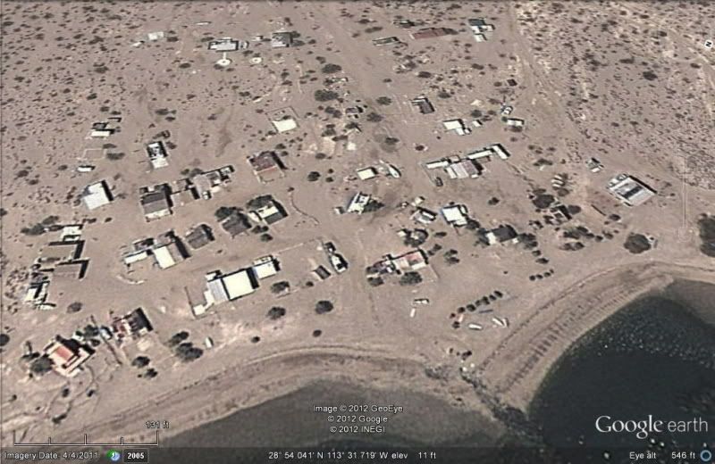
Camp Gecko on 4-4-11... are you waving Jim?
|
|
|
OCEANUS
Nomad
Posts: 139
Registered: 10-11-2008
Location: Dana Point; L.A. Bay
Member Is Offline
|
|
Last week, one of my students showed me the Google Earth update of Las Animas that just happened to coincide with our Marine Ecology field studylast
year. We scrolled around, and you can actually see several of the student groups out doing their studies!
We plan on taking screen shots of these satellite images and incorporating them into my parent presentation I give each year.
Pretty cool...what are the chances?
|
|
|
Howard
Super Nomad
Posts: 2353
Registered: 11-13-2007
Location: Loreto/Manhattan Beach/Kona
Member Is Offline
Mood: I'd rather regret the things I've done than regret the things I haven't done.
|
|
The images at my location in Loreto seems to be around 2-3 years old.
We don't stop playing because we grow old;
we grow old because we stop playing
George Bernard Shaw
|
|
|
RnR
Senior Nomad
Posts: 841
Registered: 5-1-2010
Member Is Offline
|
|
FYI
The image date is posted on the bottom of the Google Earth screen. You can also slide the "Image History" slider back and forth to view older/newer
images and see changes as they ocuured.
[Edited on 6-23-2012 by RnR]
|
|
|
doublelimits
Newbie
Posts: 11
Registered: 1-26-2011
Member Is Offline
|
|
I happened to notice the same thing, you can see our boats up at the cove conducting the Reef Studies.
| Quote: | Originally posted by OCEANUS
Last week, one of my students showed me the Google Earth update of Las Animas that just happened to coincide with our Marine Ecology field studylast
year. We scrolled around, and you can actually see several of the student groups out doing their studies!
We plan on taking screen shots of these satellite images and incorporating them into my parent presentation I give each year.
Pretty cool...what are the chances? |
|
|
|
El Jefe
Super Nomad
Posts: 1027
Registered: 10-27-2003
Location: South East Cape
Member Is Offline
|
|
I think it's fun to wave the little street view man over a section of Baja to see which streets and dirt roads have been driven by the Google car.
Kind of random in our area. Why did they go down THAT ranch road? But seems like more all the time.
No b-tchin\' in the Baja.
|
|
|
CortezBlue
Super Nomad
Posts: 2213
Registered: 11-14-2006
Location: Fenix/San Phelipe
Member Is Offline
|
|
San Felipe is still about 5 or 6 years old.
|
|
|
David K
Honored Nomad
Posts: 65549
Registered: 8-30-2002
Location: San Diego County
Member Is Offline
Mood: Have Baja Fever
|
|
| Quote: | Originally posted by OCEANUS
Last week, one of my students showed me the Google Earth update of Las Animas that just happened to coincide with our Marine Ecology field studylast
year. We scrolled around, and you can actually see several of the student groups out doing their studies!
We plan on taking screen shots of these satellite images and incorporating them into my parent presentation I give each year.
Pretty cool...what are the chances? |
Any ideas on the purpose of the 'mystery walls' on the hill, 2 miles from the beach? http://vivabaja.com/109 Choral Pepper with the Erle Stanley Gardner expedition in 1966 believed it was the started mission of Santa Maria
Magdalena, as shown on the 1757 Jesuit map... in that region, south of L.A. Bay...??!!
|
|
|
vgabndo
Ultra Nomad
Posts: 3461
Registered: 12-8-2003
Location: Mt. Shasta, CA
Member Is Offline
Mood: Checking-off my bucket list.
|
|
Please pardon a quick high jack. Google has done high resolution and street view upgrades, this year in NE Japan. It is amazing use of technology.
Visit the tsunami devastation. Now back to your regularly scheduled programming.
Undoubtedly, there are people who cannot afford to give the anchor of sanity even the slightest tug. Sam Harris
"The situation is far too dire for pessimism."
Bill Kauth
Carl Sagan said, "We are a way for the cosmos to know itself."
PEACE, LOVE AND FISH TACOS
|
|
|
Neal Johns
Super Nomad
Posts: 1687
Registered: 10-31-2002
Location: Lytle Creek, CA
Member Is Offline
Mood: In love!
|
|
New images on the Pole Line Road Basketball Hill area also. Used to be hidden by clouds - now clouds have moved. 
My motto:
Never let a Dragon pass by without pulling its tail!
|
|
|
durrelllrobert
Elite Nomad
Posts: 7393
Registered: 11-22-2007
Location: Punta Banda BC
Member Is Offline
Mood: thriving in Baja
|
|
5 or 6 years old?
| Quote: | Originally posted by CortezBlue
San Felipe is still about 5 or 6 years old. |
Father Ferdinand Končak arrived and christened the bay San Felipe de Jesús. In 1766. That makes it 256 years old 
Bob Durrell
|
|
|
David K
Honored Nomad
Posts: 65549
Registered: 8-30-2002
Location: San Diego County
Member Is Offline
Mood: Have Baja Fever
|
|
| Quote: | Originally posted by durrelllrobert
| Quote: | Originally posted by CortezBlue
San Felipe is still about 5 or 6 years old. |
Father Ferdinand Končak arrived and christened the bay San Felipe de Jesús. In 1766. That makes it 256 years old
|
It was even before then!
Consag's 1747 map...
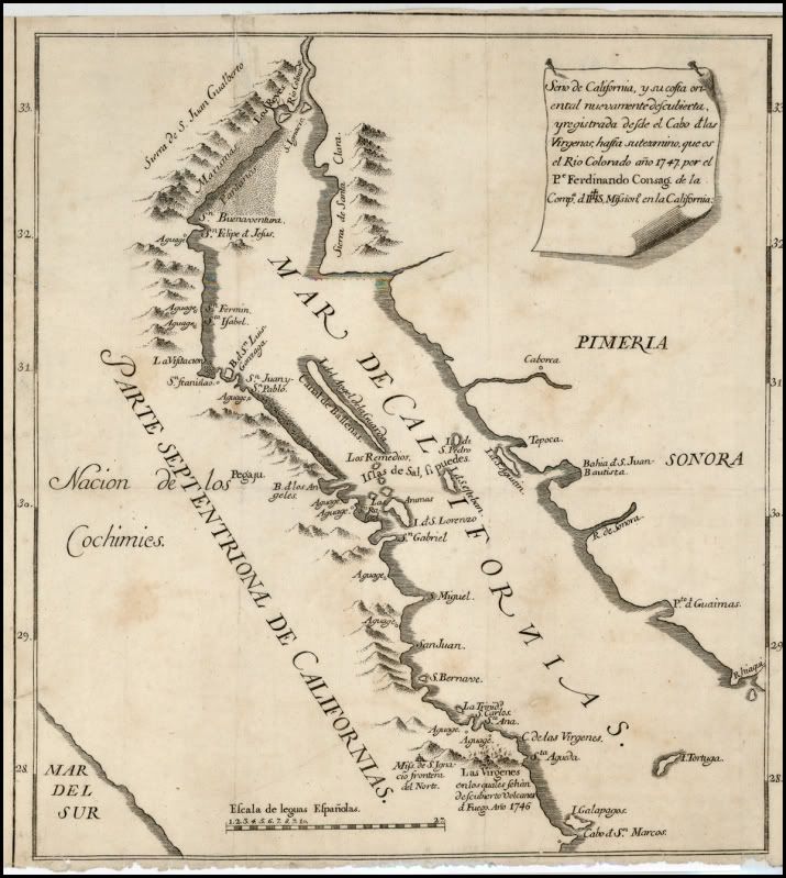
Close up of San Felipe, in a copied version, 1748:
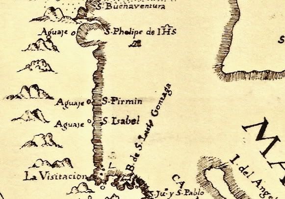
Consag died on Dec. 10, 1759.
[Edited on 6-25-2012 by David K]
|
|
|
Riom
Nomad
Posts: 492
Registered: 12-17-2004
Member Is Offline
|
|
Bing Maps had a big update today. In San Felipe at least some of the images are now updated to mid/late 2011 (there's some construction shown from
that time, but not all of it).
There do seem to be two series of images though, which mismatch in places: see Pete's Camp in San Felipe:
http://binged.it/Q7rCgF
It's not clear which set of images is newer, I'm guessing the lighter crisper ones showing the beach. The resolution seems to be the same.
Rob
[Edited on 2012-6-26 by Riom]
|
|
|
David K
Honored Nomad
Posts: 65549
Registered: 8-30-2002
Location: San Diego County
Member Is Offline
Mood: Have Baja Fever
|
|
Bump for 55steve.
|
|
|
grace59
Senior Nomad
Posts: 614
Registered: 9-14-2004
Location: San Felipe, Baja, Mexico
Member Is Offline
|
|
| Quote: | Originally posted by Riom
Bing Maps had a big update today. In San Felipe at least some of the images are now updated to mid/late 2011 (there's some construction shown from
that time, but not all of it).
There do seem to be two series of images though, which mismatch in places: see Pete's Camp in San Felipe:
http://binged.it/Q7rCgF
It's not clear which set of images is newer, I'm guessing the lighter crisper ones showing the beach. The resolution seems to be the same.
Rob
[Edited on 2012-6-26 by Riom] |
Yes, It has been updated, but the images are actually a couple of years old!! I can tell because I can finally see my house on there, but can tell
that it is older because I can see where the footings for our perimeter wall are dug in...and the wall has been up for about a year and a half.
Whenever I hear that rainy, chill wind blow. I think it may be time to head for Mexico. Tengo que obedecer mi corazon!
|
|
|