| Pages:
1
2 |
clubfred
Junior Nomad

Posts: 84
Registered: 1-12-2006
Member Is Offline
|
|
One Month Countdown! (and Malarrimo question)
Heading south (from Nelson, BC) on January 27th and I CANNOT wait! Get me out of this snow!!!
This year we are determined to make it to Malarrimo beach. All of our previous attempts have gone sideways for various reasons but this year I know
the fates will smile on us. (Please!)
We'll be heading in with a 4x4 Toyota Tundra, (RAWR!). Our buddies will also have a 4x4 but it will be slightly less off-road friendly. So, any advice
from Malarrimo veterans (and comments from the peanut gallery, too, I'm sure, lol)? Fire away!
One more month!
|
|
|
DianaT
Select Nomad
Posts: 10020
Registered: 12-17-2004
Member Is Offline
|
|
Be sure to check with Russ and with BajaDixon as they have both been out there recently. However, it was before the last rain storms and Russ
traveled in a Ranger (I think) and BajaDixon and group traveled in Razors.
You can also check with Jean from the Bahia Asuncion B & B because see went out there with both of those groups. http//:www.bahiaasuncionbb.com
[url=http//:www.bahiaasuncionbb.com]Bahia Asuncion B & B [/url]
Good luck and watch out for the quick sand!
|
|
|
clubfred
Junior Nomad
Posts: 84
Registered: 1-12-2006
Member Is Offline
|
|
Thanks Diana! Will watch, promise.
|
|
|
Udo
Elite Nomad
Posts: 6364
Registered: 4-26-2008
Location: Black Hills, SD/Ensenada/San Felipe
Member Is Offline
Mood: TEQUILA!
|
|
Jana and I went there last week.
u2U me for more details, and I'll answer as much as you want, Fred.
From the Asunción turn-off, there is about 18 miles of paved road. Then there is 15 miles of good graded dirt, and after that, there is about 18 miles
of good pavement into Bahia Tortuga.
There is a Pemex @ Tortuga, and their pier now has a pump house for the boats to use (no more bringing fuel from a barrel).
The beach-conmbing beaches are still barren because the Japan tsunami crap is still in the middle of the Pacific.
When I spoke with the senior fish camp person (Elijo), they only found a full soda bottle from the Japanese quake so far, and don't expect to find
much for at least a year.
I'll post a full report this coming weekend. Left BOLA early this morning and managed to make it to El Marmol...ROUGH RIDE...especially with a kayak
strapped to the roof.
Mañana, buddy!
Udo
Youth is wasted on the young!
|
|
|
David K
Honored Nomad
Posts: 65549
Registered: 8-30-2002
Location: San Diego County
Member Is Offline
Mood: Have Baja Fever
|
|
There is more than 1 Malarrimo and the famous beach is reached by the canyon road that goes north from a point 1/2 mike east of the San Jose de Castro
driveway. The other Malarrimo is a fish camp reached from Tortugas as Udo mentioned.
|
|
|
Bajatripper
Ultra Nomad
Posts: 3152
Registered: 3-20-2010
Member Is Offline
|
|
| Quote: | Originally posted by David K
There is more than 1 Malarrimo and the famous beach is reached by the canyon road that goes north from a point 1/2 mike east of the San Jose de Castro
driveway. The other Malarrimo is a fish camp reached from Tortugas as Udo mentioned. |
I think the San Jose de Castro entrance is the better of the two, less visited and therefore, you are likely to find better stuff (although I can't
say that I've ever found anything of note on my three trips there). The isolation is also nice. We had a coyote come into our camp after dark and open
a five-gallon water jug with screw-on top, so keep even your water stowed at night if you go there.
There most certainly is but one side to every story: the TRUTH. Variations of it are nothing but lies.
|
|
|
DianaT
Select Nomad
Posts: 10020
Registered: 12-17-2004
Member Is Offline
|
|
| Quote: | Originally posted by David K
There is more than 1 Malarrimo and the famous beach is reached by the canyon road that goes north from a point 1/2 mike east of the San Jose de Castro
driveway. The other Malarrimo is a fish camp reached from Tortugas as Udo mentioned. |
However, one can reach the "junk" beach from the fish camp. One person we know hired a guide at the fish camp. Others we know drove ATVs from the
fish camp to the "junk" beach. Hiring a guide is an option.
The people I mentioned above traveled the canyon road.
|
|
|
TMW
Select Nomad
Posts: 10659
Registered: 9-1-2003
Location: Bakersfield, CA
Member Is Offline
|
|
If you go by way of San Jose de Castro stay on top of the sand on the side of the wash as you get closer to the beach. There are areas of mud that
will sink your vehicle usually where the sand does not exist. Also stay away of the mud flats to the east on the beach or be mindfull of the danger
they pose. The last time we were there a very large badger was living maybe a mile from the beach area. I ran with 5 or 6 coyotes on my motorcycle up
the beach until they got tired.
|
|
|
clubfred
Junior Nomad
Posts: 84
Registered: 1-12-2006
Member Is Offline
|
|
Thanks everyone. Yeah, we're looking for "junk", so whatever the easiest safest way to find said junk is, that's what we want.
More detailed reply to follow - busy working tonight!
|
|
|
dtbushpilot
Ultra Nomad
Posts: 3297
Registered: 1-11-2007
Location: Buena Vista BCS
Member Is Offline
Mood: Tranquilo
|
|
Here is a link to the trip report from our adventure to Malarrimo. It was several years ago but I doubt that much has changed. We went in through the
San Juan de Castro turnoff. Some people have said that you can reach this part of the beach from the fish camp but I didn't see any evidence of a road
or trail leading to this place from anywhere else. Has anyone reached the beach where the "redwood logs" are from a different route?
http://forums.bajanomad.com/viewthread.php?tid=32808#pid4262...
"Life is tough".....It's even tougher if you're stupid.....
|
|
|
DianaT
Select Nomad
Posts: 10020
Registered: 12-17-2004
Member Is Offline
|
|
| Quote: | Originally posted by dtbushpilot
.....Some people have said that you can reach this part of the beach from the fish camp but I didn't see any evidence of a road or trail leading to
this place from anywhere else. Has anyone reached the beach where the "redwood logs" are from a different route?
|
Don't know if they got to the "redwood logs" , and from what I have heard, it is not really a road or trail --- just travel along the beach.
http://forums.bajanomad.com/viewthread.php?tid=50337#pid5855...
There was a film maker who stayed with us who hired a guide in the fish camp to head out that way --- don't know what they saw.
I loved your report when you wrote it, and it is still a great read.
|
|
|
willardguy
Elite Nomad
Posts: 6451
Registered: 9-19-2009
Member Is Offline
|
|
if you continue west past the asuncion turnoff theres a road that heads north. off that road to the west you can pick up the aqueduct that feeds punta
eugenia. it'll take you right to malarrimo.
|
|
|
David K
Honored Nomad
Posts: 65549
Registered: 8-30-2002
Location: San Diego County
Member Is Offline
Mood: Have Baja Fever
|
|
To help see the area... on the AAA map:
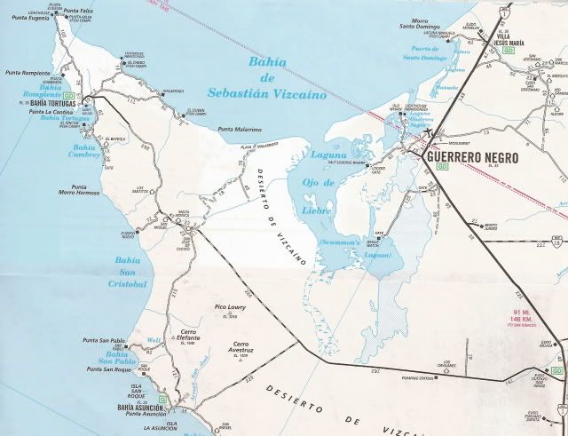

Now you see that the fish camp named Malarrimo is maybe 20 miles+ from the original scavenger's beach, Playa Malarrimo.
[Edited on 12-28-2012 by David K]
|
|
|
willardguy
Elite Nomad
Posts: 6451
Registered: 9-19-2009
Member Is Offline
|
|
now draw a line between playa malarrimo and the asuncion turnoff. sand all the way to malarrimo mostly following the aqueduct.
obviously not on a AAA map
[Edited on 12-28-2012 by willardguy]
|
|
|
David K
Honored Nomad
Posts: 65549
Registered: 8-30-2002
Location: San Diego County
Member Is Offline
Mood: Have Baja Fever
|
|
Is that 4.8 mile piece of a road part of it? We should be able to see it on Google Earth... if the images are made after the pipeline road!
|
|
|
willardguy
Elite Nomad
Posts: 6451
Registered: 9-19-2009
Member Is Offline
|
|
it is visible from google earth. its a little hard to follow from space and sections are hard to follow from 4 feet up. done in a very capable 1st
generation 4runner.
|
|
|
David K
Honored Nomad
Posts: 65549
Registered: 8-30-2002
Location: San Diego County
Member Is Offline
Mood: Have Baja Fever
|
|
| Quote: | Originally posted by willardguy
it is visible from google earth. its a little hard to follow from space and sections are hard to follow from 4 feet up. done in a very capable 1st
generation 4runner. |
Yes indeed!
I took your pipeline road from where it leaves the Tortugas highway to the Malarrimo Beach arroyo road, then followed the arroyo to the beach....
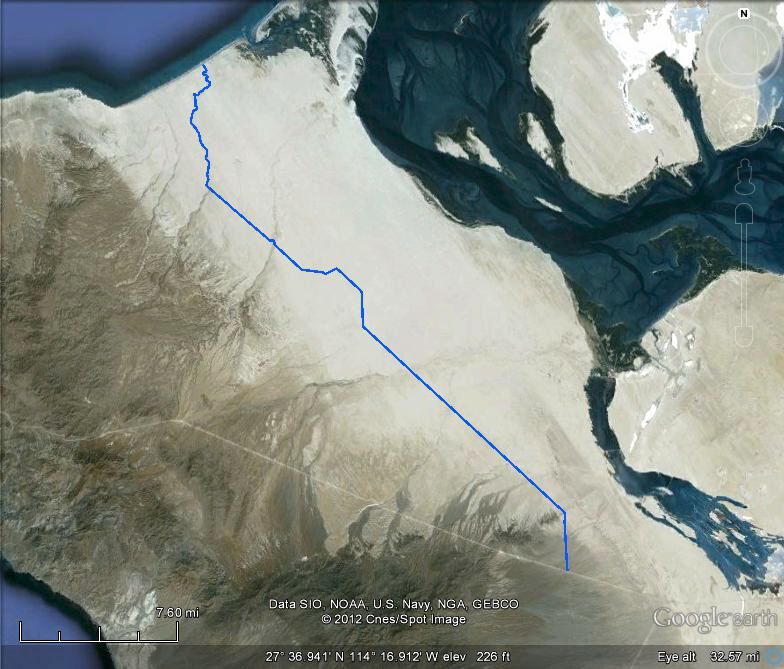
The Tortugas Highway is very easy to see, and the Asuncion highway junction is at the top of the G in Google. The auto club did indeed map 4.8 miles
of it!
|
|
|
larryC
Super Nomad
Posts: 1499
Registered: 8-11-2008
Location: BoLA
Member Is Offline
|
|
For what it is worth, I was in there last June, on the castro ranch road. That arroyo is really beautiful. I made it in and out in 2wd. My truck is
4wd but I never needed it. Things may have changed by now. If, when you get to the beach, you drive west on the beach about 4 miles there is another
arroyo and if you drive up there you will meet up with the road that goes to the west along the coast through the malirimo fish camp and on to punta
euginia. You will most likely need 4wd for that trip.
Hope you make it this time.
Larry
PS If you need to replenish you fresh water supply, stop when you get to the aquaduct pipe, walk up the hill to the west and at the top there is a
riser and a valve handle. Open it and get some water.
Off grid, 12-190 watt evergreen solar panels on solar trackers, 2-3648 stacked Outback inverters, 610ah LiFePo4 48v battery bank, FM 60 and MX60
Outback charge controllers, X-240 Outback transformer for 240v from inverters, 6500 watt Kubota diesel generator.
|
|
|
David K
Honored Nomad
Posts: 65549
Registered: 8-30-2002
Location: San Diego County
Member Is Offline
Mood: Have Baja Fever
|
|
| Quote: | Originally posted by larryC
For what it is worth, I was in there last June, on the castro ranch road. That arroyo is really beautiful. I made it in and out in 2wd. My truck is
4wd but I never needed it. Things may have changed by now. If, when you get to the beach, you drive west on the beach about 4 miles there is another
arroyo and if you drive up there you will meet up with the road that goes to the west along the coast through the malirimo fish camp and on to punta
euginia. You will most likely need 4wd for that trip.
Hope you make it this time.
Larry
PS If you need to replenish you fresh water supply, stop when you get to the aquaduct pipe, walk up the hill to the west and at the top there is a
riser and a valve handle. Open it and get some water. |
Wonderful report Larry.... Here is what I saw on GE:
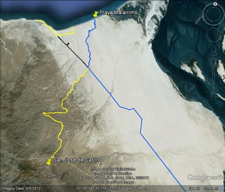
Yesterday, I highlighted the shortcut to Malarrimo from the Asuncion/Tortugas road, in blue. Then today, I added the original canyon road from San
Jose de Castro to Malarrimo (yellow to where it meets the shortcut.
Then I added the west road to the beach via the other arroyo out to the pipe road, in yellow.
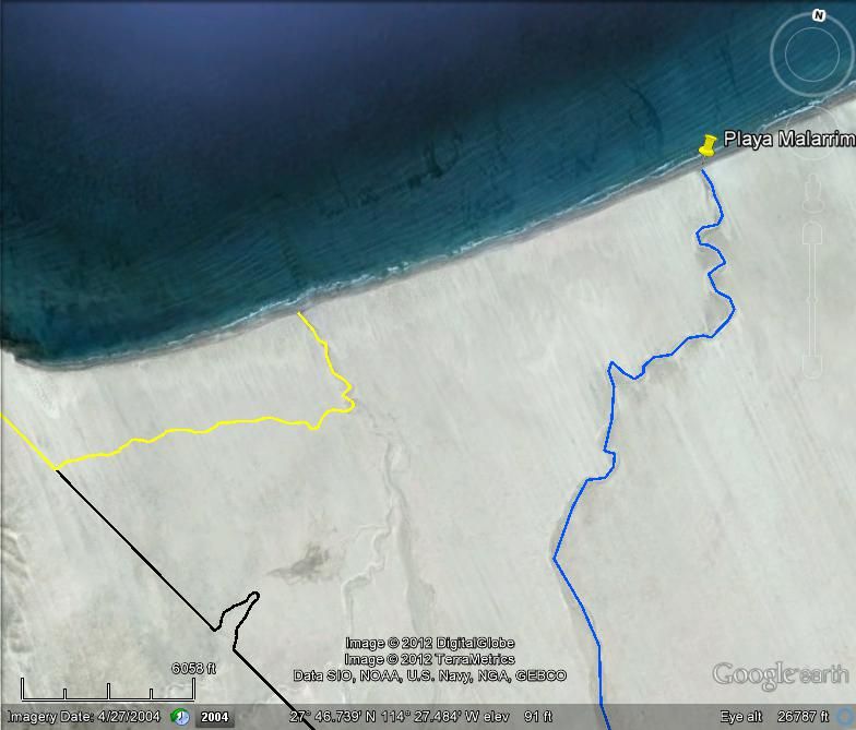
The pipe road between the two Malarrimo roads is in black.
Thank you for your field notes!
|
|
|
larryC
Super Nomad
Posts: 1499
Registered: 8-11-2008
Location: BoLA
Member Is Offline
|
|
Thanks David. Right where your yellow line hits the beach there is a reef that bares at a medium low tide and you can walk out on it about 100 meters
or so. Pretty good fishing off of it in the summer months, not too good last June.
Off grid, 12-190 watt evergreen solar panels on solar trackers, 2-3648 stacked Outback inverters, 610ah LiFePo4 48v battery bank, FM 60 and MX60
Outback charge controllers, X-240 Outback transformer for 240v from inverters, 6500 watt Kubota diesel generator.
|
|
|
| Pages:
1
2 |


