| Pages:
1
2 |
David K
Honored Nomad

Posts: 65509
Registered: 8-30-2002
Location: San Diego County
Member Is Offline
Mood: Have Baja Fever
|
|
Newest towns in central Baja???
Not so old history question that it belongs in the Baja History & Literature forum, but was thinking of what towns didn't exist before 1972 (the
year pavement reached north to Santa Rosalia from La Paz, and south to Colonia V. Guerrero/San Quintin from Ensenada.
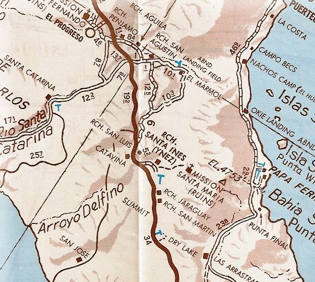
Things really sprung up once the transpeninsular highway was opened (Dec. 1, 1973). The town of Cataviña did not exist before the pavement, for
example. It began as a 'Parador' facility to serve the new traffic and included a Pemex station Cafeteria with a sunken lounge, showers and restrooms.
Across the highway was an El Presidente hotel and just north, a trailer park campground. In July, 1973 there was none of that here and no road
construction had reached the spot yet. My next trip was in April, 1974 and all of the parador was in operation. Naturally these services needed people
to operate them, and the nearby ranchos of San Luis and Santa Ynez did not have people for hire.
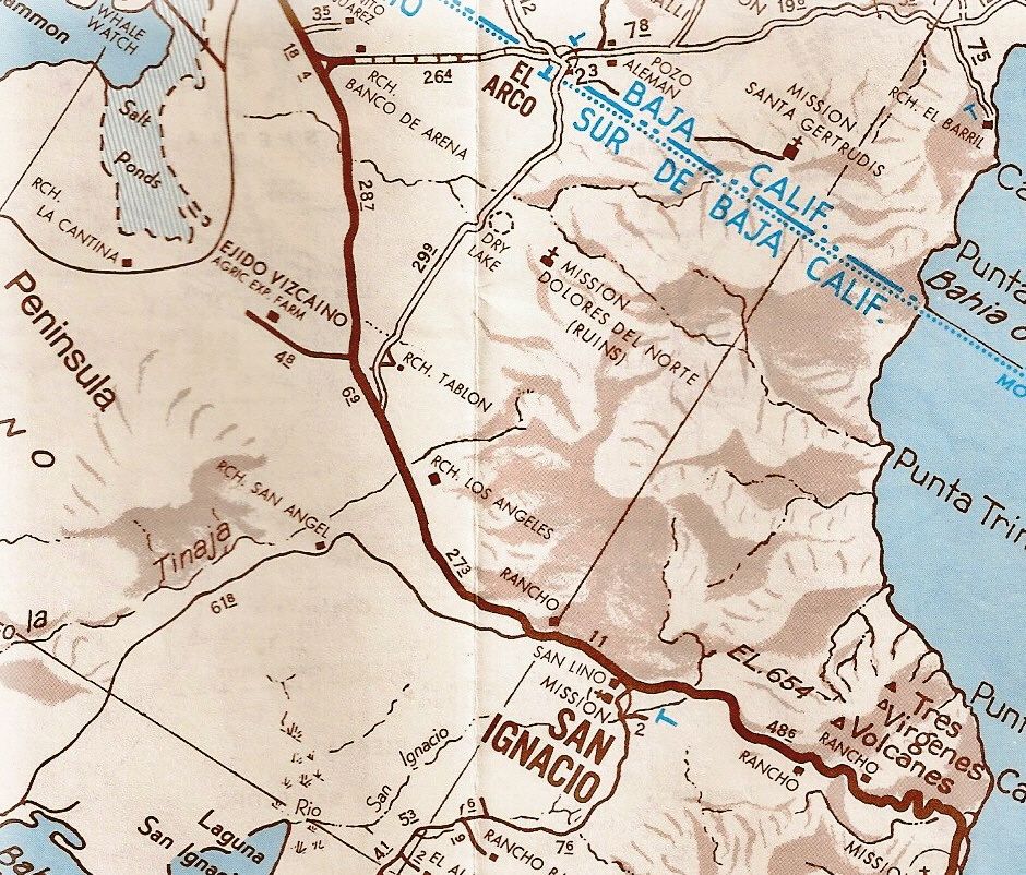
The other 'new' town I can think of is Vizcaino (El Vizcaino)... It sprung up from the desert just before the new highway arrived. Nearby, the pilot
test farm project known as Rancho de Wilson was successful in using 'fossil water' to turn the desert into a food producing oasis. Rancho de Wilson
was started about 1959. On today's topo map, it is called 'Pueblo Viejo'. The name of a town or ejido of 'Vizcaino' first began about 2 miles east of
where it is today. The business opportunity from truck, bus and auto traffic on Hwy. 1 was just too great. The original Ejido Vizcaino became Ejido
Diaz Ordaz and a new Highway One 'Vizcaino' exploded with growth.
In the 1972 Auto Club guide to Baja California Sur, the pavement going north had reached midway between Santa Rosalia and San Ignacio with roadbed
construction on to San Ignacio and beyond an additional 10 miles west (or northbound). In that guide, El Vizcaino is first mentioned as being a
recently developed agricultural community, 5 miles west of Rancho El Tablon.
On these 1974 Auto Club maps of the two areas it is clear that Cataviña is just a minor point along the highway and Vizcaino was well west of the
highway and didn't exist at the junction with the Asuncion/ Tortugas road as of yet.
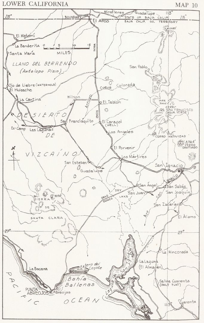
Here is the 1962 Gulick Map showing Rancho de Wilson:
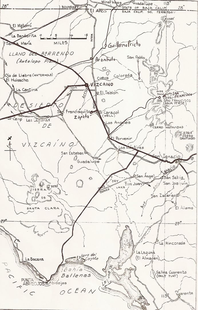
Now here is that map with new additions drawn in to show the location comparison:
What are any other 'new' towns that popped up?
[Edited on 1-15-2014 by David K]
|
|
|
Udo
Elite Nomad
Posts: 6364
Registered: 4-26-2008
Location: Black Hills, SD/Ensenada/San Felipe
Member Is Offline
Mood: TEQUILA!
|
|
Mil gracias for that bit of information. I had always wondered about the farm west of Vizcaino...and now I know.
[Edited on 1-15-2014 by Udo]
Udo
Youth is wasted on the young!
|
|
|
DJL
Junior Nomad
Posts: 95
Registered: 11-9-2013
Member Is Offline
|
|
Timely info , Mr. K. !!
I was sitting around last Night , pouring over my copy of " Baja California" , from the Time-Life book series ... published in 1972 (Right - what kind
of person comes in from a 6+ week trip to Baja , only to start reading about Baja immediately ?) and noticed no mention of Catavina anywhere in it .
We were wondering ....
D.~
|
|
|
Baja Bucko
Nomad
Posts: 288
Registered: 9-23-2003
Member Is Offline
|
|
And now Vizcaino is the cesspool gathering spot for the cartel and other similar buddies alive and well.......
My other 4WD is a Baja Mule!
La Mula Mil Survivor 2013-2014!
1000 miles by mule from the tip to Tecate!
|
|
|
BajaDQ
Newbie
Posts: 18
Registered: 1-13-2014
Location: SW Colorado
Member Is Offline
Mood: Sunny
|
|
I did not know that about Vizcaino Bucko. What issues has that created for the locals and the area?
DQ
|
|
|
Baja Bucko
Nomad
Posts: 288
Registered: 9-23-2003
Member Is Offline
|
|
MAJOR BIG issues for the innocent family members whose lives are touched whether in the 2nd degree or 6th degree of separation.
If you are poor and making very little sweeping the street and you get offered $1000 to carry a package from point A to B, do you turn it down? It
is easy for someone who is not lacking money to say no and mind their own business but easy money becomes the knell of death sooner or later and these
guys do not walk away. Nobody ever leaves.....it is a one way ticket for the family and close folks.
I have a couple of friends who are cops south of GN and all I keep telling them is find a another job away from this mess.
My other 4WD is a Baja Mule!
La Mula Mil Survivor 2013-2014!
1000 miles by mule from the tip to Tecate!
|
|
|
David K
Honored Nomad
Posts: 65509
Registered: 8-30-2002
Location: San Diego County
Member Is Offline
Mood: Have Baja Fever
|
|
| Quote: | Originally posted by Baja Bucko
And now Vizcaino is the cesspool gathering spot for the cartel and other similar buddies alive and well....... |
Mama Espinoza warned us in 1973 that "Bad Roads bring Good People", BUT that "GOOD ROADS BRING ALL KINDS OF PEOPLE"!
|
|
|
BajaDQ
Newbie
Posts: 18
Registered: 1-13-2014
Location: SW Colorado
Member Is Offline
Mood: Sunny
|
|
| Quote: | | Mama Espinoza warned us in 1973 that "Bad Roads bring Good People", BUT that "GOOD ROADS BRING ALL KINDS OF PEOPLE"! |
I've heard that quote many times David, and it's so true. It's unfortunate, but there may be an upswing of cartel activity in the areas North of
Gonzaga , added to what's possibly already there.
Looks like my question took this thread OT, sorry for that. Your OP and question is an interesting one.
|
|
|
David K
Honored Nomad
Posts: 65509
Registered: 8-30-2002
Location: San Diego County
Member Is Offline
Mood: Have Baja Fever
|
|
Well some thread sidebars can be more popular than the original topic. So no more new towns? Guayaquil is not much older. It didn't exist in the mid
1960s.
|
|
|
DavidE
Ultra Nomad
Posts: 3814
Registered: 12-1-2003
Location: Baja California México
Member Is Offline
Mood: 'At home we demand facts and get them. In Mexico one subsists on rumor and never demands anything.' Charles Flandrau,
|
|
For a long time Guerrero Negro was known as a major stolen car and chop shop paradise.
Mulas will always be a problem. Today it's mota, when that gets legalized, then coca, tuba, then whatever else. A thousand dollars? You must be
joking. Try $3,000 MN.
A Lot To See And A Lot To Do
|
|
|
TMW
Select Nomad
Posts: 10659
Registered: 9-1-2003
Location: Bakersfield, CA
Member Is Offline
|
|
I always thought Guayaquil was a ranch not a town. Never been down to it just saw it passing by.
|
|
|
durrelllrobert
Elite Nomad
Posts: 7393
Registered: 11-22-2007
Location: Punta Banda BC
Member Is Offline
Mood: thriving in Baja
|
|
Not in CENTERAL baja but an interesting NEW town
NEW URUAPAN
The town of New Uruapan is located in the Municipality of Ensenada (in the State of Baja California). It has 789 inhabitants. New Uruapan is 30
meters of altitude.
In the town there are 406 men and 383 women. The relationship women/men is 0,943 . The ratio of fertility of the female population is 3.09 children
per woman. The illiteracy rate among adults is 3.3 % (3.45 % in men and 3.13 % in women) and the degree of schooling is 6.65 (6.48 in men and 6.84 for
women).
In New Uruapan the 1.77 % of the adults spoke an indigenous language. In the town are 212 houses, of which the 4.69 % are equipped with a computer.
Bob Durrell
|
|
|
DavidE
Ultra Nomad
Posts: 3814
Registered: 12-1-2003
Location: Baja California México
Member Is Offline
Mood: 'At home we demand facts and get them. In Mexico one subsists on rumor and never demands anything.' Charles Flandrau,
|
|
Any idea of the percentage of homes of 2 or more persons with a capilla of la virgen de Guadalupe on the living room wall?
A Lot To See And A Lot To Do
|
|
|
David K
Honored Nomad
Posts: 65509
Registered: 8-30-2002
Location: San Diego County
Member Is Offline
Mood: Have Baja Fever
|
|
| Quote: | Originally posted by TW
I always thought Guayaquil was a ranch not a town. Never been down to it just saw it passing by. |
Maybe a ranch in size now, but ...
In 1972 it was a settlement of 50-80 people and had a deligación municipal (de El Mármol)....
This is from Arnold Senterfitt's Airports of Baja:
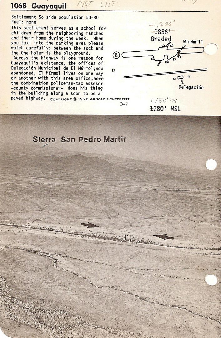
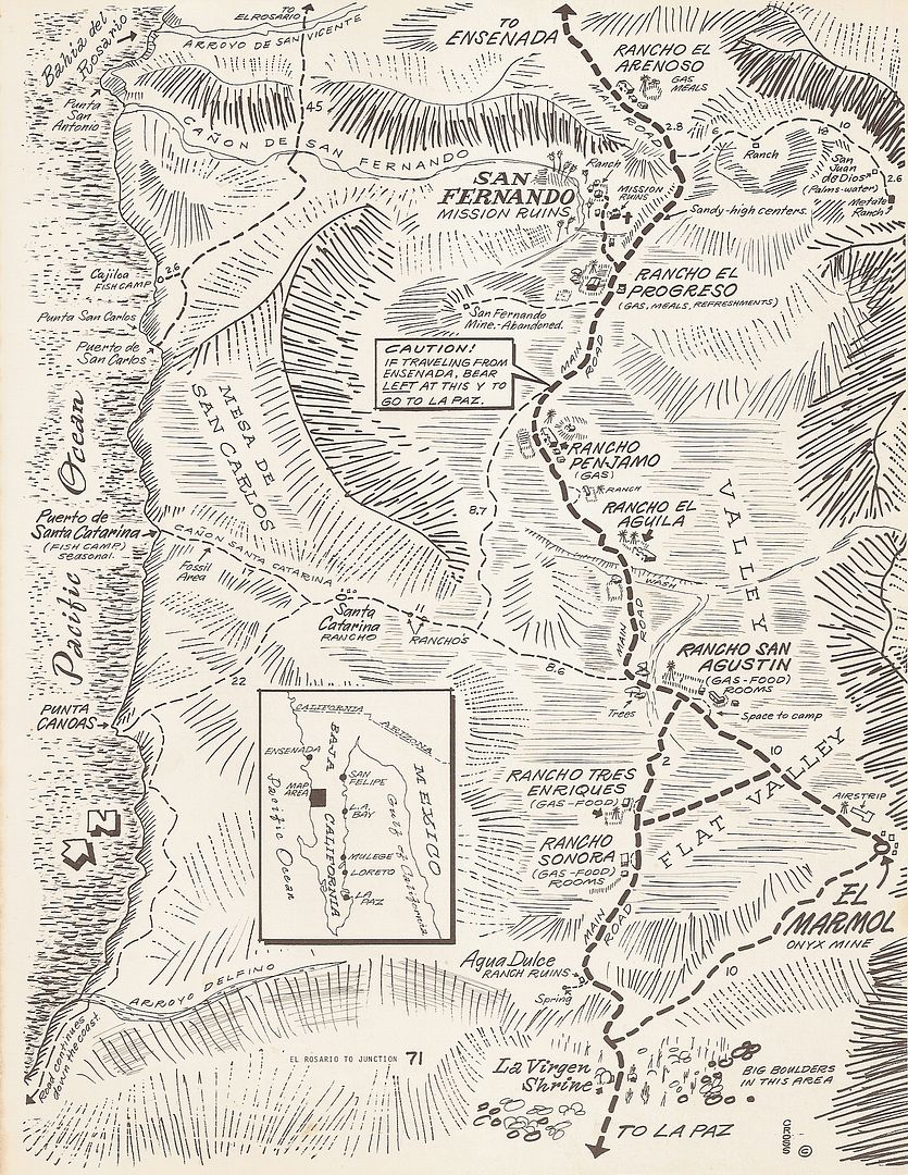
Pretty new, as it didn't exist as more than a unnamed ranch in Cliff Cross' 1970 book, with his bird's eye view maps. It was created between Penjamo
and El Aguila:
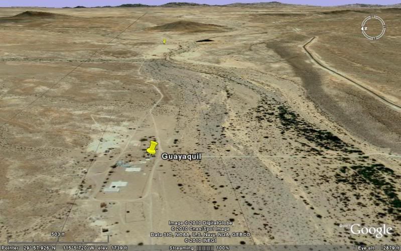
Here it is on Google Earth, looking east (note they built the highway over on the hill south of town, robbing it of the future prosperity hoped for in
1972.
[Edited on 1-15-2014 by David K]
|
|
|
MikeYounghusband
Nomad
Posts: 213
Registered: 8-27-2008
Location: Loreto, Baja Cal. Sur
Member Is Offline
Mood: Always ready for more
|
|
You know Dave, if we wait a little while we just might see a new town with a new name pop up at the LA Bay turn off. It's growing bigger each year.
|
|
|
David K
Honored Nomad
Posts: 65509
Registered: 8-30-2002
Location: San Diego County
Member Is Offline
Mood: Have Baja Fever
|
|
Good Post!
| Quote: | Originally posted by MikeYounghusband
You know Dave, if we wait a little while we just might see a new town with a new name pop up at the LA Bay turn off. It's growing bigger each year.
|
Maybe? Originally that was 'Parador Punta Prieta' (named for the small town about 7 miles south), and like the other paradors it was built to serve
the new travelers on Hwy. 1. It had a Pemex station, cafeteria, sunken lounge area, restrooms, showers, a trailer park/ campground, but NO hotel.
Management of the Pemex failed, and so the facility closed up except for the trailer park and a new junk yard across the highway. Gasoline has been
sold by independent vendors in front of the abandoned parador for many years now.
What other businesses are there now?
|
|
|
MikeYounghusband
Nomad
Posts: 213
Registered: 8-27-2008
Location: Loreto, Baja Cal. Sur
Member Is Offline
Mood: Always ready for more
|
|
There is a tienda, restaurant and mechanic and maybe more
|
|
|
Bajahowodd
Elite Nomad
Posts: 9274
Registered: 12-15-2008
Location: Disneyland Adjacent and anywhere in Baja
Member Is Offline
|
|
| Quote: | Originally posted by David K
Not so old history question that it belongs in the Baja History & Literature forum, but was thinking of what towns didn't exist before 1972 (the
year pavement reached north to Santa Rosalia from La Paz, and south to Colonia V. Guerrero/San Quintin from Ensenada.
Things really sprung up once the transpeninsular highway was opened (Dec. 1, 1973). The town of Cataviña did not exist before the pavement, for
example. It began as a 'Parador' facility to serve the new traffic and included a Pemex station Cafeteria with a sunken lounge, showers and restrooms.
Across the highway was an El Presidente hotel and just north, a trailer park campground. In July, 1973 there was none of that here and no road
construction had reached the spot yet. My next trip was in April, 1974 and all of the parador was in operation. Naturally these services needed people
to operate them, and the nearby ranchos of San Luis and Santa Ynez did not have people for hire.
The other 'new' town I can think of is Vizcaino (El Vizcaino)... It sprung up from the desert just before the new highway arrived. Nearby, the pilot
test farm project known as Rancho de Wilson was successful in using 'fossil water' to turn the desert into a food producing oasis. Rancho de Wilson
was started about 1959. On today's topo map, it is called 'Pueblo Viejo'. The name of a town or ejido of 'Vizcaino' first began about 2 miles east of
where it is today. The business opportunity from truck, bus and auto traffic on Hwy. 1 was just too great. The original Ejido Vizcaino became Ejido
Diaz Ordaz and a new Highway One 'Vizcaino' exploded with growth.
In the 1972 Auto Club guide to Baja California Sur, the pavement going north had reached midway between Santa Rosalia and San Ignacio with roadbed
construction on to San Ignacio and beyond an additional 10 miles west (or northbound). In that guide, El Vizcaino is first mentioned as being a
recently developed agricultural community, 5 miles west of Rancho El Tablon.
On these 1974 Auto Club maps of the two areas it is clear that Cataviña is just a minor point along the highway and Vizcaino was well west of the
highway and didn't exist at the junction with the Asuncion/ Tortugas road as of yet.
Here is the 1962 Gulick Map showing Rancho de Wilson:
Now here is that map with new additions drawn in to show the location comparison:
What are any other 'new' towns that popped up?
[Edited on 1-15-2014 by David K] |
The Presidente hotel chain was chosen by the federal government to build and operate the hotels along the new Route 1. In later itterations, they
became LA Pinta and Desert Inn.
|
|
|
David K
Honored Nomad
Posts: 65509
Registered: 8-30-2002
Location: San Diego County
Member Is Offline
Mood: Have Baja Fever
|
|
Correct, new hotels were built at:
Parador San Quintin (west of the highway's parador, on the beach near Cielito Lindo. When the highway was moved because of repeated flood washouts,
the parador died.
Parador Santa Ines/Cataviña (once Cataviña was established after the highway was built and known, the Santa Ines part of the name was dropped).
Parador Paralelo 28º (Eagle Monument, north of Guerrero Negro). This was the most elaborate of the new El Presidente hotels. Maybe because the
president opened the highway here on Dec. 1, 1973? Of interest, when driven in July 1973 (pavement had reached well north to Punta Prieta) past this
point, there was no traffic circle or monument under construction. That was all done after July and before Dec. 1!
Parador San Ignacio. The hotel was built close to town, a mile off the highway in the palms, most beautiful.
Those four locations took care of the newest section of Hwy. 1. The El Presidente chain also purchased the Playas de Loreto hotel, which was already
established.
|
|
|
Bajahowodd
Elite Nomad
Posts: 9274
Registered: 12-15-2008
Location: Disneyland Adjacent and anywhere in Baja
Member Is Offline
|
|
Is that how that hotel in Loreto became a La Pinta/ Desert Inn? I have thought for years that that particular property, with its long beachfront was
an ideal candidate for remodeling into something more upscale.
|
|
|
| Pages:
1
2 |


