| Pages:
1
2 |
Whale-ista
Super Nomad

Posts: 2011
Registered: 2-18-2013
Location: San Diego
Member Is Offline
Mood: Sunny with chance of whales
|
|
Conversations with border crossing agents: #1- Otay Mesa
Me: (after being waived thru) Next time, how do I enter the ReadiLanes instead of the regular lanes when I approach this crossing?
Him: I have no idea. You've been to Mexico at least one time more than me.
\"Probably the airplanes will bring week-enders from Los Angeles before long, and the beautiful poor bedraggled old town will bloom with a
Floridian ugliness.\" (John Steinbeck, 1940, discussing the future of La Paz, BCS, Mexico)
|
|
|
dasubergeek
Senior Nomad
Posts: 694
Registered: 8-17-2013
Member Is Offline
|
|
Figures!
When you head west on Blvd. Industrial (from Blvd. 2000), don't turn right for the regular lanes. Keep going and make a right on Vía de la Juventud
Ote. (signs will point you to the airport). Then turn right at El Negro Durazo and stay to the left side as you head down that street. It'll dump you
out into the left side of the Otay border road, which is where the Ready Lanes are.

|
|
|
Whale-ista
Super Nomad
Posts: 2011
Registered: 2-18-2013
Location: San Diego
Member Is Offline
Mood: Sunny with chance of whales
|
|
thank you!
And now I need to figure out how to get to Blvd. 2000 after crossing SB...I get lost every time.
\"Probably the airplanes will bring week-enders from Los Angeles before long, and the beautiful poor bedraggled old town will bloom with a
Floridian ugliness.\" (John Steinbeck, 1940, discussing the future of La Paz, BCS, Mexico)
|
|
|
bajaguy
Elite Nomad
Posts: 9247
Registered: 9-16-2003
Location: Carson City, NV/Ensenada - Baja Country Club
Member Is Offline
Mood: must be 5 O'clock somewhere in Baja
|
|
Two turns
When you clear Mexican Customs proceed straight for 1 mile. At the first stoplight (Industrial Blvd) turn left onto Industrial.
Proceed 5 miles on Industrial to the Junction of Corridor 2000, take the right turn onto Corridor 2000
|
|
|
bajaguy
Elite Nomad
Posts: 9247
Registered: 9-16-2003
Location: Carson City, NV/Ensenada - Baja Country Club
Member Is Offline
Mood: must be 5 O'clock somewhere in Baja
|
|
I thought you turned right onto Humboldt from Juventud for a line-up to the Ready lane???
| Quote: | Originally posted by dasubergeek
Figures!
When you head west on Blvd. Industrial (from Blvd. 2000), don't turn right for the regular lanes. Keep going and make a right on Vía de la Juventud
Ote. (signs will point you to the airport). Then turn right at El Negro Durazo and stay to the left side as you head down that street. It'll dump you
out into the left side of the Otay border road, which is where the Ready Lanes are.
|
|
|
|
David K
Honored Nomad
Posts: 65509
Registered: 8-30-2002
Location: San Diego County
Member Is Offline
Mood: Have Baja Fever
|
|
| Quote: | Originally posted by bajaguy
When you clear Mexican Customs proceed straight for 1 mile. At the first stoplight (Industrial Blvd) turn left onto Industrial.
Proceed 5 miles on Industrial to the Junction of Corridor 2000, take the right turn onto Corridor 2000 |
It is crazy well signed for TECATE CUOTA (Toll), MEXICALI CUOTA, MEX 2 or 2-D, and then CORREDOR 2000, POPOTLA/ ROSARITO.
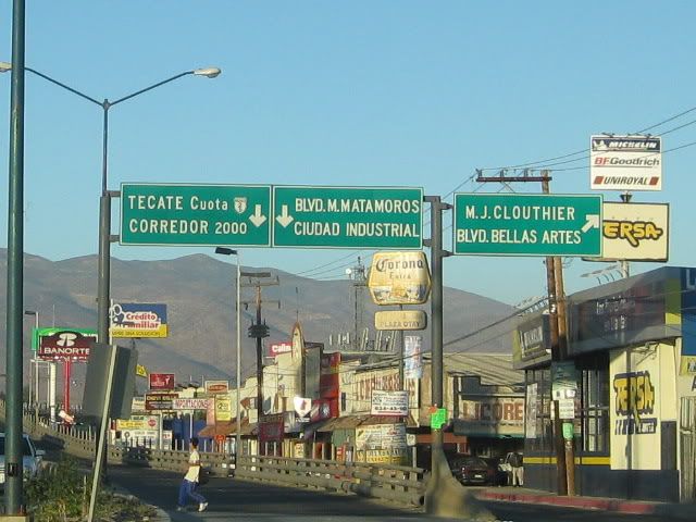
Here the sun glare is over "ROSARITO" where you turn right to the CORREDOR 2000 (straight is the Tecate/ Mexicali toll highway)...
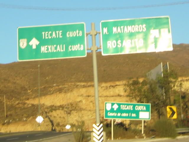
What a great road!:
|
|
|
dasubergeek
Senior Nomad
Posts: 694
Registered: 8-17-2013
Member Is Offline
|
|
| Quote: | Originally posted by bajaguy
I thought you turned right onto Humboldt from Juventud for a line-up to the Ready lane??? |
Yes. El Negro Durazo is at the corner of Juventud and Alejandro Humboldt. That is the route depicted on the map.
|
|
|
Pescador
Ultra Nomad
Posts: 3587
Registered: 10-17-2002
Location: Baja California Sur
Member Is Offline
|
|
| Quote: | Originally posted by dasubergeek
Figures!
When you head west on Blvd. Industrial (from Blvd. 2000), don't turn right for the regular lanes. Keep going and make a right on Vía de la Juventud
Ote. (signs will point you to the airport). Then turn right at El Negro Durazo and stay to the left side as you head down that street. It'll dump you
out into the left side of the Otay border road, which is where the Ready Lanes are.
|
I want a good copy of that map.
|
|
|
Ateo
Elite Nomad
Posts: 5950
Registered: 7-18-2011
Member Is Offline
|
|
What's the name of the street you turn right on from Industrial to get to the Sentri? Or landmark.
|
|
|
Udo
Elite Nomad
Posts: 6364
Registered: 4-26-2008
Location: Black Hills, SD/Ensenada/San Felipe
Member Is Offline
Mood: TEQUILA!
|
|
A good copy of the map is not necessary, Jim.
Your normal turn to the crossing is at the treffic light where the tire shop is.
Just go to the next traffic light, and make a right. Then go north one long block and make a right again.
The readylane traffic generally starts somewhere near that area. If you are lucky and get there when traffic is light, just travel the length of the
block (eastbound), and turn left at the first left turn.
The map you are looking at just complicates things.
Just remember: Right at next block past tire shop, right, right, then left.
Could not get any simpler than that.
Udo
| Quote: | Originally posted by Pescador
| Quote: | Originally posted by dasubergeek
Figures!
When you head west on Blvd. Industrial (from Blvd. 2000), don't turn right for the regular lanes. Keep going and make a right on Vía de la Juventud
Ote. (signs will point you to the airport). Then turn right at El Negro Durazo and stay to the left side as you head down that street. It'll dump you
out into the left side of the Otay border road, which is where the Ready Lanes are.
|
I want a good copy of that map. |
Udo
Youth is wasted on the young!
|
|
|
bajaguy
Elite Nomad
Posts: 9247
Registered: 9-16-2003
Location: Carson City, NV/Ensenada - Baja Country Club
Member Is Offline
Mood: must be 5 O'clock somewhere in Baja
|
|
Udo.......
If the Tijuana police traffic cops are there, they MAY turn you around as your route intersects with the established Ready Lane traffic on
Humboldt........I know from experience.
Better to go the long was as depicted on the map.
| Quote: | Originally posted by Udo
A good copy of the map is not necessary, Jim.
Your normal turn to the crossing is at the treffic light where the tire shop is.
Just go to the next traffic light, and make a right. Then go north one long block and make a right again.
The readylane traffic generally starts somewhere near that area. If you are lucky and get there when traffic is light, just travel the length of the
block (eastbound), and turn left at the first left turn.
The map you are looking at just complicates things.
Just remember: Right at next block past tire shop, right, right, then left.
Could not get any simpler than that.
Udo
| Quote: | Originally posted by Pescador
| Quote: | Originally posted by dasubergeek
Figures!
When you head west on Blvd. Industrial (from Blvd. 2000), don't turn right for the regular lanes. Keep going and make a right on Vía de la Juventud
Ote. (signs will point you to the airport). Then turn right at El Negro Durazo and stay to the left side as you head down that street. It'll dump you
out into the left side of the Otay border road, which is where the Ready Lanes are.
|
I want a good copy of that map. |
|
|
|
|
Pescador
Ultra Nomad
Posts: 3587
Registered: 10-17-2002
Location: Baja California Sur
Member Is Offline
|
|
Yep, exactly, I got turned away on Monday, President's Day Weekend at San Ysidro and when I tried to get to Otay, it is a confusing mess, to say the
least, and of course when I hit the normal entrance, they turned me away there because traffic was backed up to far. So I paid the stupid toll, went
to Tecate and then had to drive 94 late at night, in the dark, with frustrated drivers pushing me down the mountain.
I think it may be easier to just go out in the desert and sneak across with the drug smugglers. 
|
|
|
wessongroup
Platinum Nomad
Posts: 21152
Registered: 8-9-2009
Location: Mission Viejo
Member Is Offline
Mood: Suicide Hot line ... please hold
|
|
Might be quicker in some cases ... 
|
|
|
durrelllrobert
Elite Nomad
Posts: 7393
Registered: 11-22-2007
Location: Punta Banda BC
Member Is Offline
Mood: thriving in Baja
|
|
I understand that once the Otay Mesa East POE is complete Corridor (Blvd) 2000 will become a toll road and be extended to pass over the Tecate/
Mexicalli toll road and go directly to the new crossing which takes you to CA SR11 (also a toll road) that will connect with SR 905 and SR 125. No
more going up the Avenida Internacional hill. Construction has started on the US side and construction on the Mexican side starts mañana ?.
Bob Durrell
|
|
|
Whale-ista
Super Nomad
Posts: 2011
Registered: 2-18-2013
Location: San Diego
Member Is Offline
Mood: Sunny with chance of whales
|
|
So much construction going on, thanks for the updates. If you are a "frequent flyer" across the border I suppose it all makes sense. For those of us
not travelling as often....confusing.
A few observations/questions:
As I waited at Tecate last week, I saw a sign promising "ReadyLane Proximamente". We shall see...
Regarding tolls: Blvd. 2000 is already a toll road, isnt it? I paid a toll in January, leaving Hwy 1 at Popotla heading NE to Otay. So, are you saying
the price will increase? And will it only go to the "Lexus lane" at the Otay border?
If it means a more direct route to the crossing, I won't mind avoiding the urban/coastal traffic. But would prefer the ReadyLane vs. Lexus toll
crossing.
\"Probably the airplanes will bring week-enders from Los Angeles before long, and the beautiful poor bedraggled old town will bloom with a
Floridian ugliness.\" (John Steinbeck, 1940, discussing the future of La Paz, BCS, Mexico)
|
|
|
Pescador
Ultra Nomad
Posts: 3587
Registered: 10-17-2002
Location: Baja California Sur
Member Is Offline
|
|
You were actually paying the toll for your section of Ensenada - Tijuana toll road used, not for Avenida 2000.
|
|
|
Whale-ista
Super Nomad
Posts: 2011
Registered: 2-18-2013
Location: San Diego
Member Is Offline
Mood: Sunny with chance of whales
|
|
thank you Pescador- that makes sense.
Now I understand why, when I left the road to head to the Otay crossing, no toll was collected.
If I had continued to Tecate, via the tollroad, I recall from doing this in 2012 that it would have been rather expensive.
\"Probably the airplanes will bring week-enders from Los Angeles before long, and the beautiful poor bedraggled old town will bloom with a
Floridian ugliness.\" (John Steinbeck, 1940, discussing the future of La Paz, BCS, Mexico)
|
|
|
David K
Honored Nomad
Posts: 65509
Registered: 8-30-2002
Location: San Diego County
Member Is Offline
Mood: Have Baja Fever
|
|
Folks it is CORREDOR 2000... and it is a FREE highway... the toll leaving Hwy. 1-D at Popotla northbound is for the section of Hwy.
1-D you were just on and would have had to pay for just a couple miles ahead on 1-D... as Pescador said.
|
|
|
David K
Honored Nomad
Posts: 65509
Registered: 8-30-2002
Location: San Diego County
Member Is Offline
Mood: Have Baja Fever
|
|
| Quote: | Originally posted by Whale-ista
thank you Pescador- that makes sense.
Now I understand why, when I left the road to head to the Otay crossing, no toll was collected.
If I had continued to Tecate, via the tollroad, I recall from doing this in 2012 that it would have been rather expensive. |
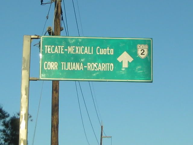
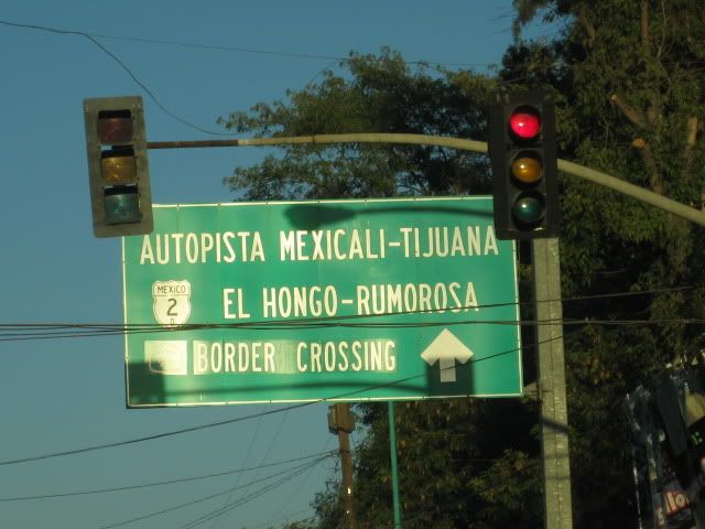
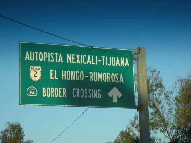
To go to Tecate from the Corredor 2000, I recommend exiting onto the Tecate FREE highway (Mex. 2)... It is a 4 lane road and only a couple stops in La
Florida where you first get onto it. When you enter Tecate, just follow the many signs for Mexicali and San Diego, as the border road is on the
Mexicali side of Tecate.
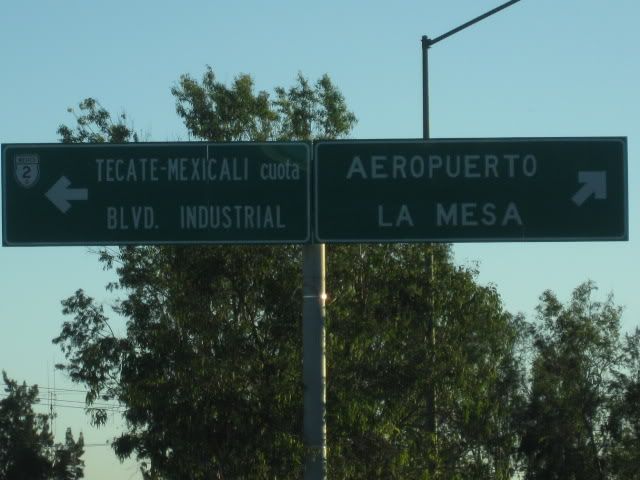
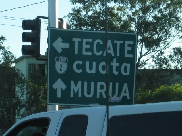
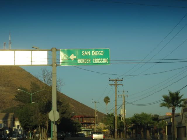
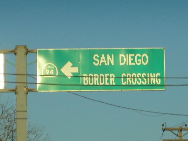
Here are some of the signs after leaving the Corredor 2000 and using the Tecate FREE road to get to the border:
|
|
|
dasubergeek
Senior Nomad
Posts: 694
Registered: 8-17-2013
Member Is Offline
|
|
| Quote: | Originally posted by Pescador
I want a good copy of that map. |
U2U me your e-mail address. I'm sure I have the higher-res lying around (I was the one who created the map.)
|
|
|
| Pages:
1
2 |


