4x4abc
Ultra Nomad

Posts: 4455
Registered: 4-24-2009
Location: La Paz, BCS
Member Is Offline
Mood: happy - always
|
|
Camino Real
Is there any documentation from the time of construction of the Camino Real? In the Jakob Baegert letters there are tidbits found between the lines -
and that's it.
Is there maybe documentation from other areas where the Jesuits have built roads?
Is there anything contemporary aside from Crosbys Kings Highway and Gulicks lost notes? Any studies done by research groups? Anything from INAH?
Does anyone here know more about the supporting Ranchos?
(OK, I have saved my text this time, in case it gets eaten by the software again)
[Edited on 1-4-2015 by 4x4abc]
Harald Pietschmann
|
|
|
TMW
Select Nomad
Posts: 10659
Registered: 9-1-2003
Location: Bakersfield, CA
Member Is Offline
|
|
Is this a quiz for DavidK?
|
|
|
David K
Honored Nomad
Posts: 65480
Registered: 8-30-2002
Location: San Diego County
Member Is Offline
Mood: Have Baja Fever
|
|
Harald, until Doug fixes the forum, you have to remove all accent marks and tildes of the n for a post to show.
I am naturally looking forward to what you want to share!
Here are my maps and Google Earth shots of the Jesuit El Camino Real posted on Nomad: http://vivabaja.com/missions2/page13.html
|
|
|
4x4abc
Ultra Nomad
Posts: 4455
Registered: 4-24-2009
Location: La Paz, BCS
Member Is Offline
Mood: happy - always
|
|
do I need to be female, naked and attacked by car thieves?
Harald Pietschmann
|
|
|
bajabuddha
Banned
Posts: 4024
Registered: 4-12-2013
Location: Baja New Mexico
Member Is Offline
Mood: Always cranky unless medicated
|
|
Naw, just an old wimman with shriveled testicles.

[Edited on 1-6-2015 by bajabuddha]
I don't have a BUCKET LIST, but I do have a F***- IT LIST a mile long!
86 - 45*
|
|
|
David K
Honored Nomad
Posts: 65480
Registered: 8-30-2002
Location: San Diego County
Member Is Offline
Mood: Have Baja Fever
|
|
Glad you got the post to work Harald.
First, the answer is yes, the padres did write about their roads. The Jesuit, Ignacio Lizasoain made a very detailed itinerary in 1761-1762 of his
travel on the road to document the missions and visitas. It contains distances and road conditions, along with place names.
Junipero Serra's diary of his journey from Loreto to San Diego (1769) gives many descriptions.
Americans in 1849 traveling to Alta Califronia gold fields used the Camino Real and wrote about it.
The first place to read about the road is (the link above): http://www.sandiegohistory.org/journal/77winter/baja.htm
From San Javier to San Borja, much of the Jesuit road can be seen easily on Google Earth where modern road building hasn't destroyed it.
San Borja to Santa Maria, most of the road is no more than a cow trail in appearances. The Jesuits were the master engineers and road builders. They
simply didn't have time to build the road to their specifications before be forced off the peninsula in 1768.
The Franciscans or Dominicans were not the road builders of the Jesuits quality, and while Serra did order the Camino Real be moved out of the Santa
Maria canyon and a direct cargo trail from Gonzaga Bay for San Fernando and Alta California needs, it was not much more than an animal track. From
near Santa Maria to El Rosario, we know the route but seeing it from space was not possible due to vegetation, lack of grading or straight alignments
that are easier to spot.
I did find what I believe was the Camino Real near El Rosario (near the road to Pta. San Carlos, south of Km. 80. Have a look: http://vivabaja.com/1104/page5.html
From that page:
To find this piece of El Camino Real, take Mexico Highway 1 to Km. 80+ (almost K-81) about 14 miles from El Rosario.
There is a sharp curve to the left and here a wide dirt road turns off to the right (south). This is the road to Punta San Carlos (36 mi.).
Go just 0.5 mi. and turn right on the dirt road going west. Go 1.4 miles on this road and park. You are on top of the ECR route.
The Camino Real hike begins at 30 01.167', 115 33.260' (map datum NAD27 Mex.) elev. 973'. The old trail goes straight towards El Rosario (northwest).
I hiked about a mile of it in November, 2004. For more on El Camino Real and maps of it's route, see http://vivabaja.com/ECR
|
|
|
wetto
Nomad
Posts: 119
Registered: 10-28-2013
Location: Grass Valley, CA / Mulege
Member Is Offline
|
|
Thanks for the San Diego History Link.
good stuff.
Lee S
|
|
|
David K
Honored Nomad
Posts: 65480
Registered: 8-30-2002
Location: San Diego County
Member Is Offline
Mood: Have Baja Fever
|
|
My pleasure... there are more such links in my web page: http://vivabaja.com and I am happy to post historical data and location details here on Nomad. See the Baja Nomad Historical Interests and
Literature forum for tons of great stuff, as well.
|
|
|
David K
Honored Nomad
Posts: 65480
Registered: 8-30-2002
Location: San Diego County
Member Is Offline
Mood: Have Baja Fever
|
|
Want to see the Camino Real from space?
I have a page with links to satellite images and maps of the Jesuit Road in Baja. Here is what is listed on the page that are clickable links:
EL CAMINO REAL (satellite images and maps)
ECR-1 Santa Maria to San Borja
ECR-2a San Borja to Santa Gertrudis (Sierra route)
ECR-2b San Borja to Santa Gertrudis (Golfo route)
ECR-3a Santa Gertrudis to San Ignacio (Pacifico route)
ECR-3b Santa Gertrudis to San Ignacio (Sierra route)
ECR-4 San Ignacio to Guadalupe
ECR-5 Guadalupe to Comondu
ECR-6 Comondu to Loreto
HARRY CROSBY's 1977 ECR Notes and Maps
HOWARD GULICK's 1954 ECR Maps
Here is the page with those links: http://vivabaja.com/missions2/page13.html
|
|
|
David K
Honored Nomad
Posts: 65480
Registered: 8-30-2002
Location: San Diego County
Member Is Offline
Mood: Have Baja Fever
|
|
Just got word of the actual ECR route near Coco's Corner (Calamajué to Las Arrastras/San Francisquito section) by someone who has been hiking the
actual trail with historic documentation as a guide.
When viewed on Google Earth, the Camino Real can be seen going northward from the old Calamajué runway (west of the auto road and north of the mill
ruins). It vanishes and I presumed it soon crossed through a canyon to the west to the desert south of Coco's and headed north to Las Arrastras. You
can pick up bits of the trail north of the ranch that is west of Coco's. The new highway construction is basically on top of that trail section.
The new information says it keeps going north from where it vanishes on Google Earth, parallels the auto road to Mission Calamajué (from Coco's) and
goes through a small north/south running canyon before crossing the auto road and then heads west to Las Arrastras. I am told bits of the mission road
can be seen while doing the easy hike north from Calamajué.
ECR is shown with red arrows here starting at the Calamajué airport symbol:
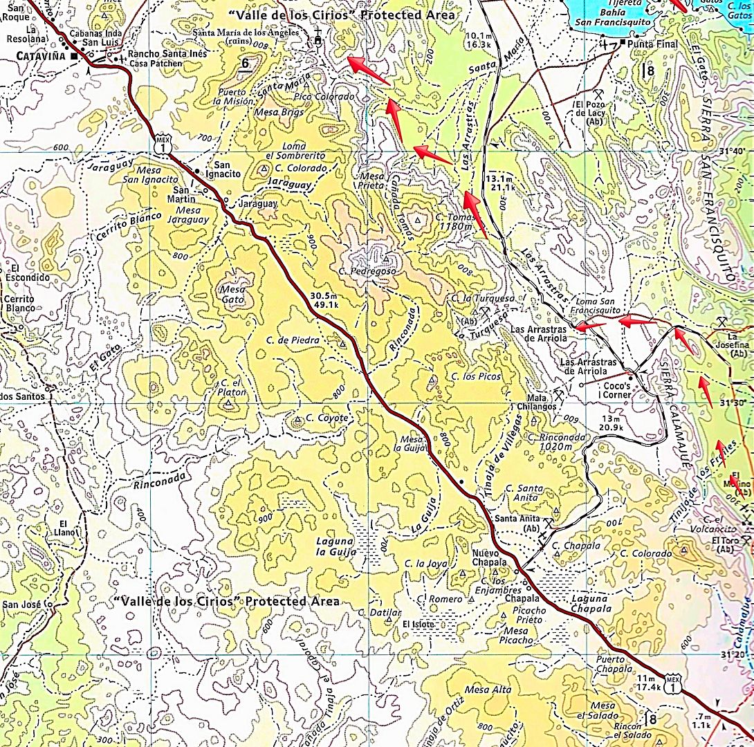
[Edited on 11-29-2022 by David K]
|
|
|
PaulW
Ultra Nomad
Posts: 3113
Registered: 5-21-2013
Member Is Offline
|
|
From map above the INEGI topos would be H11D49 el Crucero, H11d39 Calamajue, H11D29 Pt Final, and just west of pt Final is H11D28 Jaraguay. Just west
of Calamajue is H11D38
Some roads are shown on these maps. As usual not as clear as the Almanac. I was hoping for more clarity?
|
|
|
David K
Honored Nomad
Posts: 65480
Registered: 8-30-2002
Location: San Diego County
Member Is Offline
Mood: Have Baja Fever
|
|
You were hoping for more clarity in what, my map or the Inegi maps?
|
|
|


