| Pages:
1
2 |
John M
Super Nomad

Posts: 1924
Registered: 9-3-2003
Location: California High Desert
Member Is Offline
|
|
La Turquesa Road
Has anyone driven the la Turquesa route since the SCORE race used that route a couple of years ago?
John M
[Edited on 11-26-2022 by John M]
|
|
|
David K
Honored Nomad
Posts: 65549
Registered: 8-30-2002
Location: San Diego County
Member Is Offline
Mood: Have Baja Fever
|
|
Last year, was it not?
I read that Allan of Baja Overlanding on Facebook drove it in a lifted Jeep, as I recall? Rough, of course.
Now, since Hurricane Kay is anyone's guess.
You can simply go back to Hwy. 5 if washed out.
|
|
|
John M
Super Nomad
Posts: 1924
Registered: 9-3-2003
Location: California High Desert
Member Is Offline
|
|
Thanks DK
If we try it, we will be going from the Highway 1 side to Highway 5.
First hand experience would be great.
JM
|
|
|
David K
Honored Nomad
Posts: 65549
Registered: 8-30-2002
Location: San Diego County
Member Is Offline
Mood: Have Baja Fever
|
|
I sent him a private message.
|
|
|
steekers
Nomad
Posts: 257
Registered: 12-4-2007
Member Is Offline
|
|
Most likely I will go for it on my moto, but start from Coco's going up the grade to Mex 1 either this month or early next year before the heat.
Anyone else interested, message me. Once getting to Mex 1, we meet our shuttle to Santa Ynez for camping, then do the full Mission trail and Oasis,
and maybe a Pacific run and back.
|
|
|
David K
Honored Nomad
Posts: 65549
Registered: 8-30-2002
Location: San Diego County
Member Is Offline
Mood: Have Baja Fever
|
|
Quote: Originally posted by steekers  | | Most likely I will go for it on my moto, but start from Coco's going up the grade to Mex 1 either this month or early next year before the heat.
Anyone else interested, message me. Once getting to Mex 1, we meet our shuttle to Santa Ynez for camping, then do the full Mission trail and Oasis,
and maybe a Pacific run and back. |
Sound like a great adventure!
After Hurricane Kay, there may be some difficulty in crossing the valley floor between the turquoise mine and the bottom of the grade. You may ask
your shuttle to wait at Coco's for a bit, should you need to turn back and not ride the highway so far?
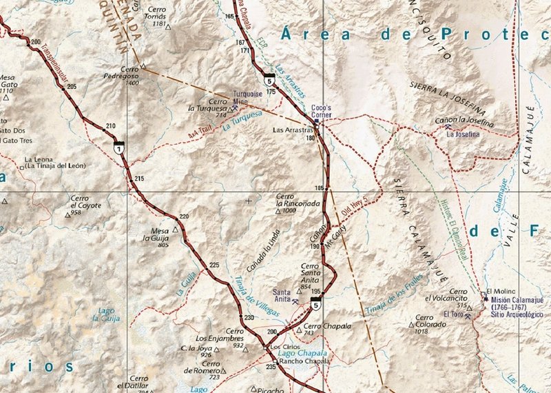
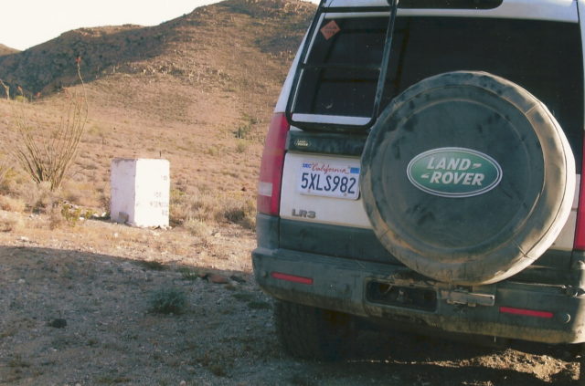
Map is from the 2021 Benchmark Baja California Road & Recreation Atlas:
[Edited on 12-1-2022 by David K]
|
|
|
PaulW
Ultra Nomad
Posts: 3113
Registered: 5-21-2013
Member Is Offline
|
|
I remember when I first heard about the trail when I was at Tony's Baja 250 party, back when, and was sitting at the table with Tom (TMW) and he told
me with driving instructions how to find the trail. He said it was the first time he had done the grade.
Then I had to get out my Almanac to see what it showed. Now we have much better maps along with written instructions.
The map is great.
|
|
|
David K
Honored Nomad
Posts: 65549
Registered: 8-30-2002
Location: San Diego County
Member Is Offline
Mood: Have Baja Fever
|
|
Just chatted with him. He didn't run it as had originally planned. His Intel was it's only passable west to east.
Looking forward to Steelers discoveries!
Do you remember the first Nomad to drive up the grade? It was 'The Square Circle' (Roy) in his LR3 with help from TMW and his brother. Many photos of
that historic event... I can add.
|
|
|
bajatrailrider
Ultra Nomad
Posts: 2551
Registered: 1-24-2015
Location: Mexico
Member Is Offline
Mood: Happy
|
|
We rode motos long before SC did it 3 times up it. First time gal on back of my moto. The hard part was before up hill only boulders lose the size of
basket balls. I could not handle that big bike with her on back. She ran the whole distance to start of up hill. It was a handful two up but I made
it. Be nice to get info of recent anybody going up. We may join you guys
|
|
|
David K
Honored Nomad
Posts: 65549
Registered: 8-30-2002
Location: San Diego County
Member Is Offline
Mood: Have Baja Fever
|
|
| Quote: Originally posted by bajatrailrider | | We rode motos long before SC did it 3 times up it. First time gal on back of my moto. The hard part was before up hill only boulders lose the size of
basket balls. I could not handle that big bike with her on back. She ran the whole distance to start of up hill. It was a handful two up but I made
it. Be nice to get info of recent anybody going up. We may join you guys |
Are you talking about La Turquesa?
'steekers' would like another m/c rider along.
[edited because auto correct on my phone chaged Steekers to Steelers]
[Edited on 12-2-2022 by David K]
|
|
|
David K
Honored Nomad
Posts: 65549
Registered: 8-30-2002
Location: San Diego County
Member Is Offline
Mood: Have Baja Fever
|
|
La Turquesa Grade and the Nomads
I first went to examine it on President's Day weekend 2007:
https://vivabaja.com/p207/

Between Km. 213 and 214, south of the El Pedregoso boulder hill, this rocky track heads east. GPS: 29°31.15′, -114°30.03′(WGS84). This is 97
miles south of El Rosario and 12 1/2 miles north of Laguna Chapala.

The rocky track in the arroyo changes to a smoother road after a half mile or so… It is 4.6 miles from Hwy. 1 to the viewpoint at the top of the
grade… the peninsular divide.
La Turquesa Canyon View (29°32.54′, -114°26.06′)

The elevation here is 2,816′ and you can see all the way to the granite boulders where Hwy. 5 is located. The turquoise mine is on the left side of
the canyon.

Expecting to find just a trail down the mountain passable only to motorcycles, I was surprised to see this constructed grade heading down into the
canyon! Appears to be an old mine road. Later, we hear that Fred Hampe of Rancho Santa Ynez made it after failing to to to Punta Final (Gonzaga Bay)
after building the road to Mission Santa María, and two more miles beyond (early 1960s). Santa Ynez also owned Punta Final and seeked a short cut
between the two.

Hwy. 1 to Hwy. 5 is about 11 miles. We now know what the west 6 miles look like. On the east end, a road comes about 3 miles from Highway 5, passes
the green pools and ends at the turquoise mine. See http://vivabaja.com/wayno and http://vivabaja.com/1102/ for photos and GPS.
Following this report, Nomads 'steekers' went and photographed the grade from the turquoise mine and Ken Cooke, with other Jeeps, tried to get to it
from the mine. The brush and cactus on the valley floor made finding a route difficult and required much hacking to reopen the abandoned auto road
that had been here.
May 2008, Roy ('The squarecircle') climbs the grade with help from TMW and others to find a path west from the turquoise mine to the foot of
the grade:
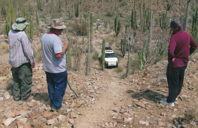
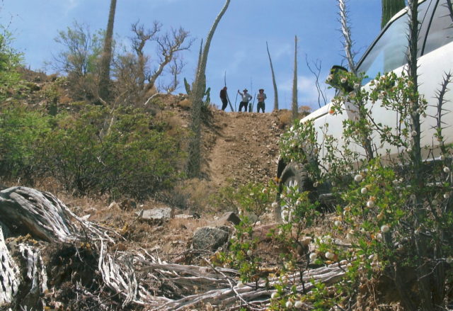

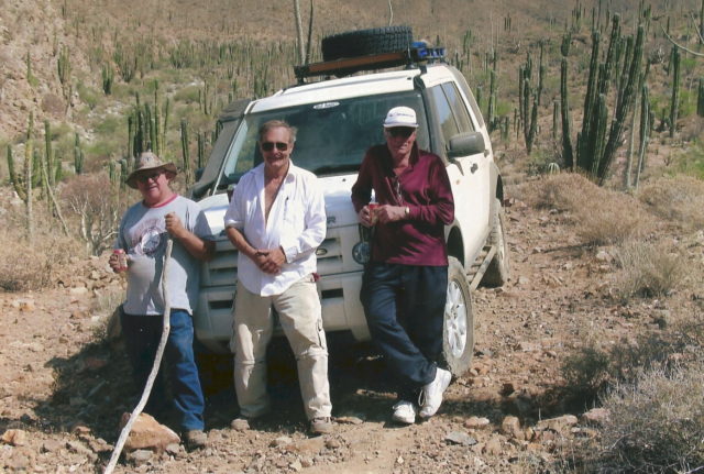
TMW on the left and Roy in the center
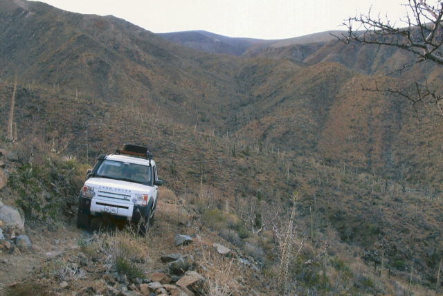
Land Rover LR3 climbing the grade.
Reaching the top of the grade. Was this the first four-wheeled vehicle to do so in 30 years???
Motorcycles have been using it and it was one of the trip detailed in Kacey Smith's 2001 GPS guide for motor bikes, as the 'XR Ride Up' also known as
Coco's Shortcut.
In 2021, the Baja 1000 used it, and the Benchmark Baja Atlas showed it as a 4x4 trail.
Now you know the rest of the story!   
|
|
|
TMW
Select Nomad
Posts: 10659
Registered: 9-1-2003
Location: Bakersfield, CA
Member Is Offline
|
|
If Roy had a locker in the rear it would have been much easier for him. He took about 3 runs at it. Lots of loose rock on that hill.
|
|
|
David K
Honored Nomad
Posts: 65549
Registered: 8-30-2002
Location: San Diego County
Member Is Offline
Mood: Have Baja Fever
|
|
Hmmm, it did have a traction control, as he climbed the Widowmaker easily. He does fiddle with factory equipment so maybe he disabled it,
accidentally?
|
|
|
TMW
Select Nomad
Posts: 10659
Registered: 9-1-2003
Location: Bakersfield, CA
Member Is Offline
|
|
He may have, I just know he was throwing rocks every which way from his rear wheels.
|
|
|
David K
Honored Nomad
Posts: 65549
Registered: 8-30-2002
Location: San Diego County
Member Is Offline
Mood: Have Baja Fever
|
|
Ya, I did see that in the photos at the bottom up to where you were standing.
Traction control will spin just briefly, then brake those spinning tires to put the traction tires to work at moving the vehicle.
Lowering the air pressure will also help.
The whole process is an art, one learns with trial and error.
The advanced systems, like Toyota's A-Trac, provides locker-like traction on all four corners.
|
|
|
fishmugger
Newbie
Posts: 11
Registered: 9-5-2014
Location: San Deigo
Member Is Offline
|
|
Cocos short cut
Did it last year in February in a rzr 1000. Took about 2 to 3 hours . Can’t remember but one rough ass road. Believe me it’s no short cut . Glad I
did it but never again
|
|
|
mtgoat666
Platinum Nomad
Posts: 21063
Registered: 9-16-2006
Location: San Diego
Member Is Offline
Mood: Hot n spicy
|
|
| Quote: Originally posted by David K | Ya, I did see that in the photos at the bottom up to where you were standing.
Traction control will spin just briefly, then brake those spinning tires to put the traction tires to work at moving the vehicle.
Lowering the air pressure will also help.
The whole process is an art, one learns with trial and error.
The advanced systems, like Toyota's A-Trac, provides locker-like traction on all four corners.
|
Helps to use a lighter vehicle with upsized/wider tires.
That Range Rover with stockish size tires ain’t set up for offroad, and will cause erosion. Your Toyota with a-crack is also sort of of on the
heavy side for offroad.
All you adventurers in full size pickups are offroad posers, vehicles are too heavy for off-roading.
Woke!
Hands off!
“Por el bien de todos, primero los pobres.”
“...ask not what your country can do for you – ask what you can do for your country.” “My fellow citizens of the world: ask not what America
will do for you, but what together we can do for the freedom of man.”
Pronoun: the royal we
|
|
|
David K
Honored Nomad
Posts: 65549
Registered: 8-30-2002
Location: San Diego County
Member Is Offline
Mood: Have Baja Fever
|
|
Roy replaced the stock tires with the largest size that he could fit.
I do not drive a full-size pickup. In fact, only for two years of my off-roading were with a 'full-size'. 1975-1977, I owned a Jeep Cherokee Chief.
After getting rid of that beast, which was constantly breaking down (had a 401 V-8), I got a (1.6 liter, H-4) Subaru 4WD Wagon, the first of three
(the third one had a 1.8 liter H-4 engine). In 2000, I got my first of three Toyota Tacoma 4x4s (V-6).
|
|
|
bajaric
Senior Nomad
Posts: 681
Registered: 2-2-2015
Member Is Offline
|
|
Tell that to the Mexican ranchers... A full size truck with a long wheelbase can get across ruts that would high center a smaller vehicle. I have
had my 2WD F-150 with stock road tires in some gnarly places, the aluminum body and small ecoboost engine make it light and nimble, though soft sand
is its downfall.
A couple years ago I drove part way up the Turquesa road from Hwy. 5. At that time the new highway was paved but not yet open and traffic was still
on the old dirt road. Access to the Turquesa road was under a bridge with yellow guard rails, up a steep slope. Not sure where the route used by
SCORE departs the new highway. The bridge was a little north (not south) of a similar bridge at the new Cocos, which, I think, is at Las Arrastras.
Beautiful pristine area with lots of cardon and elephant trees
edit: the bridge I drove under was a little NORTH of the Bridge at the new Cocos, here: 29.5718 -114.3662. At that time the road off the paved
highway was inaccessible so the road under the bridge was a bypass.
[Edited on 12-4-2022 by bajaric]
|
|
|
David K
Honored Nomad
Posts: 65549
Registered: 8-30-2002
Location: San Diego County
Member Is Offline
Mood: Have Baja Fever
|
|
Km. 176 is the Turquesa Canyon road, and the new Coco's Corner is Km. 179.5, next to Las Arrastras, which you can see from the long bridge just north
of Km. 180. The 2021 Baja 1000 left the highway just north of Coco's about Km. 179.
|
|
|
| Pages:
1
2 |


