| Pages:
1
2
3
..
5 |
mtgoat666
Select Nomad

Posts: 17438
Registered: 9-16-2006
Location: San Diego
Member Is Offline
Mood: Hot n spicy
|
|
Hurricane Hilary
New storm brewing... not yet named, but should soon be Hilary. The NWS is saying likely to feed moisture to San Diego region this weekend, maybe even
an inch of rain in san diego, say the forecasters. Here is NHC narrative...
ZCZC MIATWOEP ALL
TTAA00 KNHC DDHHMM
Tropical Weather Outlook
NWS National Hurricane Center Miami FL
500 PM PDT Tue Aug 15 2023
For the eastern North Pacific...east of 140 degrees west longitude:
Active Systems:
The National Hurricane Center is issuing advisories on Hurricane
Fernanda, located several hundred miles west-southwest of the
southern tip of the Baja California peninsula.
1. Off the Coast of Southwestern Mexico (EP90):
Showers and thunderstorms are beginning to show signs of
organization in association with a broad area of low pressure
located a few hundred miles south of Acapulco, Mexico.
Environmental conditions appear conducive for continued development,
and a tropical depression or tropical storm is anticipated to form
within the next day or so. The system is expected to move
west-northwestward to northwestward, roughly parallel to the coast
of southwestern Mexico and the Baja California peninsula during the
next several days. Additional information on this system, including
gale warnings, can be found in High Seas Forecasts issued by the
National Weather Service.
* Formation chance through 48 hours...high...90 percent.
* Formation chance through 7 days...high...90 percent.
https://www.nhc.noaa.gov/gtwo.php?basin=epac&fdays=2

[Edited on 8-17-2023 by mtgoat666]
Woke!
“...ask not what your country can do for you – ask what you can do for your country.” “My fellow citizens of the world: ask not what America
will do for you, but what together we can do for the freedom of man.”
Prefered gender pronoun: the royal we
|
|
|
AKgringo
Elite Nomad
Posts: 5862
Registered: 9-20-2014
Location: Anchorage, AK (no mas!)
Member Is Online
Mood: Retireded
|
|
Tracking it on Windy, it looks like it will wash the length of the Baja Penninsula!
https://www.windy.com/?2023082015,27.294,-103.667,4,m:ej7ac3...
If you are not living on the edge, you are taking up too much space!
"Could do better if he tried!" Report card comments from most of my grade school teachers. Sadly, still true!
|
|
|
JZ
Elite Nomad
Posts: 9378
Registered: 10-3-2003
Member Is Offline
|
|
Time to grab the board and head to the Seven Sisters!!
|
|
|
Phil C
Senior Nomad
Posts: 564
Registered: 3-27-2004
Location: N. San Diego County/ Loreto Centro/Lopez Mateos
Member Is Offline
|
|
I love it when the peninsula gets drenched without major wind.
|
|
|
AKgringo
Elite Nomad
Posts: 5862
Registered: 9-20-2014
Location: Anchorage, AK (no mas!)
Member Is Online
Mood: Retireded
|
|
It is a bit early in the season for me, but I may have to make a run just to catch the bloom!
Of course there could also be a bloom of insects 
If you are not living on the edge, you are taking up too much space!
"Could do better if he tried!" Report card comments from most of my grade school teachers. Sadly, still true!
|
|
|
SFandH
Elite Nomad
Posts: 6961
Registered: 8-5-2011
Member Is Offline
|
|
The next 6 to 8 weeks is the time of the season.
|
|
|
Don Pisto
Banned
Posts: 1282
Registered: 8-1-2018
Location: El Pescador
Member Is Offline
Mood: weary like everyone else
|
|
at least Hilary is gonna miss rosarito's popular beachfest, its over
there's only two things in life but I forget what they are........
John Hiatt
|
|
|
RFClark
Super Nomad
Posts: 2361
Registered: 8-27-2015
Member Is Offline
Mood: Looking forward to 2024
|
|
Goat and SD might get hammered by this one!
|
|
|
mtgoat666
Select Nomad
Posts: 17438
Registered: 9-16-2006
Location: San Diego
Member Is Offline
Mood: Hot n spicy
|
|
000
WTPZ44 KNHC 162044
TCDEP4
Tropical Storm Hilary Discussion Number 2
NWS National Hurricane Center Miami FL EP092023
400 PM CDT Wed Aug 16 2023
Hilary has not changed much this afternoon. A large burst of
convection, with cloud top temperatures colder than -85 degrees C,
continues to obscure the low-level circulation and some outflow has
developed on the southern semicircle of the storm. Subjective and
objective satellite intensity estimates range from 30 to 43 kt and
the initial intensity is remains at 35 kt.
The storm is moving to the west-northwest at 13 kt. Hilary is
forecast to gradually turn, first to the northwest by day 2 and
then to the north-northwest by day 3 with the same general forward
motion. This is likely driven by a building ridge over the United
States and a trough off the coast of California. The short-term
track prediction has shifted to the right of the previous forecast,
largely due to an adjustment in the rather uncertain initial
position. It is closest to the simple consensus aid, TVCE.
Strengthening is still expected due to the conducive atmospheric
conditions and warm sea surface temperatures. Hilary is forecast to
be in an area of weak vertical wind shear through 72-96 hours and
remain over warm waters through 72 hours. Therefore, steady to
rapid intensification is anticipated and the official forecast
shows Hilary becoming a hurricane in 24 hours. However, the system
is broad and it could take slightly longer to initially consolidate
and strengthen. Beyond day 3, Hilary is forecast to cross over a
gradient of cooling ocean waters which should induce a weakening
trend. The system is still expected to be post-tropical by the end
of the forecast period.
[Edited on 8-17-2023 by mtgoat666]
Woke!
“...ask not what your country can do for you – ask what you can do for your country.” “My fellow citizens of the world: ask not what America
will do for you, but what together we can do for the freedom of man.”
Prefered gender pronoun: the royal we
|
|
|
AKgringo
Elite Nomad
Posts: 5862
Registered: 9-20-2014
Location: Anchorage, AK (no mas!)
Member Is Online
Mood: Retireded
|
|
Our local weather report is saying that the storm remnants might bring an extremely rare mid-summer rainfall to my area in Nevada County.
I wish it was here now, a lightning strike started a fire on highway 20 near the town of Washington. Mandatory evacuations are underway, but I think
the air and ground attacks are making good progress!
If you are not living on the edge, you are taking up too much space!
"Could do better if he tried!" Report card comments from most of my grade school teachers. Sadly, still true!
|
|
|
AKgringo
Elite Nomad
Posts: 5862
Registered: 9-20-2014
Location: Anchorage, AK (no mas!)
Member Is Online
Mood: Retireded
|
|
There is a fire department within a half mile of my house, and a fire hydrant across the street from my driveway.
The property I frequently talk about is ten miles from where I live. It would be more than I could handle if a fire came through parts of it!
[Edited on 8-17-2023 by AKgringo]
If you are not living on the edge, you are taking up too much space!
"Could do better if he tried!" Report card comments from most of my grade school teachers. Sadly, still true!
|
|
|
RFClark
Super Nomad
Posts: 2361
Registered: 8-27-2015
Member Is Offline
Mood: Looking forward to 2024
|
|
Lencho,
I ‘ve been through 2 wildfires that burned over where I lived. Generally there are a few things you can do in advance, but leave quickly with your
valuables is my advice.
The top picture is about 15 min before the fire reached our house. This was the 3rd fire that this house survived. The 2nd picture is the after
picture.
This fire was not strongly wind driven but it actually rained burning bits and pieces that spread the fire. I used the emergency water to put out
burning stuff after the fire passed (about 20 min).
The things made of metal came through the best. All the trees behind the house in the 1st picture burned.


|
|
|
Santiago
Ultra Nomad
Posts: 3501
Registered: 8-27-2003
Member Is Offline
|
|
Funny hijack - yesterday I told my partner, who has family in SD, that it looked like Hillary was going to affect California. A staunch republican, he
blurted out, "Oh god, is she running again?"
|
|
|
mtgoat666
Select Nomad
Posts: 17438
Registered: 9-16-2006
Location: San Diego
Member Is Offline
Mood: Hot n spicy
|
|

Tropical Storm Hilary Discussion Number 4
NWS National Hurricane Center Miami FL EP092023
300 AM MDT Thu Aug 17 2023
Hilary is a large tropical storm. An elongated band of deep
convection curves around the southern and eastern side of the
circulation, and a Central Dense Overcast has begun to develop due
to new convection near Hilary's center, with possibly the formative
stages of an eye. Subjective Dvorak estimates from TAFB and SAB
have jumped to a consensus T3.5/55 kt, and given the improved
satellite presentation since 06 UTC, the initial intensity is set at
60 kt.
Hilary is moving toward the west-northwest (300/11 kt), to the south
of a mid-tropospheric high stretching from the U.S. Rockies
southward into northern Mexico. The ridge is expected to shift
eastward to the Central Plains during the next 48 hours, while a
mid- to upper-level low moves eastward to the California coast. This
steering pattern evolution should cause Hilary to recurve toward the
northwest and then north during the next 3 days. Model guidance is
in generally good agreement on Hilary's future path, with a fairly
tightly packed guidance envelope for much of the forecast period.
Therefore, the new NHC track forecast is very close to a blend of
the previous forecast with the HFIP Corrected Consensus aid (HCCA)
and the TVCE consensus. Despite the high confidence in the track,
Hilary's oblique angle of approach to the west coast of the Baja
California peninsula does make it nearly impossible to know at this
point if the center will remain just offshore or move over the
peninsula before reaching the southwestern United States.
Negligible shear, very warm waters of 30 degrees Celsius, and
plentiful atmospheric moisture mean the environment is ripe for
Hilary to rapidly intensify during the next couple of days. In
fact, many of the SHIPS Rapid Intensification (RI) indices are
showing a 100 percent chance of RI during the next 48 hours. The
NHC intensity forecast follows this thinking and shows Hilary
becoming a hurricane very soon and then a major hurricane by tonight
or early Friday, more or less a blend of the HCCA aid and the SHIPS
solutions. Hilary should reach waters colder than 26 degrees
Celsius soon after 72 hours, and fast weakening is indicated after
that time, especially if the storm crosses over the Baja California
peninsula. The surface circulation is likely to be dissipated by
day 5, but a day 5 forecast point (as a remnant low) is still
provided to maintain a forecast track north of the Baja California
peninsula.
Area Forecast Discussion
National Weather Service San Diego CA
445 AM PDT Thu Aug 17 2023
.SYNOPSIS...
A low pressure system moving to near the California coast will
bring drier southwest flow aloft for today and Friday and begin to
spread cooling inland. For the weekend into early next week,
developing Hurricane Hilary is expected to bring a significant
surge of monsoonal and tropical moisture with widespread heavy
rainfall, especially for Sunday into Monday, and a high potential
for flash flooding in the mountains and deserts. Residual moisture
will maintain an active monsoon pattern through at least the
middle of next week with afternoon and evening thunderstorms in
the mountains, deserts, and inland valleys.
&&
.DISCUSSION...FOR EXTREME SOUTHWESTERN CALIFORNIA INCLUDING ORANGE...
SAN DIEGO...WESTERN RIVERSIDE AND SOUTHWESTERN SAN BERNARDINO
COUNTIES...
.
Tropical Storm Hilary is expected to become a hurricane today and
rapidly intensify into a major hurricane as it moves northward off
the Pacific coast of southern Baja, eventually tracking near the
Pacific coast or inland through northern Baja as it moves
northward.
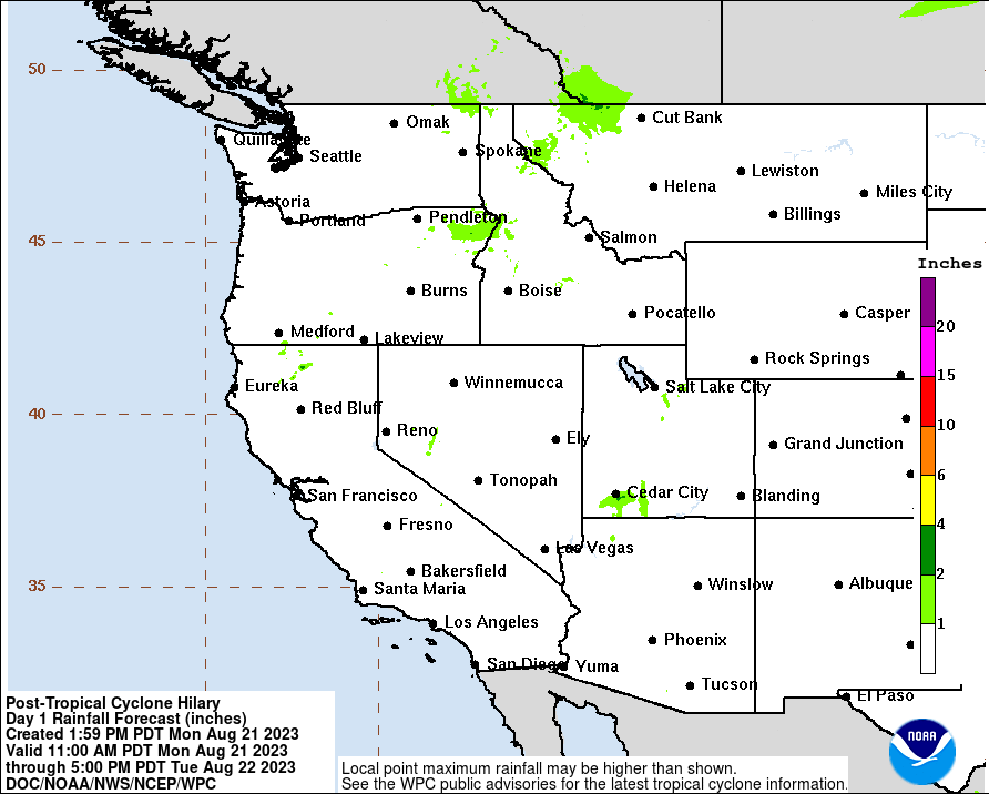
Regardless of the exact track, it will bring a substantial surge
of moisture into portions of southern California with a high
potential for heavy rainfall and flash flooding, especially for
the lower deserts into the adjacent mountains. The latest WPC
forecast has rainfall through Monday exceeding 5 inches for the
lower deserts into the adjacent mountains with 5 to 10 inches on
portions of the east slopes of the mountains. Potential wind
threats are less certain and more track dependent, generally
greater for a track a little farther west and less for a track a
little farther east.
Once this surge in moisture occurs, the moisture will be slow to
dissipate with an active monsoon pattern expected to persist
through at the least the middle of next week. NBM daily chances
of measurable rainfall at Big Bear remain above 30 percent through
Thursday of next week.
[Edited on 8-17-2023 by mtgoat666]
Woke!
“...ask not what your country can do for you – ask what you can do for your country.” “My fellow citizens of the world: ask not what America
will do for you, but what together we can do for the freedom of man.”
Prefered gender pronoun: the royal we
|
|
|
mtgoat666
Select Nomad
Posts: 17438
Registered: 9-16-2006
Location: San Diego
Member Is Offline
Mood: Hot n spicy
|
|
Big, big rains coming to northern half of baja peninsula and so cal…
Woke!
“...ask not what your country can do for you – ask what you can do for your country.” “My fellow citizens of the world: ask not what America
will do for you, but what together we can do for the freedom of man.”
Prefered gender pronoun: the royal we
|
|
|
Don Jorge
Senior Nomad
Posts: 639
Registered: 8-29-2003
Member Is Offline
|
|
Been a long time since the the river flowed bank to bank through Valle de Guadalupe.
There has been, to put it mildly, a bit of change in the area since the arroyo last raged. Development has encroached on the almost always dry
watercourse.
Almost always. Be interesting to see how this plays out.
Rain is always welcome, until it isn't.
�And it never failed that during the dry years the people forgot about the rich years, and during the wet years they lost all memory of the dry
years. It was always that way.�― John Steinbeck
"All models are wrong, but some are useful." George E.P. Box
"Nature bats last." Doug "Hayduke" Peac-ck
|
|
|
thebajarunner
Ultra Nomad
Posts: 3687
Registered: 9-8-2003
Location: Arizona....."Free at last from crumbling Cali
Member Is Offline
Mood: muy amable
|
|
Send it our way, por favor!!
Our usual monsoons have been all dry so far
Lots of wind (Monsoon means wind, not rain) and lots of tree damage but no rain
Last Summer the Greater Phoenix area had about 3 massive rain events.
This year, not a drip nor a drizzle.
And Monsoon Season typically ends here September 15
The saguaros are dropping arms to conserve internal moisture.
|
|
|
mtgoat666
Select Nomad
Posts: 17438
Registered: 9-16-2006
Location: San Diego
Member Is Offline
Mood: Hot n spicy
|
|
Quote: Originally posted by thebajarunner  | Send it our way, por favor!!
Our usual monsoons have been all dry so far
Lots of wind (Monsoon means wind, not rain) and lots of tree damage but no rain
Last Summer the Greater Phoenix area had about 3 massive rain events.
This year, not a drip nor a drizzle.
And Monsoon Season typically ends here September 15
The saguaros are dropping arms to conserve internal moisture. |
be careful what you wish for. Current forecast thinks maybe 5+ inches of rain on east side of baja, imperial valley-san felipe region. with a bit of
shift in storm track, phoenix could get slammed
[Edited on 8-17-2023 by mtgoat666]
Woke!
“...ask not what your country can do for you – ask what you can do for your country.” “My fellow citizens of the world: ask not what America
will do for you, but what together we can do for the freedom of man.”
Prefered gender pronoun: the royal we
|
|
|
AlanDavid90
Junior Nomad
Posts: 27
Registered: 11-12-2017
Member Is Offline
|
|
A disaster is coming...
|
|
|
BajaBlanca
Select Nomad
Posts: 13166
Registered: 10-28-2008
Location: La Bocana, BCS
Member Is Offline
|
|
I saw a video of La Paz - major flooding in the streets.
|
|
|
| Pages:
1
2
3
..
5 |


