| Pages:
1
2 |
ftrphb
Junior Nomad

Posts: 69
Registered: 10-6-2023
Member Is Offline
|
|
Map questions, navigation?
Papar maps phone maps, do phone app maps work outside of coverage?
|
|
|
David K
Honored Nomad
Posts: 65581
Registered: 8-30-2002
Location: San Diego County
Member Is Offline
Mood: Have Baja Fever
|
|
YES... I was just posting about the Benchmark Maps second edition (2023) now on the Avenza App... Needs no cell coverage... satellite tracks your
location as you move in Baja. It is great.
Posted yesterday: https://forums.bajanomad.com/viewthread.php?tid=99343
|
|
|
John M
Super Nomad
Posts: 1924
Registered: 9-3-2003
Location: California High Desert
Member Is Offline
|
|
Another option
We used on X off-road maps for Baja
https://www.onxmaps.com/offroad/trails/mx/baja-california
John M
|
|
|
BeachSeeker
Nomad
Posts: 146
Registered: 6-6-2023
Member Is Offline
|
|
Gaia has been a game changer for me. Offline satellite maps are a huge advantage when exploring remote areas.
The only complaint I have with Gaia is that it takes FOREVER to download offline maps. A 100MB map can take 15+ minutes.
|
|
|
StuckSucks
Super Nomad
Posts: 2376
Registered: 10-17-2013
Location: Pacific Plate
Member Is Offline
|
|
Right now I'm building a map of places I'd like to visit in Baja for our upcoming Baja 1000 trip. The map gets built on Caltopo, then imported to Gaia
which lives on an iPad in the truck dedicated to navigation. As BeachSeeker said, you can download maps to use off line there - similar to the Avenza
app but much more powerful, flexible.
|
|
|
JZ
Select Nomad
Posts: 14906
Registered: 10-3-2003
Member Is Offline
|
|
Gaia or Back Country Navigator (BCN) are best.
I build tracks on Google Earth and import them to BCN.
My Google Earth:
[Edited on 10-23-2023 by JZ]
|
|
|
bajaric
Senior Nomad
Posts: 682
Registered: 2-2-2015
Member Is Offline
|
|
Good advice above, to elaborate a little the Avenza app is an economical way to load a pretty good road map (Benchmark Atlas) on your phone or
GPS-enabled tablet. I would also add that it would not hurt to get one of the more recent AAA Baja maps published up until about 2000 on eBay. The
AAA paper maps are easy to read and since they actually drove the roads and logged the mileages between road junctions in some areas these are still
the most accurate maps for driving the main connecting dirt roads in the back country.
A low tech option is to "snip" the Google Earth satellite view and print it out, then mark the latitude and longitude coordinates for road junctions
and features of interest on it and use a handheld GPS and a compass to determine the correct route while in the field.
A discussion of the best maps to use for navigation in the back country is included in my new book The Gold Distracts of Northern Baja a History and
Travel Guide (Jens Tobias) available on Amazon.com --
|
|
|
geoffff
Senior Nomad
Posts: 721
Registered: 1-15-2009
Member Is Offline
|
|
Some do! Check before leaving town 
Even Google Maps has an option to download maps of an area for offline use.
[Edited on 10-23-2023 by geoffff]
|
|
|
geoffff
Senior Nomad
Posts: 721
Registered: 1-15-2009
Member Is Offline
|
|
I don't see much there in OnX for Baja. A few trails, but ... mostly just satellite imagery (?) Are you seeing more?
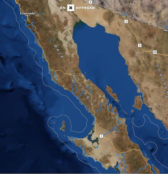
They do have Percebu as "Shell Beach" in there:

|
|
|
David K
Honored Nomad
Posts: 65581
Registered: 8-30-2002
Location: San Diego County
Member Is Offline
Mood: Have Baja Fever
|
|
Geoffff: Percebu is 6 kms north of the Shell Island driveway...
bajaric: the AAA Baja maps were made to 2010. See nearly all of them here: https://vivabaja.com/automobile-club-maps/
Okay, I am done being a map nerd today! LOL
|
|
|
Mulege Canuck
Nomad
Posts: 393
Registered: 11-27-2016
Member Is Offline
|
|
I use navionics app. I use it in BC for fishing. My IPad has GPS. I plot routes ahead of time. Works pretty well.
|
|
|
geoffff
Senior Nomad
Posts: 721
Registered: 1-15-2009
Member Is Offline
|
|
Other than Shell Island, I've been referring to the whole area as "Percebu", but I suppose I should specify Laguna Percebu or Estero Percebu, etc.

[Edited on 10-24-2023 by geoffff]
|
|
|
David K
Honored Nomad
Posts: 65581
Registered: 8-30-2002
Location: San Diego County
Member Is Offline
Mood: Have Baja Fever
|
|
Indeed... The campo is no longer named Laguna Percebu, but now Rancho Percebu... Seems like many campos have added 'Rancho' to their names... instead
of Campo or ? Maybe some kind of taxation advantage... like leaving rebar sticking up on roofs (unfinished homes are taxed at a lower rate)??
|
|
|
BeachSeeker
Nomad
Posts: 146
Registered: 6-6-2023
Member Is Offline
|
|
David, did you come up with the name "Shell Island"? I recently saw it listed as such on a Baja Real Estate website. They are trying to sell lots in
the lagoon area for pretty cheap. The land isn't really all that usable after the rain, or during a big high tide.
|
|
|
JZ
Select Nomad
Posts: 14906
Registered: 10-3-2003
Member Is Offline
|
|
I run Navonics on my phone for boating. Have been using it for 10+ years and it is fantastic. Garmin bought them several years back. They have a
Automated Route mode. Plug in start and end way points and it calculates routes that go around hazards. It shows your distance to the next way
point. Kinda like Google Maps for the water.
On the boat I also run two big Garmin GPS's. They have the same technology and call it Auto Guidance. I assume they incorporated this from Navonics.
[Edited on 10-25-2023 by JZ]
|
|
|
David K
Honored Nomad
Posts: 65581
Registered: 8-30-2002
Location: San Diego County
Member Is Offline
Mood: Have Baja Fever
|
|
Quote: Originally posted by BeachSeeker  | | David, did you come up with the name "Shell Island"? I recently saw it listed as such on a Baja Real Estate website. They are trying to sell lots in
the lagoon area for pretty cheap. The land isn't really all that usable after the rain, or during a big high tide. |
Yes, I named it that in 1978... of course almost nobody else would dare to drive over the lagoon mud flats to get to it, so hardly a chance for me to
share my idea for a gringo name. However, once I got onto the Internet, 25 years ago about, I called it that.
The gringos who moved into the area 20 or more year later, just called it Shell Beach... as it is a beach with lots of shells... a no brainer. Problem
is, there is already a popular place in Baja, by Punta Chivato, called Shell Beach. My name keeps this beach unique. Also, it is an island! At the
most extreme high tides, the sea water covers the mud/salt flats, surrounding the beach and making it a barrier island.
SEE THE PILOTS MAP:
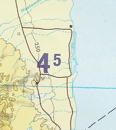
SEE THE NAT'L GEO. MAP:
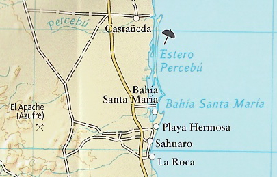
Looks more like an island than just a beach, does it not? LOL
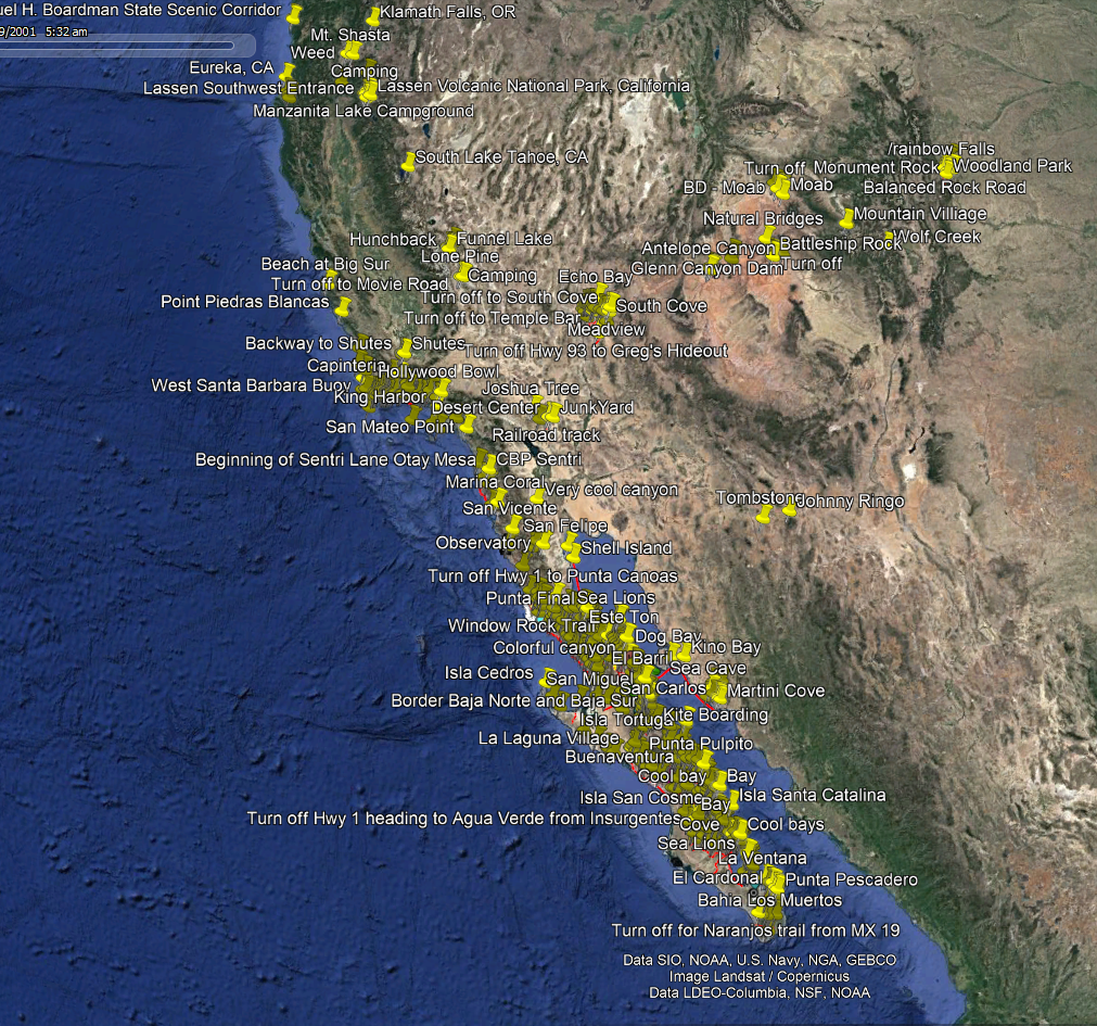
Enjoy my my LOCATIONS page for Shell Island photos, 1978 to 2018: https://vivabaja.com/shell-island/
I also named the steep grade near Mission Santa María, 'The Widowmaker', in 1999. Now it is universal in both Mexico and the U.S. Facebook
conversations. You can see my first webpage I made, in 1999 or 2000, about that trip and how Baja Mur and I both were tossed from our rides and shed
blood on the rocks there. "Widowmaker" was a natural choice! Here is that page from our 1999 trip where I called it The Widowmaker: https://vivabaja.com/missionsm/
Going to the mission, it is down the Widowmaker:

Leaving the mission, it is up the widowmaker. Photos are from my 5th time going, last year with TMW and other Nomads:

VIVA BAJA!
|
|
|
advrider
Super Nomad
Posts: 1924
Registered: 10-2-2015
Member Is Offline
|
|
OSMAND is my go-to on my phone, download a head of time for use with no service. Also have E32 maps on my GPS, they have a phone app as well.
Everything is color coded, so you know what kind of road it is. Easy to make a new route on the go.
|
|
|
ftrphb
Junior Nomad
Posts: 69
Registered: 10-6-2023
Member Is Offline
|
|
Any help for tried old abuelos that might try to use their phone to navigate? What if telephone navigation is new to me?
What are the best paper maps for a person with a 20 year old GPS?
|
|
|
JZ
Select Nomad
Posts: 14906
Registered: 10-3-2003
Member Is Offline
|
|
| Quote: Originally posted by ftrphb | Any help for tried old abuelos that might try to use their phone to navigate? What if telephone navigation is new to me?
What are the best paper maps for a person with a 20 year old GPS? |
This atlas:
https://www.amazon.com/Baja-California-Recreation-Atlas-Benc...
|
|
|
BeachSeeker
Nomad
Posts: 146
Registered: 6-6-2023
Member Is Offline
|
|
| Quote: Originally posted by geoffff |
I don't see much there in OnX for Baja. A few trails, but ... mostly just satellite imagery (?) Are you seeing more?
|
I just abandoned Gaia for OnX. Gaia has always had problems with downloading offline maps, and now I can't get it to finish downloading any maps
anymore. They are stuck at 100% but never complete. Functionally broken. Gaia has always been buggy, and customer support is nonexistent since they
sold the app.
My two main requirements are offline satellite maps and Carplay compatibility. OnX has both, and does it so much better than Gaia. Creating waypoints
and routes is just as easy as well. The only thing OnX doesn't have is topo maps, but with satellite, I never use topo anymore.
As far as predetermined trails, I turn all of that off. It might be good elsewhere, but there isn't much in Baja.
|
|
|
| Pages:
1
2 |


