| Pages:
1
2
3 |
4x4abc
Ultra Nomad

Posts: 4224
Registered: 4-24-2009
Location: La Paz, BCS
Member Is Offline
Mood: happy - always
|
|
parallel I run Google Earth and a separate set of INEGI topos on my laptop
mainly for the larger display
http://www.baja101.com/Baja-Topos.html

Harald Pietschmann
|
|
|
mtgoat666
Select Nomad
Posts: 17781
Registered: 9-16-2006
Location: San Diego
Member Is Offline
Mood: Hot n spicy
|
|
Does gaia use mapbox sat photos?
Does gaia allow you to interface with openstreetmap to save/share road/sites?
Woke!
“...ask not what your country can do for you – ask what you can do for your country.” “My fellow citizens of the world: ask not what America
will do for you, but what together we can do for the freedom of man.”
Prefered gender pronoun: the royal we
|
|
|
4x4abc
Ultra Nomad
Posts: 4224
Registered: 4-24-2009
Location: La Paz, BCS
Member Is Offline
Mood: happy - always
|
|
could not find those features
but GaiaGPS is so loaded now that it is hard to find what's in it.
Harald Pietschmann
|
|
|
David K
Honored Nomad
Posts: 64657
Registered: 8-30-2002
Location: San Diego County
Member Is Offline
Mood: Have Baja Fever
|
|
The Avenza App has the advantage of 'following you' as you travel in Baja, without any need for cell service. The zoom level also has an advantage
over the Benchmark book as it is lit and gives you a close look without needing a magnifying glass or reading glasses.
The detail or map scale is not as good as Inegi Topos, true. It sure will show you if you are on the right road or which fork to take.
I wish I had it in 2017, traveling south from Mission San Luis Gonzaga! While I did get to the La Pasión/ Dolores-2 mission that day, I didn't use
the road I had intended to. I followed the most worn or recent tracks, which is usually a good choice. Perhaps the road I took was better than the
maybe shorter route across the big arroyo of La Pasión (San Pedro on this map)?
I took the left fork at El Caporal, and the next fork after, rather than the right... and on this AAA map, showing my driving the two days before
arriving at your home, I drew in the the road that made that big northward loop. Arroyos point to the mission sites.
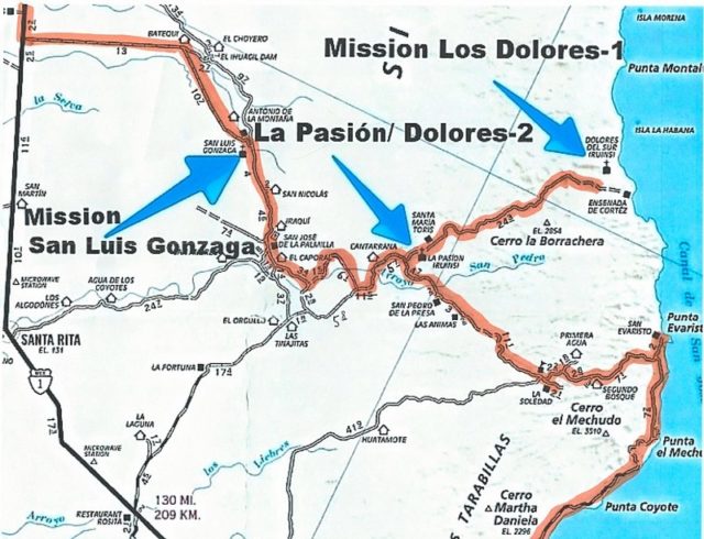
Photos on this page of my trip story: https://vivabaja.com/p817/2/
|
|
|
BeachSeeker
Nomad
Posts: 102
Registered: 6-6-2023
Member Is Offline
|
|
To me, offline satellite maps are a game changer for real exploration. Topo maps or the Avenza app are fine when you are just trying to get to towns
or fairly known areas. However, there is significant value in satellite maps when going to more remote areas.
I've used GaiaGPS successfully in the past, but downloading offline maps has always been painfully slow. Like leave your phone on all night, on wifi,
charging, just to download a few sections of satellite maps. Then recently the app completely stopped downloading offline maps. I've deleted and
reinstalled, nothing works. I messaged tech support, but I don't think the app is really supported anymore.
This last trip I switched to OnX Offroad. There are significantly less map options, but all I need is satellite. Downloads are super fast, and easy.
Apple CarPlay support is good. I'm a big fan.
|
|
|
4x4abc
Ultra Nomad
Posts: 4224
Registered: 4-24-2009
Location: La Paz, BCS
Member Is Offline
Mood: happy - always
|
|
Quote: Originally posted by David K  |
I wish I had it in 2017, traveling south from Mission San Luis Gonzaga! While I did get to the La Pasión/ Dolores-2 mission that day, I didn't use
the road I had intended to. I followed the most worn or recent tracks, which is usually a good choice. Perhaps the road I took was better than the
maybe shorter route across the big arroyo of La Pasión (San Pedro on this map)?
I took the left fork at El Caporal, and the next fork after, rather than the right... and on this AAA map, showing my driving the two days before
arriving at your home, I drew in the the road that made that big northward loop. Arroyos point to the mission sites.
|
The road at Rancho El Caporal is a good choice!
It has a much better Baja feel than the new wide government roads.
The "danger" of these new wide dirt highways the government built is that the locals no longer use the extensive historic road network.
By not using them any longer they fall into disrepair and become impassable.
We are losing access to the old Baja.
We are losing access to meeting the wonderful local people as the new roads are all designed to bypass the Ranchos.
That also creates a problem for the very detailed INEGI topos.
Many of the roads shown are impassable by now.
That also means that all map sources fall short of helping you to explore Baja.
I constantly run into dead ends. Thats is in addition to the Rancho created road blocks (the locals are no longer happy to see visitors).
Bottom line - you'll have to improvise and you may not get to where you wanted to go.
Harald Pietschmann
|
|
|
David K
Honored Nomad
Posts: 64657
Registered: 8-30-2002
Location: San Diego County
Member Is Offline
Mood: Have Baja Fever
|
|
Excellent advice, Harald!
|
|
|
4x4abc
Ultra Nomad
Posts: 4224
Registered: 4-24-2009
Location: La Paz, BCS
Member Is Offline
Mood: happy - always
|
|
update to Los Narajos road
a friend just came back from driving it
he descrided it as hard core off road
kinda manageable east to west
impossible west to east
Harald Pietschmann
|
|
|
HeyMulegeScott
Senior Nomad
Posts: 695
Registered: 8-25-2009
Location: Orygone/Mulege
Member Is Offline
|
|
Gaia uses Mapbox and Openstreet Map for sat with labels. It's a premium subscription along with the Mexican Topo layer. You can export any of your
saved data and also do a public share like this one from today - https://www.gaiagps.com/public/Pgpd6wNcBLFh9rRaGdAXVmst/?lay...
|
|
|
AKgringo
Elite Nomad
Posts: 5946
Registered: 9-20-2014
Location: Anchorage, AK (no mas!)
Member Is Offline
Mood: Retireded
|
|
| Quote: Originally posted by 4x4abc | update to Los Narajos road
a friend just came back from driving it
he descrided it as hard core off road
kinda manageable east to west
impossible west to east |
Thanks for the update Harald! Did your friend actually drive the length of the road from the east, or turn around at the impossible area on the west
slope?
If you are not living on the edge, you are taking up too much space!
"Could do better if he tried!" Report card comments from most of my grade school teachers. Sadly, still true!
|
|
|
4x4abc
Ultra Nomad
Posts: 4224
Registered: 4-24-2009
Location: La Paz, BCS
Member Is Offline
Mood: happy - always
|
|
my friend drove from east to west
it was "hairy" in a couple of spots he said
coming from him means it was dangerous
Harald Pietschmann
|
|
|
volcano3
Junior Nomad
Posts: 33
Registered: 12-9-2021
Member Is Offline
|
|
Ok, same topic, different question. We are in the process of starting to download several of these apps. So far, Gaia, and google earth offline.
Will move on to Avenza next. Took a drive to experiment and start learning the functioning.
It appears that Gaia will not function on an iPad that does not have built in gps. Will this be the case with Avenza as well ? We have an iPhone
with the gps ap, but we’re hoping to use our iPad for the larger map capability.
|
|
|
PaulW
Ultra Nomad
Posts: 3040
Registered: 5-21-2013
Member Is Offline
|
|
Yes, your device must have an internal GPS
Get an Ipad with GPS or get a GPS dongle for your old Ipad.
|
|
|
AKgringo
Elite Nomad
Posts: 5946
Registered: 9-20-2014
Location: Anchorage, AK (no mas!)
Member Is Offline
Mood: Retireded
|
|
| Quote: Originally posted by PaulW | Yes, your device must have an internal GPS
Get an Ipad with GPS or get a GPS dongle for your old Ipad. |
I have a Garmin GPS unit. Would it be possible to plug it into a tablet with the same USB cord that iI use to plug it into my laptop and use the
apps?
What is a "dongle"?
If you are not living on the edge, you are taking up too much space!
"Could do better if he tried!" Report card comments from most of my grade school teachers. Sadly, still true!
|
|
|
AKgringo
Elite Nomad
Posts: 5946
Registered: 9-20-2014
Location: Anchorage, AK (no mas!)
Member Is Offline
Mood: Retireded
|
|
I never heard of a Dongle before......
But I just went down a Search Engine rabbit hole looking for one! I will have to go back and compare the offerings and conflicting reports. There
sure is a wide price range for the devices, and I found that there may be a way to use my Android phone to provide GPS to a Chromebook I was thinking
of using.
Even though I specifically searched for Chromebook devices, some of the ones that are presenting themselves clearly state they are for windows
applications.
Getting a brief glimpse of what's out there tells mee that trying to use my Garmin would probably be a wasted effort.
[Edited on 12-3-2023 by AKgringo]
If you are not living on the edge, you are taking up too much space!
"Could do better if he tried!" Report card comments from most of my grade school teachers. Sadly, still true!
|
|
|
volcano3
Junior Nomad
Posts: 33
Registered: 12-9-2021
Member Is Offline
|
|
So the dongle runs in the $90’s ?
|
|
|
AKgringo
Elite Nomad
Posts: 5946
Registered: 9-20-2014
Location: Anchorage, AK (no mas!)
Member Is Offline
Mood: Retireded
|
|
Some are under $20, and one device was pushing $300, but I have really not even scratched the surface of capabilities or limitations.
If you are not living on the edge, you are taking up too much space!
"Could do better if he tried!" Report card comments from most of my grade school teachers. Sadly, still true!
|
|
|
mtgoat666
Select Nomad
Posts: 17781
Registered: 9-16-2006
Location: San Diego
Member Is Offline
Mood: Hot n spicy
|
|
| Quote: Originally posted by AKgringo | | Quote: Originally posted by PaulW | Yes, your device must have an internal GPS
Get an Ipad with GPS or get a GPS dongle for your old Ipad. |
I have a Garmin GPS unit. Would it be possible to plug it into a tablet with the same USB cord that iI use to plug it into my laptop and use the
apps?
What is a "dongle"? |
A gps receiver is what you need.
Dongle is slang for a device that attaches to computer, could apply to gps receiver or a multitude of other types of devices
Woke!
“...ask not what your country can do for you – ask what you can do for your country.” “My fellow citizens of the world: ask not what America
will do for you, but what together we can do for the freedom of man.”
Prefered gender pronoun: the royal we
|
|
|
Almost
Junior Nomad
Posts: 29
Registered: 1-18-2022
Member Is Offline
|
|
I use a garmin GPS bluetooth antenna linked to my iPad. Use Gaia currently and have used Avenza in the past. The antenna works quite well and can be
placed conveniently most anywhere in the vehicle.
|
|
|
AKgringo
Elite Nomad
Posts: 5946
Registered: 9-20-2014
Location: Anchorage, AK (no mas!)
Member Is Offline
Mood: Retireded
|
|
| Quote: Originally posted by mtgoat666 |
A gps receiver is what you need.
Dongle is slang for a device that attaches to computer, could apply to gps receiver or a multitude of other types of devices
|
Thanks for the clarification! My tech knowledge is at the low end of the spectrum, but I learned a bit today!
For what it is worth, I didn't search for "Dongle", but entered "GPS for Chromebook".
If you are not living on the edge, you are taking up too much space!
"Could do better if he tried!" Report card comments from most of my grade school teachers. Sadly, still true!
|
|
|
| Pages:
1
2
3 |


