| Pages:
1
2
3
4 |
monoloco
Elite Nomad

Posts: 6667
Registered: 7-13-2009
Location: Pescadero BCS
Member Is Offline
|
|
The maximum extent of the last period of glaciation only reached the approximate latitude of Denver.
"The future ain't what it used to be"
|
|
|
dtbushpilot
Ultra Nomad
Posts: 3297
Registered: 1-11-2007
Location: Buena Vista BCS
Member Is Offline
Mood: Tranquilo
|
|
| Quote: | Originally posted by monoloco
The maximum extent of the last period of glaciation only reached the approximate latitude of Denver. |
The glaciation I see in the east cape probably happened when Baja was still part of the mainland. It would be interesting to see if the same evidence
was over there too. How long ago was the last period of glaciation mono?
"Life is tough".....It's even tougher if you're stupid.....
|
|
|
monoloco
Elite Nomad
Posts: 6667
Registered: 7-13-2009
Location: Pescadero BCS
Member Is Offline
|
|
| Quote: | Originally posted by dtbushpilot
| Quote: | Originally posted by monoloco
The maximum extent of the last period of glaciation only reached the approximate latitude of Denver. |
The glaciation I see in the east cape probably happened when Baja was still part of the mainland. It would be interesting to see if the same evidence
was over there too. How long ago was the last period of glaciation mono? |
The last period was from 26000 and
19000 years ago.
"The future ain't what it used to be"
|
|
|
EnsenadaDr
Banned
Posts: 5027
Registered: 9-12-2011
Location: Baja California
Member Is Offline
Mood: Move on. It is just a chapter in the past, but don't close the book- just turn the page
|
|
http://www.youtube.com/watch?v=yudgKLs88mo
|
|
|
Skipjack Joe
Elite Nomad
Posts: 8092
Registered: 7-12-2004
Location: Bahia Asuncion
Member Is Offline
|
|
| Quote: | Originally posted by monoloco
The maximum extent of the last period of glaciation only reached the approximate latitude of Denver.
|
That's probably true of the Canadian Ice Shield but there are/were high elevation glaciers at lower latitudes. There are glaciers on Mt Kiliminjaro
today. Perhaps that section of baja was once part of a mountain range? Seems unlikely though.
|
|
|
bajabuddha
Banned
Posts: 4024
Registered: 4-12-2013
Location: Baja New Mexico
Member Is Offline
Mood: Always cranky unless medicated
|
|
I suggest if y'all have a yen for finding out time-periods, geology, glaciation (ice ages) and the 'twinkling' it took to make Baja get hold of that
book... i just (re)read the first few pages of it, and alone in the first chapter will answer a bunch of your questions. Amazing stuff.
BTW, the last ice age (Pleistocene) lasted about a million years, the FULL ice sheet from the arctic came down into the Colorado area, and the MELTING
lasted from about 30,000 to 10,000 years ago. While the great sheets receded left the Beringian Land Bridge due to low sea levels (which were then
rising) and a shallow shoreline from Asia to this continent, allowing the Paleo-hunter-gatherers a pathway to the west, and megafauna to hunt, which
brought them even to here. Baja was an entirely different place even then. 10,000 years ago Lakes like Laguna Chapala and an even larger one in the
El Marmol area were big shallow lakes with fish and turtles, the land was savannahed with grasses and light forests, plenty to hunt, gather and eat;
not the desert you see now. All the canyons you see now were cut by running water, and not just from monsoonal storms like now.
As an eminent geologist i used to work with said, "if you want to really THINK geology, you have to think very, very BIG or very, very SMALL (meaning
microscopic slide studies of the sediment/deposition you're curious of)".
Once again, great read, i highly suggest it.
I don't have a BUCKET LIST, but I do have a F***- IT LIST a mile long!
86 - 45*
|
|
|
David K
Honored Nomad
Posts: 65551
Registered: 8-30-2002
Location: San Diego County
Member Is Offline
Mood: Have Baja Fever
|
|
Great... I had a feeling it was closer to 10,000 years ago (as you state) when it was still much wetter and cooler (not the 19,000 years that monoloco
posted. The last Ice Age ended about 13,300 years ago per the Internet... and I am sure it took several hundred to a few thousand years for the
climate to convert to desert with the global warming that began 13,300 years ago!
|
|
|
Mexitron
Ultra Nomad
Posts: 3397
Registered: 9-21-2003
Location: Fort Worth, Texas
Member Is Offline
Mood: Happy!
|
|
As I recall, some paleobotanists analyzing pollen grains in rat middens wrote that the Catavina area 15,000 yrs ago was similar to the Central CA
coast today---ie--chaparral, Cypress type environs. I imagine the desert flora had migrated to Southern Baja and/or the Gulf side.
|
|
|
bajabuddha
Banned
Posts: 4024
Registered: 4-12-2013
Location: Baja New Mexico
Member Is Offline
Mood: Always cranky unless medicated
|
|
| Quote: | Originally posted by Mexitron
As I recall, some paleobotanists analyzing pollen grains in rat middens wrote that the Catavina area 15,000 yrs ago was similar to the Central CA
coast today---ie--chaparral, Cypress type environs. I imagine the desert flora had migrated to Southern Baja and/or the Gulf side.
|
Exactly. The 2nd find of 'Clovis Point' hunter/gatherers (11,400 BC) excavated was on a (now barren bluff top in southeastern Utah about 40 miles
WNW of Monument Valley. It's now a totally barren desert. Then was grassed, forested, and the guys that left their spear points behind were hunting
little game like mastodon, camel, giant sloth, etc.... all gone now in a twinkling of an eye, along with the flora.
As my old friend used to say, ''EARTH HAPPENS".
I don't have a BUCKET LIST, but I do have a F***- IT LIST a mile long!
86 - 45*
|
|
|
DavidE
Ultra Nomad
Posts: 3814
Registered: 12-1-2003
Location: Baja California México
Member Is Offline
Mood: 'At home we demand facts and get them. In Mexico one subsists on rumor and never demands anything.' Charles Flandrau,
|
|
Sucker Musta Snuck Up From The South...
Geology is not my strong suit. But I was sort of under the impression that lots of water softens razor sharp landscapes creates drainage contours, you
know like large river beds. and other signs of large amounts of water. A twelve inch rainfall can make Chapala look like the Salton Sea. It takes
prolonged inundation of prodigious amounts of water to create the aquifers we see today. So what geologists are claiming is that the water we are
using today in the storage aquifers we are tapping was there when the peninsula broke away from the mainland tens of millions of years ago? When I
wash dishes it is -the- water that Stegosauri and tyrannosaurs frolicked in? Agua de Sinaloa vintage 70,000,000 BC?
A Lot To See And A Lot To Do
|
|
|
bajabuddha
Banned
Posts: 4024
Registered: 4-12-2013
Location: Baja New Mexico
Member Is Offline
Mood: Always cranky unless medicated
|
|
Pretty much, Dave. At least the syncline was there; whether or not there were frolicing ferociates ferreting their fun there is a good poser for the
imaginiation. The layer under the present syncline (western Baja from Mag Bay to just about El Rosario) is impermeable; stops any waters from going
deeper. The water that's tapped in the Constitution area has been dated at Cretaceous, which is mas o meno 70m back. It's a sealed aquifer, been
there since then, and as mentioned when gone is gone-gone for good.
Seings as how the whole split-away started 10m ago, the Sierra Gigantes above Loreto all the way to El Picacho above San Felipe (at well over 11,000
ft!!) are only a mere 3m to 5m years old, there's been a lot of changes going on. All the basaltic caprock you see all the way up and down the Baja
was spewing because of all the movement during those 'short' periods too. And me without marshmallows.
During and at the end of the Pleistocene Age and possibly even more recently, the climates were much more temperate leading to all the water and life
there; much more rainfall, which would create the deep canyons and gorges we see today. Hard to believe a merre 10k ago there were freakin' ELEPHANTS
walking where we arre now, and very tanned surfers trying to poke em with sticks.
It's a wonderful world. Hard to believe some think it's only 4800 years old and we drowned all the dinosaurs. 
I don't have a BUCKET LIST, but I do have a F***- IT LIST a mile long!
86 - 45*
|
|
|
Mexitron
Ultra Nomad
Posts: 3397
Registered: 9-21-2003
Location: Fort Worth, Texas
Member Is Offline
Mood: Happy!
|
|
Bajabuddha---While the basaltic rock/lava flows resulting from the splitting of Baja off the mainland are generally only between 2 and 10 mil yrs old,
the San Pedro Martir and other plutons were formed mid-cretaceous...they may have been lifted and exposed more recently however....not clear on that
part---though I think the Sierra Nevada has only risen in the last few million yrs (while being formed underground for 200 mil yrs!). I have a copy
of Minch's book (signed---I worked for him for a couple months way back when helping with some botanizing) but I left it at my folks house in
Oregon...oops.
|
|
|
Mexitron
Ultra Nomad
Posts: 3397
Registered: 9-21-2003
Location: Fort Worth, Texas
Member Is Offline
Mood: Happy!
|
|
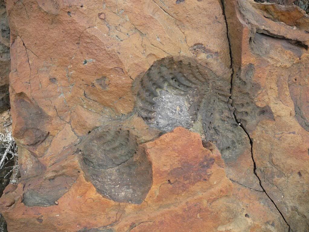
BTW, you might be interested in these fossils found mid-peninsula at around 400 feet elev. The rocks have been "cooked" it seems, after the fossils
were formed....there is a nearby pluton at Punta Cono so perhaps that's the stove...??? Another geologist thought they were brachiopods, which could
go back well over 100 mil yrs.
|
|
|
bajabuddha
Banned
Posts: 4024
Registered: 4-12-2013
Location: Baja New Mexico
Member Is Offline
Mood: Always cranky unless medicated
|
|
Very true, Mexitron. San Pedro Martyr is only a sliver of the gigantic California Batholith, which includes the Sierra Nevadas, Cataviña w/ El
Pedregoso, etc. Granite IS basalt that never touched air, as basalt is granite that did make it to the atmosphere. It formed way back when (tens of
millions of years ago, acutally more) but only emerged to be eroded recently. It was the recent collision of the Pacific plate with the Continental
plate that started the tilting and uplifiting of the Baja ranges, hence the gradual western slopes and the sharp precipitous cliffs of the eastern
sides. Lots to be learned from the large scapes.
Your fossils are wonderful too... just the fluctuation of sea levels due to ice age(S) of just the last few million years leaves all kinds of young
fossils not too far inland from the coastlines; one good dig is just west of San Ignacio, at the base of the road up to the nearest Microonda tower.
There's a large white quarry to the northwest of the highway, lots of stuff there. It's a bed of 'turtilleras (small spiral mollusk shells) dating
11myo, covered by a 'tuff' layer (volcanic ash). That would be about the time Baja was starting its' separation, looooong before the current
volcanoes around the area now... but still, a hotbox. The Mexican coastline then was covered with a shallow sea, rich in life, but a big blowout
caused a mass-destruction like St. Helens, and all were covered and entombed. Page 87 of Minch's book.
Another great hunting ground are the bluffs west and coastal from El Rosario. More, south of San Bruno are bluffs with megalodon teeth. I have a
necklace made from one, it's as long as my thumb.
Your 'cooked' pics are great. The coloring is not from heat, but when buried in what looks like red sands (which would be shallow iron-rich, meaning
fresh water-mixing) the original materials dissolved away and were replaced with minerals, hence the different colors. I've dug many an ancient
fossil in western Utah deserts, some dating back almost 400k, and the older they were the blacker they were too. I wore a 400myo cucaracha
(trilobite) hanging from my ear for over 20 years until finally it got lost. Also, climbers on the top of the Himalayas are marvelled at all the sea
fossils embedded at over 25,000 feet up. They used to be shallow sea bed sediments now thrusted over 4 miles into the air, and the Himalayas aren't
any older than Baja... India struck Asia and pushed up the Hindu Kush ranges in a geologic heartbeat, less than 10my. Mind-boggling.
I just luv this chit, can't get enough of it. Glad it made me pull out the book and read more again, will be driving through it shortly. So much
more to learn, so little time. Just an hour ago i watched a special on a graveyard found in the central Sahara desert dating back almost 10,000
years, finally abandoned less than 5,000y. Two totally different cultures and physical types of peoples buried there with a thousand year hiatus
between each culture. Also, remnants of an ancient lake (like Chapala??? Same time period!!!) filled with 6-foot fish, turtles and hippos, etc.
They said the earth has an eliptical orbit around the sun, not just year by year, and 10k ago the area was less bombarded by UV rays from the sun and
more temperate, like the current savannahs of central Africa today. Baja same latitude? Possible. Same cause and effect? You tell me. Eventually,
all dried up and the dunes blew in. Wwwweeeeeeeee !! The rollercoaster goes on.
I don't have a BUCKET LIST, but I do have a F***- IT LIST a mile long!
86 - 45*
|
|
|
bajabuddha
Banned
Posts: 4024
Registered: 4-12-2013
Location: Baja New Mexico
Member Is Offline
Mood: Always cranky unless medicated
|
|
Mexitron,
Just looked it up in the back of his book, you're right on with the formation of the batholith and plutonic bubbles, Mesozoic era which puts it mas o
meno 100-200myo, and as i mentioned, it's huge 'bubbles' of magma rising upwards through crust but never breaking it... then cooling, forming granite,
and waiting to finally push up and briefly see the sun... granite is soft and erodes fairly quickly. That's why all the boulders of Cataviña are so
rounded; the original matrix got lots of cracks from all the ground movement, and broke into 'blocks' that are now 'balls' due to rain/wind. El
Pedregoso is a classic example. Cool looking volcanic plugs around it that as you said are only a few myo, creating the basalt crusting around it.
Sheesh. I need another toddy.
I don't have a BUCKET LIST, but I do have a F***- IT LIST a mile long!
86 - 45*
|
|
|
bajabuddha
Banned
Posts: 4024
Registered: 4-12-2013
Location: Baja New Mexico
Member Is Offline
Mood: Always cranky unless medicated
|
|
OMA!!!!! (oh my allah) That just made me a Junior Nomad !!!
I'LL MAKE A BIGGER TODDY !!!!   
I don't have a BUCKET LIST, but I do have a F***- IT LIST a mile long!
86 - 45*
|
|
|
DavidE
Ultra Nomad
Posts: 3814
Registered: 12-1-2003
Location: Baja California México
Member Is Offline
Mood: 'At home we demand facts and get them. In Mexico one subsists on rumor and never demands anything.' Charles Flandrau,
|
|
" It's a wonderful world. Hard to believe some think it's only 4800 years old and we drowned all the dinosaurs. "
Whaaaaaaat? Dont'cha know dinosaurs and such nonsense are TRICKS of da debil to sort out the troo bleevers from the folks destined to take the final
elevator that has only one button (Going Down?)
BTW bet-cha nickel Las Tres Virgenes get snow on them this winter.
A Lot To See And A Lot To Do
|
|
|
elbeau
Nomad
Posts: 256
Registered: 3-2-2011
Location: Austin, TX
Member Is Offline
|
|
What about the aquifer feeding the Rio San Ignacio? There's certainly not enough precipitation to feed the springs there. Is the water feeding the
springs from millions of years ago too?
|
|
|
Barry A.
Select Nomad
Posts: 10007
Registered: 11-30-2003
Location: Redding, Northern CA
Member Is Offline
Mood: optimistic
|
|
This "aquafir" business and "Fossel Water"-------------I have always wondered what it actually takes to re-charge the aquafirs under desert regions,
if it's happening at all. I realize that the occasional deluge mosty runs off into the sea in many places----ok, I get that. But what about tiny
fossel aquafirs like in the Borrego Springs area of Anza-Borrego which have no outlets to the sea normally--------folks have been pumping that aquafir
for 75 plus years, and yes it has gone down significantly, but surely there must be some recharge going on from the occasional deluge, winter rains,
or from the constant flow of the two tiny streams that flow into it or it would have been exhausted by man years ago?!?!?!?!. I wonder if there are
any successful and conclusive studies on this subject, and what are the results? When I hear or read "----never to be replenished-----" about Fossel
water aquafirs I wonder????
Barry
|
|
|
David K
Honored Nomad
Posts: 65551
Registered: 8-30-2002
Location: San Diego County
Member Is Offline
Mood: Have Baja Fever
|
|
Water pouring out near the top of a mountain (as opposed to the base of one) has fascinated me... Case in point, the streams that pour out of the
rocks just above (west of) Mission Santa Maria. I mean, where does it come from (near the top of the range... and a desert too)? I understand granite
is porous and stores water from the infrequent rains... but, it is still amazing to me.
Another place is the white slope spring just past the Arroyo el Volcán crossing on the road to La Olvidada from El Mármol. It is near the top of a
small hill... nothing (gravity-wise) feeds it. So, I think it must be a fault line or underground pressure forces it up there?
|
|
|
| Pages:
1
2
3
4 |


