| Pages:
1
2
3
4 |
JDCanuck
Super Nomad
   
Posts: 2421
Registered: 2-22-2020
Member Is Offline
|
|
Quote: Originally posted by BeemerDan  | Thats a good looking Flyin Brick, Great bike.
I don't know if I'd take that to Baja on anything less than pavement, and well packed dirt, and I sure wouldn't air down much with those rims in rocky
areas.
I don't use GPS, never had one.
For Baja I use the National Geo Baja Norte/South maps, They're waterproof and tear resistent, At home I use my Baja atlas to plan with, and transfer
routes I like to the maps.
I know the used bike market is crazy right now with inventories so low, but I really think you'd be better off exploring with a more 50/50 oriented
bike like an old KLR650/DR650 etc
Are you planning on trucking the bike down and returning that way, or leaving it there?
|
Hi Dan: Thanks for the pointer on the maps. I will definitely take a look for them. No, I agree with you both my collector BMW's are not suited to
what Id be riding through down in Baja, the R80RT has the huge fairing and the K75 also produces way too much under seat heat from the water cooling
in temps above 40C. If I take any bikes down it will be the KZ440LTD heavily modified and perhaps even the BWS50 for my wife to putter around on. I am
thinking I might take a look at the Italikas for shorter trips in and out of La Paz. Whatever looks to be cheapest.
|
|
|
JDCanuck
Super Nomad
   
Posts: 2421
Registered: 2-22-2020
Member Is Offline
|
|
Thanks again JZ: I think you managed to share 3 very applicable rides for a mixed group of tastes. Seven Sisters looks really great for those that
want to offroad in the sandy ocean side. The rest of the crew could sit back in Santa Rosalillita and enjoy the local refreshments for a day or two.
[Edited on 8-8-2021 by JDCanuck]
[Edited on 8-8-2021 by JDCanuck]
|
|
|
JDCanuck
Super Nomad
   
Posts: 2421
Registered: 2-22-2020
Member Is Offline
|
|
Dan: The flying brick has let me see a lot of BC Canada over the past few years without breaking the bank on costs. Up here we get our insurance at
about 80 percent reduction if it's collectors eligible. This one has given me about 60,000 km problem free riding in 3 years, up the Cassiar to Hyder
and Watson Lake, out to the west coast along the Nass Valley, down and over the "going to the sun" ride in Montana and back out here to the Island.
Very little rocky mountain trails tho.
|
|
|
David K
Honored Nomad
        
Posts: 65443
Registered: 8-30-2002
Location: San Diego County
Member Is Offline
Mood: Have Baja Fever
|
|
My Baja Bound article (with road log and map):
https://www.bajabound.com/bajaadventures/bajatravel/the_dist...
My Seven Sisters 2017 trip report (photos, maps, mileages):
https://www.tacomaworld.com/threads/2017-baja-expedition-4-v...
My mileages on the Baja Almanac maps:
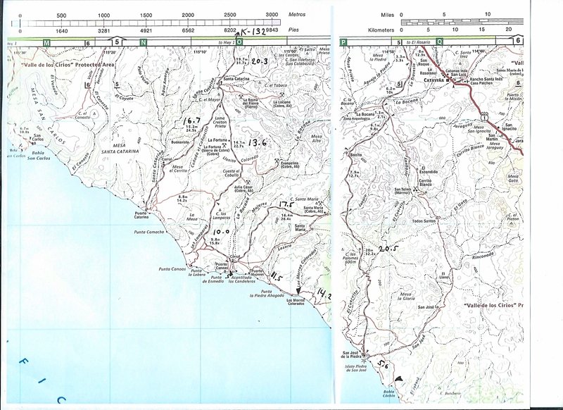 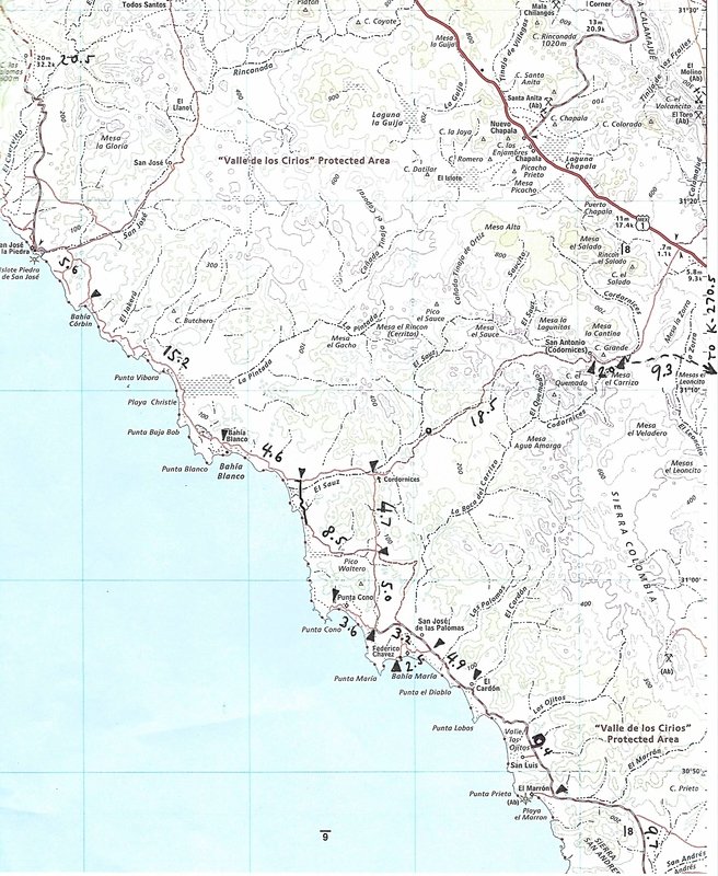
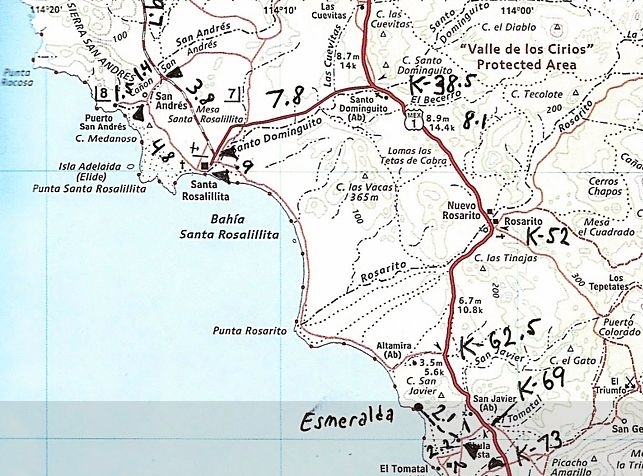
[Edited on 8-8-2021 by David K]
|
|
|
BeemerDan
Nomad
 
Posts: 187
Registered: 1-13-2011
Location: Port Orchard Wa
Member Is Offline
|
|
Quote: Originally posted by JDCanuck  | | Dan: The flying brick has let me see a lot of BC Canada over the past few years without breaking the bank on costs. Up here we get our insurance at
about 80 percent reduction if it's collectors eligible. This one has given me about 60,000 km problem free riding in 3 years, up the Cassiar to Hyder
and Watson Lake, out to the west coast along the Nass Valley, down and over the "going to the sun" ride in Montana and back out here to the Island.
Very little rocky mountain trails tho. |
Riding BC and the Yukon are my favorite summer rides, So much to see and do and the history is amazing, Cassiar is my preferred rte both up and back.
I haven't done Nass valley but its another on my bucket list along with the Bella Coola run.
On my last ride up I almost was taken out by a cow Moose between Kitwanga and Meziden junction, It came straight out of the bush from the side of the
road. Stayed many a time at Sealaska inn and have done the ride up to Salmon glacier. At Watson lake I always stayed at the Air Force lodge, unique
place. When heading to Dawson city I use the Robert Campbell weather permiting to avoid Whitehorse, and usually stop at Ross river or Carmacks for the
night.
So much to see and do up there!
|
|
|
motoged
Elite Nomad
     
Posts: 6481
Registered: 7-31-2006
Location: Kamloops, BC
Member Is Offline
Mood: Gettin' Better
|
|
BC (Canada) has a lot to offer riders who want to stay on paved roads, even more for those interested in enjoying forest service roads that tend to be
good two-laned maintained gravel roads manageable by experienced riders on big bikes, and even more for "dual-sport" riders as well as dirt et al
riders.
Baja touring on big bikes (a term generally accepted to denote bikes larger than 500 - 650 cc ) is limited to paved roads. On some of my rides with
folks in Baja some riders freaked out when leaving paved hiway to access a roadside tienda or a rest stop due to the presence of sand and their
inexperience with such conditions.
So.... I think developing an ability to understand the dynamics of sand, loose road surfaces, and a heavy bike present an essential learning curve. I
have ridden a BMW 1100GS, 800GS, KTM 690, and KTM 450 in Baja....and if I had one bike to do it all it would be the 450, then the 690 as long as I
wasn't desert cross-countrying.... and the 1100 if I wanted to miss my favourite parts of Baja (rode the 1100 from Mulege to San Juanico and back once
and wouldn't do that again....but at least I have cheap-seat bragging rights to that one).
The topic seems to be: "What should I ride; where should I ride, and what should I see ?"
We all have different ways of enjoying Baja on a bike. Not everyone enjoys the risky challenge of deep sand, whoops, and cactus. Some just want to do
a Starbucks run so we can bench-ride with a latte. And others like a mix of riding conditions we feel comfortable with getting to a recommended or
secret location with a view and maybe a place to have a taco and libation.
No one way to ride Baja.
DK and JZ's maps are very handy, the vids encouraging and visually informative, and GPS tracks for those into that are useful to some extent.
For some, the ride is about a destination, for others the ride is about the ride.
There are a few exploratory rides I have done where I have intentionally not proceeded to the ultimate destination, just stopping short enough to keep
the destination as a surprise for the next time doing that track... kind of like a "ridus interruptus"
approach to exploration.
Baja advice on places to go will be geographical in nature but will include good places to eat, have a view, and good roads.....all of which will
change with time.
El Triunfo has/had ? a bakery/restaurant, for instance, that is a gem....killer fire-brick oven baking and pizza place. Several years ago I was in
Todos Santos for several weeks of south cape riding on my 690 and would do that ride partially off-road a few times a week just for a good coffee and
a few of the best cinnamon buns I have ever had... and winding my way though easy pavement and marginal double tracks. Some of those rides were as
much fun as any other....plus there was a bun reward.
Lots of ways to enjoy Baja riding...
But there are risks.... 

https://advrider.com/f/threads/she-slapped-me-with-little-provocation.666961/
[Edited on 8-8-2021 by motoged]
[Edited on 8-8-2021 by motoged]
[Edited on 8-8-2021 by motoged]
[Edited on 8-8-2021 by motoged]
Don't believe everything you think....
|
|
|
JZ
Select Nomad
      
Posts: 13986
Registered: 10-3-2003
Member Is Offline
|
|
You definitely want to ride into Bahia de los Angeles. It's about 38 miles from Hwy 1 to the town. Probably the smoothest road in all of Baja. A
very nice drive and you'll be hard pressed to find a denser forest of cactus anywhere in the world.
There are like 16 islands in the bay and lots of pangas to take you out to see them. It is an easy 7 mile ride from town to La Gringa. Lots of spots
there to stop and enjoy the ocean.
Several day trips in the area for ppl with smaller bikes that want to get them offroad. One is heading back out of town, then going North up through
the dry lake bed, Agua Amaga, and connecting with a jeep trail that takes you to a big bay - Ensenada Alcatraz.
The lake bed can be ridden with any bike and is right off the highway. You can have some drag races out there. Maybe have a local with a pickup help
you scrounge up an old dead tree/bushes and build a big ass bonfire for a small bike rally. The rest of the way to ocean has a lot of sand and
whoops, fun ride if you have a bike that is capable.
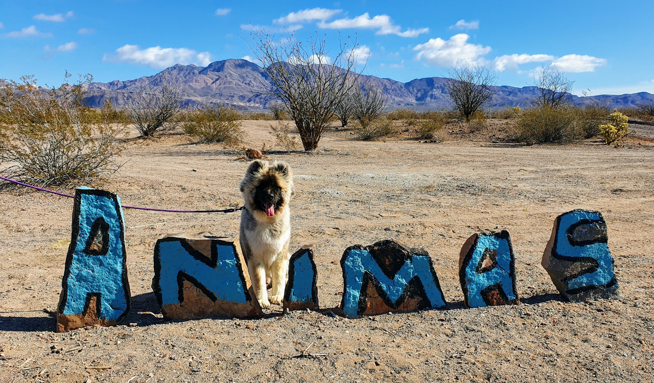
Another day trip is heading South out of town and going about 35 miles to Bahia Las Animas. The main road is a little bumpy from small rocks, and the
last section off the main road into the bay is sandy. So not for the non-adventure bikes.

[Edited on 8-8-2021 by JZ]
|
|
|
David K
Honored Nomad
        
Posts: 65443
Registered: 8-30-2002
Location: San Diego County
Member Is Offline
Mood: Have Baja Fever
|
|
It is Agua Amarga

The red line is the L.A. Bay highway (just west of the San Borja road).
My maps have the road (Km. 38) across the dry lake and on to the two coast locations (Bahía Guadalupe/ Ensenada Alcatraz and Punta Candelero):
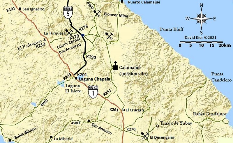
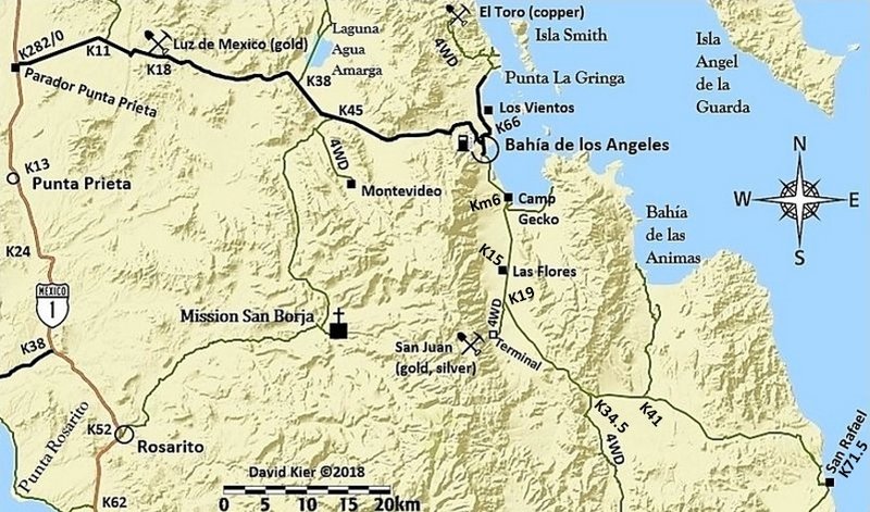
[Edited on 8-9-2021 by David K]
|
|
|
JZ
Select Nomad
      
Posts: 13986
Registered: 10-3-2003
Member Is Offline
|
|
Thx. Updated my library.
[Edited on 8-9-2021 by JZ]
|
|
|
David K
Honored Nomad
        
Posts: 65443
Registered: 8-30-2002
Location: San Diego County
Member Is Offline
Mood: Have Baja Fever
|
|
You are welcome!
|
|
|
JZ
Select Nomad
      
Posts: 13986
Registered: 10-3-2003
Member Is Offline
|
|
As DK's map shows, another day trip ride could be to the San Borja Mission. I've never been out to see it, so can't comment on difficulty on a bike.
|
|
|
JZ
Select Nomad
      
Posts: 13986
Registered: 10-3-2003
Member Is Offline
|
|
Probably just typed it in wrong. I don't use any external maps. Just what ppl post here, what's on Google Earth, or Navonics (boating app). I guess
the last two are map sources.
|
|
|
David K
Honored Nomad
        
Posts: 65443
Registered: 8-30-2002
Location: San Diego County
Member Is Offline
Mood: Have Baja Fever
|
|
Quote: Originally posted by JZ  | As DK's map shows, another day trip ride could be to the San Borja Mission. I've never been out to see it, so can't comment on difficulty on a bike.
|
Except for a couple of rocky surface miles, it is a fast, graded road (or was)!
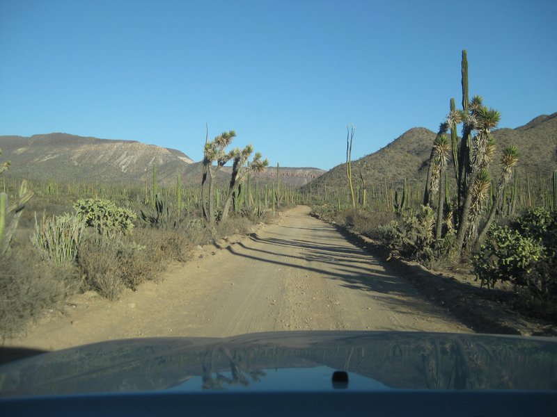
|
|
|
JZ
Select Nomad
      
Posts: 13986
Registered: 10-3-2003
Member Is Offline
|
|
Pic of La Ventana, which is in the bay. It's much bigger than it looks. You can pull right up to it and get off and walk inside it.

|
|
|
JDCanuck
Super Nomad
   
Posts: 2421
Registered: 2-22-2020
Member Is Offline
|
|
Quote: Originally posted by David K  | Quote: Originally posted by JZ  | As DK's map shows, another day trip ride could be to the San Borja Mission. I've never been out to see it, so can't comment on difficulty on a bike.
|
Except for a couple of rocky surface miles, it is a fast, graded road (or was)!
Roads like that seem pretty doable to bigger bikes to me, as long as there is no more than 2 or 3 inches of soft sand over hard surface. It's the
tight downhill switchbacks with 3 inch boulders that get me worried. Most of DK's shots look reasonable for all but the Harley's and Gold Wings maybe.
|
|
|
|
JZ
Select Nomad
      
Posts: 13986
Registered: 10-3-2003
Member Is Offline
|
|
Quote: Originally posted by JDCanuck  |
Roads like that seem pretty doable to bigger bikes to me, as long as there is no more than 2 or 3 inches of soft sand over hard surface. It's the
tight downhill switchbacks with 3 inch boulders that get me worried. Most of DK's shots look reasonable for all but the Harley's and Gold Wings maybe.
|
All the routes I have posted are easy like that except for the ride to Bahia Alcatraz after the lake bed (a lot of sand) and the last leg of Las
Animas (some sand). Animas isn't that bad though.
[Edited on 8-9-2021 by JZ]
|
|
|
willardguy
Elite Nomad
     
Posts: 6451
Registered: 9-19-2009
Member Is Offline
|
|
as the great Stephane Peterhansel would say run what you brung, I'll date myself, I offroaded the crap out of the big FJ12!
|
|
|
JZ
Select Nomad
      
Posts: 13986
Registered: 10-3-2003
Member Is Offline
|
|
Here is another really special ride in BCS.
Start out in Los Barriles and ride up the coast about 25 miles. Los Barriles is very cool town. There is a nice bar with great craft beers on tap
right on the main drag.
The 25 miles section to the North is a top 3 coastal ride in Baja. It's dirt, but super easy dirt.
Many spots to pull over and get out on some of the prettiest beaches you will see in Baja.


|
|
|
AKgringo
Elite Nomad
     
Posts: 6310
Registered: 9-20-2014
Location: Anchorage, AK (no mas!)
Member Is Online
Mood: Retireded
|
|
JZ, that is one of my favorite drives, and I was on it last November. The northern end crossing over the mountains was in pretty rough shape in a few
spots.
I did not need four wheel drive, but I would not want to be on a heavy bike on that road. I encountered no traffic between the turn off near Los
Planes and the beaches north of El Cardonal.
If you are not living on the edge, you are taking up too much space!
"Could do better if he tried!" Report card comments from most of my grade school teachers. Sadly, still true!
|
|
|
JZ
Select Nomad
      
Posts: 13986
Registered: 10-3-2003
Member Is Offline
|
|
Yeah, they should stop when the trail starts cutting inland off the coast. The canyon run is very rocky.
[Edited on 8-9-2021 by JZ]
|
|
|
| Pages:
1
2
3
4 |

