| Pages:
1
2
3
4 |
JDCanuck
Super Nomad
   
Posts: 2421
Registered: 2-22-2020
Member Is Offline
|
|
Touring Baja by Motorbike
Started this thread with the idea of getting more accessible interesting day trips or multi day trips for larger touring bikes. Minimal off pavement
access would be great. Pics if you have them please.
|
|
|
JDCanuck
Super Nomad
   
Posts: 2421
Registered: 2-22-2020
Member Is Offline
|
|
If anyone has done the loop from La Paz through El Triunfo to Cabo, and back via Todos Santos with lots of pics I think a lot of people would find
that one interesting. Comments on hazards and biker friendly spots to stay along the way too maybe? We have Riders Retreats very common up here where
bikers can ride in with minimal gear and rent tents set up and stocked for over nites, anything similar down there?
[Edited on 8-7-2021 by JDCanuck]
|
|
|
motoged
Elite Nomad
     
Posts: 6481
Registered: 7-31-2006
Location: Kamloops, BC
Member Is Offline
Mood: Gettin' Better
|
|
KISS
This will be an interesting thread....until it goes off topic ... 
My contribution is simple:
Get a map and look at it,
A GPS might be helpful but not at all necessary.
Use your imagination and sense of adventure...and explore.
Ride YOUR ride....not a copycat trip someone else did.
On/off-road riding is your choice of range and equipment.
It's that simple.
Don't believe everything you think....
|
|
|
David K
Honored Nomad
        
Posts: 65443
Registered: 8-30-2002
Location: San Diego County
Member Is Offline
Mood: Have Baja Fever
|
|
Quote: Originally posted by JDCanuck  | If anyone has done the loop from La Paz through El Triunfo to Cabo, and back via Todos Santos with lots of pics I think a lot of people would find
that one interesting. Comments on hazards and biker friendly spots to stay along the way too maybe? We have Riders Retreats very common up here where
bikers can ride in with minimal gear and rent tents set up and stocked for over nites, anything similar down there?
[Edited on 8-7-2021 by JDCanuck] |
We did the loop, as well as day trips from La Paz in 2012 and I did it again in 2017. Took many photos, posted on the Trip reports section both times.
El Triunfo is maybe the most-interesting of the many sites?
|
|
|
JDCanuck
Super Nomad
   
Posts: 2421
Registered: 2-22-2020
Member Is Offline
|
|
Thanks David: Located that section and a whole lot of trip reports from you. Will definitely look through them.
|
|
|
David K
Honored Nomad
        
Posts: 65443
Registered: 8-30-2002
Location: San Diego County
Member Is Offline
Mood: Have Baja Fever
|
|
Great... Here are the Nomad links for others:
2017: http://forums.bajanomad.com/viewthread.php?tid=87323
2012: http://forums.bajanomad.com/viewthread.php?tid=61576 (see Days 6 and 8)
Free of the Photobucket watermark, I made a web page of the 2012 trip: http://vivabaja.com/712/
The 2017 trip report, but posted on Tacoma World where the photos are in their original form (sized and no watermark): https://www.tacomaworld.com/threads/2017-baja-expedition-6-s...
[Edited on 8-7-2021 by David K]
|
|
|
JZ
Select Nomad
      
Posts: 13987
Registered: 10-3-2003
Member Is Offline
|
|
Agua Verde is a great day trip from Loreto. Hard packed, well graded dirt road. An incredible canyon ride. Beautiful bay with a little
restaurant/store.

[Edited on 8-8-2021 by JZ]
|
|
|
mtgoat666
Platinum Nomad
       
Posts: 20591
Registered: 9-16-2006
Location: San Diego
Member Is Offline
Mood: Hot n spicy
|
|
Quote: Originally posted by motoged  | This will be an interesting thread....until it goes off topic ... 
My contribution is simple:
Get a map and look at it,
A GPS might be helpful but not at all necessary.
Use your imagination and sense of adventure...and explore.
Ride YOUR ride....not a copycat trip someone else did.
|
Most people today dont know how to navigate with paper map. They need gadget to tell them where they are, where to go. Most people want to follow a
recommended trip/route, are uncomfortable with winging it or exploring.
Woke!
Hands off!
“Por el bien de todos, primero los pobres.”
“...ask not what your country can do for you – ask what you can do for your country.” “My fellow citizens of the world: ask not what America
will do for you, but what together we can do for the freedom of man.”
Pronoun: the royal we
|
|
|
JDCanuck
Super Nomad
   
Posts: 2421
Registered: 2-22-2020
Member Is Offline
|
|
Quote: Originally posted by mtgoat666  | Quote: Originally posted by motoged  | This will be an interesting thread....until it goes off topic ... 
My contribution is simple:
Get a map and look at it,
A GPS might be helpful but not at all necessary.
Use your imagination and sense of adventure...and explore.
Ride YOUR ride....not a copycat trip someone else did.
|
Most people today dont know how to navigate with paper map. They need gadget to tell them where they are, where to go. Most people want to follow a
recommended trip/route, are uncomfortable with winging it or exploring.
|
I had a hard time finding any paper maps when I was down there last. Finally found one that covered the entire peninsula and it's now pinned to my
wall. Thanks JZ for that last one from Loreto. I have been told it is also a very beautiful city ranking with La Paz for #'s 1 and 2. I've only seen
La Paz til now, so will certainly try to spend some time near there. Got my first suggested trip map saved in new folder, please keep more like that
coming. Looks very suitable for the larger touring bikes the thread is meant for.
[Edited on 8-8-2021 by JDCanuck]
|
|
|
JDCanuck
Super Nomad
   
Posts: 2421
Registered: 2-22-2020
Member Is Offline
|
|
Any places similar to this local one down there? Inexpensive, ride in and get set up quick with a bit of gathering around the fire to swap
experiences?
http://ridersretreat.ca/
|
|
|
motoged
Elite Nomad
     
Posts: 6481
Registered: 7-31-2006
Location: Kamloops, BC
Member Is Offline
Mood: Gettin' Better
|
|
If you have internet access you have Google Earth for a map....map plus satellite ...
It gives you a sense of terrain and has any road you would want for a big bike.
Don't believe everything you think....
|
|
|
JDCanuck
Super Nomad
   
Posts: 2421
Registered: 2-22-2020
Member Is Offline
|
|
Quote: Originally posted by motoged  |
If you have internet access you have Google Earth for a map....map plus satellite ...
It gives you a sense of terrain and has any road you would want for a big bike. |
I don't mind taking advice from those who know the areas far better than me. This seemed like the quickest way to put together a few suggestions for
riders who like me want to see the area on short trips and aren't into the off road thrills. We'll see how it pans out. Have shared with a few like
minded friends from up here planning to go down there in the future.
|
|
|
JZ
Select Nomad
      
Posts: 13987
Registered: 10-3-2003
Member Is Offline
|
|
What bike(s) are you referring to specifically?
|
|
|
JZ
Select Nomad
      
Posts: 13987
Registered: 10-3-2003
Member Is Offline
|
|
Google Maps has all the paved roads mapped. That should be your go to for the pavement.
They let you download map areas for use when you don't have cell service.
https://support.google.com/maps/answer/6291838?hl=en&co=...
|
|
|
JZ
Select Nomad
      
Posts: 13987
Registered: 10-3-2003
Member Is Offline
|
|
You don't want to use Google Earth when out riding in Baja. It's great for trip prep, but so much of Baja doesn't have cell service that it makes
Google Earth worthless.
That being said the phone based offroad GPS apps have pretty much everything that Google Earth has.
Gaia and Back Country Navigator (my favorite) are the best. You can use topo maps or satellite imagery as your overlay. You can download areas to
your phone and have access even when you don't have service. I spent the time and downloaded all of Baja with high res satellite imagery. It's like
Google Earth, but you can see yourself driving on the map.
|
|
|
JDCanuck
Super Nomad
   
Posts: 2421
Registered: 2-22-2020
Member Is Offline
|
|
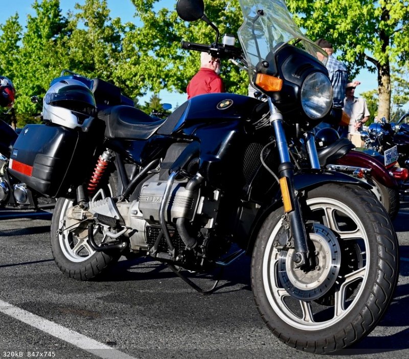
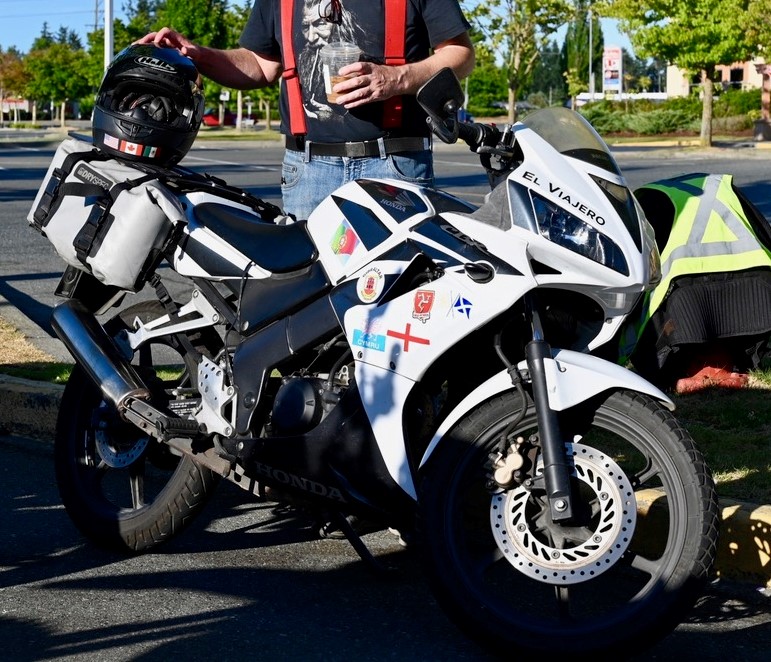
Group i hang out with has everything from CBR125 (presently doing the most international touring) up to the larger BMW Adventure bikes, Harleys and
everything in between. Pretty much all of them are more capable riders than myself and I prefer my BMW K75. Pretty wide grouping to plan for. Some
would stick to pavement, and some would prefer off roading. Saw lots of threads here dealing with off road trips, but couldn't find any for touring in
general.
[Edited on 8-8-2021 by JDCanuck]
 
|
|
|
JZ
Select Nomad
      
Posts: 13987
Registered: 10-3-2003
Member Is Offline
|
|
Quote: Originally posted by JDCanuck  |
Group i hang out with has everything from CBR125 (presently doing the most international touring) up to the larger BMW Adventure bikes, Harleys and
everything in between. Pretty much all of them are more capable riders than myself and I prefer my BMW K75. Pretty wide grouping to plan for. Some
would stick to pavement, and some would prefer off roading. Saw lots of threads here dealing with off road trips, but couldn't find any for touring in
general. |
Gotcha. I don't ride on the road, so won't be too much help there. I will say, regarding the Loreto to Agua Verde ride, the highway part to the turn
off takes you through arguably the most beautiful section of mountains in Baja.
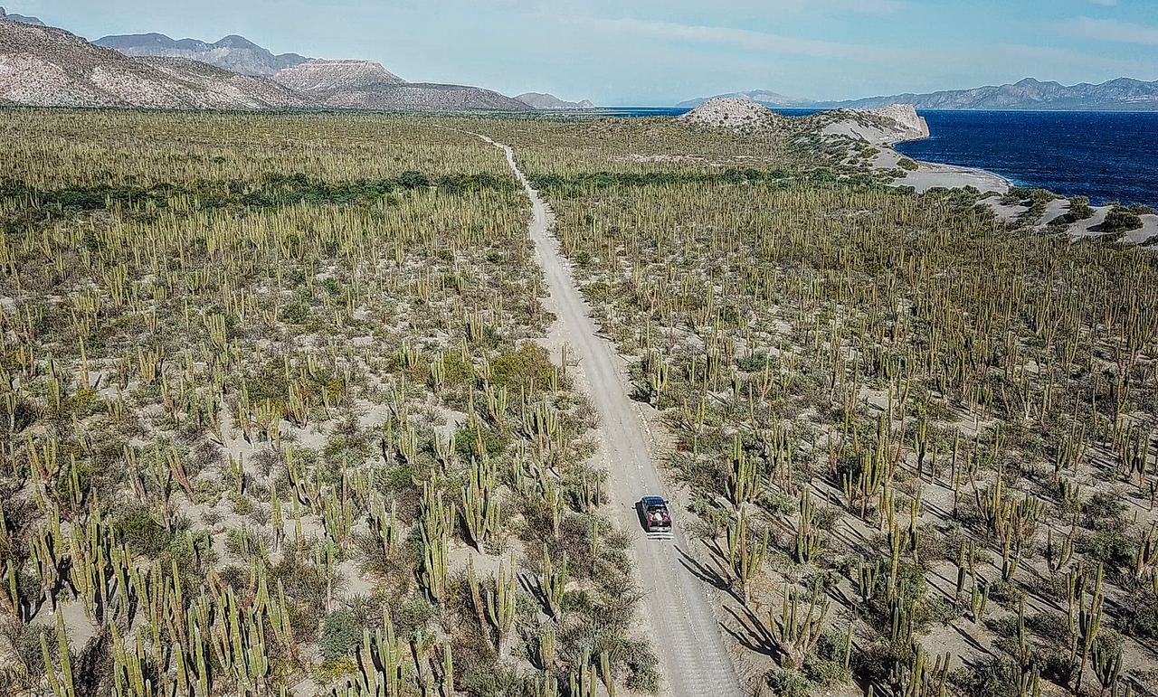
Here is another very easy dirt road trip. You could probably even take a Harley, but maybe not the best idea.
La Paz to San Evarsito. I've done it as a day trip from La Paz a few times. It's about 2-3 hours one way (70 miles). San Evarsito is a large sized
fishing village with several houses. I think they have some primitive rooms to rent there. There is a restaurant. You can also camp on the beach.
The ride itself is A+, but bay is just "okay." That said, for $100 you can get on a panga and they will take you out to some breath-taking spots at
the nearby islands.

Last section before you reach the bay.

[Edited on 8-9-2021 by JZ]
|
|
|
JDCanuck
Super Nomad
   
Posts: 2421
Registered: 2-22-2020
Member Is Offline
|
|
Thanks JZ. Both those suggestions look great!
|
|
|
BeemerDan
Nomad
 
Posts: 187
Registered: 1-13-2011
Location: Port Orchard Wa
Member Is Offline
|
|
Thats a good looking Flyin Brick, Great bike.
I don't know if I'd take that to Baja on anything less than pavement, and well packed dirt, and I sure wouldn't air down much with those rims in rocky
areas.
I don't use GPS, never had one.
For Baja I use the National Geo Baja Norte/South maps, They're waterproof and tear resistent, At home I use my Baja atlas to plan with, and transfer
routes I like to the maps.
I know the used bike market is crazy right now with inventories so low, but I really think you'd be better off exploring with a more 50/50 oriented
bike like an old KLR650/DR650 etc
Are you planning on trucking the bike down and returning that way, or leaving it there?
|
|
|
JZ
Select Nomad
      
Posts: 13987
Registered: 10-3-2003
Member Is Offline
|
|
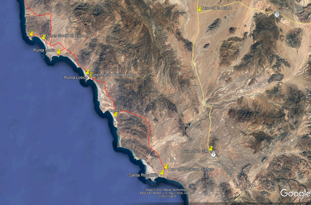
Here is a trip to what I would argue are the most beautiful Pacific coast beaches in Baja.
The lower part of the Seven Sisters. Not far from the turn off to Bahia del Los Angeles. It's paved from MX 1 to Santa Rosalillita. Then very hard
packed and well graded dirt up to Cono. You can drive a truck with a decent suspension 50mph no problem. The last couple miles from the main road to
the beach is a bit more challenging.
North of there it gets harder the further you go.
There is a very small motel in Santa Rosalillita. It's a good sized town overall. No cell service or gas station. But you can definitely get gas
there.

Starting at 4 mins of this video to about 6:45 you will get a glimpse of what the beaches look like.
[Edited on 8-8-2021 by JZ]
|
|
|
| Pages:
1
2
3
4 |

