| Pages:
1
2
3
4 |
Neal Johns
Super Nomad

Posts: 1687
Registered: 10-31-2002
Location: Lytle Creek, CA
Member Is Offline
Mood: In love!
|
|
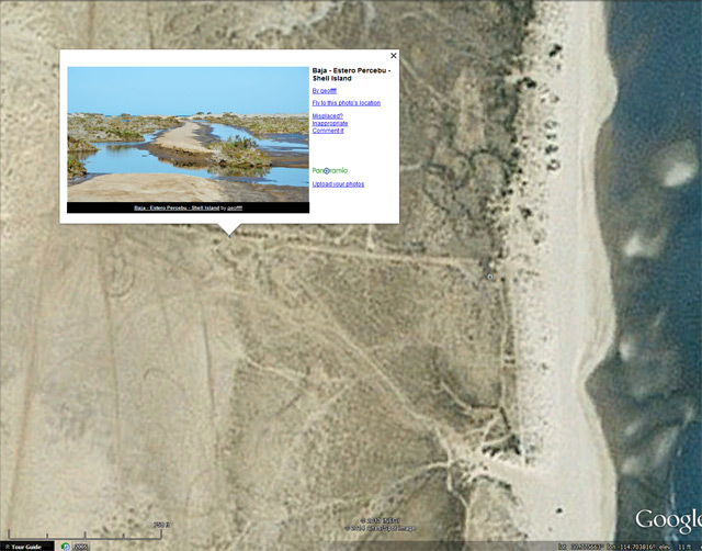
Yes, DK, I remember Shell Island....
Baja's Shell Island Adventure (1980)
I had discovered the remote Baja beach (now named Shell Island by David K) poking around the area the year before in my Land Cruiser. The two-track
off the old road between San Felipe and Puertecitos had looked inviting, so I took it. My religion is simple, if you pass a desert side road without
taking it, God will get you! After a few miles, we (my girlfriend and I) arrived on the edge of a muddy lagoon separating some sand dunes from the
mainland. We had lunch while we tried to decide whether to drive through the mud or not. We could see that the two-track continued but my chicken
blood was running into my brain. Just then a Jeep passed us with a smirk, and drove on through to the dunes. That was it! No darn Jeep can show up a
Land Cruiser! We crossed with no problems even if our Tru-Traks (remember TruTraks? The BFGs of yesteryear) clogged up.
Surprise! There was a pristine beach on the other side of the dunes with no one in sight except way down south. Hundreds of shells littered the beach
and we had lots of time to look at them because for every revolution of the tires, we moved forward about two feet. Airing down the tire pressure
helped but there was still a lot of slippage. After camping the night, we went on to other things.
Move the clock up a year and I am poking around Baja with two buddies, one with a Jeep CJ-5 and the other in another Land Cruiser. Nightfall
approached and I declared "I know a great place to camp!". It took us a while to get there and it was dark with no moon. The lagoon was full and the
two-track disappeared under the water. Said I: " No problem, I have been here before and if you stay on the track, there won't be any problem, just
follow me". That's when things started to go terribly wrong.
I took off in low range with the two guys behind me and things went OK until the unseen underwater "road" bent right, and I didn't. I started to bog
down and screamed the infamous words "Pass me on the right!" just before I got stuck. The Jeep did so and went two more car lengths before he got
stuck. We heard on the CB the other Land Cruiser say he was stopping. There was a loud silence before they started cursing at me. The other Land
Cruiser was stuck also. The Jeep had a winch on the front bumper which was of little use because we were behind him. I had a small portable winch
which we hooked up to his trailer hitch on the Jeep to pull him backwards a ways. As the winch owner, they let me stand in the foot of brackish water
and operate the controls. What could go wrong, it was only 12 volts? My screams told the others that the kickback voltage from the motor windings was
more that 12 volts and that experiment quickly ended. Next, we broke out the Hi-Lift jacks and pushed some large jack boards down into the mud without
moving the Land Cruiser upward. By that time it was midnight and we decided to sleep in the vehicles until daylight. They didn't sleep too well
because they thought the rising tide would bury them alive. A few crabs in the water and mud did little to calm their fears.
The next days vista was very informative. If we had continued straight the way we were going, we would have been in the unseen mud flat on the edge
of the dunes which was much worse that where we were. Guess we missed that right turn. We fooled around some more with the Hi-Lifts to no avail and
then turned our efforts to the Land Cruiser closest to the mainland. By burying the spare tire in the mud and using a come-along puller, we got him
out about noon. We drove back to San Felipe and tried to hire the large wheeled war-surplus boat launching vehicles to come and pull us out. No luck,
they had to remain there to pull the boats out. We then had to decide which would be better, a 400 foot rope, or some planks to serve as railroad
tracks. Eight foot long, two inch by twelve inch planks were decided upon and we went to the lumberyard on the main drag. They sawed them to length by
hand and we loaded six of them on the Land Cruiser fenders/running boards.
Back at the lagoon in the late afternoon, we set to work getting the Jeep out. For some reason, they vetoed getting my vehicle out first. We pounded
nails into the boards and bent them over to give more traction to the soon to be muddy "railroad tracks" and started to work. Using the boards as
giant jack boards for the Hi-Lift, we managed to get the wheels started up on four "tracks" and laid two more boards behind them. The plan was to go
like heck backwards until the Jeep ran out of track and then pray. We must not have prayed to the right Gods because as soon as the Jeep got off the
boards it would go only about 50 feet, and had no steering control whatever. Oh well, only 350 feet to go. The boards that we could manhandle and lift
so easily early on, took on a life of their own toward the second midnight. The suction from the mud on a heavy eight foot by 12 inch board was all we
could overcome toward the end. We got the Jeep out at midnight and my former friends camped on the warm, dry, sand and informed me that "if" they were
around the next morning, "maybe" they would help me out.
The next morning, the water had gone down a little and we started on my Land Cruiser. Around dark, we and our aching backs had it almost out so
we quit and they again camped in tents on the sand while I spent another night in the Land Cruiser. The next day after a little more work, we all
headed for San Felipe. We checked into Ruben's Camp where we proceeded to wash off the six inches of mud onto the gravel driveway. We got a few funny
looks, but it was a rustic campo at that time so we got away with it. When queried as to where we got the mud, we just shook our head and said
"south". A few months later, my former friends presented me with a tee shirt that said "Pass me on the right!"
Rumor has it that there is a causeway there now.
(Fact: The causeway bridge is high in the air and useless.)
My motto:
Never let a Dragon pass by without pulling its tail!
|
|
|
David K
Honored Nomad
Posts: 65575
Registered: 8-30-2002
Location: San Diego County
Member Is Offline
Mood: Have Baja Fever
|
|
Thank you Neal for reposting your Shell Island horror story. It was very similar to mine from around 1980 in my Subaru (13" tires and no room for
error)... If you keep your tires in the deepest water (depressed terrain from vehicle weight) in the road, that was the firmest. Move a few inches off
the compacted mud and you were in something as firm as wet oatmeal with no bottom.
We arrived well after dark to camp on the ISLAND (see I say island and not beach for a very good reason) and I zigged when I should have zagged, in
the water covered road across the lagoon marsh. Long story short, we slept in the Subaru (viva reclining seats), and I found a large plank of wood by
the dunes, jacked my Subaru up onto the plank and drove ahead, but over towards the firm ruts. Had to do that twice... and then we sloshed on the dry
sand, drove the 2 miles to our camp spot... and collected another great Baja Stuck story!
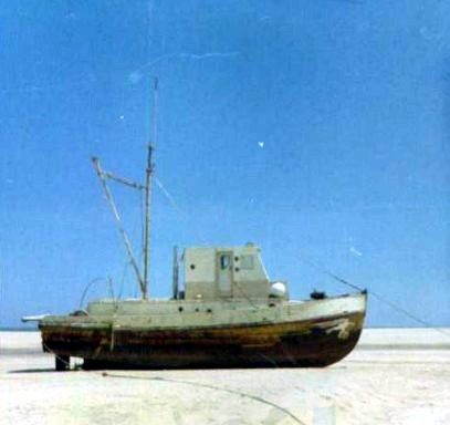
The wood could have come from the Shrimp Boat that was blown behind Shell Island in the 1967 huricane. It was slowly dismantled after sitting locked
up for a few years. Only the engine (Franklin) and tranny were left to rust in the salt flat.
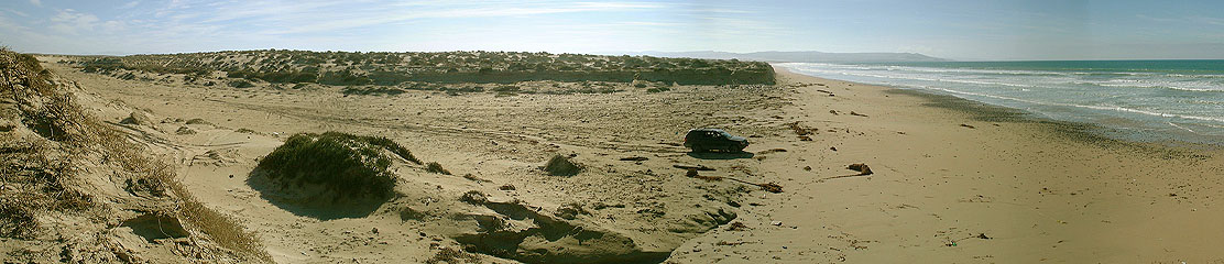
My dad and I on the beach near Laguna Manuela (Variety Beach) just having the greatest surf fishing weekend... But, this is my 1980 Subaru and loaded
the way it was the night we got stuck in the lunar high tide mud of Estero Percebu trying to get onto Shell Island!
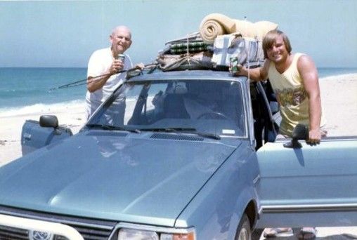
To us, this beach is worth the trouble to get to... and we are usually the only campers out there!
|
|
|
deanfootlong
Junior Nomad
Posts: 53
Registered: 10-7-2013
Member Is Offline
|
|
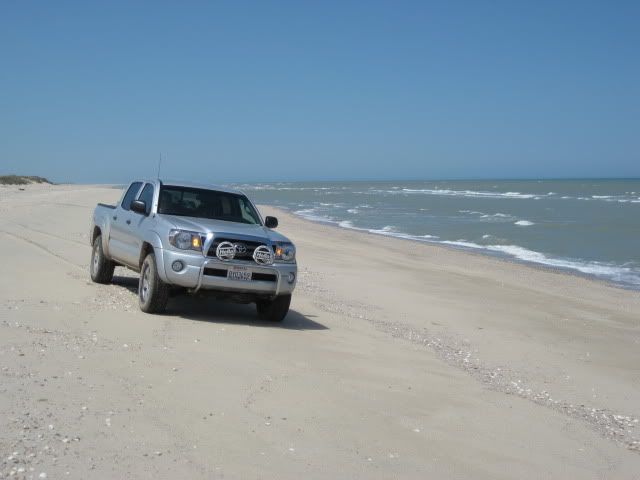
I had a good time surf fishing there too. Caught a couple corbina and several sting ray. Actually I had better luck fishing there than the other
surrounding fishing spots of the area between San Felipe and puertecitos.
|
|
|
David K
Honored Nomad
Posts: 65575
Registered: 8-30-2002
Location: San Diego County
Member Is Offline
Mood: Have Baja Fever
|
|
Corbina (and croaker) are the reason for my folks many returned trips to the area south of San Felipe in the 60's and early 70's... We would camp at
Nuevo Mazatlan (originally known as AGUA DE CHALE), witnessed camp owner Luis Castellanos Moreno plant cuttings of a nearby salt cedar tree to grow
his forest of shade trees, drive the beach 2 miles north to the shallow bay we just called 'The Lagoon'... that later would become the vacation home
site BAHIA SANTA MARIA..., cast into the lagoon/bay entrance on a rising high tide, and have double hookups (using mussel for bait).
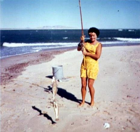
Mom with a pair of corbina at 'the lagoon' (Bahia Santa Maria) about 1967.
|
|
|
geoffff
Senior Nomad
Posts: 721
Registered: 1-15-2009
Member Is Offline
|
|
Safe crossing tide level?
Hey David --
Do you have a feel for what is the maximum tide level for safe crossing, or time to let the mud dry after high tide?
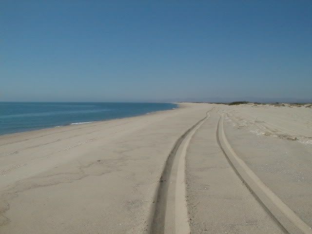
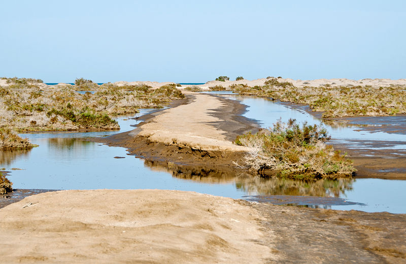
When I last tried in May 2012, I was foiled by the tides (checking a historical Puertecitos tide chart, it looks like it was 10ft tide just after high tide). The road
looked like this, and I didn't dare cross the mud. Yes, that's the ocean in my photo -- I was just feet from the beach.
I'm planning another trip in February, and the predicted tides look similar for my planned ETA.
-- Geoff
[Edited on 1-8-2014 by geoffff]
|
|
|
willardguy
Elite Nomad
Posts: 6451
Registered: 9-19-2009
Member Is Offline
|
|
sometimes ya gotta just go for it geoff!

|
|
|
David K
Honored Nomad
Posts: 65575
Registered: 8-30-2002
Location: San Diego County
Member Is Offline
Mood: Have Baja Fever
|
|
Hi Geoff,
The salt flats flood at an 18 ft. high tide (or above), which is typical around the New or Full moon phase, twice a day... around 2 am and 2 pm +/-. I
use the San Felipe tide chart, as Shell Island is a bit closer to San Felipe than Puertecitos.
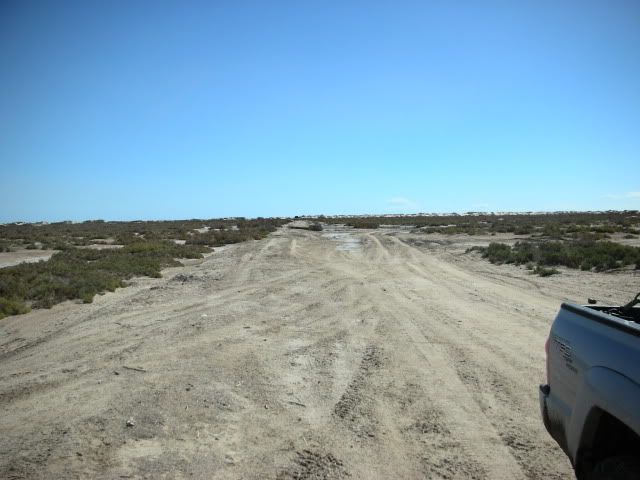
The photo you posted is about halfway across the salt flats (mud flats) or lagoon between the desert and the beach (island).
The mud is very slimy and you may go sideways a bit... but I have not ever got a Tacoma stuck in it (using low range and A-TRAC or a rear locker).
Now, instead of going straight in along the once well elevated causeway to the defunct bridge, I now go in on the lateral original road (goes off to
the right from about where you took picture or just before) and meets the beach 1/4 mile south... next to fisherman's shack.
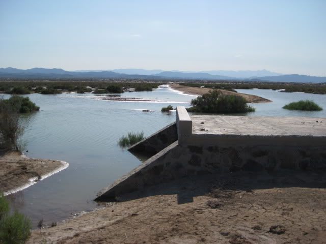
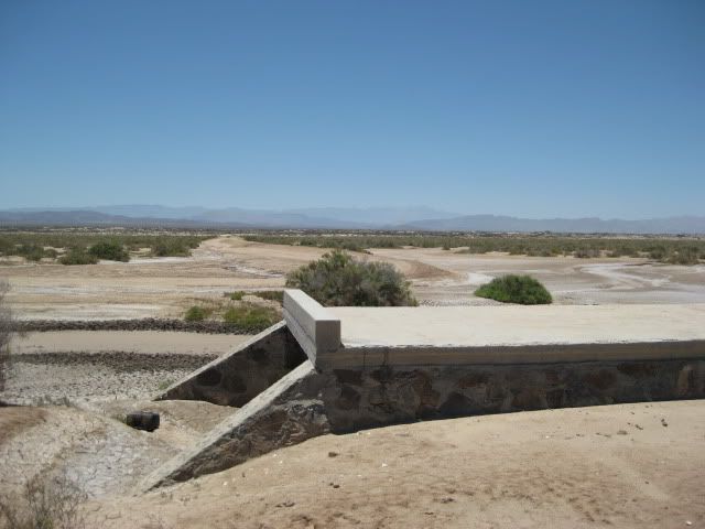
The elevated road and bridge were built about 1984, and I used it as an easy all tide on/off to the island. Whoever built it and thought they could
develop a resort there never did anything more. The elevated causeway began to 'melt' down and by the early 2000's, the bridge could no longer be
used... Here's a photo of Surfer Jim on it in Feb., 2004:

I will be honest and tell you if I come to see that much sea water, I might hesitate too, and have camped at Nuevo Mazatlan instead. But, if already
on the island and it is that flooded when we leave, we have driven through a foot deep sea water to get off the island. Just stay (if you can figure
out where) on the road route.
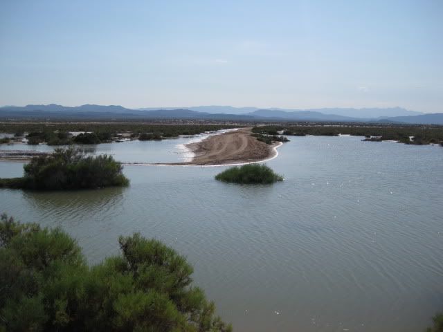
Here it was in July 2011 looking from the bridge towards where you took the above photo, at high tide:
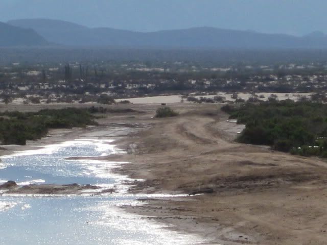
A year earlier (July 2010), dry as a bone!:
Nov. 2008:

Feb. 2007, looking towards the island:
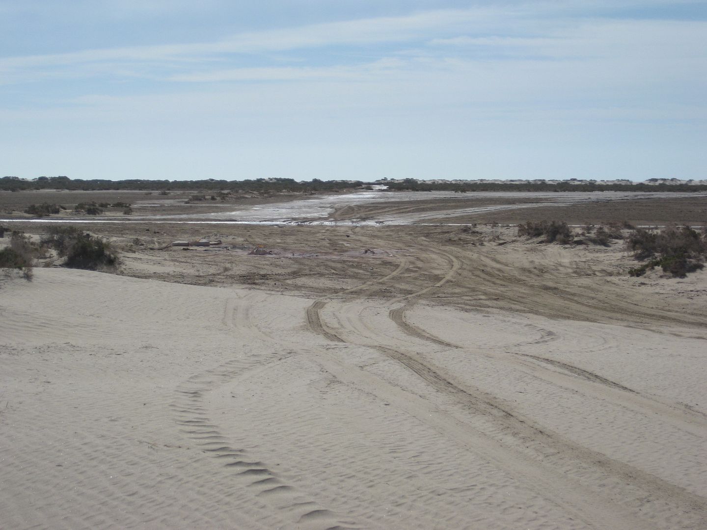
May, 2013, looking towards the island from the edge of the flats (Km. 26 road):
|
|
|
deanfootlong
Junior Nomad
Posts: 53
Registered: 10-7-2013
Member Is Offline
|
|
when I stayed there over thanksgiving 2013, we got there as the sun was going down. the tide was going out but there was still a few inches of water
left and it was all mud. I just went for it. we got sideways and bounced around a bit but made it through. heres a pic after we were leaving. I
stopped to air the tires back up and snapped this photo. ...I still have some of that mud on the jeep.

|
|
|
David K
Honored Nomad
Posts: 65575
Registered: 8-30-2002
Location: San Diego County
Member Is Offline
Mood: Have Baja Fever
|
|
Did you put the Quadra Drive to work? 
It is so nice to see someone actually drive a Jeep Grand Cherokee off road!
|
|
|
deanfootlong
Junior Nomad
Posts: 53
Registered: 10-7-2013
Member Is Offline
|
|
sure did! Im pretty impressed with how quadradrive does in mud and sand. its not like having front and rear lockers, which would be nice, but it does
well. 192k miles and the varilock axles and original transfer case are still working as they should.
|
|
|
David K
Honored Nomad
Posts: 65575
Registered: 8-30-2002
Location: San Diego County
Member Is Offline
Mood: Have Baja Fever
|
|
Great... Like Jeep's Quadra Drive system, Toyota's A-TRAC system can pull you ahead if just one tire is on firm ground... amazing technology that
provides traction like front and rear lockers do, without locking the differentials!
|
|
|
geoffff
Senior Nomad
Posts: 721
Registered: 1-15-2009
Member Is Offline
|
|
| Quote: | Originally posted by David K
It is so nice to see someone actually drive a Jeep Grand Cherokee off road! |
Here's my Jeep Grand Cherokee at Malarrimo Beach back in January 2002. I concur that the Quadradrive works great!
|
|
|
geoffff
Senior Nomad
Posts: 721
Registered: 1-15-2009
Member Is Offline
|
|
| Quote: | Originally posted by David K
Now, instead of going straight in along the once well elevated causeway to the defunct bridge, I now go in on the lateral original road (goes off to
the right from about where you took picture or just before) and meets the beach 1/4 mile south... next to fisherman's shack.
|
Yeah, I guess I was still more than a few feet from the ocean. But it was frustrating to be able to *see* the ocean from there.
I did try driving around to the south a little bit, but the whole area was somewhat muddy, so I got freaked out. I didn't have access to satellite
imagery to be sure I could get across further south. I'll give this a try next time!
The camper van I currently drive is 4x4, so I'm good with traction. Still, I drive alone, so getting stuck is a concern.
-- Geoff
|
|
|
David K
Honored Nomad
Posts: 65575
Registered: 8-30-2002
Location: San Diego County
Member Is Offline
Mood: Have Baja Fever
|
|
You can easily see the original road onto the island in your sat image above. Reaches the beach near the word Google in the lower right corner.
|
|
|
David K
Honored Nomad
Posts: 65575
Registered: 8-30-2002
Location: San Diego County
Member Is Offline
Mood: Have Baja Fever
|
|
Well... It's May, and hoping for a return to Shell Island... The Tacoma really wants to get into the sand again (and so do I)!
|
|
|
El Vergel
Nomad
Posts: 197
Registered: 8-27-2003
Location: San Felipe - Puertecitos Rd., Km. 35 and Santa Mon
Member Is Offline
|
|
Fiesta
David,
The annual El Vergel Volunteer Fire Department Fundraising Event will take place May 25th, this coming Memorial Day weekend. Campo El Vergel is at
Km35 on the San Felipe / Puertecitos Rd., across from Colonia Delicias. Look for the Lighthouse if you're coming from the Playas! Hope to see you and
others there.
Best regards,
Vern
|
|
|
David K
Honored Nomad
Posts: 65575
Registered: 8-30-2002
Location: San Diego County
Member Is Offline
Mood: Have Baja Fever
|
|
Hi Vern, maybe post that in the Baja news forum?
Glad to hear from you and that you still go south!
The Diaz Grave is still lost (I think)!!!
The Lost Mission Santa Isabel Adventure remains an epic example of Baja Nomads getting together for fun and adventure... and was Baja Lou's last
expedition, I do believe...
http://www.bajabound.com/bajaadventures/bajatravel/lost_miss...
FULL NOMAD TRIP REPORT: http://forums.bajanomad.com/viewthread.php?tid=52696
|
|
|
CrisJk12
Newbie
Posts: 15
Registered: 4-25-2014
Location: San Diego
Member Is Offline
|
|
Hey Dave, I was down there a few weeks ago and I was trying to locate that road that leads to shell island, I found one dirt road right off the
highway, I want to say it was after Rancho Percubu ( might be wrong). I drove about a mile and didnt dare to go any further due to a big patch of deep
soft sand (I didnt deflate, since i didnt have anything to air back up with, dont think I would have gotten stuck but didnt want to risk it). The only
thing I remember seeing was the green brush on top of the mounds. Any chance I was heading towards the correct direction?
|
|
|
geoffff
Senior Nomad
Posts: 721
Registered: 1-15-2009
Member Is Offline
|
|
The entrance to the main "road" into there is pretty distinctive, with these two cinder block pillars on either side:
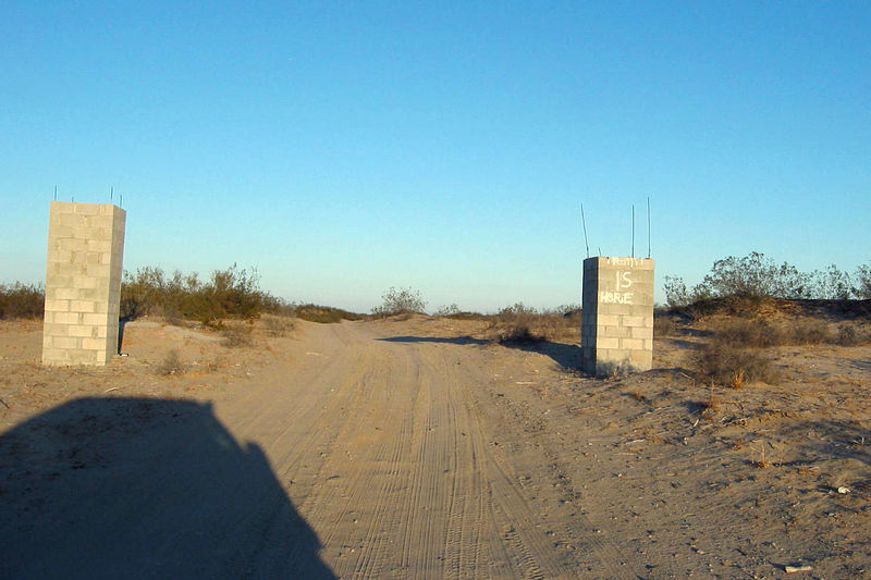
-- Geoff
|
|
|
CrisJk12
Newbie
Posts: 15
Registered: 4-25-2014
Location: San Diego
Member Is Offline
|
|
Thanks Geoff, that is the road I took. I remeber trying to read what was on the block.
|
|
|
| Pages:
1
2
3
4 |


