| Pages:
1
2
3
4 |
David K
Honored Nomad
        
Posts: 65413
Registered: 8-30-2002
Location: San Diego County
Member Is Offline
Mood: Have Baja Fever
|
|
Quote: Originally posted by JDCanuck  | Indeed it is one of the better graded-dirt roads, so I don't know why motorcycles should avoid unless the bike is just not suitable for any unpaved
road? If that is the case, a different bike should be considered because in Baja the pavement ends before you get to where you want to go!
Hi David: None of the pics you have posted yet indicated anything that would cause me to turn around, even with the K75. Keep them coming.
|
Glad to hear that JD! I think you have enough intel to enjoy yourself... Use my website to design your adventure! www.vivabaja.com
|
|
|
David K
Honored Nomad
        
Posts: 65413
Registered: 8-30-2002
Location: San Diego County
Member Is Offline
Mood: Have Baja Fever
|
|
Yes, I regret not paying to keep that url longer. I changed DavidKsBaja to VivaBaja over 16 years ago. After several years, I stopped paying for it.
Apparently those capitalist commies thought it was a great value to grab it??? LOL
|
|
|
JDCanuck
Super Nomad
   
Posts: 2345
Registered: 2-22-2020
Member Is Offline
|
|
I have a specific route question. Is there a back road route from Punta Marquez or Conquista Agraria down to Todos Santos? Seems a shame to have to
run all the way into La Paz and back down the highways to get there. Google maps seem to go dead midway and only show a big inland detour to get
across the one river.
|
|
|
David K
Honored Nomad
        
Posts: 65413
Registered: 8-30-2002
Location: San Diego County
Member Is Offline
Mood: Have Baja Fever
|
|
Quote: Originally posted by JDCanuck  | | I have a specific route question. Is there a back road route from Punta Marquez or Conquista Agraria down to Todos Santos? Seems a shame to have to
run all the way into La Paz and back down the highways to get there. Google maps seem to go dead midway and only show a big inland detour to get
across the one river. |
Both the new Benchmark 2021 Baja California Atlas and the old 2009 Baja California Almanac show the roads that parallel the coast south from Punta
Marquez area to Todos Santos. The Mexican topo map (CalTopo) shows them too.
|
|
|
JDCanuck
Super Nomad
   
Posts: 2345
Registered: 2-22-2020
Member Is Offline
|
|
Thanks David: That benchmark 2021 map looks to be what I need. Unfortunately only lists shipping to US eh?
Edited again: Found on Amazon, thanks David
[Edited on 8-11-2021 by JDCanuck]
[Edited on 8-11-2021 by JDCanuck]
|
|
|
David K
Honored Nomad
        
Posts: 65413
Registered: 8-30-2002
Location: San Diego County
Member Is Offline
Mood: Have Baja Fever
|
|
Here is the 2009 folding map from the Baja Almanac creator that shows the roads:

|
|
|
AKgringo
Elite Nomad
     
Posts: 6281
Registered: 9-20-2014
Location: Anchorage, AK (no mas!)
Member Is Offline
Mood: Retireded
|
|
The Naranjos road
I am not sure of the name or spelling of that route, but I drove it in November of 2020 from east, to west. It is a nice, scenic drive! I found a
place to sleep up near the summit, and was serenaded by goats, and cows wearing bells for most of the night!
The first half was excellent dirt that would be an easy drive in anything up to a motor home! The western, last quarter of the road was about the
same.
There were a couple of steep spots and water crossings on the west side of the divide that had been washed out and repaired, but nothing that I needed
to use 4x4 or low range for.
I would not want to drive a low clearance, or long wheel based rig over that section, but you probably could. All bets are off if there is a storm
before you ride it!
Edit; The water crossings were not deep, but a couple had steep approach or departure angles!
[Edited on 8-11-2021 by AKgringo]
If you are not living on the edge, you are taking up too much space!
"Could do better if he tried!" Report card comments from most of my grade school teachers. Sadly, still true!
|
|
|
David K
Honored Nomad
        
Posts: 65413
Registered: 8-30-2002
Location: San Diego County
Member Is Offline
Mood: Have Baja Fever
|
|
Quote: Originally posted by JDCanuck  | Thanks David: That benchmark 2021 map looks to be what I need. Unfortunately only lists shipping to US eh?
Edited again: Found on Amazon, thanks David
[Edited on 8-11-2021 by JDCanuck]
[Edited on 8-11-2021 by JDCanuck] |
It is also available as an app download for your smart phone or gps enabled tablet. It will show your location when in Baja.
|
|
|
JDCanuck
Super Nomad
   
Posts: 2345
Registered: 2-22-2020
Member Is Offline
|
|
Both the new Benchmark 2021 Baja California Atlas and the old 2009 Baja California Almanac show the roads that parallel the coast south from Punta
Marquez area to Todos Santos. The Mexican topo map (CalTopo) shows them too. [/rquote]
Thanks for the map suggestions, have them coming in mail.
|
|
|
Marty Mateo
Nomad
 
Posts: 110
Registered: 12-7-2019
Location: Vanisle Sur
Member Is Offline
|
|
Quote: Originally posted by AKgringo  | I am not sure of the name or spelling of that route, but I drove it in November of 2020 from east, to west. It is a nice, scenic drive! I found a
place to sleep up near the summit, and was serenaded by goats, and cows wearing bells for most of the night!
The first half was excellent dirt that would be an easy drive in anything up to a motor home! The western, last quarter of the road was about the
same.
There were a couple of steep spots and water crossings on the west side of the divide that had been washed out and repaired, but nothing that I needed
to use 4x4 or low range for.
I would not want to drive a low clearance, or long wheel based rig over that section, but you probably could. All bets are off if there is a storm
before you ride it!
Edit; The water crossings were not deep, but a couple had steep approach or departure angles!
[Edited on 8-11-2021 by AKgringo] |
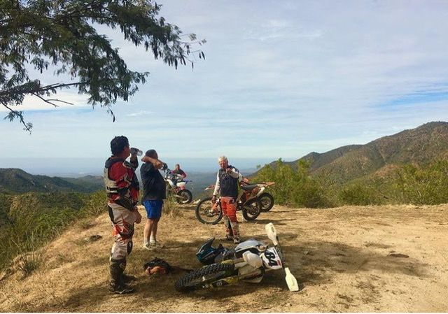
Los Naranjos rd, there is a sign beside the entrance to the Buddhist retreat on the east side .Great ride and seems to be graded once a year after the
rains. The west side of the summit is definitely the most challenging if you’re on a big bike ,especially before any grading is done . Coming from
west there are a few different ways in from the highway . Here’s a view point west of the summit.

|
|
|
motoged
Elite Nomad
     
Posts: 6481
Registered: 7-31-2006
Location: Kamloops, BC
Member Is Offline
Mood: Gettin' Better
|
|
He don't need no stinkin' pro.... but someone to hold his beer.
There is a north-south route from the west side that goes down to Cabo via La Candaleria village....
Don't believe everything you think....
|
|
|
JDCanuck
Super Nomad
   
Posts: 2345
Registered: 2-22-2020
Member Is Offline
|
|
Looks to me like it should be easily doable, assuming the routes from Ley Federal Agria Uno to El Rosario and then from Los Innocentes to Meliton
Albanez are not too destroyed in bad weather. I will have to check them out when i get down there.
[Edited on 8-15-2021 by JDCanuck]
|
|
|
JZ
Select Nomad
      
Posts: 13687
Registered: 10-3-2003
Member Is Offline
|
|
I actually did. Italian. Stopped around 7th or 8th grade.
I'm just a sh#tty speller.
[Edited on 8-15-2021 by JZ]
|
|
|
Marty Mateo
Nomad
 
Posts: 110
Registered: 12-7-2019
Location: Vanisle Sur
Member Is Offline
|
|
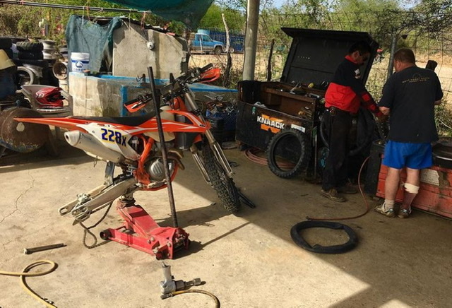
Ha ha ha , wondered if anyone would notice that. First and last ride with that guy , shortly after that pic was taken he put his foot peg into his
calf and I mean deep ugly hole in his calf. Then shortly after that got a flat and “surprisingly”had no spare tube or tools. You can see his blood
soaked sock in this pic

|
|
|
AKgringo
Elite Nomad
     
Posts: 6281
Registered: 9-20-2014
Location: Anchorage, AK (no mas!)
Member Is Offline
Mood: Retireded
|
|
Quote: Originally posted by JDCanuck  |
Looks to me like it should be easily doable, assuming the routes from Ley Federal Agria Uno to El Rosario and then from Los Innocentes to Meliton
Albanez are not too destroyed in bad weather. I will have to check them out when i get down there.
[Edited on 8-15-2021 by JDCanuck] |
I picked my way through the backroads in that area in 2014. It was fun, but a bit confusing sometimes, because the apparent "main road" sometimes
dead ended at a ranch!
The traffic to and from Mex 1 and the coast is more common than traffic traveling north and south.
The terrain is pretty flat, so much easier to maintain than some of the steeper mountain roads.
[Edited on 8-15-2021 by AKgringo]
If you are not living on the edge, you are taking up too much space!
"Could do better if he tried!" Report card comments from most of my grade school teachers. Sadly, still true!
|
|
|
| Pages:
1
2
3
4 |

